


 AGUA FRIA CANYON
Agua Fria National Monument
North of Black Canyon City
AGUA FRIA CANYON
Agua Fria National Monument
North of Black Canyon City
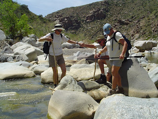
The guidebooks don’t mention the quicksand. The treacherous little sinkholes, disguised to look like normal sand, lurk along the beaches and in the sandbars of the Agua Fria river like so many land mines poised to suddenly grab onto a hiking boot and pull its occupant knee-deep into a mucky suction-hold. Quicksand is just one of the reasons why exploring in the canyon is not for the unadventurous or inexperienced. Following the rugged canyon where riparian vegetation flourishes on the shores, is quite difficult and requires complicated water crossings, boulder-hopping and route-finding skills.
The hike starts out easy enough along a well-defined dirt road that merges into footpaths along Badger Springs. About a mile in, Badger Springs dumps into the Agua Fria river. There, ancient rock art on the northeast canyon walls signals the beginning of the difficult portion of the hike. At the confluence, head right (west) and follow the water into the canyon, taking time to scope out the landscape ahead as rapids and vertical rock faces present a continual maze of hazards. A good pair of gloves and sturdy boots with traction help in spots where climbing the ledges high above the river is necessary to circumvent obstacles. It’s also a good idea to place cairns or trail flags at “critical move” locations to assist on the way out. Lots of sweat, determination and use of smart hiking skills will get you through the canyon safely and with a bit of luck, you may even spot some of the pronghorn and bald eagles that the guidebooks promote to a fault. We didn’t see any pronghorn, or eagles on our-April visit, however, two vultures riding the air currents above served as a reminder to tread lightly and with caution.
LENGTH: 3-12 miles (optional)
RATING: easy then DIFFICULT
ELEVATION GAIN: 560 feet
BEST TIME TO HIKE: fall thru late spring
GETTING THERE:
Take I-17 north past the Sunset Point rest area and then take exit 256 (Badger Springs Road). Turn right at the exit (east) and drive about a quarter of a mile to the signed Agua Fria National Monument kiosk. There are free maps and an interpretive sign there. Once you have your maps, continue down Badger Springs Road for about a mile to the obvious parking area where there is also a “Badger Springs Wash” sign. The hike starts there. No fees, no facilities, no water, no mercy…come prepared!


 AGUA FRIA CANYON
Agua Fria National Monument
North of Black Canyon City
The guidebooks don’t mention the quicksand. The treacherous little sinkholes, disguised to look like normal sand, lurk along the beaches and in the sandbars of the Agua Fria river like so many land mines poised to suddenly grab onto a hiking boot and pull its occupant knee-deep into a mucky suction-hold. Quicksand is just one of the reasons why exploring in the canyon is not for the unadventurous or inexperienced. Following the rugged canyon where riparian vegetation flourishes on the shores, is quite difficult and requires complicated water crossings, boulder-hopping and route-finding skills.
The hike starts out easy enough along a well-defined dirt road that merges into footpaths along Badger Springs. About a mile in, Badger Springs dumps into the Agua Fria river. There, ancient rock art on the northeast canyon walls signals the beginning of the difficult portion of the hike. At the confluence, head right (west) and follow the water into the canyon, taking time to scope out the landscape ahead as rapids and vertical rock faces present a continual maze of hazards. A good pair of gloves and sturdy boots with traction help in spots where climbing the ledges high above the river is necessary to circumvent obstacles. It’s also a good idea to place cairns or trail flags at “critical move” locations to assist on the way out. Lots of sweat, determination and use of smart hiking skills will get you through the canyon safely and with a bit of luck, you may even spot some of the pronghorn and bald eagles that the guidebooks promote to a fault. We didn’t see any pronghorn, or eagles on our-April visit, however, two vultures riding the air currents above served as a reminder to tread lightly and with caution.
LENGTH: 3-12 miles (optional)
RATING: easy then DIFFICULT
ELEVATION GAIN: 560 feet
BEST TIME TO HIKE: fall thru late spring
GETTING THERE:
Take I-17 north past the Sunset Point rest area and then take exit 256 (Badger Springs Road). Turn right at the exit (east) and drive about a quarter of a mile to the signed Agua Fria National Monument kiosk. There are free maps and an interpretive sign there. Once you have your maps, continue down Badger Springs Road for about a mile to the obvious parking area where there is also a “Badger Springs Wash” sign. The hike starts there. No fees, no facilities, no water, no mercy…come prepared!
AGUA FRIA CANYON
Agua Fria National Monument
North of Black Canyon City
The guidebooks don’t mention the quicksand. The treacherous little sinkholes, disguised to look like normal sand, lurk along the beaches and in the sandbars of the Agua Fria river like so many land mines poised to suddenly grab onto a hiking boot and pull its occupant knee-deep into a mucky suction-hold. Quicksand is just one of the reasons why exploring in the canyon is not for the unadventurous or inexperienced. Following the rugged canyon where riparian vegetation flourishes on the shores, is quite difficult and requires complicated water crossings, boulder-hopping and route-finding skills.
The hike starts out easy enough along a well-defined dirt road that merges into footpaths along Badger Springs. About a mile in, Badger Springs dumps into the Agua Fria river. There, ancient rock art on the northeast canyon walls signals the beginning of the difficult portion of the hike. At the confluence, head right (west) and follow the water into the canyon, taking time to scope out the landscape ahead as rapids and vertical rock faces present a continual maze of hazards. A good pair of gloves and sturdy boots with traction help in spots where climbing the ledges high above the river is necessary to circumvent obstacles. It’s also a good idea to place cairns or trail flags at “critical move” locations to assist on the way out. Lots of sweat, determination and use of smart hiking skills will get you through the canyon safely and with a bit of luck, you may even spot some of the pronghorn and bald eagles that the guidebooks promote to a fault. We didn’t see any pronghorn, or eagles on our-April visit, however, two vultures riding the air currents above served as a reminder to tread lightly and with caution.
LENGTH: 3-12 miles (optional)
RATING: easy then DIFFICULT
ELEVATION GAIN: 560 feet
BEST TIME TO HIKE: fall thru late spring
GETTING THERE:
Take I-17 north past the Sunset Point rest area and then take exit 256 (Badger Springs Road). Turn right at the exit (east) and drive about a quarter of a mile to the signed Agua Fria National Monument kiosk. There are free maps and an interpretive sign there. Once you have your maps, continue down Badger Springs Road for about a mile to the obvious parking area where there is also a “Badger Springs Wash” sign. The hike starts there. No fees, no facilities, no water, no mercy…come prepared!
No comments:
Post a Comment