

 LOST GOLDMINE TRAIL
Superstition Wilderness--kinda
LOST GOLDMINE TRAIL
Superstition Wilderness--kinda
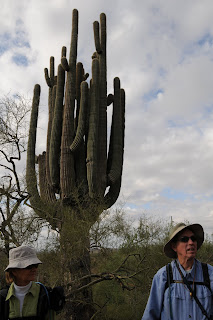
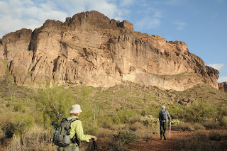
Looking for a place to indoctrinate your friends from Ohio to the glories of the desert Southwest--without the hassle of extreme terrain, bushwacking and befuddling routes? Then, try the Lost Goldmine Trail for a stress-free yet brag-worthy place to bring your out-of-town pals for an easy, photogenic hike. There’s no telling how many shots of this trail may have appeared on holiday cards sent from the Midwest. I’m guessin’---billions. One of the newer trails to grace the desert just outside of the Superstition Wilderness Area, this easy route is (when compared to other trails in the area) a leisurely stroll. Mostly flat and well-signed, Lost Goldmine Trail is a big draw for hikers, bikers and folks on horseback. Situated at the base of some truly magnificent volcanic cliffs, the route passes through pristine Sonoran desert terrain. Because of its non-challenging nature and excellent specimens of saguaro, jojoba, cholla and manic spring wildflowers, this scenic path makes for a classic desert outing. Expect lots of human company when hiking this trail from Fall through Spring---add snakes to the mix beginning early-April.
LENGTH: 5.75 miles one-way
RATING: easy
ELEVATION: 2,000 – 2,100 feet
BEST SEASONS: October - April
GETTING THERE:
West Trailhead: From Phoenix, go east on US 60 to Kings Ranch Road in Apache Junction. Turn left (north) and follow Kings Ranch Road to 2.8 miles to Baseline Road. Turn right and follow Baseline to Mohican, turn left and left again on Valleyview. Go 1.5 miles on Valleyview to Cloudview, turn right and continue to the large, signed parking area. Roads are paved up to the last 1.5 miles and are sedan-friendly.
East Trailhead: From Phoenix, go east on US 60 to about 8 miles past Apache Junction (near mile post 204) and look for the “Peralta Trailhead” sign on the side of the road. Turn left onto Peralta Road (Forest Road 77) and drive roughly 7 miles to the signed trailhead on the left. FR 77 is maintained dirt with a few rough spots. Although passable by sedan, high clearance vehicles are recommended.
DISTANCE FROM PHOENIX: 45 miles
INFORMATION: fs.fed.us/r3/tonto/wilderness/superstition


 LOST GOLDMINE TRAIL
Superstition Wilderness--kinda
Looking for a place to indoctrinate your friends from Ohio to the glories of the desert Southwest--without the hassle of extreme terrain, bushwacking and befuddling routes? Then, try the Lost Goldmine Trail for a stress-free yet brag-worthy place to bring your out-of-town pals for an easy, photogenic hike. There’s no telling how many shots of this trail may have appeared on holiday cards sent from the Midwest. I’m guessin’---billions. One of the newer trails to grace the desert just outside of the Superstition Wilderness Area, this easy route is (when compared to other trails in the area) a leisurely stroll. Mostly flat and well-signed, Lost Goldmine Trail is a big draw for hikers, bikers and folks on horseback. Situated at the base of some truly magnificent volcanic cliffs, the route passes through pristine Sonoran desert terrain. Because of its non-challenging nature and excellent specimens of saguaro, jojoba, cholla and manic spring wildflowers, this scenic path makes for a classic desert outing. Expect lots of human company when hiking this trail from Fall through Spring---add snakes to the mix beginning early-April.
LENGTH: 5.75 miles one-way
RATING: easy
ELEVATION: 2,000 – 2,100 feet
BEST SEASONS: October - April
GETTING THERE:
West Trailhead: From Phoenix, go east on US 60 to Kings Ranch Road in Apache Junction. Turn left (north) and follow Kings Ranch Road to 2.8 miles to Baseline Road. Turn right and follow Baseline to Mohican, turn left and left again on Valleyview. Go 1.5 miles on Valleyview to Cloudview, turn right and continue to the large, signed parking area. Roads are paved up to the last 1.5 miles and are sedan-friendly.
East Trailhead: From Phoenix, go east on US 60 to about 8 miles past Apache Junction (near mile post 204) and look for the “Peralta Trailhead” sign on the side of the road. Turn left onto Peralta Road (Forest Road 77) and drive roughly 7 miles to the signed trailhead on the left. FR 77 is maintained dirt with a few rough spots. Although passable by sedan, high clearance vehicles are recommended.
DISTANCE FROM PHOENIX: 45 miles
INFORMATION: fs.fed.us/r3/tonto/wilderness/superstition
LOST GOLDMINE TRAIL
Superstition Wilderness--kinda
Looking for a place to indoctrinate your friends from Ohio to the glories of the desert Southwest--without the hassle of extreme terrain, bushwacking and befuddling routes? Then, try the Lost Goldmine Trail for a stress-free yet brag-worthy place to bring your out-of-town pals for an easy, photogenic hike. There’s no telling how many shots of this trail may have appeared on holiday cards sent from the Midwest. I’m guessin’---billions. One of the newer trails to grace the desert just outside of the Superstition Wilderness Area, this easy route is (when compared to other trails in the area) a leisurely stroll. Mostly flat and well-signed, Lost Goldmine Trail is a big draw for hikers, bikers and folks on horseback. Situated at the base of some truly magnificent volcanic cliffs, the route passes through pristine Sonoran desert terrain. Because of its non-challenging nature and excellent specimens of saguaro, jojoba, cholla and manic spring wildflowers, this scenic path makes for a classic desert outing. Expect lots of human company when hiking this trail from Fall through Spring---add snakes to the mix beginning early-April.
LENGTH: 5.75 miles one-way
RATING: easy
ELEVATION: 2,000 – 2,100 feet
BEST SEASONS: October - April
GETTING THERE:
West Trailhead: From Phoenix, go east on US 60 to Kings Ranch Road in Apache Junction. Turn left (north) and follow Kings Ranch Road to 2.8 miles to Baseline Road. Turn right and follow Baseline to Mohican, turn left and left again on Valleyview. Go 1.5 miles on Valleyview to Cloudview, turn right and continue to the large, signed parking area. Roads are paved up to the last 1.5 miles and are sedan-friendly.
East Trailhead: From Phoenix, go east on US 60 to about 8 miles past Apache Junction (near mile post 204) and look for the “Peralta Trailhead” sign on the side of the road. Turn left onto Peralta Road (Forest Road 77) and drive roughly 7 miles to the signed trailhead on the left. FR 77 is maintained dirt with a few rough spots. Although passable by sedan, high clearance vehicles are recommended.
DISTANCE FROM PHOENIX: 45 miles
INFORMATION: fs.fed.us/r3/tonto/wilderness/superstition


