Find A Trail. Start Your Search Here:

Showing posts with label Bureau of Land Management. Show all posts

Tuesday, January 9, 2024

Vulture Mountain Ruins

VULTURE MOUNTAIN RUINS

Vulture Peak viewed from BLM 9052

Surrounded by an eclectic sampling of Arizona’s 194 named mountain ranges, The Vulture Mountains occupy a space rich in natural resources and human history. 

Hieroglyphic and Wickenburg Mountains view

The crescent-shaped range is comprised of a string of mounds 29 miles long and 13 miles wide located a dozen miles southwest of Wickenburg at the edge of Maricopa County.  
Hikers admire a twisted saguaro on BLM 9052

The Hassayampa River, a roughly 100-mile-long desert waterway that originates near Prescott and flows south, mostly underground, to merge with the Gila River, marks the eastern extent of the range. 
Saguaros dot a ravine in the Vulture Mountains

Its highpoint, 3,658-foot Vulture Peak, serves as Wickenburg’s most iconic land feature and the axis around which a cluster of defunct mining operations orbit.  
Hike begins with a crossing of the Hassayampa River

A network of Bureau of Land Management roads that are open to hikers, equestrians, and motorized use, provide access to the mineral-rich backcountry. 
Relics of mine ops in the Vulture Mountains

The main access point for exploratory adventures is by way of Gates Road in the community of Morristown.  The paved part of the road dead ends where Little San Domino Wash spills into the Hassayampa River.  

Relics protected by the Antiquities Act


From there, trail users may hike or drive across the usually dry floodplain to a gate where BLM road 9054 serves as entree to miles of dirt roads.  

Packrat middens are plentiful along BLM 9054

The best thing about hiking here is the joy of discovery.  Every road and side trail holds new vistas, natural arches, and points of interest, so there’s no bad plan.  Just pick a road and go.  One outing to try uses the clearly signed roads 9054 and 9052.

From the entry gate at the river, 9054 heads uphill, passing by the first of many optional side trips to an old mine site.  Mountain vistas make their first appearance at the top of a knoll with jaw-dropping looks at the Hieroglyphic and Wickenburg Mountains to the east, the Date Creek and Weaver Mountains to the north and the Bradshaw Mountains on the far northern horizon.

Washes feed into the Hassayampa River

Hikers trek BLM 9052

As the undulating route delves deeper into the boondocks, the distinctive forms of Vulture Peak and 3,044-foot Caballeros Peaks stand out to the northwest standing high above a cholla and saguaro studded landscape. 

Date Creek and Weaver Mountains to the north

At the two-mile point, this trip heads left onto road 9052, gaining and loosing elevation steadily.  At the 2.9-mile point, road 9052 veers left at a large white tank, then heads downhill and crosses a couple of washes before heading up yet again to meet an array of roadside mining detritus.  These minor prospects might have been the spawn of a nearby major mine operation.  The Vulture Mine and its companion Vulture City community was the hub of gold and silver extraction from 1863-1942. The core operation and a smattering of pick-and-shovel prospects mined the surface gold that was easily extracted by hand from exposed late Cretaceous pluton of quartz porphyry that shed bits of precious minerals in flakes, nuggets, and dust. 

Serial misfortunes including mismanagement, low gold prices, and high overhead caused sporadic closures and ownership changes until production in the area dribbled to a halt 1942. Some residual mineral extraction happened during World War II and limped into the 1960s when lingering deposits of copper, gold and lead were pulled from tailings and open shafts.

The abandoned Vulture Mountain mine sites had names that underpin their mysterious pasts. Details of the yields and histories of the Newsboy Mine, Montezuma Mine, Queen of Sheba Mine, El Tigre Mine, et al are buried in dusty boxes full of decades old claims.  

Artifacts near a mine prospect

Only the

Vulture Mine retains a semblance of its former glory. The site is now a privately owned tourist venue that preserves the dream of pulling riches from the desert. The lesser wildcat strikes live in comparative obscurity along ragged dirt roads in the hills above the Hassayampa River.  There’s little left to mark many of the small prospects.  Discarded cans, rotting wood planks, rusty nails and tailings scattered among chunks of quartz and metamorphic rocks crusted with brilliant blue green chrysocolla, a soft mineral associated with copper ore.

Gate at the Hassayampa River

When visiting historic sites, it’s important to help protect them. Federal law states that it is illegal to remove any artifact 50 years-old or older from public lands  (36 CFR 800,Title 18: Theft and Destruction of Government Property, the 1906 Antiquities Act, and the National Historic Preservation Act (NHPA) of 1966). An artifact is defined as anything made, modified, or used by humans. That would include cans, bottles, bricks, nails, tools, weapons, etc. When in doubt--leave it!  The historic artifacts link below helps identify common sightings.

Vulture Mountain scene on BLM 9054

At a spot along road 9052 that was probably a favorite lunch break hangout, dozens of rusted cans, crumpled metal, and sun-bleached wood litter a hillock overlooking the expanse of the Hassayampa Basin. To the southwest, the silhouette of the Harquahala Mountains rise to 5,681 feet above the flatlands filling the skyline.

Enjoy the discovery, but leave as is.


It’s easy to see why work wary miners would choose this serene locale to kick back with a can of beans after a long day of digging leaving behind relics for us to ponder.

LENGTH: 8.3 miles (to the lunch miner lunch spot and back)

RATING: moderate

ELEVATION: 1,767– 2,229 feet (1,225 feet of accumulated elevation change)

GETTING THERE:

From Phoenix, go north on Interstate 17 to State Route 74 (Carefree Highway).  Take SR 74 west (toward Wickenburg) for 30 miles to U.S. 60. Turn left and go 0.8-mile on U.S. 60 to Gates Road at milepost 121, turn right and continue 2.3 miles to the trailhead at Little Domingo Wash. Do not park within a quarter mile of the livestock water tank and respect private property in the area. Access roads are paved.

FUN HISTORY & SCIENCE:

http://docs.azgs.az.gov/OnlineAccessMineFiles/S-Z/VultureMaricopa273-2.pdf

HISTORIC ARTIFACT IDENTIFICATION GUIDE:

https://www.ntc.blm.gov/krc/system/files?file=legacy/uploads/22015/HistoricArtifactIDGuide.pdf


Tuesday, April 5, 2022

Black Canyon Trail: Windmill Valley Segment

BLACK CANYON NATIONAL RECREATION TRAIL: WINDMILL VALLEY SEGMENT

Cactus close in on the Black Canyon trail near Lake Pleasant

Registering somewhere between a honk and a howl, the vocalizations of the feral burros that roam around Lake Pleasant are as gritty and unbridled as the beasts themselves.

Wild burros roam the Windmill Valley segment

Sturdily built and resilient,
the desert-adapted, North African imports first arrived in Arizona in the 1600s carrying supplies with Jesuit priests.
Bradshaw Mountain vistas early in the hike

Valued for their strong backs and hardy work ethic, the burros soon found additional employment with prospectors. During boom times, they hauled ore but when the mines went bust, they either wandered off or were released into the wild where they thrived in the arid territory. 
Cholla cactus bloom April through May

Make no mistake, these docile-looking vegetarians are not to be messed with. Unlike their cousins the horse, these rough-around-the edges members of genus Equus are hardly the type to stride elegantly before feathered fascinators at a racetrack.

They can be scrappy and so it’s smart to observe them from a distance. Hikers can almost bet on seeing the free-roaming wild donkeys, that average about 350 pounds when full grown, in the Bureau of Land Management’s Lake Pleasant Herd Management Area which is located 25 miles north of Phoenix, west of Interstate 17, north of Carefree Highway (State Route 74) and northeast of the lake.

Desert snow blooms March through May

American carrot grows in a fire scar along the route

Much of the Black Canyon National Recreation Trail passes through this swath of Upper Sonoran Desert in the hilly backcountry of the Agua Fria River watershed.
Mesquite trees color a wash bright green

New River Mountains viewed from a high point

The 3.5-mile Windmill Valley segment, which is just a few miles east of the lake, is a scenic trek that winds through prime burro habitat. 
Bladder sage bloom March through June

The hike begins across the road from the Table Mesa trailhead with an easy walk among huge saguaros with majestic views of the Bradshaw Mountains to the north and a flank of flat-topped mesas near the north coves of Lake Pleasant.
Brilliant magenta Strawberry hedgehog cactus

Table Mesa (far right) seen from the trail

The trail quickly descends into a wash area and fire scar.  Torched trees and ashen cacti stumps belie an understory of resurgent shrubs and wildflowers. It’s in this short section of trail where the most species are found.

Buckwheat is a common find February through June

Look for desert marigold, chia, owl clover, desert snow, scorpion weed, globemallow, woolly daisy, white ratany and frilly American carrot.
White ratany blooms April through October

Beyond the fire damage, the trail traces a network of washes, bouncing between ridges and drainages as it gradually climbs 500 feet.  High points showcase vistas of the New River Mountains, Table Mesa and acres of scrubland where springtime color breaks in colorful cactus blooms, golden brittlebush, buckwheat and rare specimens of bladder sage.
Wide open rangeland on the Black Canyon Trail

The remainder of the route twists around stone pinnacles, rolling hills and rangeland ending at the Doe Springs Segment 7.7 miles (on trail)  north of the Emery Henderson trailhead on New River Road.

Low growing woolly daisies bloom Feb - May

While the Doe Springs junction makes for a good turnaround point, hikers can opt to customize the hike length by way of a car shuttle or tying in with the popular Boy Scout Loop for a more rigorous out-and-back trek through burro land.
Miniature wool star bloom March - June


LENGTH: 3.5 miles one-way

RATING: moderate

ELEVATION: 1,921 – 2,450 feet

GETTING THERE:

Table Mesa Trailhead. From Interstate 17, 36 miles north of Phoenix, take the Table Mesa Road exit 236.  At the end of the off ramp, turn left, go a few yards, and then veer right onto Frontage Road (the unsigned west end of Table Mesa Road).  Continue to the large “Table Mesa West” sign, turn left, and continue to the Table Mesa trailhead at kiosk No. 5 on the right, 3.1 miles from I-17.   To reach the start of the hike, walk a few yards farther down Table Mesa Road to the BCT sign on the left.

Roads are maintained dirt/gravel, suitable for all vehicles.

NOTE: While the Black Canyon Trail is not open to motorized travel or shooting, the surrounding area is popular with OHV riders and recreational shooters. Dust and noise may be noticeable.

INFO: Black Canyon Trail Coalition https://bctaz.org


Monday, November 16, 2020

Black Canyon Trail to Russian Well

Black Canyon Trail to Russian Well

The working windmill at the Russian Well site

The Black Canyon National Recreation Trail is quietly expanding its northern reach.

Efforts to extend the 80+-mile historic route that stretches from Phoenix to the outskirts of Prescott are taking shape in the Verde Ranger District of Prescott National Forest.

Black Canyon Trail is expanding in the Prescott National Forest

While there are already numerous easy-access trailheads scattered along the route, plans for better connectivity and loop options in the Verde Valley are in progress. 

Scenic spot at the hike's high point

One off-the-beaten- path trailhead that’s currently open and flagged for enhancement is the Russian Well segment northeast of the town of Mayer.  Situated in stunning back country of rolling hills, washes and scrubby rangeland, this remote stretch of trail, which (as of this writing) follows a signed temporary alignment on dirt roads is also packed with relics of the area’s past.
Rustic stone structure at Russian Well

It’s a starkly beautiful, curious place with multiple personalities.  The hike starts out with a walk among low-growing pockets of mesquite, scrub oak, cacti, yucca and thickets of cat claw shrubs that punctuate largely barren grasslands.  The undulating path dips and climbs through wide open spaces where domestic cattle graze and deer might be sighted darting among scant stands of juniper trees.  At the top of the first rise, the cottonwood-lined course of Yarber Wash in a depression below cuts a ribbon of color among the muted tones of the surrounding chaparral.

Black Canyon Trail traverses mineral-rich back country

 The road twists downhill and crosses the sandy riparian strip before heading uphill again to a cattle guard and fence line signed for U Cross Ranch. 
Russian Well site and Copper Mountain (center horizon) seen from the trail 

Another mild uphill section lands at a corral where some of the most sweeping vistas of the hike come into view. Look for the long profile of the Bradshaw Mountains in the west, Pine Mountain Wilderness to the east and the prominent peak of Copper Mountain to the southwest.  Strewn with salt licks (blocks of minerals placed for resident cattle) and strung with barbed wire, the high corral site marks the beginning of the history segment of the hike.
The trail crosses tree-lined Yarber Wash

 
Artifacts at the abandoned Tri-Metal Mine site

A water trough at Russian Well attracts wildlife

From here the road approaches the boundary of Prescott National Forest and enters Bureau of Land Management territory and dips downhill along a rough road cut that exposes some of the complex geology that attracted prospectors to mineral-rich volcanic deposits.  At the 2.9-mile point, the trail encounters an intersection above the tiny oasis of the Russian Well outpost. 

U Cross Ranch site on the Black Canyon Trail

The left fork heads up to the Tri-Metals Mine while the right spur continues downhill on the Black Canyon Trail to the well.  The Russian Well locale makes for interesting exploring.  Ringed by massive, clearly ancient junipers, the site straddles Brushy Wash, a deeply incised drainage where a working windmill pumps groundwater into a collection of tanks and an open-air water trough.  A picturesque, partially collapsed stone building surrounded by splintered timbers and metal scraps stands above a small corral at the edge of the wash. 
The corral at Russian Well

Juniper trees surround the Russian Well corral

A walk around the place reveals signs of active wildlife, including raucous, steel-blue pinion jays that flit around the water trough, and scatterings of rusted cans and odds-and-ends that reveal little about the well’s original builders except maybe they ate beans and drank beer.  As with all heritage sites, leave everything as you found it. 
Prescott National Forest mountain views abound on this hike

Russian Well is the turnaround point for this hike, however, the trail continues south on the route’s Copper Mountain segment.
Ruins of the Tri-Metal Mine prospect

It’s 10.2 miles to the next substantial access point—the Big Bug trailhead off State Route 69 near the town of Mayer.  For an out-an-back hike, there’s more to explore on the return trip.  Hike back up to the road junction and follow the opposite fork to the mine.
Scrubby rangeland dominates the hike

During its operating life, the defunct Yavapai County prospect yielded silver, gold, copper and lead.  Two filled-in digs, waste piles and a group of disintegrating concrete foundations and structures are all that remain.  You’d be hard pressed to find any remnants riches lying about, but a display of oxidized detritus like nuts, bolts and unidentifiable parts scattered among the ruins are more mundane treasures to observe in place while gazing out over layers of foothills and mountain peaks.  

LENGTH: 7.1-mile round trip as described here

RATING: moderate

ELEVATION: 4,189 – 4,517 feet

GETTING THERE:

From Phoenix go north on Interstate 17 to the Orme/Dugas Road exit 268 north of Cordes Junction.  Turn left at the bottom of the offramp and follow Orme Road (County Road 169) 7.1 miles to the trailhead on the left.  There’s a Black Canyon Trail sign at the entrance to a large dirt lot.  Hike begins at the trail post at the south side of the lot

Roads are maintained dirt suitable for all vehicles.

INFO: Black Canyon Trail Coalition

http://bctaz.org/

Monday, February 16, 2015

SAN PEDRO RIVER TRAIL

SAN PEDRO RIVER TRAIL
San Pedro Riparian National Conservation Area
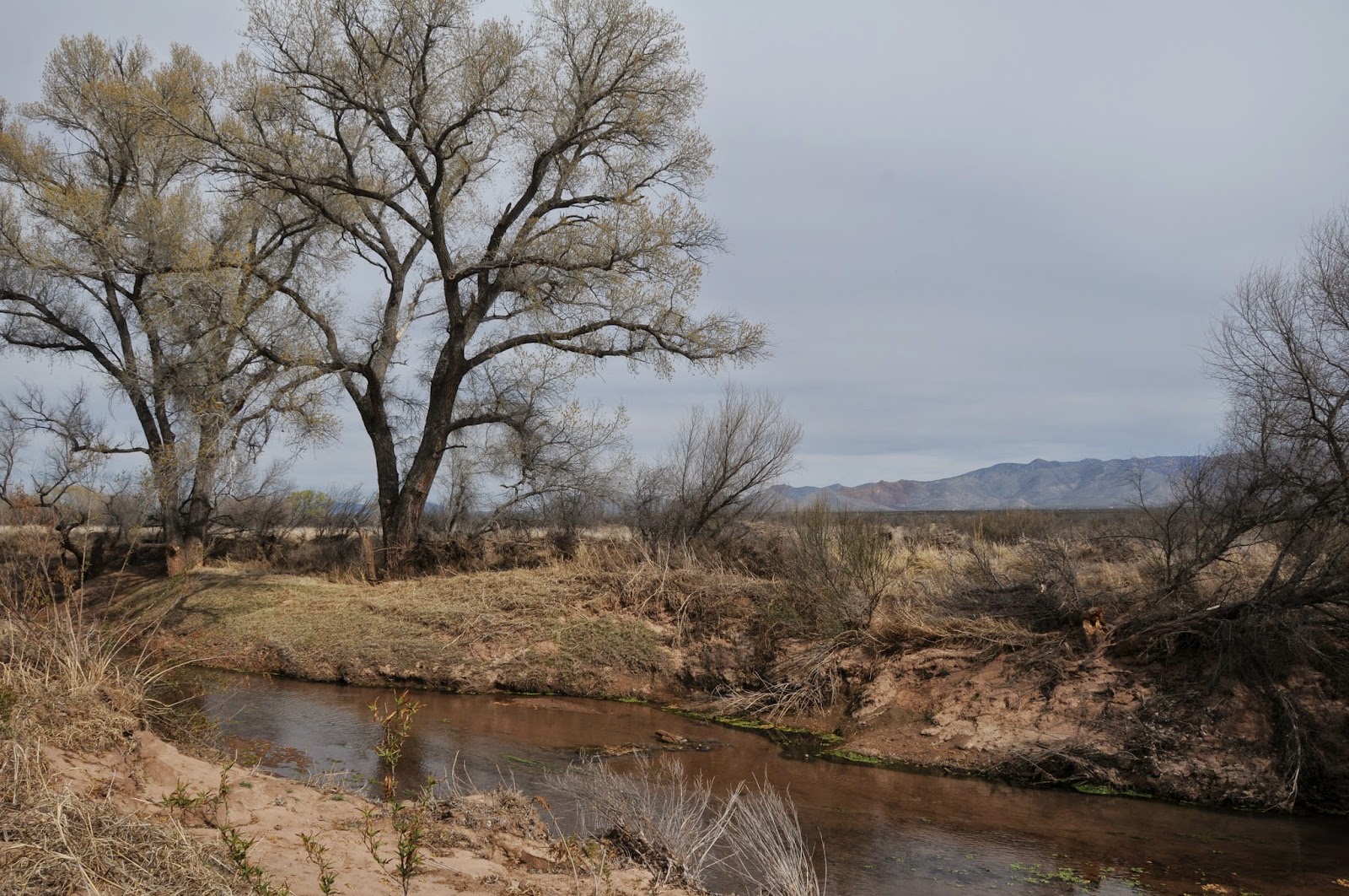
San Pedro River 

From its headwaters in Sonora Mexico to the confluence with the Gila River near Winkelman, the San Pedro River flows 140 miles north through 57,000 acres of riparian wildlife habitat surrounded by scrub and sprawling grasslands of the Sonoran and Chihuahuan deserts. Cradled between the high peaks of the Huachuca Mountains and the ore-rich hills around Bisbee, the river is one of the last free flowing waterways in the Southwest.

Over its lacy course, the unbridled river unfolds in idiosyncratic oxbows, linear pools, marshes and mesquite-cluttered floodplains giving a glimpse of what the area might have looked like to ancient inhabitants.

The 27-mile San Pedro River Trail runs adjacent to the water and a web a spur paths leading to the muddy banks and pebble-strewn sandbars add myriad opportunities for viewing some of the 350 species of birds, 80 species of mammals, 68 kinds of reptiles and amphibians and 2 species of native fish that reside in a tangled forest of cottonwood, willow and ash trees.

Numerous trailheads and backcountry camping areas are spread long the trail's length making for easy car shuttle, day hike or backpack outings.

The well-signed route is peppered with sites that chronicle the area's human history. There's a Clovis Paleo-Indian culture locale (11,000-8,000 B.C.), petroglyph gallery, mammoth kill pit, remnants of Spanish and Mexican colonial explorations and the foundations of territorial ranching and mining outposts. Taking in the entire scope of SPRNCA is a multi-day venture, but for a quick day trip or to learn more about the conservation area, a good place to start is at the San Pedro House trailhead. Here, knowledgeable volunteers from the Friends of the San Pedro River host guided hikes and are on hand to help optimize your itinerary. This is also the stepping out point for a trek along the San Rafael del Valle section of the route that culminates 8 miles upstream at the Hereford Bridge trailhead.
LENGTH: 27 miles one-way
or 8 miles one-way for the San Rafael del Valle section
RATING: easy
ELEVATION: 3762' - 4071'
FACILITIES: Restrooms, bookstore, picnic tables at San Pedro House. Restroom at Hereford Bridge.
FEES: No trailhead fees. Backcountry camping permits are $2 per person per day.
GETTING THERE:
From Phoenix, take Interstate 10 east toward Tucson. Continue to the AZ90 Fort Huachuca/Sierra Vista exit #302. Follow the AZ90 signs through Sierra Vista, then:
SAN PEDRO HOUSE TRAILHEAD:
From Sierra Vista, continue east on AZ90 to milepost 328 and turn right (south) at the sign just before the bridge.
HEREFORD BRIDGE TRAILHEAD:
From Sierra Vista, continue east on AZ90 to Moson Road (traffic light just past milepost 325), turn right and continue 7.6 miles to Hereford Road. Turn left, go 4.6 miles and turn right at the sign just past milepost 8 before the bridge. Roads are paved up to the 0.1-mile access roads which are good gravel.
INFO & MAPS:
San Pedro Riparian National Conservation Area, (520) 439-6400
San Pedro House Trails System: (520) 458-3559
Friends of the San Pedro River
MORE PHOTOS: