Find A Trail. Start Your Search Here:

Thursday, December 28, 2017

2018 WILL BE AN EPIC YEAR FOR THE MARICOPA TRAIL
2018 WILL BE AN EPIC YEAR FOR THE MARICOPA TRAIL
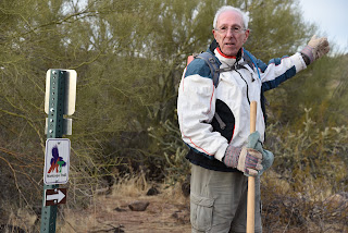
Rick Kesselman of the Maricopa Trail + Park Foundation
Maintaining and advocating for the Maricopa Trail is a labor of love for Rick Kesselman, Trail Director and segment steward of the Maricopa Trail+ Park Foundation (MTPF).
The 300+-mile trail that circles the Valley is a work-in-progress and amazingly, many Arizonans are unaware of this remarkable route and the efforts behind its creation and its exciting future.
New sign installed along the race route on 12-23-17.
I caught up with Rick and a troop of volunteers on a crisp December morning as they were preparing a section of the trail that runs between Spur Cross Ranch Conservation Area and Lake Pleasant Regional Park for the 2018 Prickly Pedal mountain bike race. This roughly 40-mile mountainous section of the trail is one of the most technically challenging and visually appealing for hikers, bikers and equestrians alike making is the perfect stretch to host the fund-raising event that supports the trail. Kesselman had plenty to say when I asked why trail users should care about this epic route.
MT between Spur Cross and Lake Pleasant is visually stunning
Its landscapes, environs, flora and fauna lead trail users to unbounded outdoor adventures, from myriad unique Sonoran Desert parks and educational Nature Centers, to healthy trail, mountain, and lake activities with direct links to scores of welcoming community parks and trails,” Kesselman said. “These community linkages comprise the essence of our Foundation's Maricopa Trail Communities Program.  This Program will help focus growth in the Valley's Active Planning efforts to provide completely linked community trail systems with each other and the amazingly large Maricopa Trail and County Regional Parks system. The MT adds a unique treasure for its residents, visitors and tourists.” Kesselman went on to laude the multi-level cooperative efforts involved in the trail's overall mission. “Maricopa County Parks and Recreation Department (MCPRD) and the Maricopa Trail and Park Foundation feel that it gives communities, its residents an opportunity to use our facilities. It connects the ten (soon to be eleven) County parks as well as the individual city and town trail systems throughout the Valley.

There are fewer prickly snags thanks to MTPF volunteers
MCPRD consider it a linear park. As with any trail system, if you don’t maintain it then it will fall apart, become a safety concern and not allow the user a good experience.”
Hiking the MT toward Lake Pleasant

Rick Kesselman

The “main loop” of the Maricopa Trail is currently 310 miles long, but future plans will add length and more connectivity to the route.
Much of the remaining work on the trail will be finished in 2018. “The main circular loop will be completed in June upon acquisition of three State Land portions that we have been waiting three years to acquire. It is currently 99.9% complete,” Kesselman said. Connectors to Buckeye Hills Regional Park and the future Vulture Mountain Regional Park are still in the planning stages. Once those spurs are completed, plans will be drawn up to connect city trail systems as well.
MTPF volunteers maintain the route.
The latest part of the trail to be completed is the 15.9-mile Segment 22 that runs between McDowell Sonoran Preserve and the Bronco Trailhead in Tonto National Forest.
Mountainous terrain defines the Prickly Pedal race course

On Jan 20, 2018, up to 350 riders will participate in the third annual Prickly Pedal Mountain Bike Race, an event that helps support the building and maintenance of the MT.  The event is organized by MTPF, a non-profit organization that works to protect, promote, develop, and maintain Maricopa County Regional Park trails through sustainable financial support and volunteer programs. For safety reasons, the race course section of the MT will be closed to all but participants on the day of the event.

Kesselman instructs trail volunteers
Those who wish to contribute or volunteer with MTPF don't need any special skills to do so.
Our Comprehensive Stewardship Training program trains our Crew Leaders and Trail Crew volunteers.” Kesselman said. “No previous skills are necessary. We also have volunteer opportunities beyond trail work such as marketing, social media, website administration, fundraising, etc. Prospective volunteers can go to the “Events” tab on our website home page to learn about volunteering opportunities and then to the “Volunteer, then Stewardship” tab to volunteer."
Maricopa Trail + Park Foundation
MAPS:
Prickly Pedal Race

Tuesday, December 26, 2017

HOLBERT TRAIL

HOLBERT TRAIL, South Mountain Park, Phoenix
Dobbins Lookout
On clear evenings, the beacons on Mount Suppoa that bleep and flinch above an array of communication equipment are visible from many parts of the Valley.  The spindly forest of red-lighted poles marks the highest point in South Mountain Park.  The 2690-foot summit is off limits to the public but equally swell sights can be had at nearby 2330-foot Dobbins Lookout.
Hikers on the Holbert Trail
Dobbins Lookout
You could drive up to this Depression Era observation deck, but for those who prefer to sweat for it, the Holbert Trail provides a moderately difficult slog and rewarding discoveries all the way up.  The hike is as much a trek through history as it is a respectable workout.  The trail winds up the north face of the Guadalupe Mountain Range---one of the three elongated ridges that make up South Mountain. The others are the Gila and Ma Ha Tauk ranges.  The first history lesson comes within a half-mile of the trailhead where the route cuts through a box canyon of pre-Cambrian stone that’s older than primordial ooze.
Hikers on the Holbert Trail
The rocks that predate all life on earth have survived eons of change, and their disintegrating, sun baked surfaces have served as canvas for the etchings of ancient inhabitants including the Hohokam people who made many of the intricate symbols visible on boulders and cliff faces throughout the hike. While images that look like water birds, turtles and sheep might be easy to understand, the meaning of artful spirals, crosses and cryptic figures may never be known.  Be sure to scope out the surroundings as petroglyphs seem to pop up in the most unexpected places.  As with all heritage sites, be respectful by not touching, rubbing or (gak) altering with graffiti or adding chalk to make them more visible. Sadly, many of the irreplaceable images have been lost or damaged by careless visitors.
Beyond “petroglyph alley” the trail begins a steady climb over wide switchbacks that move between canyon-bound passages and edge-clinging escarpments.  The trail ends at Telegraph Pass Road, but a more interesting option is to skip the last 0.3-mile and instead take the spur trail that leads to the lookout.  The native-stone-and-concrete structures as well as many of the park’s more than 50 miles of trails were built by the Civilian Conservation Corps between 1933 and 1940.  An exhibit at the South Mountain Environmental Education Center gives insight to the program and the historic structures located within park. 
Downtown Phoenix seen from the Holbert Trail
At 16,000 acres, South Mountain is one of the largest municipal parks in the nation.
Dobbins Lookout
The wear and tear of generations of use by outdoor enthusiasts has taken a toll on the park’s condition. Many of the old trails were not built to modern sustainability standards and structures such as picnic ramadas no longer suit contemporary needs. That’s why the park is getting a major facelift that will include new facilities, stabilized trails, some new trails and improved parking. The first phase is nearing completion at the Pima Canyon trailhead.
Ascending the Holbert Trail
Compass at Dobbins Lookout
Valley views from Dobbins Lookout
The Dobbins Lookout provides a platform to contemplate what a treasure South Mountain is to our community. A compass post overlooking the Valley points to local landmarks, mountain ranges, farmlands, cities and suburbs that have grown up around the park.  Just as these surrounding elements have morphed and bloomed over time, so South Mountain Park adapts to accommodate.
Petroglyphs on Holbert Trail
LENGTH: 4.8 miles roundtrip
DIFFICULTY: moderate
ELEVATION: 1,350'-2,330'  
FACILITIES: restrooms, water, picnic tables, covered ramadas
GETTING THERE: Holbert Trailhead, 10919 S. Central Ave.
From central Phoenix, follow Central Avenue south all the way to the end where it flows into South Mountain Park. Just past the park entrance gate, turn left into the Activity Complex. Drive past the Interpretive Center and go all the way to the end of the road near the restrooms and park. The signed trailhead is directly across the road. Trailhead gates  are open from 5 a.m. to 7 p.m. daily. Trails remain open until 11 p.m.
INFO & MAPS:

Monday, December 18, 2017

DINOSAUR WASH

DINOSAUR WASH
A slot canyon in Dinosaur Wash
If you stay alert on this hike, it’s easy to spot the Stegosaurus.  But you’ll have to navigate a convoluted trail system to get to it; and that’s not so easy.
The  Stegosaurus-shaped rock outcropping looms above Dinosaur Wash with its head twisted back over a scaled spine frozen in a posture that looks like the losing side of a Jurassic joust.  This signature basaltic formation is the only “dinosaur” you’ll see while trudging through the eponymous wash that’s a part of the Sophie’s Flat Trail system north of Wickenburg.  What you will see though, is a mix of spectacular desert vistas, hardscrabble gullies, volcanic peaks and a matrix of sandy washes.  
Dinosaur Wash

Although it’s just a few miles north of town, the trail system has a pure wild west, middle-of-nowhere feel. The looped trails are blandly named A,B,C,D and E, but they’re anything but boring.  The core A Trail begins at the Sophie’s Flat trailhead where there’s ample parking, a horse staging area and restrooms.
View from the pass
A map kiosk shows the trail layout that belies a confusing start, missing signs and several tricky turns.  The trek to Dinosaur Wash involves linking the A, B, C and D trails for a 9.5-mile out-and-back hike. 

The most difficult route-finding happens near the start where after descending to a sprawling arroyo, the A Trail gets swallowed up in shifting sands.  Although there are signs in the wash, they are tough to find. However, once at the point where the A Trail begins its first uphill ascent, signage becomes clearer.  From beginning to end, it’s a challenging hike with continual dips, climbs and calf-burning slogs through beachy washes.  
It's a tough hike with lots of ups and downs,
The dinosaur rock
After 3 miles, the best views of the hike come at a mountain pass between Creighton Peak and Red Top where the serpentine course of the Hassayampa River and tendril drainages whittle through a desert of ragged peaks and chiseled canyons.  From the pass, the route dives down toward the destination. Watch carefully for another befuddling junction where the trail meets two A Trail sign posts near a giant boulder. Look for an unsigned path that heads north between the two signs. This is the D Trail that leads to the wash. As you trudge downhill among ocotillos and hedgehog cacti, keep an eye out for the stegosaurus rock formation looming out from the cliffs. Some argue that it looks more like a bear, lizard, hawk or a boa constrictor. Regardless of what one might see in the lithic form, it’s an entertaining point of contention and a great photo opp.  
Geological stew in Dinosaur Wash
Hang a left where the path dead ends at the wash.

You might want to tie a bandana here (take it with you when you return) because beyond this point, there are no trail signs and this junction is easy to miss on the way back.  The next mile of hiking is the icing on the cake for those who have managed to get through the maze.  Dinosaur Wash expands and contracts as it wiggles through sections of a broad dry river course, stony corridors and box canyons built of churned and jostled lava flows, sculpted sediments and fossil stream beds.
Uninspiring names for inspiring trails
Look for chunks of blue basalt tossed with red sandstones, an old mining claim and rock pockets dripping with pack rat middens.
Hikers on the A Trail
Other than the pain of hiking through sand and a few minor down climbs, reasonably fit hikers should be able to get to the 4.97-mile point where a slick rock drop off would require more serious scrambling to continue another mile to the Hassayampa River, Mistake Mine Ruins and the Box Canyon. The drop off makes for a good spot to take a break and discuss (or argue) over whether the dino rock is a bird, reptile or mammal before heading back the way you came.
On the B Trail


HIKE DIRECTIONS:
From the trailhead, follow A Trail 1.1-mile to B Trail. Follow B Trail to the 1.88-mile point, veer right and follow C Trail to the 2.39-mile point and turn left on the A Trail. Follow A Trail to the 2.91-mile point and connect with D Trail.  Follow D Trail less than a mile, drop into the obvious course of Dinosaur Wash and head northwest (left).  Hike to the 4.97-mile point and turn around at a slick rock drop off.
LENGTH: 9.5 miles roundtrip
RATING: moderate
ELEVATION: 2337’- 2789’ (1100’ cumulative gain)
Overlooking the Hassayampa River basin
FACILITIES: restroom, map kiosk
GETTING THERE: Sophie's Flat Trailhead:
From Phoenix go north on Interstate 17 to Carefree Hwy/State Route 74 (exit 223). Go 30 miles west on SR 74 toward Wickenburg, turn right at US60 and continue to just before the Hassayampa River Bridge traffic circle in Wickenburg.  Turn right on El Recreo, go 0.25 mile and veer right onto Constellation Road. Continue 2.7 miles, turn left onto Blue Tank Road and drive 1.3 miles to the trailhead on the right. The last 4 miles are on undulating dirt roads suitable for sedans.
INFO:

Monday, December 11, 2017

SUBMARINE ROCK TRAIL

SUBMARINE ROCK TRAIL
Hog Wash Trail
Hikers of a certain age will remember the 1960s TV submarine series Voyage to the Bottom of the Sea. Each week kids across the nation could vicariously board the Seaview with Admiral Nelson for a new nail-biting peril, a new monster and an old predictable plot as seen through the sub’s massive control room windows.
Broken Arrow Trail
For me, the wonder of it all lasted up until a class trip to a naval base in Groton, CT where I got to walk through the tin-can corridor of a real-life docked sub. We kids lurched single file past walls of gauges, dials and buttons in sync with a baseline of parental “don’t touch, stay back, keep quiet”. But, unlike on the Seaview, there were no windows-- which dashed my hopes of a beastly freak festival. For those of us who had toed the line, the tour culminated with a consolation prize: a trip to a local ice cream parlor. It wasn’t exactly the one-eyed squid from outer space finale I had hoped for, but the tour fueled my life-long fascination with underwater suspense books and films.  (Yes, I have really watched U-571 three dozen times). 
Submarine Rock (center) floats in a sea of green
While there may not be any deep-sea-creature-themed sub tours here in land-locked Arizona, we do have the next best thing to a mutant flying beluga whale encounter: Sedona.
Given my childhood experience, I was naturally intrigued when I came across the Submarine Rock Trail while hiking Sedona’s Broken Arrow Trail a few seasons ago. That path wasn’t on the day’s agenda, so it took a slot on my hike to-do list.  The trail is situated just outside of the Munds Mountain Wilderness on the east edge of the Twin Buttes cluster of trails near the Chapel of the Holy Cross. Several trails and trailheads offer dozens of ways to build your own route to get to it. On my bucket list return visit, 
A juniper frames Wilson Mountain
I started at the lesser-known Mystic Trailhead and used the Hog Wash and Broken Arrow Trails. The trek wraps around vertical sandstone pillars for constantly changing views of Red Rock Country landforms including Capitol Butte, Wilson Mountain and the massive profiles of Lee and Munds Mountain.
The route also has an optional short side trip to Devil’s Dining Room, a bat-inhabited sinkhole off the Broken Arrow Trail.  Once through a corridor of cypress, yucca and slick rock, views open for a first look at Submarine Rock. The torpedo-shaped red rock outcropping looks remarkably like a submersible ship cruising the surface of an other-worldly ocean. 
Capitol Butte (left) seen from the Mystic Trail

The terrestrial vessel rests at the edge of the wilderness overlooking a wide valley painted in shades of emerald and moss bolstered by stony walls that soar to over 6000 feet.
Submarine Rock (right) 
At various times in geological history, this landscape was at the bottom of the sea. The surrounding escarpments and gullies are relics of ancient oceans, inland lakes and wind swept sand. Although it’s moored on terra firma, this fantastical ship provides a launch point for a journey of spirituality, imagination and science that rivals those featured in sci-fi films. Plus, this ship has one heck of a window. If after taking this incredible voyage, you still have a have a hankering for a bigger serotonin rush; then squeeze yourself into How Sweet It Is, a sub-cabin-sized candy shop in Sedona’s Tlaquepaque Arts & Crafts Village for a well deserved ice cream treat.
Devils Dining Room
Red rocks of Munds Mountain Wilderness
HIKE PLAN:
From the Mystic trailhead, hike 0.4 mile north to the Hog Wash Trail junction. Go right and follow Hog Wash 1.6 miles and veer right onto Broken Arrow Trail. Continue 0.5 mile to the Submarine Rock junction and follow the trail 0.6 mile to the rock. Return the way you can or use the map posts to plan a loop.
LENGTH: 6.2-miles
RATING: moderate
ELEVATION: 4360 - 4600 feet
GETTING THERE:
Mystic Trailhead:
From the Sedona exit 298 on Interstate 17, turn left onto State Route 179 and go 11.5 miles to Chapel Road located past milepost 310. Turn right and continue 0.3 mile to the trailhead. A Red Rock Pass in not needed at this trailhead.
Coconino National Forest:

Tuesday, December 5, 2017

About that tree…

About that tree…
It’s that time of year again when holidays collide, traffic turns toxic and tempers grow short.  With all the pressures, all we hikers want to do is escape to the trails to shake it all off.  Ironically, one of the most popular trails in the Phoenix area---one that’s supposed to help us unwind---often ends up adding to our seasonal distress.  I’m referring to the annual drama surrounding the Camelback Mountain Christmas Tree.  Regardless of whether the City of Phoenix decides to allow or prohibit the tinsel stick on the mountaintop---somebody will drag one up there anyway.  For the record, I am personally against this practice. Call me Scrooge, but the tree just doesn’t belong there. It’s a buzz kill on a desert mountain peak that creates litter and safety hazards. Still, every year we can expect the controversy to make headline news and cause more heartburn than it’s worth.  Within the Arizona Hiking Group Facebook page (20,000+ members) that I founded, those who have in the past posted photos of themselves grinning with the summit Santa in front of the tree have been both viciously attacked and adamantly encouraged.  From roughly Thanksgiving through New Year’s Day, group admins and moderators have had to act as referees when disagreements go malignant. One weekend last season, I spent the better part of an entire day responding to angry messages and a phone call from a member in tears because she posted a photo of herself in front of the tree and had been belittled and bullied within the group.  Seriously----the last time I had to do this was when I was a “room patrol” in 5th grade.  I do understand that not everybody agrees with my position on the tree. My opinion is not that of the group as a whole. Hell, I even think environmentalist and writer Edward Abbey would have shrugged off the tree because the mountain is “already ruined”.  But, what I do ask is that instead of terrorizing others on social media, you instead direct your comments to the City of Phoenix where they might make a difference. 

Monday, December 4, 2017

Wild Horse-Maricopa Trail Usery Mountains Segment

Wild Horse-Maricopa Trail Usery Mountains Segment
Cholla cacti are abundant along the Wild Horse Trail
The Salt River Recreation Area north of Mesa is a well-known destination for kayaking, tubing, fishing and picnicking. Although there are also some hiking trails near the water, riverside commotion, noisy crowds, entry fees and mounds of trash left behind by careless day trippers are buzz kills for trekkers in search of beauty and solitude. However, a nearby system of trails that overlooks the area offers peaceful wandering. 
Four Peaks as seen from the trail.
The Sonoran Desert (Hawes) Trail System in Tonto National Forest has more than 20 miles of interconnected paths located between Usery Pass Road and Bush Highway just south of the popular recreation area.  The northern-most route in the system is the Wild Horse Trail which is also part of the Valley-circumnavigating Maricopa Trail. As its name suggests, the trail passes through the domain of wild horses. 
Saguaro skeletons add interest to the hike
The elegant and sometimes controversial beasts can be spotted wading in the river, poking around in the riparian corridors and grazing in the surrounding desert foothills.  Regardless of where you might see them, it’s smart to keep your distance and enjoy the herds from afar.  The Wild Horse/Maricopa Trail escapes the din of the crowds and  is also high enough in the hills to afford inspiring vistas of the Salt River Valley, Four Peaks, Red Mountain and the Usery Mountains. Staring from the trailhead on Usery Pass Road, the trail heads out through wide washes and scoured gullies. You’ll cross an old “NRA pit” where rusting bullet casings, broken glass and other relics of target shooting activities remain in the sandy, buffered depression.
Overlooking the Salt River Valley
Shooting is no longer allowed there, but the sounds of gunfire can be heard from the Usery Mountain Shooting Range to the south.  Once through the pit area, the pop-pop of rifles and revolvers is muffled by a corrugated terrain of arroyos, ravines and gently rolling hills. Beyond the half-mile point, the hike takes on a surprisingly remote feel. The green band of the Salt River snakes through a chiseled landscape to the north, then arches south where it wends around Red Mountain in the Granite Reed Dam area.  The trail bears the hallmarks of its mountain biker origins. 
View of the Salt River near Bush Highway
Hairpin turns, swooping stretches and lots of swift-and-smooth roller coaster segments make for an ever-changing hike with surprises around every bend.  What little shade the trail has is provided by pockets of ironwood and Palo Verde trees that thrive in water-whittled ravines.  Another noteworthy botanical attraction here is a smattering of saguaro cacti skeletons in various stages of decomposition.  
A brief section with shade

Their woody cores with sponge-like patterns and haunting postures lie bare the internal structure of Arizona’s iconic plant.  The Wild Horse Trail ends at the 3.3-mile point but you can continue hiking on the Maricopa Trail for another 4.2 miles to Bush Highway for watery views and the best chance to see mustangs in the mist.
 Maricopa Trail and Wild Horse Trail follow the same route
LENGTH: 3.3 miles one way for Wild Horse Trail or 7.5 miles one way for Maricopa Trail section to Bush Hwy.
RATING: easy
ELEVATION:  1320' - 1880'
GETTING THERE:
From US 60 in Mesa, take the Ellsworth Road exit 192 and go 9 miles north (Ellsworth turns into Usery Pass Road) to the Wild Horse trailhead on the left. The trailhead is marked by a Maricopa Trail sign and a no-shooting post. There’s space for about 6 vehicles in the dirt turnout parking area.
Red Mountain 
Maricopa Trail:
Maricopa Trail & Park Foundation
Global Bikes Sonoran Desert (Hawes) Trail System Maps

Monday, November 27, 2017

Tour de Rock

Tour de Rock
Cathedral Rock
Tucked between the golf greens and suburban communities of North Scottsdale and the rugged wilds of Tonto National Forest, McDowell Sonoran Preserve is an approachable, precious space of pristine desert.  Laced with over 180 miles of hiking, biking and equestrain trails, the preserve protects 30,000 acres of indigenous plants, sensitive habitats, historic artifacts and spectacular geology.
Yuccas are common along the trails
Up-close details are backed with epic views of surrounding mountain ranges and rich valleys carved by the Verde and Salt Rivers.  Eons of exposure to the erosive forces of wind and water has created a plethora of geological curiosities throughout the preserve.  The site's igneous core is anchored by the lumpy mounds of Granite Mountain and Cholla Mountain, but hidden along the perimeter of the latter are three impressive natural rock formations that can be visited in one day-hike length sweep. There are myriad ways to get to the stony attractions. Trails within the preserve are well-signed and maps available online and at the trailhead are excellent tools. However, if your goal is to hit them all in an afternoon, here’s the “Tour de Rock” plan.
Cathedral Rock
The Amphitheater
From the trailhead, follow Brown’s Ranch Road 1 mile north to the Maverick Trail junction.  Hike 0.8 mile on Maverick and go right at the Cholla Mountain Loop Trail. Follow the signs 0.3 mile to The Amphitheater.
Cathedral Rock
This slick rock arena includes natural seating and a giant mass of granite sculpted into a sea serpent form. From here, continue one mile to Balanced Rock. Towering above a flat expanse of cactus and creosote, the cone-shaped behemoth teeters on a granite slab surrounded by rare desert conifers.
Balanced Rock
After posing for the requisite I-was-here photos, retrace your steps to the Cholla Mountain Loop, head north and continue 2.2 miles to Cathedral Rock.  
Views of the Superstition Mtns: Weavers Needle on horizon 
Although the collection of tilted monoliths and jumbled grottos doesn’t look like much from a distance, up close, the site reveals chapel-like windows, crags and a set of metates (grinding holes) used by ancient inhabitants of the area.  Once done ogling and exploring, hike another 0.4 miles back to the Maverick Trail and backtrack to the trailhead.
Amphitheater Sea Serpent
LENGTH: 8.5-mile circuit
RATING: moderate
ELEVATION: 2710’ – 2972’
GETTING THERE:
Browns Ranch Trailhead.
30301 N. Alma School Pkwy., Scottsdale.
From Loop 101 in Scottsdale, take the Pima/Princess exit 36, travel 6.5 miles north on Pima to Dynamite Road.  Turn right and continue 2.7 miles to Alma School, turn left and drive 1 mile to the trailhead. The preserve is open sunrise to sunset daily.
INFO: McDowell Sonoran Preserve
McDowell Sonoran Conservancy
http://www.mcdowellsonoran.org/