BRANDIS TRAIL
 |
| Survivor pines near the Deer Hill Trail junction |
Ten years
ago this month, the Schultz Fire was ravaging the eastern slopes of Flagstaff’s
San Francisco Peaks.
 |
| Trailhead gate on the Brandis Trail |
The human-caused blaze, ignited from an abandoned camp
fire on June 20, 2010, went on to burn more than 15,000 acres of Coconino
National Forest before being contained 10 days later. The fire was followed by
one of the wettest monsoon seasons on record which lead to devastating
flooding. Without trees and other vegetation to stabilize and absorb runoff,
heavy rains created rivers of debris that further eroded the landscape leaving
behind a charred moonscape of sludge and an eerie wilderness of torched tree
trunks and ashen gullies.
 |
| Evidence of the 2010 Shultz Fire come early in the hike |
 |
| Extend the hike on the Deer Hill Trail |
 |
| Mountain gromwell sprout tiny white flower heads |
 |
| Sunset Crater (left horizon) seen from Brandis Trail |
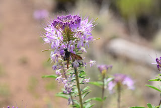 |
| Pollinators swarm around Rocky Mountain beeplants |
 |
| Pine sprouts grow among casualties of the Schultz Fire |
 |
| O'Leary Peak (right horizon) viewed from Brandis Trail |
 |
| Schultz Fire scar on eastern slopes of San Francisco Peaks |
 |
| Frothy Apache plume shrubs color the trail. |
Borne of
volcanism that began shaping the area millions of years ago, this mountainous parcel
in Northern Arizona is no stranger to fire. Whether brought on naturally by lighting
or lava or by human carelessness, fire drives uneasy cycles of destruction and
resurgence that’s aren’t going away anytime soon.
 |
| Brandis Trail access point |
Ten years
removed from the blaze, the area is in recovery mode, transitioning from what
had been a place of thick coniferous woodlands, alpine meadows and forested
foothills into a much different, starkly beautiful destination. The blaze
damaged several popular hiking trails including the Little Elden, Little Bear,
Sunset, Heart and parts of the Arizona Trail. But two outlier routes that suffered
the kind of odd, patchy damage to vegetation that melds islands of old growth
survivors with resurgent sprouts provide enlightening walking tours of an emerging
landscape.
 |
| Skunk bush--one of many blooming shrubs on the trail |
Even
before the fire, the Brandis and Deer Hill trails weren’t big-name attractions
but instead offered less crowded, easy treks at the base of San Francisco Mountain with no difficult climbs or confusing junctions. The Brandis Trail,
located at the edge of a residential area less than a mile from U.S. 89 north
of Flagstaff, wanders through the fire scar and is a good path to follow to see
how the forest is regenerating.
The 1.4-mile,
straight-shot route heads due west toward the peaks beginning with a short hike among
unscathed pines. Within a quarter mile, though, views of charred tree trunks that
hover precariously over acres toppled logs deliver a gut-punch to those who
recall the woodsy pre-fire environment.
The upside is that the near treeless terrain is now replete with
unobstructed views of nearby O’Leary Peak, a 8,916-foot lava dome volcano and Sunset Crater a young,
8,042-foot cinder cone and focal point of Sunset Crater Volcano National Monument.
Interestingly, the now dormant volcano turned tourist attraction was the source
of a curtain of fire that disrupted life here about 1,000 years ago.
Brandis
trail roughly traces a drainage gorge where resurgent shrubs, wildflowers and
saplings are encouraging signs of life regaining its hold. Healthy swaths of
silvery rabbitbrush, mountain gromwell, penstemons, Rocky Mountain beeplant and
Apache plume add color and sink stabilizing roots into the fragile soils while intermittent
stands of survivor pines, oaks and junipers stand in testimony to the sometimes
bizarre movements of wildfires. The
trail gets a little sketchy where it crosses the winding drainage several times.
To stay on track, know that at the crossings, the trail picks up directly on the
other side, not down the wash as random footprints might suggest.
At the
1.3-mile point, a livestock gate stands near one of the few shady areas on the
trail. Pass through (close it behind you) and continue on to the turnaround
point at the Deer Hill trail junction. For an optional, longer hike, the left
leg heads 4 miles south to connect with the Little Elden and Arizona Trail
while the right leg goes 1.5 miles north to its terminus at Schultz Pass Road.
 |
| The trail traces a scoured drainage |
 |
| A Yellow salsify flower gone to seed |
 |
| Yellow salsify is a common bloomer along the route |
LENGTH: 3 miles roundtrip (Brandis Trail only)
RATING:
easy
ELEVATION: 6,840 – 7,212 feet
GETTING
THERE:
From the
Interstate 17/40 interchange in Flagstaff, go east on I-40 to exit 201 for U.S.
89 north.
Continue
8.2 miles north on U.S. 89, turn left on Brandis Way and go 0.8-mile to a
parking apron at the corner of Brandis Way and Ostrich Lane. The trailhead is located at the end of a
fenced easement at the end of Brandis Way. Please respect private property in
the area by not blocking driveways or attempting to drive on the easement.
INFO:


