

 WOLF CREEK FALLS
Prescott
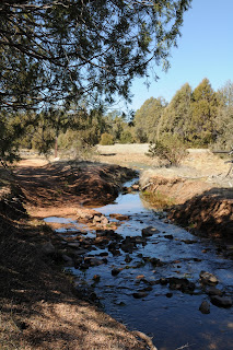
Wolf Creek is dry most of the year, but when winter snow on the Bradshaw Mountain peaks begins to melt, this waterway comes alive for a few weeks each year. Just before the creek dumps into the Hassayampa River, it tumbles through a narrow granite gorge spilling icy water over slick rock into drop pools 90 feet below the cliffs. A quarter-mile “waterfall alley” features two major falls as well as water chutes, natural dams and cascades.
HIKE DIRECTIONS: from the Groom Creek trailhead, hike across Senator Highway to the Horse Camp entrance. The hike begins at the “383” sign at the south side of the camp gate. From here, follow trail #383 (some of the signs say: 383/384) one mile to the junction for trail 384. Tricky spot: a fallen tree near the third 383/384 sign hides the path---the arrow on this sign points straight up and the bottom of the sign has been cut into a point. The correct trail is indeed straight ahead BEHIND the fallen tree; not off to the left or right. Beyond this point, keep an eye out for “384” signage to stay on track. After about 2.5 miles, the trail meets a wide dirt road (CR 101). Cross here and head toward the metal gate blocking a road heading steeply downhill---this is the continuation of trail 384, although you won’t see any signage until you reach Wolf Creek in 0.3 mile. Here, hop the creek, veer right and follow it to the falls. The upper falls are only about 0.1 mile in and are easy to get to while the lower falls can be seen at 0.4 mile but to get to them requires some scrambling and bush whacking. Once done exploring the falls, return the way you came OR complete the loop by following the 384 signs posted in a clearing above the falls.
LENGTH: 6 miles roundtrip to the falls and back OR 7.5 mile loop
RATING: moderate
ELEVATION: 6,200 – 5,600 feet
BEST SEASON: Year-round. The falls run best during spring snow melt (March-April) and after summer monsoon rains.
GETTING THERE:
From Phoenix, go north on I-17 to Cordes Junction. Exit onto SR 69 west and proceed through the towns of Mayer, Dewey and Prescott Valley to the town of Prescott. Continue on SR 69/Gurley Street through Prescott to Mt. Vernon Ave. Turn south (left) onto Mt. Vernon Ave. (which will turn into Senator Highway) and continue 6.4 miles to the Groom Creek Trailhead on the left. The hike begins across the road at the Horse Camp Gate. Roads are 100% paved.
DISTANCE FROM PHOENIX: 120 miles one-way.
INFO: Bradshaw Ranger District, Prescott National Forest, 928-771-4700
MORE PHOTOS: http://www.facebook.com/album.php?aid=51341&id=1795269672&l=191d4ba945


