Find A Trail. Start Your Search Here:

Showing posts with label Outer Limits Trail. Show all posts

Tuesday, March 15, 2022

Bottom Out - Roundabout Loop

BOTTOM OUT - ROUNDABOUT LOOP

A typical scene on the Bottom Out trail

Usually, getting to the good stuff takes effort.

The beginning of the Bottom Out trail is just an appetizer

This is especially true of hiking where the juiciest routes are often remote, tangential paths diverging from heavily traveled routes in popular outdoor destinations.
While many trail systems offer groomed and signed paths that range from super easy to difficult, the unpolished character of a place often resides at the raw end of the spectrum. 
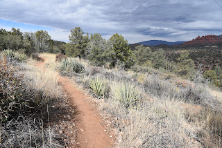
Easy going on the Roundabout trail

Sedona’s Western Gateway Area trail system builds on this theme with a

serpentine maze of interconnected loops that straddle a hilly pocket of Coconino National Forest on the far west side of town. But instead of its wild side being inaccessible to most, this system’s rough-cut gem spins off an easy trail less than a mile from a trailhead and appeals to hikers with a sense of adventure, experience and sturdy boots with good traction.

Bottom Out trail traces Dry Creek

The compact system of singletrack paths unwinds around the chiseled course of Dry Creek where the terrain shuffles among high ridgelines with epic vistas of Red Rock County’s iconic rock formations, fractured drainages, cypress and oak woodlands and sunny yucca-studded grasslands. Comprised of short, connecting segments, the trails don’t linger too long in any one ecozone. 

One of the many obstacles on the Bottom Out trail

A riparian zone in Dry Creek seen from Bottom Out trail

Instead, they soar over exposed ledges, dip into gullies and ramble through leafy riparian corridors in  seamless, smooth-moving cycles. 
Bottom Out trail dodges a gorge on Dry Creek

To sample the best of the system’s highs and lows in one swooping loop that runs through the system’s aforementioned raw end, try a circuit that uses the Bottom Out and Roundabout trails. These two trails reside in the system’s south central core just steps from the Cultural Park trailhead off State Route 89A. Finding the route is a bit confusing at first. Begin with a short walk on the Girdner trail, then head right onto the Outer Limits trail. Cross a dirt road and veer left to continue another 0.3-mile on Outer Limits to the Bottom Out junction. A wooden sign post points into a dry wash.  If the beginning a the Bottom Out trail looks sketchy—wait. That’s just an appetizer.
Girdner trail is used as a connector path on this circuit

The route is a veritable roller coaster of obstacles, down-climbs and stony passages.  Completely devoid of signage, the 1.3-mile trail is a joy for those who prefer less-travelled trails with a few baked-in challenges.  Rated difficult for hikers and very difficult for mountain bikers, the ragged route roughly traces Dry Creek, which usually lives up to its name. 
A slickrock passage on Bottom Out trail

It’s essential to pay attention to route-finding on this one where the trail dives deeper into the creek corridor. The trail is sometimes in the creek, sometimes on ledges above and sometimes slipping over slickrock, all the while crossing from bank-to-bank with no particular agenda.
Rock ledges on Roundabout trail

 
Bear Mountain viewed from Roundabout trail

The most fun parts of the trail are the rock jams and drop offs that must be worked around using creative route scouting. Mostly canyon-bound and shady, the Bottom Out trail delivers its deepest and final stony obstacle just before it exits the creek corridor and begins a short uphill crawl out of the sheer-walled canyon.  
Point where Bottom Out trail leaves the canyon

The mild climb ends back on the Girdner trail junction where views of the Cockscomb formation and Bear Mountain stand out to the north.  Each trail junction has an excellent map sign for customizing hikes. For this circuit, head right and follow Girdner 0.6-mile to the Roundabout trail.
Route-finding skills are needed on Bottom Out trail


The Roundabout leg of the hike is an easy-rated, entertaining muddling of tight bends and edgy traverses all backed by a carousel of changing views that include Mingus and Woodchute mountains, distinctive Capitol Butte and the long mesas of Wilson Mountain.  Sort of like an inside-out version of the Bottom Out trail, this 1.7-mile segment trades a viewless, cloistered obstacle course with an easy glide on open terrain with big mountain vista. 

There are no signs like this one on Bottom Out trail

And, unlike the hunt-and-peck nature of its companion, a clear path and excellent signage guide hikers home without a single obstacle in the way.

LENGTH: 4.1-mile loop (as described here)

RATING: moderate-difficult

ELEVATION: 4,154 - 4,492 feet

GETTING THERE:

Girdner-Cultural Park trailhead.

From the State Route 89A/179 traffic circle in Sedona, head 4.2 miles west (go left through the circle) on 89A to Cultural Park Way (traffic signal). Turn right and continue 0.3-mile to the Girdner Trailhead on the right. Trailhead has picnic tables and a map kiosk but no restrooms or water.

INFO:

https://www.fs.usda.gov/coconino/


Monday, March 16, 2020

Ground Control Trail

GROUND CONTROL TRAIL
Ground Control trail traces the cliffs below the Cockscomb
Kudos to whomever came up with the name for one of the newest trails in Sedona. The Ground Control trail, which opened in January 2020, delivers exactly what the aerial-themed moniker implies, lots of exposure and terrific fly-over views.
Fog covered Bear Mountain seen from Outer Limits trail
The compact but complex trail is located in the still-evolving, 29-mile Western Gateway Trails system that spins off from the old standard Girdner Trail in the Dry Creek area on the western edge of Sedona. The 0.7-mile Ground Control trail is situated in the middle of the system and can only be accessed by way of connecting routes. The quickest way to get to is from the north at the Aerie trailhead off Boynton Pass Road not far from the hyper-popular Bear Mountain and Doe Mountain trails. From this relatively under-the-radar trailhead, a 3.8-mile loop using the Cockscomb, Outer Limits and Ground Control trails gets to the good stuff post haste but also has options for building longer circuits.
Begin by hiking 1 mile on the Cockscomb trail then hang a right at the Ground Control junction.
Doe Mountain seen from Cockscomb trail
Agaves and cacti on the Cockscomb trail
Pinnacles of the Cockscomb formation on Ground Control
Blackfoot daisies bloom in sunny spots on the trails
Ground Control trail opened in January 2020
The freshly re-aligned single track was adapted by the forest service from a user-created bike route that traces on the edgy west face of the iconic Cockscomb rock formation. While the trail begins with an easy, twisting climb, its wonky character take hold once it reaches a deck-like passage of sandstone shelves.
Ground Control trail begins with a mild ascent
    
Lodged between the towering red rock escarpments of the Cockscomb and miles of open plains 300 feet below, the slick rock path hangs close to the brink and in places, walking the uneven exposed ledges mimics the rolls and bumps of a small aircraft flying through turbulence. 
Gregg's ceanothus is a common shrub on the route
Tight turns, abrupt down steps and glimpses of Sedona landmarks Capitol Butte and Courthouse Rock define the final quarter-mile of the trail that slips off the rocky flanks landing on calmer tread for the next leg of the hike. At the base of the Cockscomb formation, the route meets the Outer Limits trail. For the loop hike, head right. Otherwise, consult the trail maps posted at every junction to create a longer trip or car shuttle hike using the Cultural Park trailhead off State Route 89A.
View of Thunder Mtn (Capitol Butte) from Ground Control
Continue on the Outer Limits trail through beautiful high desert terrain accented with junipers, cypress, scrub oak, yuccas, cacti and acres of ocotillo. With its ample sunshine and watery drainages this 0.8-mile path is a productive destination for spring wildflower viewing in March and April.
Lots of ocotillo on the Outer Limits trail
Back at the Cockscomb junction, head left and retrace your steps back to the trailhead to complete the hike.
LENGTH: 3.8 mile loop
RATING: moderate
ELEVATION: 4,454 – 4,714 feet
GETTING THERE:
Aerie Trailhead (described here):
From the State Route 179/89A traffic circle in Sedona, head 3.2 miles west (left toward Cottonwood) on SR 89A to Dry Creek Road. Turn right and go 2.9 miles to Boynton Pass Road (FR152C), make a left and continue 1.5 miles to a “T” junction and veer left to stay on FR152C. Continue 1.4 miles to Aerie Road, turn left and go 0.4 mile to the turn off for the trailhead on the right.  There are no fees or facilities at the trailhead.
Cultural Park trailhead (optional south access):
From the State Route 179/89A traffic circle in Sedona, head 4.2 miles west on 89A Cultural Park Place on the right at the traffic signal. Go north 2.2 miles to the parking area. Follow the Outer Limits trail north to connect with Ground Control. There is a
picnic ramada and interpretive displays at the trailhead. No fees.

INFO:


Monday, September 16, 2019

WESTERN GATEWAY TRAILS


WESTERN GATEWAY TRAILS
Phase I trails of Western Gateway system opened spring 2019
Way back when, my grandfather kept his “church key” can opener tied to the cooler we’d take along on our fishing trips when I was a snot-nosed kid chasing frogs in Connecticut swamps. The simple strip of metal embossed with the Knickerbocker Beer logo got a workout on these outings—puncturing the lids of pre-flip-top-era beverage cans. When pull-tabs eliminated the need for the handy little tool, our tackle box staple rusted away on its cotton cord. Sometimes, we’d use it to scrape grit off our shoes.
Great Sedona views on the Western Gateway trails
The new trails wind through the Dry Creek drainage area
The distinctive puncture of the church key can opener
Big Sedona views on the Ledge-N-Airy Trail
It’s been more than 50 years since flat-top metal containers that required a church key opener went extinct in the mid 1960s, but in many places in Arizona’s backcountry, piles of these old-style food and beverage cans belie the locations of defunct ranch and mining encampments.  Determining the age and stories behind these sites is best left to professionals who use the distinctive triangular pierce mark of the church key as an index fossil of sorts in the science of can-ology.
View of Mingus Mountain from the Roundabout Trail.
Over the years, various antiquities acts designed to protect archeologically-significant resources on public lands have expanded to include objects as young as 50 years old.  So, although grandpa’s discarded beer cans were once trash, those that survived the elements are now historic artifacts.
Cockscomb formation, center horizon, visible from the trails
A few of these rusty relic sites are visible on the new Western Gateway Trail System in Sedona. Phase 1 of the proposed 30-mile system of fresh-cut, re-aligned and adopted user-created trails was completed earlier this year with the help of  Flagstaff-based American Conservation Experience trail crews and funding from various organizations. The twisted, interconnected trails wind though the hilly high desert that had been part of the old Girdner Ranch in the area around Dry Creek and its drainages.
Capitol Butte seen from the Outer Limits Trail
Centered around the old-standard Girdner Trail that begins north of State Route 89A near Sedona Cultural Park, several routes are finessed, signed and open for exploration. With fun names like Ledge-N-Airy, Outer Limits, Drano, Last Frontier and Roundabout, the singletrack routes offer additional access to a pocket of Coconino National Forest 4 miles west of Uptown Sedona.
Limestone escarpments on Ledge-N-Airy Trail
The new routes spin off from the Girdner and Centennial Trails and may also be accessed from the north at the Fay and Aerie trailheads along Boynton Pass Road.  For a moderate 4.6 mile hike, follow the Girdner Trail to the Outer Limits junction, veer left, pick up the Ledge-N-Airy trail and follow the signs to complete a loop. To see some of the rusty can artifacts, go right at the Outer Limits junction and step out on the Roundabout Trail. Within a half-mile, mounds of the now-protected camp litter are scattered among cacti and scrub oaks, dissolving into the red, dusty soil. As with all heritage sites, please do not disturb or remove anything.
Silverleaf nightshade berries on the Centennial Trail
If you are tempted to “clean up” the place, consider volunteering with an organization like Natural Restorations that will teach you how to differentiate trash from treasures and to remove refuge responsibly without disrupting the ecosystem or sensitive, protected relics. Phases II and III of the Western Gateway project are planned for the near future and are expected to be completed by 2021.
New trails spin off the Girdner & Centennial trails
Historic artifacts on the Roundabout Trail
Prickly pear fruits on the Girdner Trail
LENGTH: 4.6 miles  for the loop described here.
RATING: moderate
ELEVATION: 4440 – 4020 feet
GETTING THERE:
From the State Route 89A/179 traffic circle in Sedona, head 4.2 miles west (left thru the circle) on 89A to Cultural Park Way (traffic signal). Turn right and continue 0.3-mile to the Girdner Trailhead on the right. Trailhead has picnic tables and a map kiosk but no restrooms or water.

INFO & MAP:
COCONINO NATIONAL FOREST
To Volunteer or donate to the Western Gateway project:
SEDONA RED ROCK TRAIL FUND
To volunteer and learn about responsible trail clean-ups statewide:
NATURAL RESTORATIONS: