Find A Trail. Start Your Search Here:

Showing posts with label Arizona Trail Passage #31. Show all posts

Monday, July 18, 2022

Arizona Trail: Passage 31

ARIZONA NATIONAL SCENIC TRAIL: WALNUT CANYON PASSAGE 31

Gate on Passage 31 of the Arizona Trail

Shady and cool, Passage 31 of the Arizona National Scenic Trail is a satisfying respite from summer heat.  The 17.9-mile segment of the 800+-mile, state traversing route

drops off the plateau lakes region of Anderson Mesa and heads into pine-oak woodlands in Coconino National Forest southeast of Flagstaff.  Also known as the Walnut Canyon passage for its swing by the finger canyons and periphery of Walnut Canyon National Monument, this close-to-town segment of trail has several access points that make it perfect for day hikes, loop and car shuttle options. One trip to try goes from Marshall Lake to Sandy’s Canyon.

Greenery around Marshall Lake Tank

At the Marshall Lake trailhead, hikers get a reality check on the effects of drought.  While Marshall Lake is rarely more than a shallow, reed-choaked pond, this year, it’s bone dry.  Still, its elongated, pine-wrapped footprint is a picturesque sight and favorite grazing territory for elk.

Mountain vistas are meager, trees are major

The hike heads north from the large Arizona Trail sign along a well-defined and maintained singletrack.

Sign at Marshall Lake trailhead

 
Thick tree coverage and riffled terrain obscure big vistas, so this hike is more about immersing in the details of forest life. 
There are many ways to extend this Flagstaff hike

It’s a great place to smell “yellow belly” pines--older Ponderosa pine trees that have developed yellow-brown bark scales and emit a syrupy fragrance that’s often described as butterscotch, vanilla or cardamon. 
Marshall Lake was dry, July 2022

Each tree has a unique olfactory signature that blooms when warmed by the sun. 
Winged buckwheat blooms July - September

Go ahead and take a whiff, but be respectful. There’s no need to damage the bark to determine if the sap is sweet, savory or spicy.  
Hike may be extended into Sandy's Canyon


About 1.5 miles in, the green swale behind Marshall Mesa Tank appears below a set of easy switchbacks that lead into a shallow ravine.  The wildlife water hole is contained by an earthen dam, but, like the lake, it was dry, but lingering moisture feeds a fringe of wildflowers and elderberry trees.
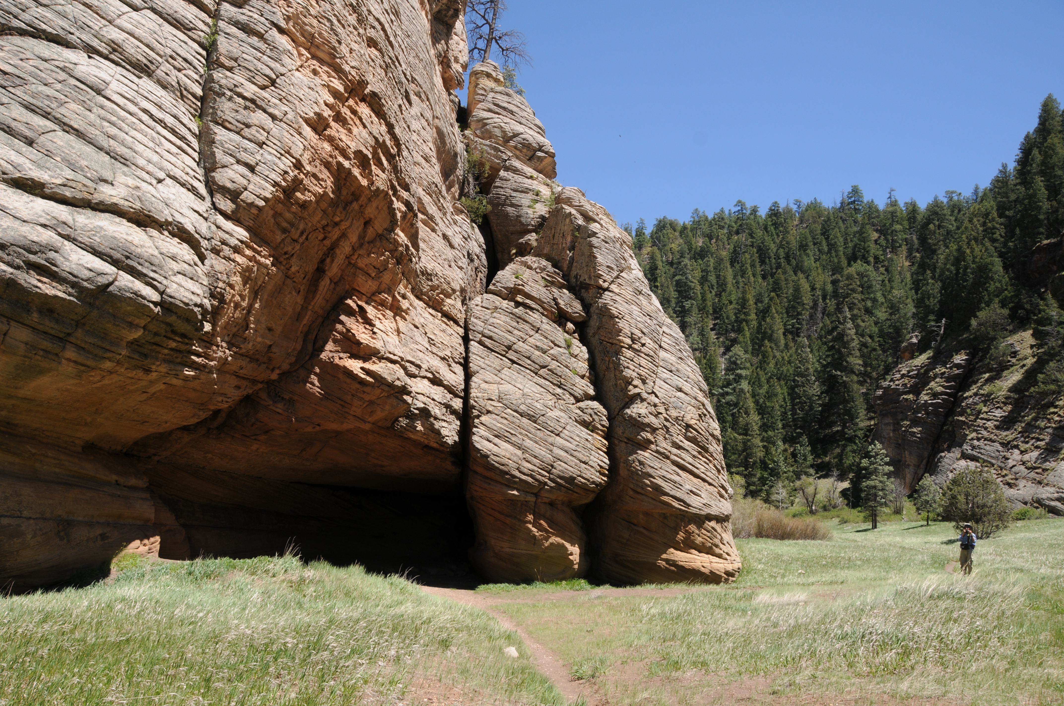
Limestone formations in Sandy's Canyon

Several more minor downhill twists lead to the junction with the Sandy’s Canyon trail. 

Yellow belly pines add olfactory notes to the hike

Here, the Arizona Trail veers right into the canyon where bizarre limestone formations are the key attractions on this very popular forest destination. For those who parked a shuttle vehicle at the Sandy’s Canyon trailhead, veer left at the junction and hike 1.5 miles for a 5.6 mile one-way trek.
Horned lizards are easy to spot on the ArizonaTrail

For a longer hike, Passage 31 continues north to Interstate 40 where it connects with the Elden Mountain Passage on the east side of Flagstaff. The trail also links up with the Flagstaff Urban Trails System and the Flagstaff Loop trail. Consult the Flagstaff city website for details on how to customize a hike circuit. Otherwise, just shit into reverse at the junction for an 8.2-mile out-and-back day hike.

LENGTH:

• 8.2 miles round trip, Marshall Lake trailhead to Sandy's Canyon junction and back.

• 17.9  miles one way for the entire segment.

• 5.6 miles one way for car shuttle.

RATING: moderate

ELEVATION: 6,885 – 7,185 feet as described here (6,500 – 7,185 feet for full passage)

GETTING THERE:

Marshall Lake trailhead:

From Flagstaff go 9 miles south on Lake Mary Road (County Road 3) to Forest Road 128 on the left, signed for Marshall Lake. Continue 2.2 miles on FR 128 (pass the observatory) to the Arizona Trail post at FR 128D, turn left and continue to the parking turnout at the large Arizona Trail sign.

Sandy’s Canyon trailhead:

From Flagstaff,  go 4.5 miles south on Lake Mary Road to the Sandys Canyon Trailhead on the left. Follow Sandy’s Canyon trail 1.5 miles to the Arizona Trail junction on the right.

INFO & MAPS:

Arizona Trail Association

Aztrail.org

Flagstaff Urban Trails System

https://www.flagstaff.az.gov/1379/Flagstaff-Urban-Trails-System-FUTS


Monday, May 6, 2019

WALNUT CANYON RIM

WALNUT CANYON RIM
Vista point on Passage 31 of the Arizona Trail
Arizona Trail Passage 31 runs for 17.9 miles between Marshall Lake and Interstate 40 southeast of Flagstaff.  Because it’s one of the shorter of the 43 passages that make up the 800-mile, state-traversing route, strong hikers can complete it in a day. Blasting through the entire section in a day makes for an epic trek, but numerous access points along the route provide ways to create abbreviated hikes that sample some of the most gorgeous slices of this high-country path.
Arizona valerian grow on moist slopes
The hike traces the rim of Walnut Canyon in Flagstaff
One to try begins at dirt parking apron along Old Walnut Canyon Road.
The moderate trek in Coconino National Forest links wildflower meadows, pine-oak woodlands, a dip into a tapered canyon and amazing vista points overlooking Walnut Canyon National Monument-- a 3600-acre site that protects archeological and natural resources--for a varied, moderate hike. 
The trek begins on a wide, flat path that weaves among pine groves and meadows with glimpses of antenna-cluttered Mount Elden (9298’) to the north.  
The rich soil and sun exposure foster acres of colorful wildflowers like stemless daisies, lupine and paintbrush.
At the 0.4-mile point, turn right at the Campbell Mesa Trails sign and continue on a mild uphill path. Just beyond a wildlife water hole, the trail meets a set of switchbacks carved from limestone escarpments that mitigate a descent along the canyon walls.  Hanging close to the edge, the slim trail passes among rock overhangs and clusters of yucca that cling precariously to cracks in the stony substrate. As the trail dives deeper into the canyon, enormous “yellow bellies” (mature Ponderosa pines that have developed a scaly, yellowish-brown bark) filter sunlight while rangy snags (dead, standing trees) attract insect-seeking birds and nesting critters. While passing through this enchanted forest, be sure to stop and smell the yellow bellies. 
A lupine about to bloom on the Arizona Trail
Their sap has an aroma that’s been described as butterscotch, vanilla and cherry. (My personal take on this fragrance is a top note of sugared cedar, a heart of moss and a base note of patchouli.)   In moist areas under the trees, look for tiny pink Arizona valerian flowers.  The tubular clusters can be seen poking out from blankets of pine needles through early summer.
Brilliant paintbrush are common bloomers along the AZT
Several spur paths lead to scenic points above Walnut Cny.
The short canyon section ends with a climb back up to the rim where the first vista point junction appears at 2.2-miles. To visit the scenic ledge, head left and hike the 0.2-mile spur to a promontory at the western edge of the national monument. Here, a fringe of conifers frame views of a heavily-forested bend in the meandering canyon. It’s a 300-foot drop from the breezy rim to the canyon floor with no guardrails to stymie a stumble.
Stemless daisies bloom in sunny meadows
So, explore carefully before retracing your steps back to the junction and continuing 1.1 mile on to the next vista detour where a 0.6-mile spur leads to more big sky panoramas and impressive canyon views. 
A pine shaded meadow along the route.
If you’re up for more, there are two more vista points before the trail moves off the rim.
Switchbacks mitigate a descent into the canyon
A wildlife water hole on the Arizona Trail
One is located another 1.1 miles down the trail while Fisher Point, the most famous of them all, marks the end of the tour 6.4 miles from the trailhead.
Stop and smell the yellow bellies
Yucca sprout from the craggy canyon walls
Limestone slabs and overhangs line the route
The trail hugs the canyon edge
LENGTH:
To the first vista point and back: 4.8 miles
To the second vista point and back: 7.8 miles
To Fisher Point and back: 12.8 miles
RATING: moderate
ELEVATION: 6613 - 6920 feet  to second vista point, (7033' to Fisher Point)
GETTING THERE:
From the Interstate 17/40 junction in Flagstaff, go 5.4 miles east on I 40 to exit 201 (Country Club Road). Turn right and  go 0.9-mile south to Old Walnut Canyon Road (Forest Road 303, turn left and continue 2.7 miles to the parking area on the right.
Snags (dead, standing trees) attract wildlife
The hike begins at the small Arizona Trail sign on the south side of the road. The last 0.3-mile is on rough dirt best suited for high-clearance vehicles.
INFO: Arizona Trail Association

Monday, August 3, 2015

WALNUT MEADOWS to WALNUT CANYON

WALNUT MEADOWS to WALNUT CANYON
Flagstaff
Rocky Mountain Bee Plant blooms June-September

Flagstaff's Campbell Mesa Trail System is an 11.3-mile maze of 5 loop routes. It's a popular hub for hiking, biking and horseback riding that wanders among pine-oak forests and open meadows north of Walnut Canyon National Monument. Located adjacent to residential communities on the east end of town, the system is a convenient launch site for casual day hikes, dog walks or more ambitious treks through and around the city. Excellent signage throughout and connectivity with the Arizona Trail and the Flagstaff Loop Trail makes for a wide variety of recreational opportunities. One way to sample the beauty of this area is to step out on the Walnut Meadows Trail, connect with Arizona Trail Passage #31 and hike to the edge of Walnut Canyon. The hike begins at the sign just south of the trailhead where it immediately enters a field of sunflowers then passes a Loop Trail post before ducking into the pines. At the 2.4-mile point, pick up the Arizona Trail, which roughly traces the canyon's ragged brim. Within a half-mile, you'll notice tributary gorges opening up on south side of the trail. Then, at the 4-mile mark, Walnut Canyon proper appears as a precipitous gash in the terrain. This makes for a good turnaround point. But, if you're up for a challenge, continue on as the route descends via steep, hairpin twists then climbs up again to make its way to Fisher Point and Sandy's Canyon.
LENGTH: 8 miles (as described here)
RATING: easy
ELEVATION: 6,363' - 6,882'
GETTING THERE:
From Phoenix, go north on Interstate 17 to the Interstate 40 junction in Flagstaff. Go east (toward Albuquerque) on I 40 to the Country Club Road exit 201. Turn right and go 1 mile south on Country Club Road to Old Walnut Canyon Road (Forest Road 303), turn left and continue 1 mile to the parking lot on the left. Trailhead is locate 300 feet beyond the gate.
Campbell Mesa Trail System
Arizona Trail Passage #31
MORE PHOTOS: