Find A Trail. Start Your Search Here:

Showing posts with label Granite Mountain Trailhead. Show all posts

Monday, March 9, 2026

Cow Poke Loop

COW POKE LOOP

Four Peks seen from 136th St. Express Trail

Besides the jaw-dropping views, amazing geology and lush Sonoran Desert vegetation, one of the best features of hiking in Scottsdale’s McDowell Sonoran Preserve is its trail connectivity.

Blackfoot Daisies

  Whether you’re up for a short trek with lots of company, a day-long haul through the preserve’s outer reaches or an easy loop away from the masses, the site’s 200+ miles of interconnected trails offers plenty of options
Boulder passage on the Bootlegger Trail

for customized hikes. Springtime is ostensibly when the preserve’s protected 30,500 acres of pristine desert habitat shines brightest. 
Bursage grows in sandy washes

It’s when balmy weather, clear skies and an abundance of colorful wildflowers, blooming shrubs and cacti add undiluted bliss to the trails.
Christmas cactus

A good recommendation for spring flower spotting that sidesteps the most heavily used routes is a loop hike using the parts of the Bootlegger, Granite Mountain Loop, Cow Poke, Dove Valley and 136th Street Express trails.
Coulter's lupine

  That might sound complicated, but signs placed at every junction coupled with available paper and digital maps, make getting around simple.
Cow Poke Trail

From the Granite Mountain trailhead on the preserve’s far east boundary.
All junctions are signed

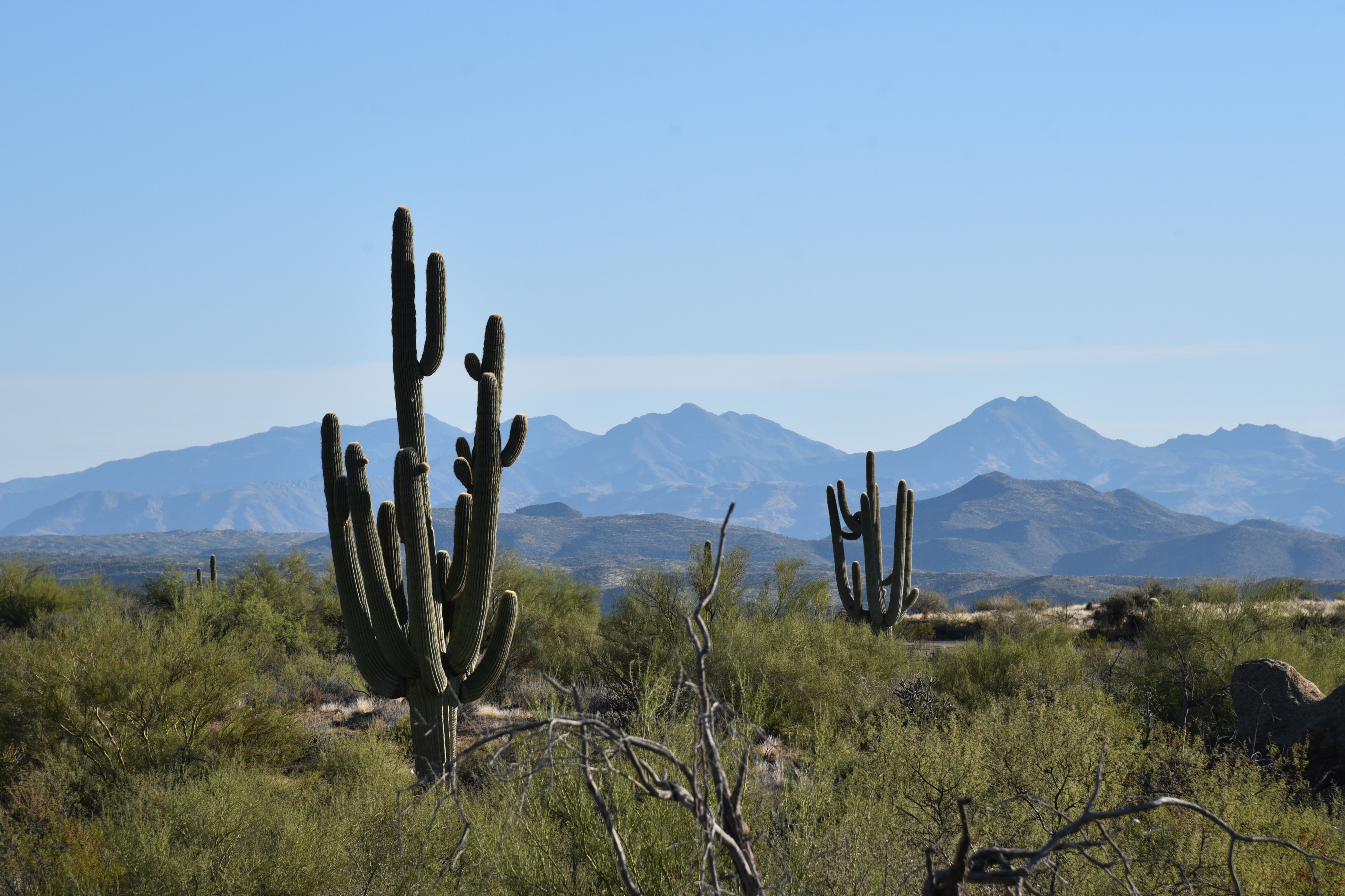
Head out on the Bootlegger Trail, which traipses through enormous rock formations and giant saguaros that frame views of the Salt River Valley and mountain peaks in Tonto National Forest.
Desert lavender

Desert hyacinth

At the GM4 junction, head right on the Granite Mountain Loop—for a twisty, undulating half-mile walk where drainages feed pockets of brittle bush, desert lavender, trixis, bursage, scorpionweed, hackberry, wolf berry, wishbone bush and fairy dusters. 
Rock formation on the Granite Mountain Loop

Desert marigold

About halfway through the Granite Mountain leg, a scenic viewpoint on a rocky knoll showcases vistas that stretch all the way to the Superstition Wilderness where the prominent silhouettes of Weaver’s Needle and the Flatiron stand out on the horizon.
Mexican gold poppies

At the GM5 junction, hang a right onto the Cow Poke trail. 
Owl clover

This 0.6-mile leg ditches the boulder-cluttered environ of the first half of the hike in favor of a more pastoral scene. 
trixis


Mostly flat and open to the sun, low-growing wildflowers thrive here.  Look for owl clover, Mexican gold poppies, Christmas cactus, Desert marigolds, Blackfoot daisies, and lupines.
Wishbone bush

At CP1, hang a right for a short walk on the wide, sandy Dove Valley trail before picking up the 136th St. Express trail for the final leg. The 136th Street Express is replete with yucca, cholla and Palo Verde trees. 
Wolfberry shrub

Views of the Four Peaks hover on the skyline to the east before the trail bends west for the walk back to the trailhead. 

LENGTH: 4.5 mile loop

RATING: easy

ELEVATION: 2,547 - 2,766 feet (374 feet of total elevation change)

GETTING THERE:

Granite Mountain Trailhead

31402 N. 136th Street, Scottsdale.

From Loop 101in Scottsdale, take the Pima/Princess exit #36 and do 6.5 miles north on Pima Road jot Dynamite Blvd/Rio Verde Dr.  Turn right and go k5.9 miles to 136th St., turn left and continue 1.8 miles to the trailhead entrance on the left.

Preserve hours are sunrise to sunset daily. 

INFO: https://www.scottsdaleaz.gov/preserve


Monday, October 24, 2022

On the Suburban-Wildland Interface: 136th Street Trail

136th STREET EXPRESS TRAIL

Saddle Mountain (right horizon) seen from 136th St. Trail

People suck.  It seems this barb gets spit out by hikers more so than by any other category of humans. The misanthropic affront appears on t-shirts, stickers and hats, the wearers oblivious to the irony.

Tonto National Forest mountains on horizon

While I don’t presume to know what’s going on in the heads of hikers who hate people, I kind of understand why they feel that way.

Saguaros clutter at the base of Granite Mountain

 Trail overcrowding, trash, graffiti, suburban sprawl, noisy groups and the guy who overdosed on Bleu de Chanel cologne is enough to drive anyone over the edge.  While cathartic, an all-purpose vent is like a self-fulfilling prophesy.  Embrace negativity, and that’s what you’ll get.
Bee gathers pollen on a turpentine bush

While the world does host a fair number of certifiable boneheads, most people are alright. Take for instance the people who invented stuff like the wheel, light bulbs, life-saving medical procedures, and beer. Also, there are people who dedicate themselves to the land preservation, fundraising, grant writing, education, sustainability and trail building and maintenance-- causes that hikers rely on to get away from the perceived enemy.

Four Peaks seen from the trail

Hikers--all is not lost because the alright people take the high road and do the grunt work of fixing the malfeasance of the few. Want an example of a people-powered success story? Take a hike on the 136th Street Express Trail in Scottsdale’s McDowell Sonoran Preserve.

A cardinal serenades from a tree snag

Located on the eastern edge of the preserve’s north region, the easy trail marks the divide between pristine desert and a growing suburban footprint.  The permanently-protected large north Valley desert habitat has over 200 miles of non-motorized trails and is the result of grassroots (people)  efforts and the City of Scottsdale’s (people) recognition of the value of retaining open space for recreational purposes.

People will always need places to live, transportation, food, and water, and certainly the means to these ends can be contentious.

Antennae cluttered Mount Ord on left horizon

Until we can master a perfect society and negative-impact living, we compromise. A walk on the 136th Street Express Trail reveals how, in an imperfect world, that is done.
Desert hackberry trees thrive near washes

Running parallel to the hilly, paved course of 136th Street, the singletrack dirt path debarks from the Granite Mountain Trailhead. Heading due north, the route passes among gorgeous specimens of yucca, cholla, desert shrubs and giant saguaros.
 
The massive form of Granite Mountain stands to the west of the trail, its slopes spilling boulders and weathered stone chips into sandy washes that splay the terrain and feed green ribbons of water-loving desert hackberry, mesquite and palo verde trees.  

Mountain vistas emerge as the trail makes a barely-noticeable uphill crawl to its northern terminus near the border of Tonto National Forest. 

Skyline of the Superstition Wilderness area

Cholla frame mountain vistas on the trail

Across the rooftops of ranch homes and barns along 136th Street, the distinctive silhouettes of Four Peaks, Saddle Mountain, Mount Ord and the iconic spire of Weavers Needle and the Flatiron stand out from their protected homes in the national forest and the Mazatzal, Four Peaks and Superstition Wilderness areas that were all designated by, you guessed it—people.

So, instead of wallowing in negativity and hiding behind a snarky t-shirt, how about trying a proactive approach. Maybe volunteer for a conservation organization.

Tom's Thumb (right horizon) in McDowell Mountains

Gloria Steinem summed it up best when she said,

“So do not allow anyone to take away your hope or your laughter. It is an imagination of the positive that is the first step toward creating it.”

Might make a great t-shirt. 

TO VOLUNTEER

McDowell Sonoran Conservancy

Education, Stewardship, Events, Trail Maintenance

https://www.mcdowellsonoran.org


Maricopa Trail

Trail Maintenance, Events

https://mctpf.org


Natural Restorations

Clean Up Events

http://www.naturalrestorations.org


Arizona Trail

Education, Stewardship, Events, Trail Maintenance

https://aztrail.org/events/

The trail crosses Old Paint Wash


LENGTH: 8.2 miles round trip (out-and-back hike)

RATING: easy-moderate

ELEVATION: 2,570 - 2,696 feet

GETTING THERE:

Granite Mountain Trailhead,

31402 N 136th St., Scottsdale.

HOURS: generally sunrise to sunset daily

FACILITIES: restrooms, shade ramada, interpretive signs

INFO & MAPS:

City of Scottsdale

https://www.scottsdaleaz.gov/preserve


Monday, February 29, 2016

BOOTLEGGER LOOP

WILDFLOWERS on the BOOTLEGGER TRAIL
McDowell Sonoran Preserve, Scottsdale
Bootlegger Trail

Despite abundant winter rains and mild temperatures that raised our expectations for a banner wildflower season, this year's showing of desert blooms has turned out to be a more low-key event. The hype may have fizzled, but there are still plenty of flowering plants to enjoy along Valley trails.
One of the best places to observe a wide variety of specimens is in the far east side of the McDowell Sonoran Preserve. In this area of desert, wildflowers thrive best among boulder outcroppings on the flanks of Granite Mountain
where precious bits of shade and trapped moisture nurse blooms to fruition. When the elements dole out perfect measures of rain, warmth and sunlight, poppies and lupines paint the desert floor in blazing shades of purple and orange. This spectacular but rare event is beautiful to behold but, there's also joy in spotting a lone poppy or colorful patch of brittlebush during less productive seasons.
On a recent hike along the Bootlegger Trail, I compiled a list of wildflowers we observed. There were many bloomers, but you'll have to stay alert to see them. Are you up for a scavenger hunt? Here's a partial list. Happy hunting!
1. Lacepod
2. Mexican Gold Poppy
3. Desert Chicory
4. Desert Wishbone
5. Desert Rock Pea
6. Scorpionweed
7. Filaree (Stork's Bill)
8. Desert Lavender
9. Popcorn Flower
10. Fiddleneck
THE HIKE:
From the Granite Mountain Trailhead, hike 1.3 miles on Bootlegger Trail. Head right on Granite Mountain Loop and continue 1.1 miles to Coyote Canyon Trail. Turn right and hike 1.3 miles (note the crested saguaro at the 0.8-mile point) to Dove Valley Trail. Veer right and go 1 mile to 136th St. Express and follow it 1.3 miles back to the trailhead.
LENGTH: 6-mile loop
RATING: easy
ELEVATION: 2,415' – 2,822'
GETTING THERE:
Granite Mountain Trailhead, 31402 N. 136th St. Scottsdale.
From Loop 101 in Scottsdale, take the Princess/Pima exit #36 and go 6.5 miles north on Pima to Dynamite Blvd./Rio Verde Dr. Turn right and continue 5.9 miles to 136th St., turn left and go 1.8 miles to the trailhead on the left. Trailhead is open sunrise to sunset. No facilities.
INFO & MAPS: McDowell Sonoran Preserve
MORE PHOTOS:

Monday, April 27, 2015

COYOTE CANYON

COYOTE CANYON
McDowell Sonoran Preserve
Crested saguaro on Coyote Canyon Trail

The next phase of trail development in Scottsdale's McDowell Sonoran Preserve is underway. Repurposing of existing social paths and new construction in the far north corridor that stretches from Dove Valley Road to the border of Tonto National Forest will continue through 2016. Several fresh routes have already been opened including the Coyote Canyon Trail which is already becoming a hiker favorite because of its unique features. In addition to see-forever views of the Cave Creek
Mountains and Verde River Valley, the route has two signature attractions--- a granite-walled slot canyon and a gloriously gnarled crested saguaro. Since this trail is deep-baked into the heart of the preserve, the only way to get to it is by hiking along connecting routes.
Inside the mini box canyon
Until additional legal parking areas are established, the trail must be accessed from the Granite Mountain trailhead. Here's the most direct circuit. Follow the 136th Street Express 1.3 miles north and turn left onto the Dove Valley Trail. Hike 0.9 mile to the Coyote Canyon Trail junction veer left and trek 1.3 miles to where it ends at the Granite Mountain Loop Trail. From here, there are many options for your return route (download the preserve map for details) but the shortest way back to the trailhead is to turn turn left and go 0.5 mile to the Cow Poke Trail, follow it 0.6 mile back to Dove Mountain Trail and return the way you came.
LENGTH: 6.2 miles (as described here)
RATING: easy
ELEVATION: 2,580' – 2,840'
Entrance to the box canyon
GETTING THERE:
Granite Mountain Trailhead, 31402 N. 136th St. Scottsdale.
From Loop 101 in Scottsdale, take the Princess/Pima exit #36 and go 6.5 miles north on Pima to Dynamite Blvd./Rio Verde Dr.  Turn right and continue 5.9 miles to 136th St., turn left and go 1.8 miles to the trailhead on the left. Trailhead is open sunrise to sunset.  No facilities.
INFO:
MORE PHOTOS:

Thursday, December 5, 2013

BOOTLEGGER-GRANITE MOUNTAIN LOOP


BOOTLEGGER-GRANITE MOUNTAIN LOOP
McDowell Sonoran Preserve

Just a few odometer clicks and 1000 feet in elevation north of downtown Phoenix, is a desert rangeland with enough fresh air and open space to expunge the mind-numbing pressures of city living.  Here, a 6-mile trail around 3526' Granite Mountain transports hikers through a rugged habitat of survivalist native creatures and landforms.  There's little moderation here.   Summer heat is brutal, it freezes in winter and the area's 12" of annual rainfall arrives in episodic lusty torrents that turn bone dry washes and
Sculpted granite
canyons into raging rivers within minutes. But for a few months between the extremes, this desert preserve is a balmy, blooming paradise. The best time to hike here is from late October through early May, when temperatures are mild and wildflowers color the land like splattered paint. Hikers will get a kick out of the acres of granite masses scoured into fanciful forms by eons of geological calamity. As unforgiving elements peck away, molecule-by-molecule, the rock erodes into the embodiments of giant mushrooms, dragons, serpents and goblins. One hiker saw the profile of the Quaker Oats guy. Whatever image the nature-whittled granite conjures is a personal journey.
Although there are more direct routes to connect with this loop, going by way of Bootlegger Trail exposes hikers to some exceptional geological jumbles such as narrow passages and cave-like enclaves that would have made handy hooch hideouts for brewers evading prohibition patrols.
To take this trip, begin on Bootlegger trail and hike 0.7 mile to Saddlehorn Trail.  Follow Saddlehorn 0.2 mile (can you spot the eponymous rock formation?) and connect with Granite Mountain Loop.

LENGTH: 6-mile loop
RATING: moderate
ELEVATION: 2570' - 2780'
HOURS: trails are open sunrise to sunset
GETTING THERE:
Granite Mountain Trailhead, 31402 N. 136th St. Scottsdale. From Loop 101 in Scottsdale, take the Princess/Pima exit 36 and go 6.5 mile north on Pima to Dynamite Blvd./Rio Verde Dr.  Turn right and continue 5.9 miles to 136th St., turn left and go 1.8 miles to the trailhead on the left.
No facilities.
INFO:

Saturday, November 30, 2013

BALANCED ROCK TRAIL


BALANCED ROCK TRAIL
McDowell Sonoran Preserve

Balanced Rock

Even in a terrain replete with natural sandblasted granite sculptures, Balanced Rock stands out.  Located in the heart of the newly opened Brown’s Ranch cluster of trails, this massive mushroom-shaped behemoth stands tall and precariously exposed atop a weathered slab of igneous stone. Flanked by a complement of lesser boulders and a wind-tortured juniper, the hows and whys of the monolith’s predicament are fodder for inquisitive minds.  The path to the rock is a short detour easily accessible via connecting trails. Although it is popular as a side trip off longer loop treks, the rock can be reached most directly by hiking 1.2 miles on Powerline Road to the Balance Rock Trail junction.  From here, it’s 0.9-mile to the rock and 1.6 miles to trail’s end. A map at the trailhead shows other hike combinations. 

Balanced Rock Trail

LENGTH: 5.6 miles roundtrip (or 4.2 to the rock and back)
RATING: easy
ELEVATION: 2570’ – 2646’
GETTING THERE: Granite Mountain Trailhead, 31402 N. 136th St. Scottsdale.
From Loop 101 in Scottsdale, take the Princess/Pima exit #36 and go 6.5 miles north on Pima to Dynamite Blvd./Rio Verde Dr.  Turn right and continue 5.9 miles to 136th St., turn left and go 1.8 miles to the trailhead on the left. Trailhead is open sunrise to sunset.  No facilities.
INFO & MAPS: McDowell Sonoran Preserve
MORE PHOTOS: