Find A Trail. Start Your Search Here:

Showing posts with label Walnut Canyon. Show all posts

Monday, July 18, 2022

Arizona Trail: Passage 31

ARIZONA NATIONAL SCENIC TRAIL: WALNUT CANYON PASSAGE 31

Gate on Passage 31 of the Arizona Trail

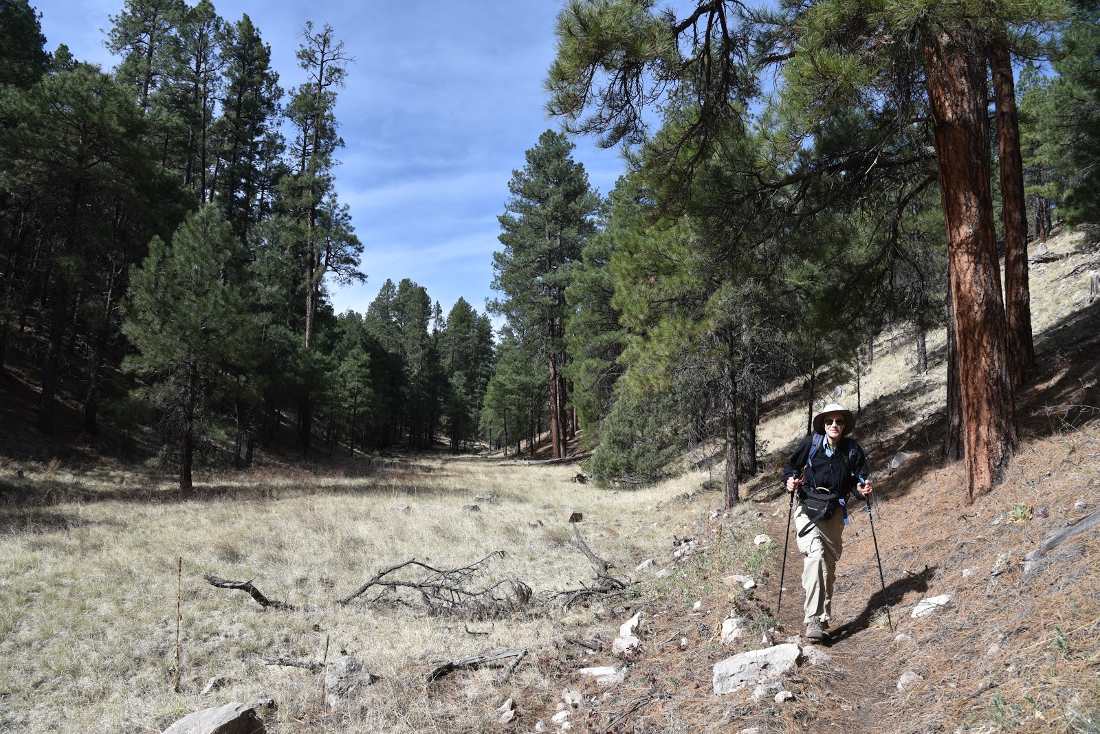
Shady and cool, Passage 31 of the Arizona National Scenic Trail is a satisfying respite from summer heat.  The 17.9-mile segment of the 800+-mile, state traversing route

drops off the plateau lakes region of Anderson Mesa and heads into pine-oak woodlands in Coconino National Forest southeast of Flagstaff.  Also known as the Walnut Canyon passage for its swing by the finger canyons and periphery of Walnut Canyon National Monument, this close-to-town segment of trail has several access points that make it perfect for day hikes, loop and car shuttle options. One trip to try goes from Marshall Lake to Sandy’s Canyon.

Greenery around Marshall Lake Tank

At the Marshall Lake trailhead, hikers get a reality check on the effects of drought.  While Marshall Lake is rarely more than a shallow, reed-choaked pond, this year, it’s bone dry.  Still, its elongated, pine-wrapped footprint is a picturesque sight and favorite grazing territory for elk.

Mountain vistas are meager, trees are major

The hike heads north from the large Arizona Trail sign along a well-defined and maintained singletrack.

Sign at Marshall Lake trailhead

 
Thick tree coverage and riffled terrain obscure big vistas, so this hike is more about immersing in the details of forest life. 
There are many ways to extend this Flagstaff hike

It’s a great place to smell “yellow belly” pines--older Ponderosa pine trees that have developed yellow-brown bark scales and emit a syrupy fragrance that’s often described as butterscotch, vanilla or cardamon. 
Marshall Lake was dry, July 2022

Each tree has a unique olfactory signature that blooms when warmed by the sun. 
Winged buckwheat blooms July - September

Go ahead and take a whiff, but be respectful. There’s no need to damage the bark to determine if the sap is sweet, savory or spicy.  
Hike may be extended into Sandy's Canyon


About 1.5 miles in, the green swale behind Marshall Mesa Tank appears below a set of easy switchbacks that lead into a shallow ravine.  The wildlife water hole is contained by an earthen dam, but, like the lake, it was dry, but lingering moisture feeds a fringe of wildflowers and elderberry trees.

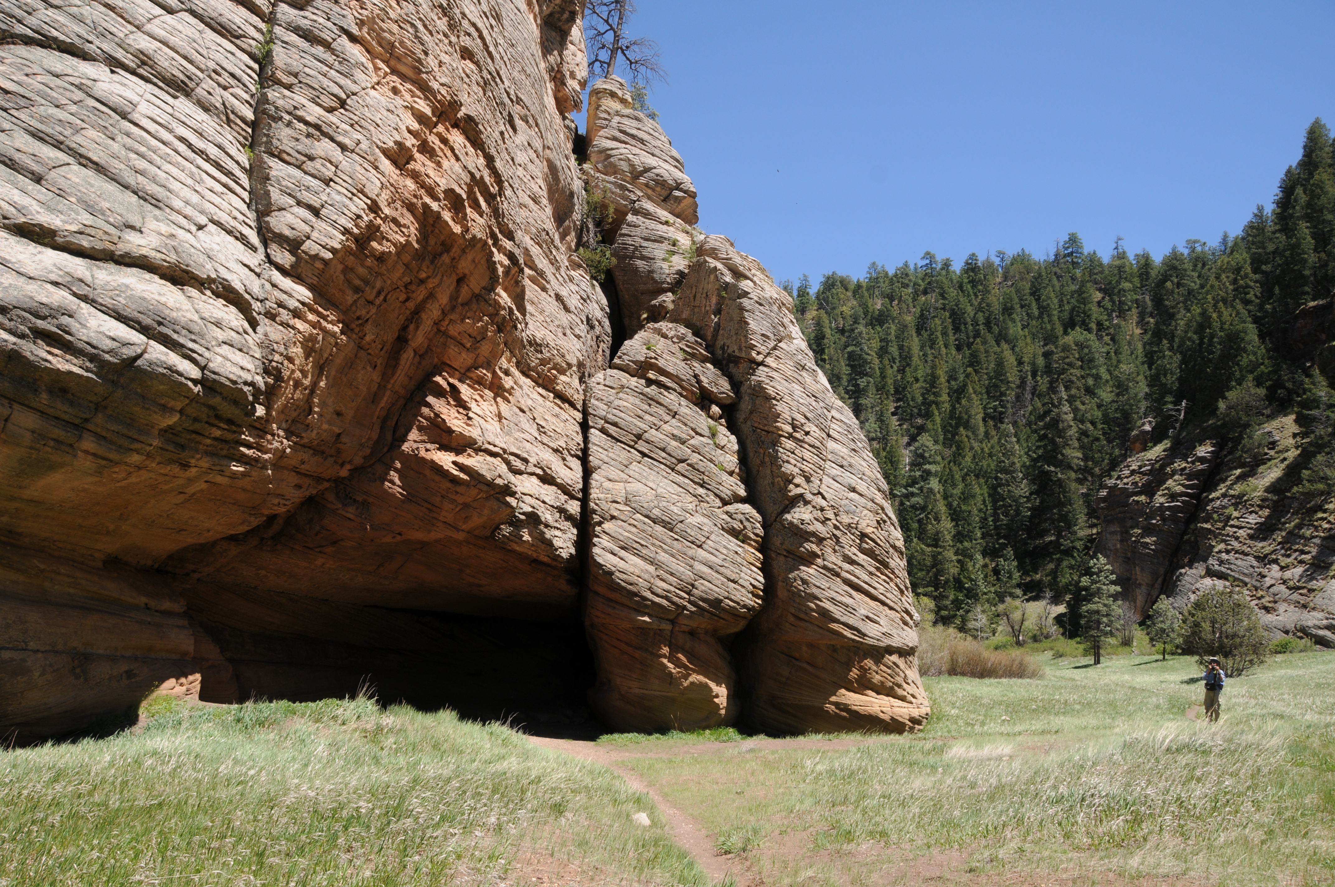
Limestone formations in Sandy's Canyon

Several more minor downhill twists lead to the junction with the Sandy’s Canyon trail. 

Yellow belly pines add olfactory notes to the hike

Here, the Arizona Trail veers right into the canyon where bizarre limestone formations are the key attractions on this very popular forest destination. For those who parked a shuttle vehicle at the Sandy’s Canyon trailhead, veer left at the junction and hike 1.5 miles for a 5.6 mile one-way trek.
Horned lizards are easy to spot on the ArizonaTrail

For a longer hike, Passage 31 continues north to Interstate 40 where it connects with the Elden Mountain Passage on the east side of Flagstaff. The trail also links up with the Flagstaff Urban Trails System and the Flagstaff Loop trail. Consult the Flagstaff city website for details on how to customize a hike circuit. Otherwise, just shit into reverse at the junction for an 8.2-mile out-and-back day hike.

LENGTH:

• 8.2 miles round trip, Marshall Lake trailhead to Sandy's Canyon junction and back.

• 17.9  miles one way for the entire segment.

• 5.6 miles one way for car shuttle.

RATING: moderate

ELEVATION: 6,885 – 7,185 feet as described here (6,500 – 7,185 feet for full passage)

GETTING THERE:

Marshall Lake trailhead:

From Flagstaff go 9 miles south on Lake Mary Road (County Road 3) to Forest Road 128 on the left, signed for Marshall Lake. Continue 2.2 miles on FR 128 (pass the observatory) to the Arizona Trail post at FR 128D, turn left and continue to the parking turnout at the large Arizona Trail sign.

Sandy’s Canyon trailhead:

From Flagstaff,  go 4.5 miles south on Lake Mary Road to the Sandys Canyon Trailhead on the left. Follow Sandy’s Canyon trail 1.5 miles to the Arizona Trail junction on the right.

INFO & MAPS:

Arizona Trail Association

Aztrail.org

Flagstaff Urban Trails System

https://www.flagstaff.az.gov/1379/Flagstaff-Urban-Trails-System-FUTS


Wednesday, July 4, 2018

WALNUT CANYON NATIONAL MONUMENT

Cultural Heritage Hikes at Walnut Canyon National Monument
View from a "shady side" dwelling
Walnut Canyon is one of Northern Arizona’s most fascinating natural wonders.  Over its 20-mile course, the 400-foot-deep gorge cuts through pine-studded plateaus and eons of Earth’s history.  
Sinagua cliff dwellings
Located just a few miles southeast of Flagstaff, the chasm’s wavy course was created over millions of years by a complicated series of geological events. The canyon’s tilted layer-cake appearance is partly made up of eroded limestone deposits and the lithified remains of ancient coastal sand dunes. 
Edible mahonia (barberry) also has medicinal qualities.
Although you’d need a Ph.D. to thoroughly understand its geological anatomy, the canyon’s more relatable human element is the focus of a hike along the trails of Walnut Canyon National Monument. 
240 stairs descend to the Island Trail
The park was established in 1915 to protect and preserve the cultural artifacts of the Sinagua people who built and occupied cliff dwellings in the canyon’s ledges and shallow caves between 1100-1250.  Two educational hikes offer lessons in biodiversity, geology, traditional farming methods and human history.  The Island Trail begins with a steep, 185-foot descent on a stone staircase with dizzying views. The trail swings around a rock jetty where dozens of stone-and-mortar rooms are built into crags and overhangs. Interpretive signs provide information about the structures as well as native plants and animals. 
View of Walnut Canyon from the Rim Trail
Dwellings on the Island Trail
The west or “shady side” of the jetty is smothered in towering Douglas firs, ponderosa pines, mahonia and Arizona walnut trees that thrive in the cooler, wetter microclimate.  Around the bend, the path emerges onto the “sunny side” -- an exposed ledge where the plant life reflects dryer, warmer conditions. Cacti, yucca and pinion pine cling to chiseled escarpments.  From here, views of the visitor center high above, reminds that there’s a strenuous 240-step climb out to get to the next trail.  
Pueblo on the Rim Trail
Back up on the brow of the gorge, the Rim Trail makes an easy half-mile loop to scenic overlooks, a pit house, pueblo and demonstration garden. Once done with the hikes, stop by the visitor center to augment your experience by viewing displays of archeological finds and a beautiful video about the area’s natural history.
Stairs descend 185 feet to the Island Trail
LENGTH:
Island Trail: 1-mile roundtrip
Rim Trail:  0.7-mile roundtrip
RATING:

Island Trail: difficult
Rim Trail: easy, partially paved.
ELEVATION: 6690 – 6505 feet
GETTING THERE:
From the Interstate 17/40 intersection in Flagstaff, go 7.5 miles east on I-40 to exit 204, turn right and continue 3 miles to the site.  There is an entrance fee.
NOTE:  Temporary closures of the Island Trail may be implemented during fire season when red flag warnings are issued by the National Weather Service.
INFO:

Monday, April 30, 2018

FLAGSTAFF'S FAY CANYON

FLAGSTAFF'S FAY CANYON
Fay Canyon
Not to be confused with the Fay Canyon Trail in Sedona, Flagstaff’s version is a totally different experience. The meandering trail that follows the course of a gully that feeds into majestic Walnut Canyon southeast of town is a mellow, woodsy walk.  Located just east of the heavily-traveled Sandy’s Canyon trail off Lake Mary Road, the Fay Canyon route is a quieter trek with similar qualities.  
Creeping Barberry
The unsigned route is a little tricky to follow. Hike up Forest Road 9477B to the 0.3-mile point, veer left at a gate and pick up a single track heading north.  For reference, there’s a sign warning of heavy horse traffic a few yards down the trail. 
A ravine bisects Fay Canyon
Within a short distance, the trail makes a sharp turn to the right and begins a downhill plunge on long switchbacks.  This piney segment decends on an easy grade to emerge in at the head of the canyon.  Over the next two miles, the gorge gradually transforms from a steep-walled sliver to a gaping valley. Bisected by a water-scoured ravine, the canyon has horse trails on both banks. These can be confusing, but they eventually merge. Just keep heading north and you’ll be fine. 
Arizona valerian
Along its expanding course, the trail passes by pockmarked limestone cliffs, rock shelves and shallow caves.
Fay Canyon
A closer look at the limestone reveals crystal-filled geodes, entrenched fossils and glinting quartz nodules. 
Tiny crystals in limestone
In moister areas beneath the mixed conifer canopy, an understory of thorny-stemmed wild roses, gooseberries and willows grow in profusion among clumpy grasses and patches of creeping barberry, Arizona valerian and daisies galore.
At the 2.6-mile point, the trail ends in an airy meadow where the Arizona Trail passes through. 
Lizards are easy to spot in Fay Canyon
This is the turnaround point for an out-an-back hike, however, trail signs show distances for continuing to the Flagstaff Urban Trails System, Marshall Lake or Fisher Point.  One fun option is to make the short, but steep walk up to Fisher Point. Known for wild winds that churn up speed as they funnel through a network of forested gorges, the area surrounding Fisher Point is a fascinating enclave of contorted rock formations softened by wildflower fields and swaying pines. 
Dunes beneath Fisher Point
To get to the lookout point 400 feet above the major trail junction, follow the signs 1.2-miles and enjoy the breezy vistas. 
Wild rose
View from Fisher Point
LENGTH: 2.6 miles one-way for Fay Canyon, or 8.2 miles round trip with Fisher Point option.
RATING: moderate
ELEVATION: Fay Canyon : 6,620'-6,950' or 7,033' to Fisher Point
GETTING THERE:
From Flagstaff, go 4 miles south on Lake Mary Road to S. Wildlife Road (at the “Hitching Post Stables” sign).  Turn left and drive a few yards to a “T” intersection, veer left and continue less than 0.1 mile to the sign that reads Walnut-Skunk-Fay Closure Area, No Motor Vehicles.  Parking is very limited.  Please respect private property in the area by not blocking roads or driveways.

Monday, May 15, 2017

WALNUT CANYON TRAIL

WALNUT CANYON TRAIL
Walnut Canyon Trail
Flagstaff’s Walnut Canyon, which splits the landscape southeast of town, is the work of an ancient river that carved its way through dolomite-rich limestone and sandstone.  The geological wonder is rife with history and recreational opportunities. Think prehistoric Sinagua dwellings at Walnut Canyon National Monument, that grueling staircase, hikes along the rim and a scenic passage of the Arizona Trail. As if these attractions weren’t enough, there’s another place tucked into a tributary at the canyon’s western edge that explores its wilder side. To get to this surprisingly green destination, begin on the popular Sandys Canyon Trail, hike two miles through the wide, pine-fringed valley to the equestrian bypass post and veer right heading toward a hub of signs and activity where the Arizona Trail branches into various options for hiking and riding through or around Flagstaff.
Petrified sand dunes on Walnut Canyon Trail
Just around a bend, first glimpses of the petrified sand dunes that characterize the trail stand out in a massive blob of cross-bedded stone. The appearance of the landmark below Fisher Point can be described as having the shape of Star Wars villain Jabba the Hutt and the texture of dinosaur hide. Because Jabba did his dirty deeds a long time ago in a galaxy far, far away we cannot be sure of when he lived, however, we know for sure that Walnut Canyon’s odd geological features are older than the dinosaurs of our own little planet.  The sand dunes formed between 299 and 251 million years ago during the Permian Age when earth’s land masses were coalescing into the super continent of Pangaea. This was a period of climate extremes and harsh conditions.
Cave along Sandys Canyon Trail
This domain of reptiles and other species that would later evolve into mammals ended with a mass extinction of terrestrial and sea species. What happened? Well, theories include climate change due to volcanic eruptions, methane poisoning and asteroid impacts.  Death Star, maybe?
Regardless, the fossil remains of that time form the backbone of a fascinating hike. From the sign post hub, hike over to the “Jabba” formation to explore the cave at its base. At the back of the cavern, look for a slot that lets in a sliver of sunlight.
Cave entry on Walnut Canyon Trail
After checking out the cave, continue east along and unmarked trail to a sign that marks the beginning of the Walnut Canyon Trail. Beyond the sign, the canyon tapers into a tunnel of oaks and willows with an understory of Red-osier dogwood and scratchy brambles. Canyon walls tower 400 feet on both sides as the thin trail plows through damp aspen woodlands, mossy pines and sun-washed meadows.
Jabba the Hutt?
Along the way, two spur paths lead to caves scoured from striated limestone walls. The first is just a shallow overhang while the second is a deep shaft with water seeping from above. Bring a flashlight for this one because it goes back about 25 dark, dank feet. 
The trail goes on to a point roughly 1.8 miles from the Jabba cave where an overgrown drainage and an impenetrable nursery of aspen saplings deny further passage.
Oaks on Walnut Canyon Trail
LENGTH: 8 miles roundtrip
RATING: moderate
ELEVATION: 6820’ – 6580’
GETTING THERE:
From Interstate 17 in Flagstaff, take the Lake Mary Road exit 339 and go 4.5 miles south to the Sandys Canyon Trailhead turnoff on the left.
INFO: Coconino National Forest

Monday, August 3, 2015

WALNUT MEADOWS to WALNUT CANYON

WALNUT MEADOWS to WALNUT CANYON
Flagstaff
Rocky Mountain Bee Plant blooms June-September

Flagstaff's Campbell Mesa Trail System is an 11.3-mile maze of 5 loop routes. It's a popular hub for hiking, biking and horseback riding that wanders among pine-oak forests and open meadows north of Walnut Canyon National Monument. Located adjacent to residential communities on the east end of town, the system is a convenient launch site for casual day hikes, dog walks or more ambitious treks through and around the city. Excellent signage throughout and connectivity with the Arizona Trail and the Flagstaff Loop Trail makes for a wide variety of recreational opportunities. One way to sample the beauty of this area is to step out on the Walnut Meadows Trail, connect with Arizona Trail Passage #31 and hike to the edge of Walnut Canyon. The hike begins at the sign just south of the trailhead where it immediately enters a field of sunflowers then passes a Loop Trail post before ducking into the pines. At the 2.4-mile point, pick up the Arizona Trail, which roughly traces the canyon's ragged brim. Within a half-mile, you'll notice tributary gorges opening up on south side of the trail. Then, at the 4-mile mark, Walnut Canyon proper appears as a precipitous gash in the terrain. This makes for a good turnaround point. But, if you're up for a challenge, continue on as the route descends via steep, hairpin twists then climbs up again to make its way to Fisher Point and Sandy's Canyon.
LENGTH: 8 miles (as described here)
RATING: easy
ELEVATION: 6,363' - 6,882'
GETTING THERE:
From Phoenix, go north on Interstate 17 to the Interstate 40 junction in Flagstaff. Go east (toward Albuquerque) on I 40 to the Country Club Road exit 201. Turn right and go 1 mile south on Country Club Road to Old Walnut Canyon Road (Forest Road 303), turn left and continue 1 mile to the parking lot on the left. Trailhead is locate 300 feet beyond the gate.
Campbell Mesa Trail System
Arizona Trail Passage #31
MORE PHOTOS:

Tuesday, September 16, 2008

SANDY'S CANYON

On the floor of Sandy's Canyon
the dunes
junction with Arizona Trail
Sandy’s Canyon Trail #87 Coconino National Forest Hidden deep within the walls of a majestic Northern Arizona canyon are an amazing collection of ancient sand dunes that formed in shallow seas more than 250 million years ago. Today, the weathered and cross-bedded limestone heaps with “elephant-skin” veneers stand as bizarre, stone sentinels among the pines in Sandy’s Canyon. Following the southernmost portion of Walnut Canyon --which severs the high plateau country near Flagstaff with a sweeping, fluid gesture--Sandy’s Canyon trail is one of the best ways to explore the gorge and get to the dunes. The pine-shaded first half-mile of the trail skirts the rim of the canyon for outstanding views of the area’s complex geology. The trail then plunges downhill through a forest of mixed conifer and oak. In addition to being home to some of the best “butterscotch pines” around (look for light-colored crackled bark and take a whiff) the rich, moist environment also fosters thickets of delicate Arizona roses, silver puffs and canyon grape. Once through the forest, the trail opens up and meanders through a sunny meadow and continues to the intersection with the Arizona Trail and the official end of the Sandy's Canyon trail.  However, from here,  hiking options abound. Go right to get a close-up look at the dunes and a small wind cave at the base. Past the cave, a primitive path leads into a tributary gorge of Walnut Canyon.  Or, go left on the Arizona Trail and follow it uphill to Fisher Point, a scenic lookout area above the dunes. LENGTH: 2 miles roundtrip on the "official" trail OR 4.8 miles round-trip with the optional trek into Walnut Canyon OR 7.2 miles roundtrip including Fisher Point.  RATING: moderate ELEVATION:6,600'-6,800' (6,600'-7,033' to Fisher Point)    GETTING THERE: From Phoenix travel north on I-17 to the exit 339 for Lake Mary Road (FH 3) located just before the I-17 and I-40 interchange. Go 5.5 miles south on Lake Mary Road to milepost 300, turn left at the sign for  Canyon Vista Campground (just past a cattle guard) and  drive 0.2 mile through the campground  park near the Canyon Vista Trailhead. The signed trail begins at the north end of the parking area. Facilities: restrooms
INFO: Flagstaff Ranger District, Coconino National Forest
http://www.fs.fed.us/r3/coconino/recreation/mormon_lake/sandys-canyon-tr.shtml