Find A Trail. Start Your Search Here:

Saturday, October 1, 2011

REI PRESENTATION OCTOBER 4th, 2011

Ever wonder what motivates the geek behind this blog?  Want some insider tips on where the best FALL COLOR hikes will be this year?  Then sign up to hear me gab about my hiking-blogging passion at the Paradise Valley REI this Tuesday, October 4th!  P.S. FREE GIFTS!!!
SIGN UP HERE:
http://www.rei.com/event/29038/session/35901

ABINEAU-BEAR JAW LOOP

ABINEAU-BEAR JAW LOOP
Flagstaff

Known for its carousel of changing views and ecosystems, the Abineau-Bear Jaw loop is among the most popular hikes in the Flagstaff area. The trail’s multiple personalities can be experienced several ways, although most hikers prefer to tackle the tougher part first by beginning on the Abineau trail. From the signed trailhead, the path heads 2.3 miles up Abineau Canyon climbing steeply on rugged terrain through dense woodlands, passing the scar of a February 2005 avalanche that scoured a large portion of the upper trail. At the two-mile point (10,400 feet), the trail meets the talus slopes below Humphreys Peak and the junction with Abineau Canyon Road (FR 126, which appears on some older maps as Waterline or Pipeline Road). From here, a barren, volcanic landscape spills north melting into a pastel horizon. To connect with the Bear Jaw trail, follow the dirt road 2 miles to the (easy-to-miss) trail sign on the left. Along this segment, the pine-spruce-fir woodlands give way to alpine meadows and enchanting colonies of white-barked aspens. The trail is a bit treacherous in spots, so, proceed with care and enjoy the fact that the final 2.5 miles are all down hill back to the trailhead.
Near the trail's highest point
Waterline Road
LENGTH: 6.8-mile loop
RATING:  difficult
ELEVATION: 8,500’ – 10,400’

DISTANCE FROM PHOENIX:  170 miles one way
GETTING THERE:
From Flagstaff, go 19.5 miles north on US 180 to milepost 235.2, turn right onto Hart Prairie Road (north access of FR 151), go 1.6 miles to FR 418, turn left and continue to the signed turn off for Bear Jaw (FR9123J) on the right near the 3-mile marker and follow the signs 0.6 mile to the trailhead. FR 151, 418 and 9123J are maintained dirt, suitable for sedan, but high clearance is recommended.
INFO: Flagstaff Ranger District, Coconino National Forest
Fall Color Info:
Fall Color Hotline:
The final climb section--Humphreys Peak on the horizon

Wednesday, September 28, 2011

WILSON MEADOW

WILSON MEADOW
Flagstaff
On the western face of Flagstaff’s San Francisco Peaks, vast grasslands of wild roses, ferns and berries lap up against pine-studded slopes beneath an airborne tide of golden aspen leaves. This patchwork of wet meadows--collectively known as Hart Prairie--is home to some of the most beautiful aspen glens in the state. However, over the past 50 years Arizona’s aspen communities have been in decline. Non-native flora and fauna, altered hydrology and fire suppression have compromised their health and without help, these elegant clonal propagators will likely disappear completely. That’s where the Hart Prairie Fuels Reduction and Forest Health Project comes in. To save the aspens, the project seeks to restore the area to a more natural state through the use of forest thinning, sprout protection and prescribed burns. Wilson Meadow gives a glimpse of what the goal results might look like---lots of open space with clumpy grasses and thickets of rare Bebb willows sharing the landscape with loosely woven stands of pines, firs and aspens.
LENGTH: 2 miles roundtrip
RATING: easy
ELEVATION: 8,500’ – 9,000’
DOGS: This is a very sensitive area. Dogs must be on leash and owners must pack out all waste.
KID FRIENDLY?: yes
DISTANCE FROM PHOENIX: 163 miles one way
GETTING THERE:
From Flagstaff, go 10 miles north on US180 to milepost 225, turn right onto Hart Prairie Road (south access of FR151) and continue 4.2 miles to FR9007T on the right. Hint: if you reach the Nature Conservancy entrance, you’ve gone too far. Follow FR9007T 0.2 mile to the trailhead. FR 151 is maintained dirt passable by sedan. FR 9007T requires a high clearance vehicle.
SUDDEN ASPEN DECLINE INFO:
Flagstaff Ranger District, Coconino National Forest: 928-526-0866
Friends of Northern Arizona Forests: http://www.friendsofnazforests.org/
Aspen Delineation Project: http://www.aspensite.org/index.html

THIS HIKE IS THE "COVER GIRL" FOR THE OCTOBER 2011 ISSUE OF PHOENIX MAGAZINE.

Monday, September 26, 2011

GROOM CREEK-ISABELLA LOOP

GROOM CREEK-ISABELLA LOOP
Prescott National Forest

Located just a few miles south of downtown Prescott’s main drag, this loop trail is a premier hiking destination in the Bradshaw Mountains.
The trailhead is easy to find and--with minimal application of common sense—it’s nearly impossible to get lost along the route. Unlike other nearby trails, this one is closed to noisy motorized vehicles like dirt bikes and ATVs---a high-value treat for those in search of a calming outdoor experience.  It’s easiest to hike the loop in clockwise fashion—beginning on the Groom Creek trail #307, which heads north (left) from the trailhead sign.

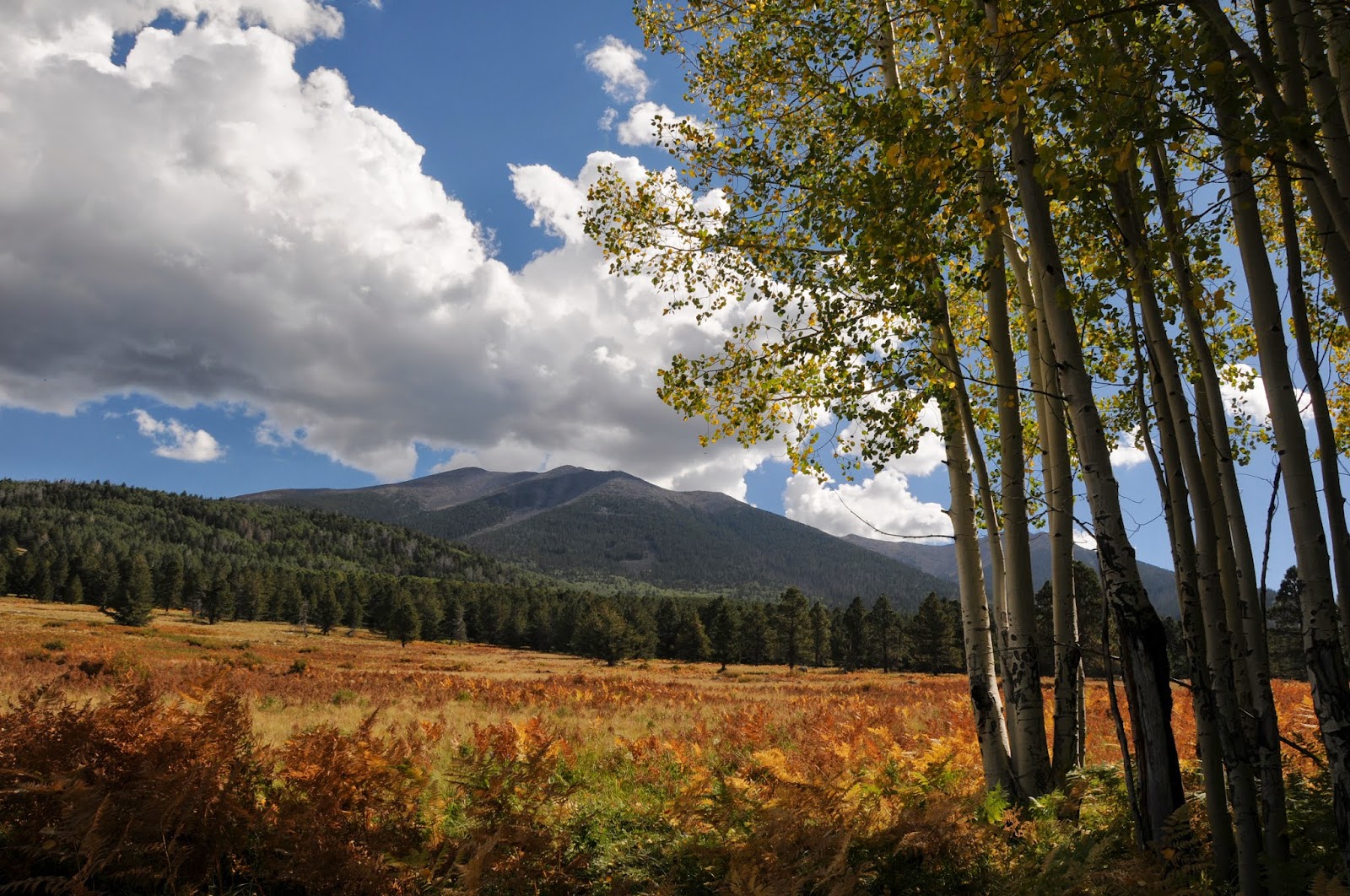
A substantial but steady ascent follows natural drainages through a wonderland of mica-flecked granite boulders flanking the path in sentry-like formation. 
Woodlands flush with broadleaf and coniferous trees shade the way framing continually changing vistas including glimpses of Prescott’s Granite Mountain.  Near the half-way point, a small clearing with picnic tables, restroom and a short spur trail to Spruce Mountain fire tower makes for a handy place to take a lunch break and do some exploring.  From here pick up the Isabella trail #377—to find it, stand with your back toward the restroom so that the fire tower is to your left. You’ll see a road directly ahead (this is NOT the trail), and two other roads off to the right.  Take the narrow middle road (go right) which is signed 377---if you do not see the sign, you’re on the wrong path.  Follow 377 back to the trailhead.
Oak trees cluster along Isabella Trail
LENGTH:  8.7-mile loop
ELEVATION: 6,400’ – 7,750’
RATING:  moderate
BEST SEASON: year round
DISTANCE FROM PHOENIX: 120 miles one-way
GETTING THERE:
From Phoenix, go north on I-17 to Cordes Junction.  Exit onto SR 69 west and proceed through the towns of Mayer, Dewey and Prescott Valley to the town of Prescott.  Continue on SR 69/Gurley Street through Prescott to Mt. Vernon Ave.  Turn south (left) onto Mt. Vernon Ave. (which will turn into Senator Highway) and continue 6.4 miles to the Groom Creek Trailhead on the left.  Roads are 100% paved.
INFO: Bradshaw Ranger District, Prescott National Forest, 928-771-4700