Mount
Union: Prescott
National Forest
 |
| View of Mt. Davis seen from 7979-foot Mt. Union |
 |
| Snow on the Dandrea Trail No. 285, 3-30-2019. |
 |
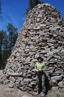
| The fire lookout on Mt. Union was built in 1933 |
 |
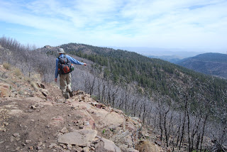
| Big views on the Yankee Doodle Trail No. 284 |
The bare bones trailhead straddles a drainage where the headwaters of the
Hassayampa River—spilling from the spring-laden slopes between Mount Davis
(named for President of the Confederate States, Jefferson Davis) and Mount
Union-- begin to gain momentum. Hop the
chugging stream and head toward the “285” sign, which marks the first leg of
the circuit. Trail No. 285 is an old mining road that was built long before the
concept of sustainability gained traction and thus has not held up well.
Thrashed by the forces of nature, the road has devolved into a quagmire of
loose rock and debris. Sometimes paralleling the Hassayampa drainage, sometimes
swamped by its overflow, trail conditions vacillate between poor and treacherous.
But, picking your way though is part of the adventure. Also, several unmarked
spur paths that spin off the main road can be confusing. To stay on track,
always head right at these junctions.
Between keeping an eye to the ground to avoid
falls, be sure to take time to appreciate the thick coniferous forest that surrounds
the trail. The canyon-bound lower mile of the route is wrapped in thick,
moss-draped woodlands dominated by Douglas and white firs plus spotty stands of
aspens struggling to find the sunlight they need to survive.
As the trail gains elevation, airy stands of Alligator
junipers and Gamble oaks take over, opening up views of distant Granite
Mountain.
 |
| The summit road was snow-covered on 3-30-2019. |
 |
| View from a high section of the Dandrea Trail |
 |
| A typical scene on the rocky Dandrea Trail |
 |
| Big Bug Mesa (mid field right) seen from Trail No. 284 |
 |
| Trail 285 climbs through the headwaters of the Hassayampa |
 |
| The saddle junction |
 |
| View from the summit of Mount Union |
 |
| Douglas fir trees dominate the canyon segment of the hike |
 |
| Mount Union is high point of the Bradshaw Mountains |
 |
| Trailhead at the edge of the Potato Patch community. |
LENGTH: 4
miles roundtrip
RATING:
difficult
ELEVATION:
6849 – 7979 feet
GETTING
THERE:
From State
Route 69 in Prescott, turn south on Walker Road (intersection with the
stoplight near the Costco center) and continue 10.5 miles to the “T”
intersection at Poacher’s Row that’s marked by sign for the Potato Patch
community. Turn left and continue 0.7 miles to where the road ends at the 285
trailhead. There’s parking for about two vehicles at the trailhead and there are additional
spaces along the road, but be respectful of the private property in the area and
do not block driveways.
High-clearance
vehicles are recommended as the last few miles of the access roads are on rough
dirt with potholes. There are no fees or facilities at the trailhead.
 |
| Summit marker. |
INFO:
Prescott National Forest


