

 MOUNT UNION
Prescott National Forest
MOUNT UNION
Prescott National Forest
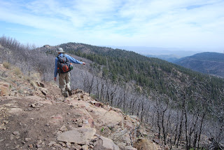
Priceless glimpses of Arizona’s beautiful central highlands await hikers on the summit of Mount Union--the 7,979-foot highpoint of the Bradshaw mountain range. Although this granite pinnacle is little more than the loftiest lump on a forested ridge above the Hassayampa River Basin, a hike to the peak still manages to deliver an enjoyable mountain experience complete with panoramic views, dizzying canyon drop-offs and a fire tower that has been in active service since 1933.
The uphill slog to “bag the summit” begins on the Dandrea Trail # 285. At just under the one-mile point, turn right onto the Yankee Doodle Trail # 284 and follow the cliff-hugging path to the peak through a landscape infused with weather-worn scrub and eroding volcanic rock.
HIGHLIGHTS: high point of the Bradshaw Mountain range
LENGTH: 4 miles roundtrip
RATING: moderate
ELEVATION: 6,849 -7,979 feet
DRIVING DISTANCE FROM PHOENIX: 130 miles
GETTING THERE:
From Phoenix, go north on I-17 to exit 262 for Highway 69. Go west (toward Prescott) on Highway 69 to Walker Road (County Road 57 which is just past the Costco center). Follow Walker Road south for 10. 5 miles to Poachers Row Road , turn left and follow the road to its end where there’s a sign for trail #285 across the creek. There’s limited parking along the road. Do not park in or block the private driveways in the area.
INFORMATION: (928) 443-8000,
http://fs.fed.us/r3/prescott/recreation/trails/bradsahw.shtml


 MOUNT UNION
Prescott National Forest
Priceless glimpses of Arizona’s beautiful central highlands await hikers on the summit of Mount Union--the 7,979-foot highpoint of the Bradshaw mountain range. Although this granite pinnacle is little more than the loftiest lump on a forested ridge above the Hassayampa River Basin, a hike to the peak still manages to deliver an enjoyable mountain experience complete with panoramic views, dizzying canyon drop-offs and a fire tower that has been in active service since 1933.
The uphill slog to “bag the summit” begins on the Dandrea Trail # 285. At just under the one-mile point, turn right onto the Yankee Doodle Trail # 284 and follow the cliff-hugging path to the peak through a landscape infused with weather-worn scrub and eroding volcanic rock.
HIGHLIGHTS: high point of the Bradshaw Mountain range
LENGTH: 4 miles roundtrip
RATING: moderate
ELEVATION: 6,849 -7,979 feet
DRIVING DISTANCE FROM PHOENIX: 130 miles
GETTING THERE:
From Phoenix, go north on I-17 to exit 262 for Highway 69. Go west (toward Prescott) on Highway 69 to Walker Road (County Road 57 which is just past the Costco center). Follow Walker Road south for 10. 5 miles to Poachers Row Road , turn left and follow the road to its end where there’s a sign for trail #285 across the creek. There’s limited parking along the road. Do not park in or block the private driveways in the area.
INFORMATION: (928) 443-8000, http://fs.fed.us/r3/prescott/recreation/trails/bradsahw.shtml
MOUNT UNION
Prescott National Forest
Priceless glimpses of Arizona’s beautiful central highlands await hikers on the summit of Mount Union--the 7,979-foot highpoint of the Bradshaw mountain range. Although this granite pinnacle is little more than the loftiest lump on a forested ridge above the Hassayampa River Basin, a hike to the peak still manages to deliver an enjoyable mountain experience complete with panoramic views, dizzying canyon drop-offs and a fire tower that has been in active service since 1933.
The uphill slog to “bag the summit” begins on the Dandrea Trail # 285. At just under the one-mile point, turn right onto the Yankee Doodle Trail # 284 and follow the cliff-hugging path to the peak through a landscape infused with weather-worn scrub and eroding volcanic rock.
HIGHLIGHTS: high point of the Bradshaw Mountain range
LENGTH: 4 miles roundtrip
RATING: moderate
ELEVATION: 6,849 -7,979 feet
DRIVING DISTANCE FROM PHOENIX: 130 miles
GETTING THERE:
From Phoenix, go north on I-17 to exit 262 for Highway 69. Go west (toward Prescott) on Highway 69 to Walker Road (County Road 57 which is just past the Costco center). Follow Walker Road south for 10. 5 miles to Poachers Row Road , turn left and follow the road to its end where there’s a sign for trail #285 across the creek. There’s limited parking along the road. Do not park in or block the private driveways in the area.
INFORMATION: (928) 443-8000, http://fs.fed.us/r3/prescott/recreation/trails/bradsahw.shtml
No comments:
Post a Comment