Find A Trail. Start Your Search Here:

Friday, September 26, 2008

NELSON TRAIL-PINE MOUNTAIN

NELSON TRAIL
Pine Mountain Wilderness 
Although the Nelson's don't live there anymore, remnants of their abandoned homestead still can be found in lichen-encrusted stone walls, some rusty metal "parts" of dubious origin and a bed of yellow hybrid tea roses.  An amazing variety of trees, including oak, juniper, maple, mahogany, sycamore and thin leaf alders shade the trail  as it winds through the ruins that lay crumbling along Sycamore Creek drainage.  The canopy harbors myriad wild birds and their disjointed harmonies collide and blend with notes of tea rose and pine on the wind. Along the way, listen for sounds of spring water percolating to the surface in the shallow pools that stand at the base of gigantic sycamores.  There's also a field where vines of wild gourds sprawl willy-nilly and sometimes cross the path.  At about the 2-mile point, the route intersects the signed Willow Springs junction.  From here, it's possible to follow connecting trails to the summit of Pine Mountain, however, due to fire damage and notoriously unreliable signage, it is necessary to do some serious of pre-hike map-plotting in order to stay on course.  Casual hikers should double back at the junction.
LENGTH: 4 miles round trip
RATING:  moderate
ELEVATION GAIN: 600 feet
GETTING THERE:
From Phoenix, go north on I-17 to the Dugas exit (FR 68, which is located 5 miles north of of the Cordes Junction interchange).  Turn left onto FR 68 and follow the tiny "68" signs east for 
19 miles to the Salt Flat campground, which is little more than a turn out in the road with a dilapidated outhouse.  FR 68 is a deeply-rutted dirt road with one shallow creek crossing.  A high-clearance vehicle is required; 4 x 4 if the road is wet.

Thursday, September 25, 2008

ABINEAU-BEAR JAW LOOP

ABINEAU-BEAR JAW Kachina Peaks Wilderness Known for its carousel of changing views and ecosystems, the Abineau-Bear Jaw loop is among the most popular hikes in the Flagstaff area. The trail’s multiple personality can be experienced several ways, although most hikers prefer to tackle the tougher part first by beginning on the Abineau trail. From the signed trailhead (8,500 feet of elevation), the path heads up Abineau Canyon and climbs steeply on rugged terrain through dense conifer forests. Rocky Mountain irises, penstemon and daisies wash the slopes in vivid hues of violet, orange and yellow and soften the devastating effects of a February 2005 avalanche that scoured a large portion of the upper trail. At the two-mile point (10,400 feet), the trail meets the talus slopes below Humphreys Peak and the junction with an old dirt road. From there, views of the volcanic fields of northern Arizona are breathtaking. To connect with the Bear Jaw trail, follow the dirt road (also shown as the Waterline or Pipeline road on some maps) downhill for 2 miles and look for the easy-to-miss sign on the left. Along the Bear Jaw trail, the forest changes from conifer to mostly aspens and alpine meadows. The trail is a bit treacherous in spots, so, proceed with care and enjoy the fact that it’s all down hill back to the trailhead. LENGTH: 6.7 mile loop RATING: difficult ELEVATION: 8,500- 10,400 feet GETTING THERE:
EAST ACCESS:  From Phoenix, take I-17 north to Flagstaff. Once in Flagstaff, drive north on Highway 89 for 12 miles to FR 420, which is across from the turnoff for Sunset Crater. Continue on FR 420 for about a half-mile and then turn right onto FR 552. Follow FR 552 to FR 418 and turn right. Continue on FR 418 for about 7 miles to FR 9123J. Turn left onto FR 9123J and drive another 1.2 miles to the trailhead. The dirt roads are accessible by sedan, but a high-clearance vehicle is recommended.
WEST ACCESS:
From Flagstaff, go 19.5 miles north on US 180 to milepost 235.2, turn right onto Hart Prairie Road (north access of FR 151), go 1.6 miles to FR 418, turn left and continue to the signed turn off for Bear Jaw (FR9123J) on the right near the 3-mile marker and follow the signs 0.6 mile to the trailhead. FR 151, 418 and 9123J are maintained dirt, suitable for sedan, but high clearance is recommended.
INFO: Flagstaff Ranger District, Coconino National Forest, 928-526-0866, http://www.fs.fed.us/r3/coconino/recreation/peaks/abineau-bear-jaw-tr.shtml

Tuesday, September 23, 2008

DEVIL'S BRIDGE

DEVIL’S BRIDGE Red Rock Secret Mountain Wilderness Whatever you do, don’t let the fact that you’ll have to bump elbows with camera-toting tourists and jockey for a parking spot at the trailhead deter you from visiting the natural sandstone arch known as Devils Bridge. Untold bazillions of visitors can’t be wrong, and it’s easy to see why this trail is one of Sedona’s most popular hiking destinations. Despite the crowds, a sense of wilderness prevails. Majestic pine trees, desert scrub and colorful wildflowers decorate the sandy, red-earth path and accentuate dramatic views. Beneath the soaring bridge, brisk canyon breezes and mottled rays of sunlight funnel through the sandstone and play on the stratified walls of the high-desert canyon. Near the end of the easy-to-follow trail, an obvious spur path leads to the top of the arch where sights touch the soul and the roar of the wind hushes the din of the crowds. LENGTH: 2 miles round-trip RATING: moderate ELEVATION: 4607' - 4800'   FEE: A Red Rock Pass ($5 daily fee per vehicle) is required. Available at many retail outlets in Oak Creek and Sedona. GETTING THERE: From the junction of Highway 179 and Highway 89A in Sedona, turn left onto Highway 89A and continue for 3.2 miles to Dry Creek Road. Turn right onto Dry Creek Road (Forest Road 152C) and continue for 2 miles to the turn off for Forest Road 152 on the right. Continue on FR-152 (maintained dirt) for about a mile to the signed parking area for Devil’s Bridge.

WILSON MOUNTAIN

WILSON MOUNTAIN NORTH TRAIL #123 Red Rock Secret Mountain Wilderness, Sedona NOTE: THE PHOTOS IN THIS POST SHOW THE MOUNTAIN JUST MONTHS BEFORE THE June 2006 BRINS FIRE TOOK OUT MOST OF THE VEGETATION . SINCE THEN , THE TRAIL HAS BEEN RESTORED AND DESPITE THE LOSS OF TREES, IT'S STILL A GREAT HIKING DESTINATION. Other trails damaged by this fire include: Sterling Pass and Brins Mesa. A pleasant alternative to the more popular Wilson Mountain South trail that starts in the lot just past Midgley Bridge, the alternate north route has many advantages. First, it’s shady for most of the way. It’s slightly longer than the south route, but it’s got 100 feet less elevation gain ( a big advantage at high altitude). Encinoso waterfall sometimes flows after heavy rain and during snow melt (visible at about the .25 mile point on the first ridge.). Most of the strenuous climbing is crammed into a half-mile canyon-bound segment it’s pretty steep and in some places the trail is just inches from the precipice. The canyon winds are a constant companion, whipping up from a thousand feet below and accelerated by the narrow canyon walls. At about the 3-mile point, the trail levels out onto a wide bench with remarkable views of Oak Creek Canyon and intersects the Wilson South trail. From there, the trail is now known as the Wilson Mtn trail, and with most of the hard climbing behind, the final mile climbs 800 feet to the top. The summit is huge and there are two paths that lead to lookout points: one overlooks Sedona , the other overlooks the Oak Creek Canyon. LENGTH: 6.8 miles round trip (including side trips to the view points) ELEVATION GAIN: 4,600- 7, 000 feet RATING: difficult GETTING THERE: From Phoenix, go north on I-17 to the Sedona exit Highway 179. Turn east onto Highway 179 and continue into the town of Sedona. At the junction of Highway 179 and Highway 89A (the “Y” intersection) turn right onto Highway 89A and continue for 5.3 miles to the Encinoso picnic area on the left. Access roads are paved all the way and there are restrooms at the trailhead. The hike starts at the signed kiosk at the north end of the picnic area.

PIPELINE CANYON

PIPELINE CANYON TRAIL Lake Pleasant Regional Park In the desolate desert canyons surrounding Lake Pleasant, the descendents of hardy African beasts roam in happy herds. It’s impossible to know for sure if the area’s wild burros were abandoned or if they escaped from the mining camps that employed them back in the 1800s. Generations removed from their ore-hauling ancestors, the sturdy burros are easy to spot near the coves and inlets along the Pipeline Trail. A cinch to follow, this easy trail begins with a mild descent along a ridge above a quiet estuary. At the bottom of the canyon, cross the floatation bridge and continue hiking among the gigantic saguaros and pungent creosote bushes that populate the rambling hillsides above the lake. LENGTH: 3.6 miles round-trip RATING: easy ELEVATION GAIN: 100 feet GETTING THERE: From Phoenix, go north on I-17 to Carefree Highway. Go west (left) on Carefree Highway and continue for 15 miles to Castle Hot Spring Road. Turn north (right) onto Castle Hot Spring Road and continue to the main entrance for Lake Pleasant Regional Park. From there, continue on North Park Road to the south trailhead located near a large water tank just past the turn off for Peninsula Blvd. The unsigned trail begins near the map box to the north of the restrooms. Fee: There’s a $5 daily fee per vehicle.

BENHAM TRAIL

BENHAM TRAIL Kaibab National Forest Thick stands of spruce and fir trees spike the thin air on the Benham Trail with a jolt of invigorating mountain aroma. Bursting out of the highlands west of Flagstaff, 9,256-foot-tall Bill Williams Mountain is the dominant landmark in the area and the Benham Trail is the most gradual and scenic path to its summit. Bill Williams Mountain is a lava dome volcano that erupted from the earth’s core more than 4 million years ago and it’s among the oldest of the volcanic features of northern Arizona. The molten rock that pushed up the mountain in a series of oozing flows has since been camouflaged in a layer of oaks, aspens, wildflowers and fragrant conifer forests. The trail crosses FR 111 (the dirt road that leads to the summit) three times before it finally merges with it for the final half-mile hike to the top. Because the peak is cluttered with a fire lookout and an array of communication towers, you’ll need to explore carefully to discover the many panoramic viewpoints where swarms of ladybugs and inquisitive rock squirrels live quietly in the metal jungle. LENGTH: 9 miles round trip RATING: Moderate ELEVATION: 7,050-9,256 feet GETTING THERE: From Phoenix, take I-17 north to Flagstaff. From Flagstaff, connect to I-40 west and drive for 33 miles to the town of Williams. In Williams, go south on Fourth Street (FR 73/Perkinsville Road) and continue for about 3.5 miles to FR 140. Go right onto FR 140 and follow the signs for one quarter of a mile to the signed trailhead where there are restrooms but no other facilities. The paved and gravel roads are passable by sedan.
INFO & MAP: http://www.fs.usda.gov/Internet/FSE_DOCUMENTS/stelprdb5189838.pdf

EAST WEBBER CREEK

EAST WEBBER TRAIL #289 Tonto National Forest 
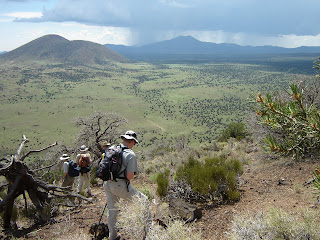
Woodsy and cool, little-used East Webber trail cuts a thin path through a shady pine forest that culminates at an array of springs where icy water gushes from a canyon wall at the base of the Mogollon Rim. The first three miles of the hike follow pine-shaded, connecting trails that skirt the perimeter of Boy Scout Camp Geronimo. Once past the camp, the trail transitions from a pleasant walk in the forest to a fascinating streamside exploration. Hugging the banks of Webber Creek for its entire length, the East Webber trail presents a variety of fun, water-themed adventures. At least a dozen creek crossings define the hike. Some involve walking across fallen logs while others require stone-hopping or ankle-deep wading. As the trail plows deeper into the forests beneath the Rim, temperatures drop and the canopy funnels sunlight into narrow beams that play upon the crystal clear waters and abundant riparian vegetation. Columbine, wild raspberry and yellow monkey flowers bob along the water’s edge adding splashes of color to the shimmering, golden-brown gravel of the streambed. Near the end of the trail, the path gets very steep and difficult to follow. However, it’s well worth the effort to follow the sound of rushing water (and the orange trail tape placed by the scouts) up the canyon to visit the springs where silken sheets of fresh, white water spill over tufts of vibrant green grasses into the creek below. LENGTH: 9.8 miles out-and-back to the springs RATING: moderate (difficult in the last mile) ELEVATION GAIN: 1,060 feet GETTING THERE: From Phoenix, go north on Highway 87 for about 90 miles to the town of Payson. From Payson, continue north on Highway 87 for about 12 miles to “Control Road” (Forest Road 64) near milepost 265 on the right (a couple miles past Tonto Natural Bridge State Park). Turn right onto FR-64 and continue for 6 miles to Webber Creek Road (Forest Road 440). Turn left (north) onto FR-440 and go 2 more miles to the signed Geronimo trailhead on the left. No facilities. HIKE DIRECTIONS: This hike involves connecting three trails and because the route requires mucking through a quagmire of old roads, spur paths, confusing junctions and crappy signage; this hike is not a good choice for the directionally-challenged. Here’s the plan: From the trailhead, HIKE ACROSS FR-440 and connect to Highline Trail #31 (west side of the road across from the main Geromino trailhead sign). Cross the creek and follow Highline #31 for several yards to a junction sign—veer right and continue uphill roughly 0.15 mile to a 3-way junction. There are no signs here. Directly ahead, the road dips downhill heading towards a gate---this leads to the scout camp, do not take this road. Instead, veer left where you have 2 choices. The footpath heading uphill is the continuation of #31 and is marked by white diamonds—this path will intersect the Geronimo Trail in about 0.1 mile. The wider road to the far left is the Geromino Trail #240 proper. Either option works. Once on Geronimo, follow this wide old road (stay on the main road, ignore the many cross roads) to another 3-way junction. This one has two signs, one for East Webber and another for West Webber, Turkey Spring and FR 218. (UPDATE: on 8-26-12 a hiker reported to me that that this 3-way sign is missing. If you can can confirm, please leave a comment.) Head right here and begin climbing following the blue diamonds until you reach a fancy wooden “Webber” sign. From here, follow the yellow markers for East Webber #289. The path is usually clear enough to easily hike 1.5 miles. After that though, be prepared to work through downed trees and overgrown brush to get to the springs. NOTE: some outdated books and online sources wrongly state that the East Webber Trail may be accessed by hiking through Boy Scout Camp Geronimo. The camp is private property, do not trespass.
MORE PHOTOS:
http://www.facebook.com/media/set/?set=a.3069354351581.99739.1795269672&type=1&l=3abd3b8819

COLTON CRATER

COLTON CRATER San Francisco Volcanic Field There are no formal trails to the rim of Colton Crater and the hike is simply a short climb up the cinder slope to the rim. Nearly 3-miles in circumference, the rim of Colton Crater undulates gently, providing views that stretch all the way to the Grand Canyon and southern Utah. Silent for millennium, and worn by the elements into rounded, juniper-encrusted mounds, Colton Crater harbors a very special surprise for adventurous hikers. Deep within the eroding crescent of Colton’s volcanic walls is another tiny, red cinder cone and although the miniature volcano bears a striking resemblance to its world-famous and frequently visited cousin, Sunset Crater, Colton’s miniature scion exists in blissful anonymity. LENGTH: 1.5 miles to 3 miles round trip (optional) RATING: moderate ELEVATION: base: 7120', summit: 7330', crater floor: 6240' GETTING THERE: From Phoenix, travel north on I-17 to Flagstaff. Just before entering Flagstaff, connect to I-40 east and continue to exit 201. Take exit 201 and go north on Highway 89 and continue for 27 miles to just south of milepost 446 (south of Hank’s Trading Post) where there’s an unmarked dirt road on the left. Get on the dirt road, set your odometer to zero and continue west. At the half-mile point, stay left at the fork and then continue heading toward the obvious symmetrical profile of SP Mountain for about six miles to where there’s a rusty black water tank with a pointed roof on the left. Turn left just past the water tank and follow the old 4x4 road toward the mound of Colton Crater. Watch for a faint road that makes a sharp right-turn heading toward the crater’s lowest point. Park anywhere along the fence that parallels the road, then simply head uphill. SEE THE SP CRATER POST FOR MORE DRIVING & DIRECTION TIPS.

Monday, September 22, 2008

MESCAL RIDGE

MESCAL RIDGE TRAIL #186 Hellsgate Wilderness Area Follow the guide given for the Bear Flat hike (separate blog entry) to the Bear Flat-Mescal Ridge junction, then go right (west) at the trail sign and continue up a rocky path onto Mescal Ridge. Views of the Mogollon Rim and other curiosities abound along the scenic ridge. Lichen-covered boulders of quartzite litter the perimeters of the trail and provide comfortable niches for horned lizards. Lush valleys of pine, scrub oak, agave, yucca and manzanita plunge hundreds of feet downhill on both sides of the trail. Cattle still graze in the area and there’s an old corral, feeding trough and watering hole along the way. At about the 2.5-mile point, there’s a large clearing with sweeping views and although it makes a nice place to stop, it’s not the end of the trail. From there, continue along the faint footpaths for about another mile to the point where the trail skirts the very edge of Mescal Ridge. There, spectacular drop-offs and big sky views give a true sense of “wilderness” before the trail dead-ends into a private property fence. LENGTH: 6 miles round trip RATING: Moderate ELEVATION GAIN: 4960' - 5610'    GETTING THERE: From Phoenix, drive east on Loop 202 and connect to Highway 87 north (Country Club Drive). Continue north on Highway 87 for about 90 miles to the town of Payson. Once in Payson, go right (east) onto Highway 260 and continue for 11.4 miles to the turn off for FR 405A, which is just past milepost 263 on the right. NOTE: this turn off is not signed, so start paying attention once you pass the Little Green Valley area because the turn off is just past it. Continue on FR 405A, for another 2.7 miles to the signed junction for Bear Flat and FR 405. Follow FR 405 (veer right) for just over 3 more miles to the Bear Flat campground. FR 405 is a good dirt road but is narrow and has several abrupt hairpin turns and steep drop offs. There are ample pullout areas for passing but it is advisable to drive slowly and with caution.

BEAR FLAT

BEAR FLAT TRAIL #178 Hellsgate Wilderness Area, Payson The hike begins with an immediate crossing of Tonto Creek. From the trailhead sign, scope out the wooden trail marker across the creek and then head toward it using the handy stepping stones to hop the shallow creek. Once at the trail sign, head east (left) toward the houses that are on private property and follow the carined trail up through a conifer forest to the wilderness area signs. From there, the easy-to-follow trail heads steeply uphill through pines and junipers for one mile to the Bear Flat-Mescal Ridge junction sign. From there, go left (east) and continue for another mile through open grassy meadows and manzanita where views of the Rim country stretch out for miles. After a short distance, the trail turns abruptly downhill into a densely forested canyon to the wilderness area boundary and the turn around point for this hike. LENGTH: 5 miles round trip as described here.  Full trail is 9.25 miles one-way RATING: easy - difficult ELEVATION: 4960'-5610' (2500' - 5800' for entire trail) GETTING THERE: From Phoenix, drive east on Loop 202 and connect to Highway 87 north (Country Club Drive). Continue north on Highway 87 for about 90 miles to the town of Payson. Once in Payson, go right (east) onto Highway 260 and continue for 11.4 miles to the turn off for FR 405A, which is just past milepost 263 on the right. NOTE: this turn off is not signed, so start paying attention once you pass the Little Green Valley area because the turn off is just past it. Continue on FR 405A, for another 2.7 miles to the signed junction for Bear Flat and FR 405. Follow FR 405 (veer right) for just over 3 more miles to the Bear Flat campground. FR 405 is a good dirt road but is narrow and has several abrupt hairpin turns and steep drop offs. There are ample pullout areas for passing but it is advisable to drive slowly and with caution.
INFO: Payson Ranger District, Tonto National Forest
http://www.fs.usda.gov/recarea/tonto/recreation/hiking/recarea/?recid=35633&actid=50

HUMPHREYS PEAK

HUMPHREYS PEAK Coconino National Forest Wearing fleece jackets and warm gloves in the middle of summer might sound odd, but it’s de rigueur for hiking Arizona’s highest trail. Considered by many to be one of the best and most challenging hikes in the state, the trail is usually quite crowded. The Humphreys Peak trail ascends the rocky slopes of Arizona’s only strato volcano that towers over the town of Flagstaff and the surrounding Coconino Plateau. As the trail gains elevation, plant life declines until only weather-tortured bristlecone pines cling tenaciously to the harsh talus, and above tree line, (11,400 feet) even the sturdy pines die out. On the blustery and barren 12,633-foot summit, there’s a windbreak shelter made of lava rocks that makes a good place to escape the chill, pull on your gloves and enjoy the experience of Arizona’s only tundra environment. An overnight stay in Flagstaff to acclimate to the altitude is recommended for Valley dwellers. LENGTH: 9 miles round trip RATING: difficult ELEVATION: 9,283-12,633 feet GETTING THERE: From Phoenix, go north on Interstate 17 to Flagstaff. Once in Flagstaff, drive north on U.S. 180 for 7 miles to Forest Road 516 (Snowbowl Road) and continue for 7.4 miles to the lower parking lot. The trailhead is at the north end of the lot. The paved roads are accessible by sedan.
INFO:
https://www.fs.usda.gov/recarea/coconino/recreation/ohv/recarea/?recid=55108&actid=50