

 COLTON CRATER San Francisco Volcanic Field
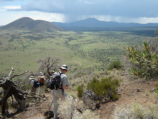
 There are no formal trails to the rim of Colton Crater and the hike is simply a short climb up the cinder slope to the rim. Nearly 3-miles in circumference, the rim of Colton Crater undulates gently, providing views that stretch all the way to the Grand Canyon and southern Utah. Silent for millennium, and worn by the elements into rounded, juniper-encrusted mounds, Colton Crater harbors a very special surprise for adventurous hikers. Deep within the eroding crescent of Colton’s volcanic walls is another tiny, red cinder cone and although the miniature volcano bears a striking resemblance to its world-famous and frequently visited cousin, Sunset Crater, Colton’s miniature scion exists in blissful anonymity.
LENGTH: 1.5 miles to 3 miles round trip (optional)
RATING: moderate
ELEVATION: base: 7120', summit: 7330', crater floor: 6240'
GETTING THERE: From Phoenix, travel north on I-17 to Flagstaff. Just before entering Flagstaff, connect to I-40 east and continue to exit 201. Take exit 201 and go north on Highway 89 and continue for 27 miles to just south of milepost 446 (south of Hank’s Trading Post) where there’s an unmarked dirt road on the left. Get on the dirt road, set your odometer to zero and continue west. At the half-mile point, stay left at the fork and then continue heading toward the obvious symmetrical profile of SP Mountain for about six miles to where there’s a rusty black water tank with a pointed roof on the left. Turn left just past the water tank and follow the old 4x4 road toward the mound of Colton Crater. Watch for a faint road that makes a sharp right-turn heading toward the crater’s lowest point. Park anywhere along the fence that parallels the road, then simply head uphill.
SEE THE SP CRATER POST FOR MORE DRIVING & DIRECTION TIPS.


 COLTON CRATER San Francisco Volcanic Field There are no formal trails to the rim of Colton Crater and the hike is simply a short climb up the cinder slope to the rim. Nearly 3-miles in circumference, the rim of Colton Crater undulates gently, providing views that stretch all the way to the Grand Canyon and southern Utah. Silent for millennium, and worn by the elements into rounded, juniper-encrusted mounds, Colton Crater harbors a very special surprise for adventurous hikers. Deep within the eroding crescent of Colton’s volcanic walls is another tiny, red cinder cone and although the miniature volcano bears a striking resemblance to its world-famous and frequently visited cousin, Sunset Crater, Colton’s miniature scion exists in blissful anonymity. LENGTH: 1.5 miles to 3 miles round trip (optional) RATING: moderate ELEVATION: base: 7120', summit: 7330', crater floor: 6240' GETTING THERE: From Phoenix, travel north on I-17 to Flagstaff. Just before entering Flagstaff, connect to I-40 east and continue to exit 201. Take exit 201 and go north on Highway 89 and continue for 27 miles to just south of milepost 446 (south of Hank’s Trading Post) where there’s an unmarked dirt road on the left. Get on the dirt road, set your odometer to zero and continue west. At the half-mile point, stay left at the fork and then continue heading toward the obvious symmetrical profile of SP Mountain for about six miles to where there’s a rusty black water tank with a pointed roof on the left. Turn left just past the water tank and follow the old 4x4 road toward the mound of Colton Crater. Watch for a faint road that makes a sharp right-turn heading toward the crater’s lowest point. Park anywhere along the fence that parallels the road, then simply head uphill. SEE THE SP CRATER POST FOR MORE DRIVING & DIRECTION TIPS.
No comments:
Post a Comment