Find A Trail. Start Your Search Here:

Showing posts with label fire tower. Show all posts

Monday, August 19, 2019

GREENS PEAK: Hike to the High Point of the Springerville Volcanic Field

GREENS PEAK
The beastly profile of Greens Peak near Greer.
From a distance, the lopsided hump of Greens Peak with its sparsely vegetated south face and top fringe of conifers resembles the shaggy profile of an African wildebeest.
Escudilla Mountain (horizon on right) seen from Greens Pk.
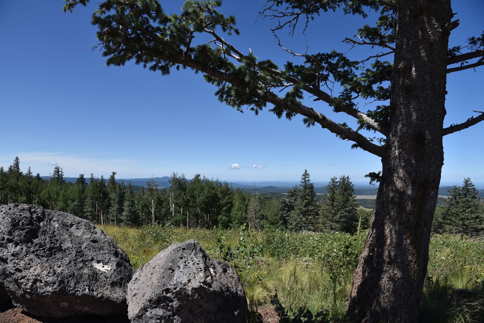
The funny-looking hill sits a few miles north of State Route 260 near the town of Greer, between the lofty peaks of eastern Arizona’s White Mountains and the colorful badlands of the Petrified Forest National Park and offers a unique vantage point in the ecoregion between alpine forests and high-desert plains.
Looking toward Springerville from Greens Peak
Mima mounds dot the meadows around Greens Peak
The hike climbs to the top of a cinder cone volcano
Fleabane grow in dense clumps along the route
Aspens thrive on the north face of Greens Peak
The 10,134-foot extinct cinder cone volcano is the highest point of the Springerville Volcanic Field-- a swath of hundreds of diverse geological wonders that runs roughly between the towns of McNary and Alpine. Surrounded by miles of open rangeland, meandering creeks and sweet-smelling fir-spruce woodlands, the area is also home to dozens of easy-to-explore volcanic elements and glacial imprints. For an in-depth but approachable read about this fascinating corner of Arizona, check out A Guide to the Geology of the White Mountains and the Springerville Volcanic Field, Arizona by John V. Bezy and Arthur S. Trevena. It’s available as a free download on the Arizona Geological Survey website. 
Hundreds of geological features are visible from Greens Pk
The book describes several field trips to some of the area’s most interesting peculiarities. The keynote trip is a hike up to Greens Peak.  
Summit of Greens Peak has great views in all directions
With its beastly appearance and half bald, half forested slopes, the mountain is a natural draw for curious visitors in search of an off-the-radar summit hike with primo views. Although it’s short in length and ascends on a gradual, undulating grade, the trek is not for the faint-of-heart. It begins at over 9,000 feet in elevation where thin air will tax the lungs of unacclimated Valley dwellers. If you’re not up to the 600-foot haul to the summit, there are plenty of curiosities to explore around the mountain’s base including the mima (pronounced may-muh) mounds.
Sunrise ski area and Fence Tank seen from Greens Peak
One of the enduring mysteries of White Mountain geology, is the origin of the mounds.
Harebells bloom in alpine meadows through September
Rodents, imbedded root systems and creatures from outer space all have been credited with making these roundish, lumps of gravel that average 2 feet high in the breezy meadows below the peak.
Summit marker on 10,134-foot Greens Peak
The prevailing theory is that these odd lumps are remnants of a glacial ice field that receded some 25,000 years ago leaving behind a landscape that smacks more of Iceland than Arizona.   
A pollinator alights on a Western yarrow plant.
Don’t be intimidated by the hill’s steep, stark appearance. Following an edge-hugging road that makes a 180-degree swing along the mountain’s west and south flanks, the steady uphill slog is easier than it looks.  Along the lung-pumping climb, vista points appear around every kink in the road.
North view from the summit of Greens Peak
Look for surrounding hike hubs like Pole Knoll, Mount Baldy (11,420 feet) and the trails around Big Lake. Near the top, the distinctive profile of Escudilla Mountain (10,912 feet) that sits near the New Mexico border shows a frenzy of aspen resurgence in the scar of the 2011Wallow Fire.  On the summit, a fire lookout and communication towers rise above the coniferous woodlands that cover the mountain’s northeast flanks.
Greens Peak seen from nearby Fence Tank corral.
To the south, the web-like patterns of ski runs at Sunrise Park Resort near Greer stand out above a landscape of misshapen volcanic bluffs, mounds and eroded cones.
Cattle graze in meadows at the base of the mountain.
The mountain’s breezy high-elevation edges are also ideal for birdwatching or spotting herds of pronghorn, elk and ubiquitous cattle roaming among lumpy grasslands and watering holes below.
A fire lookout and communication towers on the summit
LENGTH: 2 or 4 miles roundtrip
RATING: moderate
ELEVATION: 9,520 – 10,134 feet
GETTING THERE:
From Pinetop-Lakeside, travel east on State Route 260 (toward McNary).  Continue to roughly 3 miles past State Route 273 to Forest Road 117 near milepost 380 on the left (about a mile past the Railroad Grade trailhead).  Follow FR117 north for 3 miles to a "Y" junction at Forest Road 61 where a sign reads “Greens Peak 2 miles”. You can park here for a 4-mile roundtrip hike or veer left and drive another mile to the next “Y” intersection at FR61/61C
for a 2-mile hike.  Roads are maintained dirt and cinder and passable by sedan.
INFO: Arizona Geological Survey
Arizona Wildlife Trails:

Monday, May 20, 2019

BAKER BUTTE

BAKER BUTTE
Lilacs frame Baker Butte fire tower on the Mogollon Rim
A hike up to Baker Butte culminates at an idyllic, pine-shaded pinnacle. Swarms of hummingbirds whip through lilac-scented air and masses of ladybugs cling to trees, shrubs and knee-high wildflowers.
Fire lookout Shirley Payne and her horse Rameses.
Nearby, a horse chomps hay in a makeshift corral while a friendly black Labrador retriever noses a tennis ball. Perched on a knoll at the edge of the Mogollon Rim, the mood surrounding the Baker Butte fire tower is as calm and pastoral as a romantic passage in a Victorian novel.

Pine thermopsis (golden pea) bloom April - July
But this enviable life removed from city heat, traffic and noise belies a very serious purpose.
“Are you coming up?” The voice of fire lookout Shirley Payne broke the silence as she called down to me and my hiking partner from the catwalk of the 30-foot-high tower. “Oh, yeah,” was my no-brainer answer.  Payne, who has worked in the tower for 23 years, welcomed us with a plate of fresh-baked poppy seed muffins.
Payne's dog Jeffrey takes a break near the corral.
The tower is located near the western edge of Rim Road (Forest Road 300)--a 51-mile dirt route that runs between State Route 87 south of Clints Well to State Route 260 near Forest Lakes. Rim Road makes for an iconic scenic drive for anybody with a high-clearance vehicle and the fortitude to endure some queasy, edge-hugging sections. Of the many Coconino National Forest fire lookout towers that dot the Rim, Baker Butte is one of the easiest to reach on foot. For a moderate 3-miler, park at Baker Lake (usually not more than a soggy bog) at the junction of FR 300 and SR 87 and hike 1.2 miles on FR 300 to Forest Road 300B (the road to the lookout) where there’s a parking area for the General Crook Trail, then continue 0.4-mile uphill to the summit. The summit road passes through archways of Gambel oak trees, pines and Douglas firs. Fringed with ferns, raspberry brambles and colorful spreads of Canada violets, Pine thermopsis, sandwort and wild strawberries, the road twists uphill in long loops landing at the base of the fire tower.
Views from tower catwalk stretch from Flagstaff to Tucson
The tower, which earned a spot on the National Historic Lookout Register in 2006, wears its heritage well. Constructed with a not-so-subtle blend of original, repurposed and new building materials, the practical yet homey loft is softened by Payne’s collection of quilts, plants and mementos.  Neatly arranged instruments, radios, binoculars and maps speak to the intense, sometimes harrowing, work of fire spotting and coordination of incident response teams—the daily grind of a fire lookout.
Thick tree cover on the summit road hike.
The long-gone original tower cabin that was built in 1921 was replaced in 1937 with the present 12’ x 12’ model that’s perched on a metal skeleton with wooden stairs. The catwalk was added in 2009 and various upgrades to walls and windows surround a floor covered in speckled, cracked linoleum that smacks of mid-century utilitarianism.
Copies of Payne’s book, Baker Butte Journal 2010, sit near the guest register. Well worth its $20 sale price, the photo-rich volume presents a slice-of-life account of a season in the tower. It's packed with play-by-play descriptions of wildfire response, turbulent mountain weather, recipes and the misadventures of “cidiots” (visitors from cities with irresponsible forest habits) who litter, cause damage, raise hell and sometimes need rescuing.  A stroll around the catwalk reveals see-forever vistas. On most days, the peaks of Flagstaff, Williams and the White Mountains can be seen with the naked eye standing over seas of Ponderosa pines. On the best days, Picacho Peak and Mount Lemmon in Tucson show their silhouettes 200 miles to the south. 
Jeffrey is always ready for a game of fetch
Payne offers fresh-baked muffins to tower visitors.
Below the tower, a tiny cabin serves as Payne’s home for six months (usually May – October) each year. Draped in lilac bushes that were planted in the 1980s, the ad hoc abode has been expanded, adapted and upgraded over decades of use.
Hummingbirds gather at feeders placed around the tower
Tools of a fire lookout's trade.
The sunny kitchen was salvaged from a Depression Era Civilian Conservation Corps camp at Mormon Lake and repurposed into a compact, fully-equipped work space (with hot and cold running water to boot) where Payne cooks up her culinary specialties like the yummy muffins she serves visitors.  Some of her recipes use wildflowers and berries harvested from the forest.
Payne's book describes her experiences working in the tower
Outside, an array of hummingbird feeders attract several species including the Broad-tailed, Rufous and Magnificent. During summer, flocks of the glinting little birds can drain a feeder in just hours, which keeps Payne busy with refill runs up to three times a day. In addition to the elk, chipmunks, turkeys, western tanagers and deer that hang out around the tower, Payne keeps two special four-legged helpers at her mountain top work environment. Rameses, a 21-year-old Missouri Fox Trotter--a gaited breed (horses with a sure-footed, rhythmic stride) who loves mint candy treats, and Jeffrey, a friendly  3-year-old black lab with a fetch fetish and boundless energy provide companionship and assistance. 
Raspberry brambles produce fruit in late summer
During fire season, the Baker Butte tower is open to the public between 8:00 a.m. and 4:30 p.m. when Payne is on duty and closed for lunch between noon and 1 p.m.
The cabin kitchen was salvaged from a CCC camp
Canada violets bloom April - September
As Arizona heads into another fire season, forest visitors should respect fire restrictions and safety protocols. The last thing any fire lookout wants to see is a plume of smoke drifting skyward from a human-caused blaze.  When visiting a fire tower, please observe proper etiquette.

• Respect visiting hours. Do not attempt to enter a tower when no lookout is present.
• Wait to be invited. Lookouts may not allow visitors when monitoring an active fire incident.
FR 300B begins across from a General Crook trailhead
• Lighten up. Leave bulky packs and trekking poles behind. Tower stairs are narrow and space is tight inside.
• Ask permission before taking photos or approaching companion animals.
• Listen up. Follow the lookout’s instructions and don’t touch instruments. 
• Learn something. Ask questions. Most lookouts are veritable founts of knowledge about the forests they watch over.
Begin at Baker Lake (bog) for a 3-mile hike to the tower.

LENGTH:  3 miles roundtrip from Baker Lake or 0.8 mile roundtrip from the General Crook trailhead.
RATING: moderate
ELEVATION:  7430 - 8074 feet from Baker Lake or 7866 – 8074 from General Crook trailhead.
GETTING THERE:
From the State Route 87/260 junction in Payson, go 28 miles north on SR 87 to Forest Road 300 (Rim Road) located just past milepost 281.
Option 1: Park in the dirt turnouts on Rim Road near Baker Lake just a few yards in from SR 87.
Option 2: Follow FR 300 (make a sharp left at a Y junction at  0.1-mile)  1.2 miles to the Baker Butte Summit Road (FR 300B). There’s parking directly across from the summit road in the General Crook trailhead. Forest Road 300 is bumpy dirt but passable by passenger cars.
INFO:
Fire Management Coconino National Forest
-->

Monday, July 9, 2018

VISHNU TRAIL

VISHNU TRAIL: A Tiny Trek on the Edge of the Grand Canyon.
A hiker on the Vishnu Trail approaches G.C. views.
Whether hiked as an inspirational appetizer, warm up walk or add-on trek while exploring around the South Rim of the Grand Canyon near the town of Tusayan, the Vishnu Trail is a quick and easy diversion with tantalizing views and opportunities to engage with the Arizona Trail.  
Vishnu Trail connects with the Arizona Trail
The hike begins directly under the Grandview Lookout Tower, where the well-marked path heads north through wildlife-rich pine-oak woodlands and shrubby enclaves.  After roughly a quarter-mile, glimpses of the hazy, russet chasm begin to appear through the trees.
Grandview Lookout under stormy skies. Yes, we got soaked!
An oak-shaded passage on the Vishnu Trail.
As the trail progresses to its overlook spur, scenic vistas unwrap like unexpected gifts that surprise and thrill. 
Vishnu Temple (right) seen from the trail overlook.
A metal gate marks the threshold to the best sights of the hike. Beyond the gate, canyon vistas take center stage, culminating at a boulder ledge above a sea of pinion and ponderosa pines that creeps up to the colorfully-layered walls of the canyon.  Views of dramatic rock formations, fog-veiled depths and the distant highlands of the Kaibab Plateau tease the imagination and seed ambitions for more canyon hiking.   Seasoned Grand Canyon hikers might find these peek-a-boo vistas underwhelming, but for first-timers or those who appreciate alternate points-of-view, they are stunning.  
The lookout residence cabin was built in 1936.

Coconino Rim in distance.
The prominent cone-shaped formation in the mid-ground is 7829-foot Vishnu Temple. Named for the Hindu god who protects the universe, the majestic landmark is one of the highest points in the gorge’s east end.
Grandview Lookout survey marker.
But the ooh-ahh photo opps don’t end here.  To the southeast, an imposing, elongated landform marks the convergence of the Coconino Plateau, the Colorado and Little Colorado Rivers and the pastel flatlands of the Painted Desert. 
To complete the loop, backtrack to the spur junction and follow the return leg to where it connects with Passage 36 of the Arizona Trail and the Dwarf Mistletoe Interpretive Area.  Head left here for a short walk outfitted with educational signs that provide information on the invasive parasite, forest health, plants and wildlife. 
Sign in the Dwarf Mistletoe Interpretive Area
This worthwhile diversion adds just under a mile to the trek.  For a longer option, continue hiking south on the Arizona Trail through thick woodlands of the Kaibab National Forest that hover above expansive desert plains. This 4.7-mile section is also referred to as the Coconino Rim Trail. Replete with scenic viewpoints, the shaded, easy stretch gives a tiny taste of the 800-mile route that runs north-south through the state from Mexico to Utah.  
Vishnu Trail links to the Arizona Trail.
Back at the trailhead, gird your acrophobia and check out the Grandview Lookout.
Built by the Civilian Conservation Corps in 1936, the 80-foot-tall tower capped with a seven-foot-square metal cab soars above the trees at the lip of the canyon.  When a forest service worker is on duty and not engaged with a fire incident, visitors are welcome to climb the narrow, creaky stairs for predictably grand views.  Nearby, a cozy two-room cabin, also built in 1936, serves as home base for the lookout workers and adjacent camping spots allow hikers to pitch a tent and hang out for a few days of adventure.
Beautiful woodlands at the edge of the Grand Canyon.
LENGTH:
Vishnu Trail: 1.1-mile loop (2 miles with the interpretive trail)
Coconino Rim: 9.7 miles out-and-back
RATING: easy
ELEVATION: 7400 - 7529 feet
GETTING THERE:
From U.S. 64 in Tusayan, turn right on Forest Road 302, which is located just past the traffic circle when entering town from the south.  Go 14.1 miles east on FR 302 to Forest Road 310, turn left and continue 1.3 miles to the trailhead at the tower. Forest roads are good dirt/gravel suitable for passenger vehicles. There's a vault toilet at the trailhead.
INFO:

Monday, June 27, 2016

CLOVER SPRING TRAIL # 46

CLOVER SPRING
Williams
Clover Spring
On a mountain with no shortage of summit-busting hiking trails, it takes will power to swerve off the epic routes onto one with a subtler kind of charisma. Whether bypassed due to time constraints, bad weather or dwindling supplies, secondary routes often get ignored in favor of heavily travelled arterial trails. Clover Spring Trail #46 epitomizes the joy to be found on the little trails that compete for love with the summit routes on Bill Williams Mountain.
Trough at Clover Spring
More an option than a diversion, this shady, moderate path is toggled to challenging Bill Williams Mountain Trail #21 and can be hiked as either a short loop or an alternative leg that adds less than a mile to the standard summit route. The "C"-shaped connector moves through beautiful woodlands overlooking the city of Williams. A short section of climbing among lichen-cloaked boulders precedes the arrival at a rustic concrete trough marking Clover Spring. Don't expect to find water, though. The spring runs best only during spring snow melt season. Beyond the spring, the trail continues on to Buckskinner Park, a municipal recreation site with its own trail system and fishing lake. To find Clover Spring Trail from the trailhead, hike 0.15-mile on Trail #21 and turn left at the signed lower junction. Continue 0.85-mile to the spring located just beyond the upper junction. Back track to the turnoff, hike 0.6-mile then either turn right and follow the signs back to the trailhead or continue up to the mountaintop.
Pine-oak forests shade the trail

LENGTH: 3-mile loop or 9.4 miles with summit hike
RATING: moderate
ELEVATION: 6,900' - 7,200' (9,250' with summit)

GETTING THERE:
From Interstate 40 in Williams, take exit 161, go south on Railroad Ave. and follow the signs to the trailhead across from the Williams District Ranger Station.
INFO: Kaibab National Forest
MORE PHOTOS:

Sunday, May 18, 2014

RED BUTTE


RED BUTTE
Kaibab National Forest
Looking north toward Grand Canyon

Impossible to miss along AZ64 twenty miles south of the Grand Canyon, the russet stone pinnacle
known as Red Butte commands the landscape. Rising 866 feet above the flatlands of the Colorado Plateau, this geological wonder is comprised of ancient layers of sand, ocean deposits and river rubble capped with a layer of inky basalt.  Over the past 270 million years, the forces of nature have whittled away much of the rock, but the basalt cap preserved this sugarloaf-shaped cross section of earth history for us to climb.  A clean trail ascends the west face in a series of gradually steepening switchbacks with excellent views all the way up.  On the summit,  footpaths wander among scenic viewpoints, forest service relics, survey markers (see if you can locate all 8 of them) and a lookout tower which is staffed during fire season.  To the north, a primitive airstrip stretches across juniper and sagebrush plains with hazy views of the Grand Canyon shimmering on the horizon while the silhouettes of the San Francisco Peaks and Bill Williams Mountain are visible to the south.

Fire tower on the summit

LENGTH: 2.5 miles roundtrip
RATING: moderate
ELEVATION:  6460' - 7426'

Bill Williams Mountain on the horizon

GETTING THERE:
From Flagstaff, go north on US 180 to the AZ 64 junction in Valle. Turn north (right) and continue 11 miles to FR 320 at milepost 224.  Turn right and go 1.3 miles to FR 340, turn left and drive 0.9 mile to the FR340A, turn right and continue 0.3 mile to the trailhead. Dirt roads are sedan friendly and well signed.

INFO:
Tusayan Ranger District, Kaibab National Forest, 928-638-2443

Access roads are well signed

MORE PHOTOS: