WESTERN
GATEWAY TRAILS
 |
| Phase I trails of Western Gateway system opened spring 2019 |
Way back
when, my grandfather kept his “church key” can opener tied to the cooler we’d
take along on our fishing trips when I was a snot-nosed kid chasing frogs in Connecticut swamps. The simple strip of metal embossed with the Knickerbocker
Beer logo got a workout on these outings—puncturing the lids of pre-flip-top-era
beverage cans. When pull-tabs eliminated the need for the handy little tool,
our tackle box staple rusted away on its cotton cord. Sometimes, we’d use it to
scrape grit off our shoes.
 |
| Great Sedona views on the Western Gateway trails |
 |
| The new trails wind through the Dry Creek drainage area |
 |
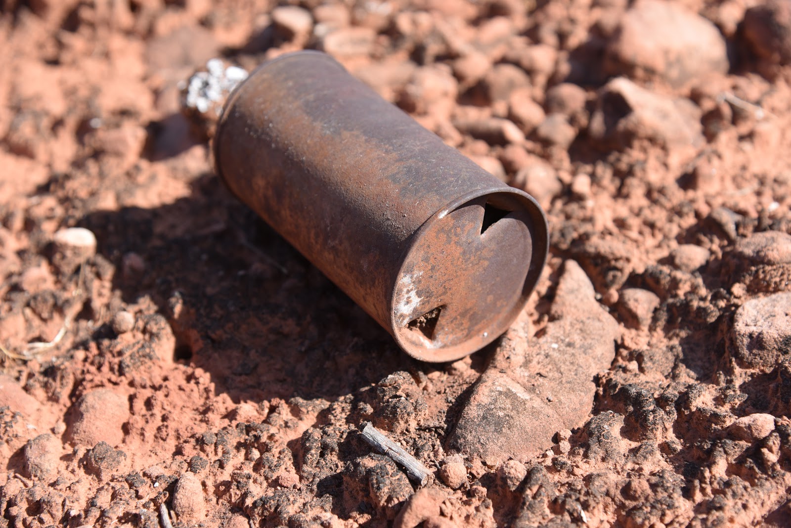
| The distinctive puncture of the church key can opener |
 |
| Big Sedona views on the Ledge-N-Airy Trail |
It’s been
more than 50 years since flat-top metal containers that required a church key opener went extinct in the mid
1960s, but in many places in Arizona’s backcountry, piles of these old-style
food and beverage cans belie the locations of defunct ranch and mining encampments. Determining the age and stories behind these
sites is best left to professionals who use the distinctive triangular pierce
mark of the church key as an index fossil of sorts in the science of can-ology.
 |
| View of Mingus Mountain from the Roundabout Trail. |
Over the years, various antiquities acts designed to protect archeologically-significant
resources on public lands have expanded to include objects as young as 50 years
old. So, although grandpa’s discarded beer
cans were once trash, those that survived the elements are now historic artifacts.
 |
| Cockscomb formation, center horizon, visible from the trails |
A few of
these rusty relic sites are visible on the new Western Gateway Trail System in Sedona.
Phase 1 of the proposed 30-mile system of fresh-cut, re-aligned and adopted user-created
trails was completed earlier this year with the help of Flagstaff-based
American Conservation Experience trail crews and funding from various organizations.
The twisted, interconnected trails wind though the hilly high desert that had
been part of the old Girdner Ranch in the area around Dry Creek and its
drainages.
 |
| Capitol Butte seen from the Outer Limits Trail |
Centered
around the old-standard Girdner Trail that begins north of State Route 89A near
Sedona Cultural Park, several routes are finessed, signed and open for
exploration. With fun names like Ledge-N-Airy, Outer Limits, Drano, Last
Frontier and Roundabout, the singletrack routes offer additional access to a pocket
of Coconino National Forest 4 miles west of Uptown Sedona.
 |
| Limestone escarpments on Ledge-N-Airy Trail |
The new routes
spin off from the Girdner and Centennial Trails and may also be accessed from the
north at the Fay and Aerie trailheads along Boynton Pass Road. For a moderate 4.6 mile hike, follow the Girdner
Trail to the Outer Limits junction, veer left, pick up the Ledge-N-Airy trail
and follow the signs to complete a loop. To see some of the rusty can
artifacts, go right at the Outer Limits junction and step out on the Roundabout
Trail. Within a half-mile, mounds of the now-protected camp litter are scattered
among cacti and scrub oaks, dissolving into the red, dusty soil. As with all heritage
sites, please do not disturb or remove anything.
 |
| Silverleaf nightshade berries on the Centennial Trail |
If you are tempted to “clean
up” the place, consider volunteering with an organization like Natural
Restorations that will teach you how to differentiate trash from treasures and to
remove refuge responsibly without disrupting the ecosystem or sensitive, protected relics. Phases II and III of
the Western Gateway project are planned for the near future and are expected to
be completed by 2021.
 |
| New trails spin off the Girdner & Centennial trails |
 |
| Historic artifacts on the Roundabout Trail |
 |
| Prickly pear fruits on the Girdner Trail |
LENGTH: 4.6 miles for the loop described here.
RATING:
moderate
ELEVATION:
4440 – 4020 feet
GETTING
THERE:
From the State Route 89A/179 traffic circle in Sedona, head
4.2 miles west (left thru the circle) on 89A to Cultural Park Way (traffic
signal). Turn right and continue 0.3-mile to the Girdner Trailhead on the
right. Trailhead has picnic tables and a map kiosk but no restrooms or water.
INFO &
MAP:
COCONINO
NATIONAL FOREST
To
Volunteer or donate to the Western Gateway project:
SEDONA RED
ROCK TRAIL FUND
To volunteer
and learn about responsible trail clean-ups statewide:
NATURAL
RESTORATIONS: