Find A Trail. Start Your Search Here:

Showing posts with label Munds Park Trail System. Show all posts

Monday, July 15, 2024

Iron Spring Connector-Leap Frog Trail

IRON SPRINGS CONNECTOR-LEAP FROG TRAIL

Hikers on the Iron Springs Connector Trail

Trails in the forests around Munds Park cater to visitors of many ilks. 

Frog Tank in the Munds Park Trail System

The slice of Coconino National Forest 20 miles south of Flagstaff is home to the Munds Park Trail System and the Kelly Motorized Trail System.  Both systems of looped trails fill the space between Interstate 17 and the Sandy’s Canyon area on Lake Mary Road with over 100 miles of recreational routes.  
Horse Park thinning project on Leap Frog Trail

Whether used for hiking, mountain biking or off-road motorized travel, the system’s menu of short and long loops makes for an ideal outdoor fun destination.  The Munds Park Trail System has several convenient trailheads located just a few miles east of Interstate 17. 
Lizard strikes a pose on Iron Springs Connector

The Iron Springs Trailhead offers quick access to the area’s most popular trails, the Mud Tank Trail and the Frog Tank Loop.  Also departing from the same trailhead, the Iron Springs Connector is a rocky two track that’s open to hikers, bikers and smaller OHVs. 
Ponderosa pines shade Frog Tank Loop

The mile-long route may be used as the first leg in any number of out-and-back or loop hikes.  The trailhead kiosk has maps showing the layout of both systems. 
Oaks and pines on Iron Springs Connector

The Munds Park trails are mostly rated as easy-moderate and are short in length while the Kelly trails are designed for OHV use and are longer and more difficult.  All the trails wander through Ponderosa pine forests with patches of sunny meadows and lots to see.
Wild bergamot blooms in moist areas

For a moderate out-and-back day hike, follow the Iron Springs Connector to the Frog Tank Loop junction.  Go right at the junction and follow the trail that’s also open to motorized use, downhill to where it crosses a drainage replete with summer wildflowers and tiny pools. 
Domestic cattle share the trails

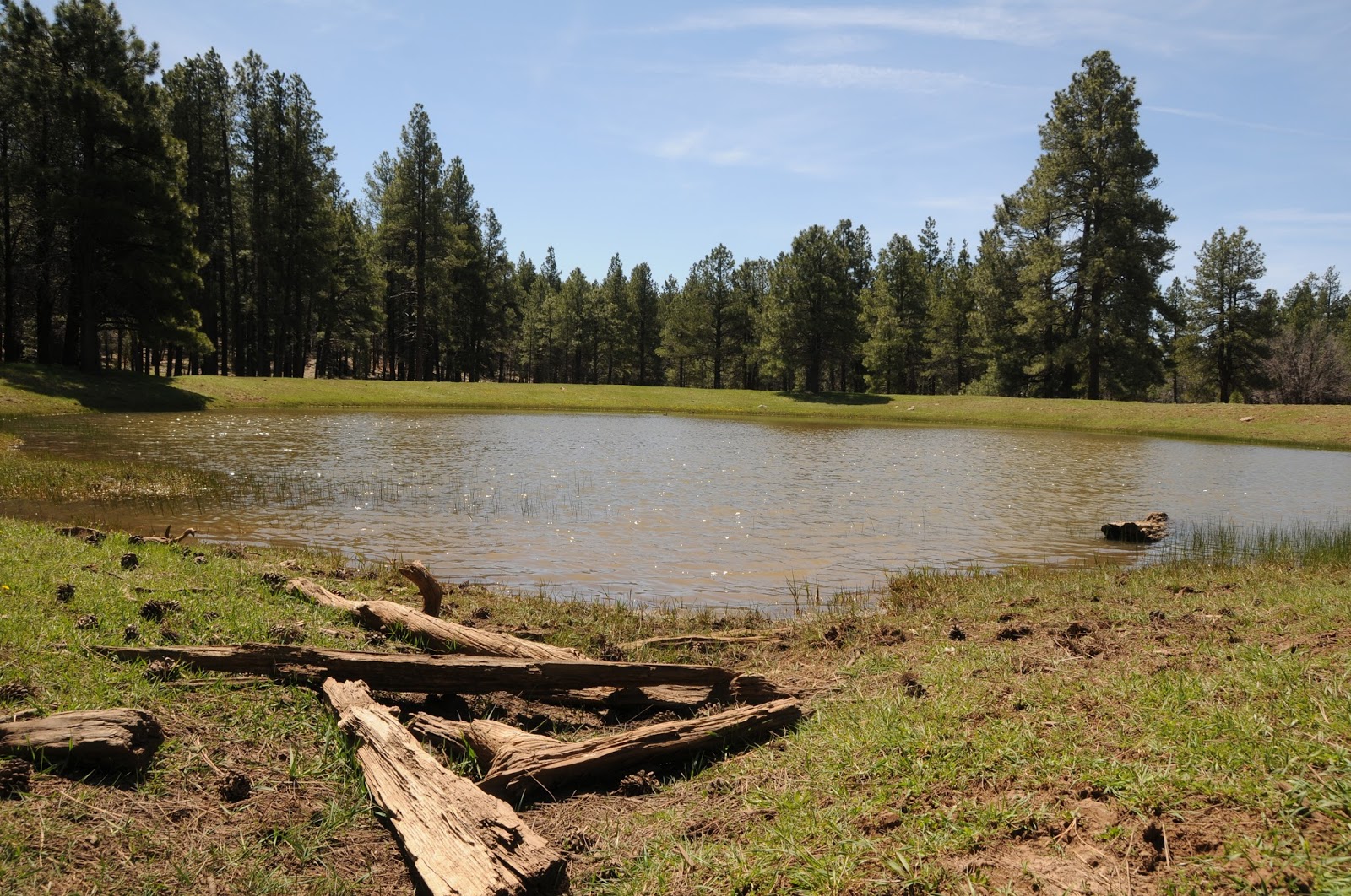
At 0.2 mile from the Frog Tank Junction, the trail meets a 3-way intersection.  Continue straight onto the Leap Frog Trail #246 which is also known as the Buried Cable Trail.  The trail is not signed here, but utility posts along this 0.3-mile segment serve as identifiers.  At the 1.5-mile point, the trail reconnects with the Frog Tank Loop.  Leap Frog trail continues north, but for a scenic detour, head left and make a 0.4-mile round trip walk to Frog Tank.  The watery enclave is a wildlife-magnet at the edge of a sunny green swale.  The pretty site attracts waterfowl, birds, elk and meandering domestic cattle. 
Apache Maid Mountain on horizon

Leap Frog Trail is a 9.5-mile route that twists north, roughly paralleling I-17 before swinging east to Connect with the Rocky Road Trail that leads to Mud Tank and back to the Iron Springs trailhead.  But for those not looking to do a half marathon style trek, a good turnaround point for a hike under 5 miles is Forest Road 78A. 
Mormon Mountain seen from Leap Frog Trail

We ventured about a half mile beyond the junction where the Leap Frog trail continues across FR78A at a nondescript Kelly Trail signpost and begins a moderate climb through the current Horse Park forest thinning project. 
Cattle graze along Leap Frog Trail

The Coconino National Forest logging project is part of an effort to reduce fire danger by removing forest fuels, restore habitats and improve forest health. Cut trees and log piles are visible long this segment. The thinning project has also opened mountain vistas. 
Wright's bluets bloom May - September

The silhouettes of 8,456-foot Mormon Mountain and 7,307-foot Apache Maid Mountain peek out from a fringe of tall pines and Gamble oaks, a sampling of what the higher elevations might have in store for strong hikers and brave ATV drivers.  
Iron Springs Trailhead in Munds park

LENGTH:  4.6 miles out-and-back to 78A as described here with side trip to Frog Tank

RATING:  moderate

ELEVATION: 6,565 – 6,625 feet

GETTING THERE:

Iron Springs Trailhead:

From Interstate 17 in Munds Park, take the Pinewood Blvd (Forest Road 240) exit 322 and continue 0.8 miles to Crestline Road. Turn left and go 0.8 miles (road will turn into Oak Dr.) to Iron Springs Road, turn right and go 0.5 mile to the trailhead.  Trailhead road is maintained dirt suitable for all vehicles. There are no fees or facilities at the trailhead.

Munds Park Trail System:

https://mundsparktrailstewards.com/maps/

Coconino National Forest Thinning Info:

https://www.fs.usda.gov/detail/coconino/landmanagement/projects/?cid=stelprdb5417804

Monday, July 27, 2020

Interstate Trail

INTERSTATE TRAIL
Canyon view point on Frog Tank Loop

If there has been an upside to the global pandemic, it has been in discovering hiking destinations that are far from the hordes. After listening to a recent radio program in which a public health expert stated that coronavirus will probably be with us “forever”, I resolved to actively knock off the outlier trails on my ever-expanding “someday” list.
Lichen and cacti grown on boulders on Interstate Trail
While many unknowns swirl around when we might once again be able to safely que up for that Instagram moment atop Sedona’s notoriously crowded Devil's Bridge, what is known is that there are plenty of areas to hike that do not require jockeying for space. One good place to find room to roam freely is in the section of Coconino National Forest that surrounds Interstate 17 near Munds Park 20 miles south of Flagstaff.
Rose hips ripen in a drainage area
Within this who-knew plot, the short, easy paths of the Munds Park Trail System serve as a launch point into the meandering routes of the 100+-mile Kelly Motorized Trail System.
Frog Tank is an important wildlife water source
The divergent shared-use routes are made up of long airy roads, repurposed railroad beds and dirt single tracks that swoop through spaces far removed from the masses and the Interstate Trail makes for a good segue into the maze.
To reach this pleasant outlier, begin at the Janice Place trailhead. Follow the access path 0.2 mile to a “T” junction at Frog Tank Loop. Before heading left to continue the hike, look for an informal footpath behind the trail sign that leads a few yards to an overlook above a drainage gorge. A peek into the stony corridor that’s cluttered with willows and brambles, is a not-to-be-missed diversion. About 0.2 mile farther down Frog Tank Loop, the trail crosses a spillway at the mouth of the mini canyon for a close up look at the water-loving riparian vegetation.
Beyond the spillway crossing, continue hiking the road to the 1.3-mile point at Frog Tank where a connector trail that leads to Forest Road 78A veers off to the left.  Take a few minutes here to check out the tank which serves as an important water source for waterfowl, deer, elk, myriad little critters and a vociferous flock of mountain bluebirds.
From the tank, follow the signs 0.1 mile to Forest Road 78A, cross it and pick up the Interstate Trail which is marked with a Kelly Motorized Trail System sign.
Gambel oaks arch over Interstate Trail
The route is open to motorized use, but its narrow cut appears only wide enough to accommodate dirt bikes. This simple north-south route makes a twisted course that runs parallel to Interstate 17 for roughly 7 miles ending just south of the Kelly Canyon area.  Although the trail is located only a mile east of the freeway, the hilly terrain and thick tree cover muffles most of the noise. 
Hike begins at the Janice Place trailhead in Munds Park
 
It’s a mostly easy walk that ducks among ponderosa pine and exposed spreads of alligator juniper and high desert cacti with intermittent mountain vistas.  But the most underappreciated and fascinating sights along this trail can be found growing on outcroppings of volcanic rocks.  Lichens, crusty-looking composites of fungi and algae, form a sort of natural art gallery of colorful splatters, leafy medallions and web-like masses that cling to rock surfaces like layers of old paint.
Beginning of the Interstate Trail
Sometimes found growing alongside mosses, the microscopic organisms that exist through a symbiotic relationship of creating and sharing nutrients are also essential to forest and environmental health.
Redroot buckwheat is a common summer bloomer
The odd organisms contribute to soil building by helping break down rock and absorb pollutants from the atmosphere.  Although they may appear “dead”, lichens have remarkable survival skills and can spring back to life after rains. Growths of the blue-green, gold and rust-colored curiosities are abundant along the trail.  No two are alike.
Winged buckwheat blooms July - October
Interstate Trail is a twisting single track route
Willows, wild grapes and roses thrive in a drainage
Lichen clings to a boulder on Interstate Trail
Because an incoming thunderstorm was moving in from the north, I decided to turn around after just 3 miles on the Interstate trail. But, with several more miles left to explore, I will return after a few good storms wet the area enough to coax the lichen back to life. 
Interstate Trail is accessed via Frog Tank Loop
LENGTH: 8.6 miles roundtrip (as described here)
RATING: moderate
ELEVATION:  6,446 – 7,000 feet
GETTING THERE:
Janice Place trailhead:
From Interstate 17 in Munds Park, take the Pinewood Blvd. exit 322. Turn right and follow Pinewood Blvd. 0.1 mile, turn left on Fairway Drive (which will turn into N. Lodge Dr.) continue 0.3 mile to Janice Place, turn right and go 0.2 mile to the trailhead on the left.
INFO & MAPS:
ABOUT LICHENS:

Thursday, May 14, 2020

Munds Canyon Trail to Horse Park

As forests and recreation sites start to reopen, please continue to observe safe practices as you begin stepping back out on the trails. Here's another less-used gem where there's room for physical distancing.

MUNDS CANYON TRAIL to HORSE PARK
Water lingers at the bottom of Munds Canyon

In the pine forests that straddle the hilly acres between Lake Mary Road and Interstate 17 south of Flagstaff, a network of shared-use trails connect Arizona’s plateau lakes region with the community of Munds Park. 
There's lots of shade on the Munds Canyon Trail
The system of long, loopy routes is integrated with the Kelly Motorized Trail System and forest service trails adopted by the Munds Park Trail Stewards (MUTS), a volunteer group dedicated to working with land management agencies for the establishment and maintenance of multi-use trails in the Coconino National Forest.
Watch for wildlife near a tank along Rocky Road Trail
With over 100 miles of new and re-purposed trails, the Munds Park-Kelly Canyon Trail System provides recreational access with the goal of preventing destructive trailblazing while preserving access and forest health.
Woodhouse's Phlox blooms spring through fall
Over 100 miles of trails in the Kelly-Munds Park systems
Munds Park - Kelly trails are multi-use
The route is well-signed and easy to follow.
Open to hikers, bikers, equestrians and smaller motorized vehicles, the Munds Canyon Trail 240 is a pleasant walk through shady terrain that dips and climbs through the contours of a shallow gorge.  The 2.3-mile route  is well-maintained and signed and may be used in conjunction with several connecting trails for longer treks. Beginning at the roomy Pinewood trailhead where there’s plenty of parking for vehicles and trailers, the hike begins with an easy walk through pine-oak woodlands and meadows. The trail soon encounters the edge of Munds Canyon where a series of flowing switchbacks glide off the rim and into green drainages cluttered with brambles and wildflowers that thrive in the moist ecozones. 
Larkspur grow in pine forest clearings
Munds Canyon Trail ends at the junction with the Rocky Road Trail 241. Turn back here for a 4.6-mile hike, or head right on Rocky Road for a longer adventure with a few surprises thrown in.
An odd sinkhole stands out on the Rocky Road Trail
This section of Rocky Road lives up to its name with lots of loose stones that make foot travel manageable but potentially ankle-twisting. Watch your step and you’ll be fine. At the 2.9-mile point, the trail crosses a cattle guard and meets a massive sinkhole. The abrupt, boulder-jumbled crater looks strangely out-of-place among tracts of arching oaks and colorful blooms.  Not far beyond the stone pit, a noticeable increase in wildlife activity—birds, squirrels, fox, racoon, elk-- hints at the presence of a water source.  Watch for a large earthen berm off to the left which contains a wildlife water tank that attracts dozens of animal species such as skunk, herons and bobcats. During the final half-mile of the hike, the forest opens up as it enters the sunny grasslands of Horse Park.
Pine thermopsis blooms April - July
The Munds Park Trail Stewards recently constructed log fences to keep motorized traffic out of the previously damaged sensitive environment. To help in its recovery and to keep from disturbing wildlife, even hikers should respect nature by staying on designated trails.  Trails and campsites are for people. The rest of the forest is for plants and animals. 
Munds Canyon Trail descends into a forested draw
Fencing protects the recovering flats of Horse Park
Even minimal foot traffic can disrupt fragile habitats.
Rocky Road Trail is rocky, as advertised.
Lemmon's Star blooms spring through early summer
Rocky Road Trail meets Forest Road 700 at the 3.9-miles, the turnaround point for this hike.
LENGTH: 7.8 miles round trip
RATING: moderate
ELEVATION: 6,646 – 6,955 feet
GETTING THERE:
From Interstate 17, take the Munds Park exit #322 and continue 2 miles east on Pinewood Boulevard (Forest Road 240) to the parking area on the left.  Trail begins at the north end of the lot. Roads are paved with a short section of maintained dirt that's fine for all vehicles.
INFO & MAPS:


Monday, April 16, 2018

CRYSTAL POINT TRAIL

CRYSTAL POINT TRAIL
First glimpses of Sedona on the way up to Crystal Point
Cut into a gentle ridgeline where the red rock marvels of Sedona melt into Flagstaff’s tall pines and mountainous terrain, Crystal Point Trail provides a taste of both worlds.
Franciscan Bells decorate the trail
The trail has been adopted by the Munds Park Trail Stewards (MUTS), an organization that maintains recreational routes around the community.  Thanks to volunteer workers who perform regular maintenance, the trail is neatly brushed, signed and switchback-mitigated.  The non-motorized path makes an easy climb through pine-oak woodlands, meadows and edges bolstered by lichen-encrusted boulders.  Even in dry years, high-country wildflowers like brilliant blue Franciscan Bells add pops of color in sunny spots along the way. The trail’s appeal is rooted in its birds-eye glimpses of Sedona that begin to appear through the trees about a half-mile into the hike. 
Summit ammo boxes hold trail log books for hiker notes
Views of rusty escarpments layered with white limestone that stand above the green valleys of the Verde River watershed gain in scope as the route makes its way to Crystal Point.  
Views of Sedona from Crystal Point
The trail tops out on a knoll at the 1.3-mile point where a picnic table with ammo boxes full of hiker logs invites visitors to stay awhile, enjoy the sights and peruse the inspiring—sometimes weird—comments scrawled in dog-eared notebooks.  While some hikers are satisfied to call this the turnaround point, it’s not the end of the trail.  The journey may be extended by continuing down the ridge toward Odell Lake. 
Munds Park Trail Stewards maintain the route
This 2.5-mile segment descends on lazy bends offering even better views than those seen on the summit. 
Wood betony
Once off the hill, the trail follows a wide ravine to the lake. A dry winter has not been kind to Odell Lake. The shallow reservoir has shrunk to a collection of muddy pools. Still, the area near the water teams with birds and waterfowl.  The path ends at a gate in a residential area at the end of Golden Lake Trail.  
Oak buds

View from the switchbacks
Although it might be tempting to explore around the lake, much of the land is private property, so be respectful.
From trail’s end, you could make a loop by hiking 1.3 miles on paved streets back to the trailhead, but it’s not very interesting.  Instead, head back the way you came for a rewind viewing of a pleasant show. 
LENGTH:  3.3 miles one way
RATING: moderate
ELEVATION:  6480 - 7190 feet
GETTING THERE:
From Interstate 17, take the Munds Park exit #322 and continue 2 miles east on Pinewood Blvd (Forest Road 240) to the parking area on the left.  Trail begins across the road. Roads are paved with a short section of maintained dirt that's fine for all vehicles.
INFO & MAPS:

Monday, April 24, 2017

MUD TANK TRAIL, BRAD'S TRAIL & FROG TANK LOOP

MUD TANK TRAIL, BRAD'S TRAIL & FROG TANK LOOP

Munds Park Trail System
Mud Tank
Just off Interstate 17 a few miles south of Flagstaff, a mix of Coconino National Forest roads and footpaths have been adopted by the Munds Park Trail Stewards-- a non-profit organization that maintains and builds recreational routes around the mountain community. The Munds Park Trail System offers a varied menu of both ATV and hiker options enhanced with a plethora of eye candy and points of interest.
Typical scene on the Mud Tank Trail
The Iron Springs Trailhead serves as the system’s nerve center with a map kiosk showing an overview of the entire matrix as well as providing a launch point for the Mud Tank Trail, Brad’s Trail and Frog Tank Loop.
A good way to get warmed up before exploring the system’s longer routes is to step out on the Mud Tank Trail.  This effortless walk among Ponderosa pines is open to hikers, bikers and equestrians and culminates at a stock pond. The watering hole is a quiet, pretty place surrounded by oak trees and a muddy fringe of animal footprints. A stroll along its perimeter reveals the signatures of elk, deer, raccoons, birds and the familiar impressions of dog paws. You’ll want to hang out for a while to absorb the songs of Mountain bluebirds and Stellar’s jays riding on pine-infused breezes before heading back to the trailhead to pick up Brad’s Trail. Named for forest service volunteer Brad Bunsell (1958-2011) who, according to a tribute at the kiosk, never met a rock he couldn’t move, the path serves as a non-motorized connector to the Frog Tank Loop.
Frog Tank
The mile-long trail is also the main artery for paths that access private communities. Look for directional signage tacked to trees to stay on course. The Frog Tank Loop junction marks the beginning of a delightfully irregular, 3.1-mile trip through thick, coniferous forests, sunny meadows and scenic water features. Heading right from the junction, the route descends on a rugged shared-use road to meet the distressed channel of an intermittent stream.
Meadow on the Frog Tank Loop
Keep an eye out for motorized traffic while ogling the eroded banks, reflecting pools and trickling rivulets. The loop connects to a maze of forest roads that can cause confusion if you’re not paying attention. Just look for the Frog Tank Loop signs at each intersection and you’ll be fine. As the trail swings westward, it emerges into a moist, green pasture that drains into Frog Tank. Only foot traffic is allowed around the pool’s sensitive berms, so travel lightly or better yet, take a break beneath one of the massive trees on the perimeter and try to spot some of the animals that come there to drink and swim.
Pine Thermopsis bloom April through July
Beyond the tank, the trail crosses a canyon-bound waterway cluttered with high-country wildflowers like Pine Thermopsis and wild roses before heading uphill to a point just above the steep-walled passage. Once at the top of the climb, look for a couple of spur paths leading to the lip of the gorge. Carefully peer over the edge for dizzying glimpses of vertical basalt walls and a log-jammed creek. Around the next bend, community paths and cabin rooftops signal the end of the loop where you'll backtrack on Brad’s Trail to the start point.

Intermittent stream on Frog Tank Loop
LENGTH:
Mud Tank Trail: 1.6 miles roundtrip
Brad’s Trail: 2 miles roundtrip
Frog Tank Loop: 3.1 miles
RATING: easy-moderate
ELEVATION: 6500’ – 6700’
Sign on Brad's Trail
GETTING THERE:
Iron Springs Trailhead:
From Interstate 17 in Munds Park, take the Pinewood Blvd (Forest Road 240) exit 322 and continue 0.8 miles to Crestline Road. Turn left and go 0.8 miles (road will turn into Oak Dr.) to Iron Springs Road, turn right and go 0.2 mile to the trailhead gate. Park along the street, pass through the gate and hike 0.3 mile to the big trailhead kiosk.
INFO: