DIRTYNECK ROAD
Near Clints Well
 |
| Ferns galore |
While attempting a less-than-successful exploratory hike on
the Mogollon Rim this past week, we stumbled upon this easy dirt road hike on
the western lip of Dirtyneck Canyon (see separate blog entry for the canyon hike).
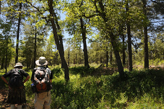
Because it's situated in an area that gets lots of moisture runoff and
lingering snow, the route is smothered in healthy oaks and oceans of whispering
ferns. A stock tank roughly halfway
in is the pub of choice for local forest beasts that leave their impressions
along its muddy fringes. Look for signatures of elk, raccoon, possum, skunk, rabbit, squirrel, deer, and the meandering
scribbles of traveling caterpillars on the "critter dance floor". Beyond the tank, the road dips downhill to emerge in the impossibly
green meadows of Fortynine Canyon---it’s an unsigned junction where FR6089 goes
right. This is easy to miss---look
for a 4x4 road going up a steep embankment on the left, the route heads right
(northeast) directly across and continues for just under a mile to AZ87. However, if you want an extra treat,
head left into Fortynine Canyon. Here, the road follows a moist drainage leading to a spring
and a group of old cabins resembling a tiny pioneer hamlet. If you go this way, the road bends
north near the cabins and ends at AZ87.
LENGTH: 6 miles roundtrip
RATING: easy
ELEVATION:
7385' - 6923'
DISTANCE FROM PHOENIX: 90 miles 1-way (from Shea Blvd. &
AZ87)
GETTING THERE:
From Phoenix, go north on AZ87 (Beeline Hwy) to Payson. Continue north on AZ87 past
Pine-Strawberry to the junction with AZ260. Set your odometer.
From here, north on AZ87 to FR 613 on the right--this is
roughly 2.5 miles north of FR300 Rim Road and between mileposts 282 and
283. Turn right and follow FR
613 0.8 mile (veer left at
the Fortyfour Canyon sign) to
where there are signs for "Dirtyneck Canyon" and FR6089 on the left.
Park in the pullout and hike north on FR 6089.
MORE PHOTOS:
https://www.facebook.com/media/set/?set=a.4170806247190.1073741854.1795269672&type=1&l=c94d2d5bed
MORE PHOTOS:
https://www.facebook.com/media/set/?set=a.4170806247190.1073741854.1795269672&type=1&l=c94d2d5bed


