DAWA LOOP
“Where’s Fay Canyon,” the bewildered couple asked of me on the Cockscomb Trail. “Across the road from the trailhead,” I replied.
 |
| Conifers shade a crossing of Dry Creek |
With the faint aroma of marijuana drifting from their air space, they added, “Thanks, that’s the trail we want. This one stinks.”
Stinks? Being one who picks her fights, I let the offhanded dis roll, bid them a good day and continued hiking on one of the best “stinky” trails in Sedona.
 |
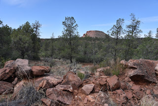
| View of Doe Mountain from Cockscomb Trail |
While Fay
Canyon and the many other classic trails like Doe and Bear Mountains located along
Boynton Pass Road in northwest Sedona are terrific, so are the dozens of routes
that mill around the canyon-riddled landscape below the iconic big-name draws. Barberry shrubs bloom Apr-Jul
Offering quieter, less congested tours of Sedona’s
spectacular scenery, the trails that explore the woody terrain around Dry Creek
serve up myriad high-desert hike options.
New Mexico locust bloom May-July
Like many Red Rock Country trails, the cluster south of Doe Mountain are
short, interlaced and designed for easy customization.
 |
| The route crosses Dry Creek several times |
 |
| The Ok Trail traces a ledge above Dry Creek |
Excellent map signs posted at trailheads and along the trails make it easy to plan a hike to suit individual preferences. There are no bad choices. None stink. One circuit to try uses the Cockscomb, Dawa, Ok and Arizona Cypress trails for an interesting lollipop loop. From the Fay Canyon trailhead, head out on the Cockscomb Trail.
 |
| Tufted evening primrose bloom Apr-Nov |
This 0.9-mile tether trail passes through sunny meadows and rolling hills with great views of Doe Mountain to the west and Mescal Mountain on the northeast horizon. where At the signed Dawa Trail junction, veer left to begin the first leg of the hike’s loop segment.
 |
| Cockscomb formation seen from Dawa Trail |
Here, mountain views begin to recede as vegetation thickens with pinon pines, cypress and New Mexico locust towering over prickly barberry shrubs. The first of several crossings of Dry Creek, which usually lives up to its name, comes just before the 1.7-mile point, where the route turns right onto the Ok Trail. Over its shady, 0.2-mile length, the Ok Trail traces the ledges above the creek before it meets the Arizona Cypress Trail.
 |
| A late-blooming Strawberry hedgehog cactus |
At the junction sign, continue straight ahead, past a huge Arizona Walnut tree to where the trail makes another crossing of the creek. Strewn with colorful river rocks and tumbled pebbles, the creek channel here includes a ragged wall of scoured red earth.
 |
| Desert four o'clock bloom Apr-Sept |
 |
| Engelmann's prickly pear cacti bloom Apr-Jun |
Living up to its name, the Arizona Cypress Trail is lined with hundreds of the eponymous shaggy-bark conifers, including a massive, decaying specimen just past the creek cross.
 |
| Mescal Mountain (center) seen from Dawa Trail |
It takes at three-person chain to hug the trunk of the not-quite-totally-dead tree. Look closely and you’ll see a few living branches sprouting from the last viable sapwood of the ancient tree.
 |
| Narrowleaf penstemon bloom Jun-Aug |
This mostly viewless leg of the route parallels the creek for a half-mile, then reconnects with the south arm of the Dawa Trail. As the path climbs out of the creek channel, it unpacks a fresh set of vistas.
 |
| The Arizona Cypress Trail lives up to its name |
To the southeast, the familiar forms of Courthouse Butte, Capitol Butte and Chimney Rock stand out above green canopies. Gradually, the close-knit creekside greenery gives way to exposed ridges where cacti, wildflowers and blooming shrubs thrive in red-tinged soils.
 |
| Teeny-weeny Miniature wool star bloom Mar-Jun |
In just under a mile, the route returns to the first Dawa Trail junction, where you’ll retrace your steps on the Cockscomb Trail back to the trailhead or use the map signs to add more miles.
 |
| Map signs make navigation easy |
LENGTH: 4.2-miles
RATING: easy
ELEVATION: 4,334 – 4,569 feet
GETTING THERE:
Fay Canyon Trailhead.
From the State Route 179/89A traffic circle in Sedona, veer left and go 3.2 miles on SR 89A to Dry Creek Road. Turn right and continue 4.5 miles on Dry Creek Road to the Boynton Canyon Road intersection, turn left onto Boynton Pass Road and go 0.5-mile to the trailhead on the left. There’s a restroom at the trailhead. A Red Rock Pass is not required.INFO:https://www.fs.usda.gov/recarea/coconino/recarea/?recid=54974


