Find A Trail. Start Your Search Here:

Saturday, October 6, 2012

Flagstaff fall color update, Oct. 6, 2012: HURRY!


Flagstaff fall color has arrived fast and furious for 2012.  What a difference from 2011 when peak foliage color dilly-dallied until mid-October.  Not so this year.  The high elevations (above 10,000')  are already past peak in many spots, while mid-high locations (8,000'-9,000') are at peak NOW.  We drove Hart Prairie Road (7,000') today and observed that it's approaching peak color.  Hurry.
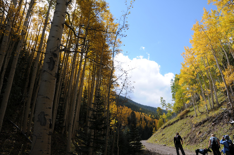
Bear Jaw Trail, 8,600', Oct 6, 2012

ABINEAU-BEAR JAW LOOP
Flagstaff
Past prime aspens at 10,000', Oct 6, 2012
An October drive up Flagstaff's Highway 180 reveals views of golden aspens on the lofty slopes of the San Francisco Peaks.  Yes, the first showings of autumnal color bloom up high, so to hike among leaves that blaze like day-glo paint you must climb the north face below Humphreys Peak.  There's a, app trail for that---Abineau-Bear Jaw Loop.  This rugged route begins in an innocuous alpine meadow but soon enters avalanche-scarred coniferous-aspen woodlands for a steady climb (unmitigated by switchbacks) that leads to a both-kinds-of-breathtaking ridge (10,280') below Arizona's tallest peak.  Here, the wind-addled tundra-like landscape is dotted with stands of white firs framing views of Northern Arizona's volcanic highlands. Beyond this highpoint, the route follows the serpentine path of Waterline Road where willowy aspens rustle and flourish along its flanks.  Whereas the Abineau leg of the loop is mostly about pines, spruce and fir, the Bear Jaw return is all about aspens, with glens so thick they mimic whiteout conditions. Here, on the downhill trek, mountain-borne breezes kick up flurries of heart-shaped leaves from the canopies into eddies of gold that tickle the air and carpet the forest floor.  It's really an awesome spectacle. 
HIKE DIRECTIONS:
Hike 0.4 mile on the access trail and turn right to begin on the Abineau Trail---which gets the climbing over quickest. Hike 1.9 miles uphill to the junction with Waterline Road (sign says no access to Humphreys Peak). Turn left here and hike 2.1 miles to the signed turn off for Bear Jaw Trail on the left.  Follow Bear Jaw 2.4 miles back to the first junction and retrace your steps 0.4 mile back to the trailhead on the access path. 
Bear Jaw Trail, 8700', Oct. 6, 2012

LENGTH:  7.2-mile loop
RATING: difficult
ELEVATION:  8530' - 10,280'
GETTING THERE:
From Flagstaff, travel north on US180 (Fort Valley Rd) to milepost 235.2 and turn right onto FR 151 (Hart Prairie Road, north access).  Continue 1.6 miles on FR 151 and connect to FR 418.  Drive 3.1 miles on FR418 to FR9123J  (signed for Abineau-Bear Jaw), turn right and go 0.6 mile to the trailhead.
Roads are semi-okay dirt, passable by carefully driven sedans. 
Near the top of Abineau Trail, Oct. 6, 2012
INFO:  Flagstaff Ranger District, Coconino National Forest, 928-526-0866
FALL COLOR INFO & UPDATES:
MORE PHOTOS:

Thursday, October 4, 2012

Fall color update: Mogollon Rim, Oct 4, 2012


Fall foliage is just beginning to emerge on the Mogollon Rim.  Today we noted lots of sulfur yellow in Boxelders, spotty groves of amber oaks and gold-kissed aspens on..... 
Oak color, October 4, 2012

HOUSTON BROTHERS TRAIL #171
Mogollon Rim
Wild geranium
The densely wooded terrain of the Mogollon Rim is riddled with water-sculpted canyons and bizarre fossiliferous limestone formations.  The fractured earth makes for an interesting mix of flat-floored forests and steep gorges where water collects and cool air settles in pockets of perennial, mossy dampness.  These secluded, moist microclimates feed communities of Big-tooth maples, willows, boxelders and oaks that burst out in flaming color palettes when nudged by the cool nights and low light of early autumn.  The Rim’s Cabin Loop system of trails wiggles among spring-fed meadows and water harboring draws that play host to autumnal splotches of honey-and-crimson-colored foliage. The best part about Rim country fall color is its relative rarity---it pops up willy-nilly  among the pines and firs making each "find" feel more special than the last.  Cabin Loop trails Barbershop, U-Bar, Fred Haught and--as we visited today---Houston Brothers--all dole out visually delicious color spots that add elements of treasure hunting thrills to the routes.
Fall color at Aspen Spring, Oct 4, 2012

LENGTH:  7 miles one-way
RATING: easy. follow the tree blazes where the path is faint.
ELEVATION: 7,000'-7,774'
GETTING THERE:
TRAVEL ALERT 10-5-2013: FR95 is closed between FR139G and 139A to repair the culvert over Houston Draw.  Do NOT attempt to drive thru---it's a major wreck.  You can park at FR139G and hike 0.5 mile on FR95 to the Fred Haught Trailhead or drive in from Rim Road instead.
From Payson, travel north on AZ87 (Beeline Hwy) to Clint's Well.  From here, continue 9.4 on AZ87 to just before milepost 300 and turn right onto FR95.  Follow FR95 6.5 miles to a bridge over East Clear Creek and veer right to stay on FR95.  Continue 4.5 miles to FR139A (a few yards past a sign for Houston Draw), turn left and go 0.2 mile to the trailhead marked by a sign for Fred Haught Trail.   Roads are good gravel/dirt with winding mountain grades—sedans okay.
INFO: Mogollon Rim Ranger District, Coconino National Forest

Sunday, September 30, 2012

FLAGSTAFF FALL COLOR


INNER BASIN
Flagstaff
Entering Inner Basin, Sept. 29, 2012

It’s aspen overload time on Flagstaff’s Inner Basin Trail. This week should be the PEAK TIME to hike this trail, which twists uphill from beautiful Lockett Meadow, through corridors of white-barked aspens and then takes on an unrelenting uphill slog to a point on the Weatherford Trail where you can look back down on the route. Offering unsurpassed views of golden color from below, within and above, you’d be hard pressed to find a better trail for aspen leaf peeping. 
Inner Basin, Sept. 29, 2012
View of Inner Basin from Weatherford Trail
In addition to the glorious autumn color show, majestic lava-born slopes surround hikers with avalanche paths streaming from the desolate tundra above tree line into quiet aspen-and-fir ringed meadows thousands of feet below. For a fall color hike, it would be easy to get your fill within a few yards of the trailhead---but what's the fun in that?  The first 1.6-mile segment climbs 800 feet on a slender dirt path then merges with a wide, dirt service road.  It's here where the climb enters "spring alley" and becomes more difficult.  Jack Smith, Raspberry and Doyle springs are located close to the trail and make convenient breath-catching distractions. I usually bring a small empty bottle to fill at the spigot where untreated spring water runs spordically.  This area is the primary water source for the City of Flagstaff and you'll pass several maintenance buildings along the trail.  Past the buildings, the trail enters Inner Basin proper for wide-open vistas hemmed in by the San Francisco Peaks.  Beyond the Basin, the trail leaves the aspens behind and begins a grueling ascent through forests of white pine and Douglas firs.  The final .25-mile is marked by a series of switchbacks leading to Weatherford Trail and a beautiful scenic ridgeline with great views of the Painted Desert and the aspen forests below. We returned the way we came, however, if you're feeling energetic, you can continue another 3.5 miles and 1,643 feet to the roof of Arizona ----12,633' Humphreys Peak.


LENGTH:  4 miles one way
RATING: easy, then difficult
ELEVATION: 8,600' - 10,990'

DISTANCE FROM PHOENIX: 165 miles
GETTING THERE:
From Phoenix, travel north on I17 to the I40 junction in Flagstaff.  Head east on I40 and connect with US89 north.  Continue 17 miles north on US89 to FR 420 at milepost 431.2  (across from the turnoff for Sunset Crater).  Turn left here and veer left onto FR 552, following the signs 4.5 miles to Lockett Meadow.  The good gravel roads are narrow and winding with steep drop offs and no guardrails. Sedans okay, drive slowly and watch those curves. Trailhead parking is just past the campground.
FACILITIES: restrooms, camping (fee area), trailhead parking is free

INFO: Flagstaff Ranger District, Coconino National Forest, 928-526-0866
MORE PHOTOS: