Find A Trail. Start Your Search Here:

Showing posts with label Highline Trail. Show all posts

Monday, July 22, 2019

See Spring

SEE SPRING
Water rushes from a crevice at the head of See Spring
On the jagged cliffs below the Mogollon Rim, dozens of springs dispense water that filters through the porous limestone escarpments.
The hike begins with an easy crossing of Christopher Creek 
The springs range in flow from steady trickles that drain into green seeps to icy founts that gush from solid rock, carving gullies and fostering thick forests.
  See Spring is one of the later. Its location half-a-mile off the See Canyon Trail along Christopher Creek in Tonto National Forest twenty miles east of Payson makes it a popular choice for a short day hike or add-on to the 2.5-mile mile artery route that climbs over 1700 feet to the top of the Rim.
There’s a local hiker adage that claims when trekking See Canyon, all you see is the canyon. This is mostly true, but, oh, what a canyon it is to behold. 
New Mexico locust grow in dense thickets on the trail.
Dense woodlands shade the See Canyon Trail
Right out of the chute, the trail delivers a rich palette of sights and sounds plus enough challenge (or not) to satisfy a full gamut of hiking styles. You don’t have to walk very far before becoming immersed in the perennial flow of Christopher Creek and the lush woodlands that thrive in its moist environs. 
Christopher Creek is a main feature of the trek.
Boxelder trees love the moist environs near See Spring
The journey begins with a brief walk on the Highline Trail. From the trailhead, follow the footpath to where a pair of white diamond symbols tacked to trees indicate where the route makes an easy crossing of the creek. On the opposite bank, walk a few yards and veer left at the See Canyon Trail junction. The next half-mile traces the stream through a mix of meadows and forests of New Mexico locust, boxelders and Ponderosa pines. Beneath the leafy canopy, healthy tangles of canyon grape vines mingle with insidious clumps of poison ivy--leaves of three, let it be.
Canyon grapes flourish in moist areas on the trail.
It’s smart to wear long pants on this hike to avoid getting an itchy rash.
Mountain vistas are sparse, but water features are plentiful
The path crosses several rocky drainages as it gently gains elevation to reveal glimpses of Promontory Butte, a major Rim land feature.  At the 0.8-mile point, head right at the See Spring Trail junction where the half-mile spur path swerves away from the creek and begins a moderate climb.  
Bigtooth maples filter sunlight on See Spring Trail
The “all you see” adage really hits home here as thick stands of Bigtooth maples, Gamble oaks, Alligator junipers, Arizona walnut and soaring Douglas and white firs choke the trail into a shady, slim passage obscuring all but sky and vegetation.  A few sets of switchbacks mitigate the 400-foot ascent that lands hikers in an enchanting natural water park setting.
Tree cover on the See Spring Trail
Roughly 1.3 miles from the trailhead, the first signs of the See Spring conglomerate of waterworks appear as jumbled ravines funneling crystalline streams.  Follow the faint footpaths another 0.2-mile and you’ll arrive at the spring source where water pours from rock crevices all around.
Golden-beard penstemons add brilliant color to the trek.
The splashy rhythms of water rushing over mossy boulders and flattened ferns complemented by bird calls and rustling leaves combine for a calming culmination of short trek with much to see. 
Scampering lizards are constant companions on the trail
See Canyon-See Spring junction
You're never far from water on this Mogollon Rim classic
See Canyon Trail traces Christopher Creek
Icy water spills from See Spring
Poison ivy. Leaves of three, let it be.
LENGTH: 2.6 miles roundtrip (5 miles with See Canyon Trail)
RATING: moderate
ELEVATION:  6106 – 6725 feet (7860 feet with See Canyon Trail)
GETTING THERE:
From Payson, go 20.2 miles east on State Route 260 to the Christopher Creek Loop exit, turn left and continue 1 mile to Forest Road 284 (across from the Tall Pines Market), turn left and go 1.6 miles to the trailhead. Access road is good dirt/gravel suitable for all vehicles. There’s a restroom at the trailhead.
INFO:


Monday, July 23, 2018

MILITARY SINKHOLE TRAIL

MILITARY SINKHOLE TRAIL
View from the Rim Lakes Vista Trail
About halfway up the Military Sinkhole Trail, I thought of Michael Corleone. In a memorable scene from the 1972 film The Godfather, protagonist Corleone rebuffed a ride as he approached his ancestral Sicilian village for the first time, deciding to savor the experience by walking to it instead. I get it.
Mixed conifer woodlands on Military Sinkhole
There’s a sort of reverence associated with trekking to special places. A slower, boots-on-the-ground pace syncs well with epic experiences. Like the village of Corleone, the Mogollon Rim is a place best crept up to on foot.
Arizona Thistle grow in Rim-top meadows
The Rim is a roughly 200-mile escarpment at the edge of the Colorado Plateau that runs east-west across central Arizona.  It’s easy enough to drive right up to its precipitous cliffs and take an edgy, 40+-mile motor tour along Rim Road 300, but to get a better sense of the scale and structure of this geological wonder, you need to climb it from base-to-ceiling.
Shady forests define the Military Sinkhole Trail
One of the most convenient ways to do this is to hike up the Military Sinkhole Trail. 
One of many soulful sights on Rim Lakes Vista Trail.
Located 27 miles east of Payson on State Route 260, the historic route makes an aggressive, 850-foot ascent to scenic ledges on the top of the Rim. The multi-faceted route begins with a walk through deep, mixed-conifer woodlands of the Tonto National Forest. Shaded by enormous Douglas firs with their characteristic barbed cones, spruce and pines, the first mile is a cool and gentle climb.
There's little shade, but great views, on parts of the trail.
Top of the Drew Trail
Where the trail dips into drainages, canopies of Bigtooth maples cast filtered sunlight on moss-embellished boulders and mushrooms popping through carpets of pine needles and cracks in decaying logs. (Keep this one in mind for a fall foliage hike.) Beyond the maples, the forest thins out, emerging onto an exposed ridge to merge with an abandoned military road built by General George Crook in the 1870s.  Like many old roads in the area, this one plows uphill without the benefit of climb-calming switchbacks. 
Butterfly on Gregg's Ceanothus shrub.
It’s a rocky, quad-burning segment with little shade, but great views of the Mazatzal Mountains and green valleys mitigate the pain.
Defunct military road built by Gen. George Crook.
The ankle-twisting road gradually levels out as it enters a corridor of arching Gambel oaks and fields of bracken ferns.  At this point, vertical walls start to flank the trail, hinting at the enormity of thrills that follow. 
Bigtooth maples thrive in moist drainages.
With the hardest parts over and the jumbled cliffs of the Rim’s edge hovering above, the trail enters the Apache-Sitgreaves National Forest for the final slog to the top.  At a signed junction just below Rim Road, Trail No. 179 continues straight ahead on a not-very-interesting path that connects with the General Crook Trail.
Limestone escarpments flank the final slog to the top.
 To reap the rewards you came for, head west (left) at the junction and follow Rim Lakes Vista Trail No. 622.
Keep this trail in mind for fall foliage hiking.
After a short traipse through a flowery meadow, breathtaking vistas and refreshing mountain breezes overwhelm the senses. 
Ferns grow waist-high in damp spots below the Rim.
The tough pilgramage culminates at scenic overlooks that frame wildland views. Here, hordes of camera-toting visitors stream from parked vehicles to stroll a few yards from the road for the same result.  However, regarding this experience; hiking is to driving as a clarinet is to a kazoo.  
Hooker's Evening Primrose blooms close by noon.
After savoring your hard-won eye candy, head back the way you came, or make an 11.7-mile loop by continuing 3.3 miles on Trail No. 622 to the Drew Trail No. 291.  Head 1.8 miles downhill to Highline Trail No. 31, turn left and hike 4.1 miles back to the trailhead.
A particularly fragrant section of the Military Sinkhole Tr.
A distinctively-barbed Douglas fir cone
LENGTH: 5 miles up-and-back or 11.7-mile loop.
RATING: moderately difficult
ELEVATION: 6750 – 7600 feet
GETTING THERE:
Two-Sixty Trailhead (SR260):
From Payson, go 27 miles east (right) State Route 260 to the “Two Sixty” trailhead turn off on the left. Follow the good gravel road for a quarter-mile to the trailhead parking area where there is a restroom and a corral.
Rim Lakes Vista Trailhead (Rim Road): For an optional top-down hike. From Payson, go 30 miles east (right) on State Route 260 Rim Road (Forest Road 300). Go 2 miles on FR300 to the trailhead on the left.
INFO:

Monday, November 20, 2017

Highline Trail Hike Highlights VOAz Restoration Efforts

Highline Trail Hike Highlights VOAz Restoration Efforts
Dude Creek flows over the Highline Trail
Volunteers for Outdoor Arizona project manager Paul Paonessa has a name for the pre-rehabilitated condition of the Highline Trail #31: SOLPOST. The sobriquet, which was originally concocted by Woody Keen, former director of the Professional Trail Builders Association, is an acronym for “Scar On The Land Piece of S*#t Trail.” Those who have trekked certain sections of the path that runs below the Mogollon Rim north of Payson prior to 2017 will agree---that pretty much sums it up.
A section of new alignment of the Highline Trail
The historic route was cut back in the late 1800s as a travel corridor to connect homesteads and communities around the towns of Payson and Pine. The 51-mile course began to lose value when the Civilian Conservation Corps built Forest Road 64 (Control Road) in the 1930s. This posh-by-comparison road provided an alternative to the randomly built, precariously situated dirt trail. No longer needed to run cattle and wagons, the trail was re-purposed into a sporting destination and was designated as the Highline National Recreation Trail in 1979.  
VOAz's Paul Paonessa on the new AZT bridge 
Since then, a combination of neglect, misuse, wildfires and erosion have taken a devastating toll on the trail’s condition---especially the roughly 3-mile segment that runs between the Washington Park Trailhead and Dude Creek.  Impacted by the deadly 1990 Dude Fire and 2017 Highline Fire, the section’s original layout exacerbated its demise.  Back in the day, trails were blazed as point-to-point routes with no regard for sustainability.  Crudely  hacked uphill ascents, and passages through arroyos and ravines lead to drainage problems, wash outs and overgrowth conditions.
Scar of the 1990 Dude Fire
In 2012, VOAz in partnership with the Tonto National Forest, began planning for an ambitious restoration project to stabilize and, in some cases, reroute the trail. Fueled by grants and thousands of hours of volunteer labor, the project has rescued the trail from obliteration and created a safer, more scenic trek. Paonessa points to the leadership and vision of Michael Baker, Executive Director of VOAz as the driving force behind the massive endeavor.
"He is the one who  fought for the funding, arranged all the resources,  found the various volunteers, contractors and myself ( #1 crash test dummy ) to devote the time and energy." 

Paonessa, a former City of Phoenix Park Ranger, describes the work as bringing the trail back in sync with the terrain.
Badly eroded section of trail that was re-routed
“We rerouted parts of the trail to follow the natural contours of the landscape. Sections of old trail that went through overgrown depressions or plowed straight up inclines were moved onto more sustainable surfaces with better views that also keep natural watersheds intact.
All the “fall line” sections of trail (deep ruts with loose rock and downed timber) have been redone or replaced by 5% grade climbs. In other words, you can now hike it, not crawl through it. Also, 
this October, the Arizona Trail folks installed a pedestrian bridge over the East Verde River where the AZT departs the Highline and heads north.” 
Sustainable new alignments frame epic Rim County views
Another objective of the restoration project is to enhance user experience. “We look to incorporate interesting control points when working on trails.” Paonessa adds. “Things such as historic artifacts like old culverts, unique botanical specimens and geological features add to a trail’s character.”
One section of notable improvement is where the trail was relocated from a brush-addled thorn tunnel onto an open slick rock ledge that unwinds like taffy beneath limestone escarpments that frame views of the Mazatzal Mountains previously obscured by scrub.
Paonessa on a restored section of the Highline Trail
Just beyond this Sedona-esque passage, the route winds down to meet a breathtaking half-pipe water chute at Dude Creek. Core work on the trail has been progressing at about 2 miles per season (4 miles per year) and is likely to conclude in
the near future.
Once complete, the Highline Trail will have gained extra length and renewed stature as one of Arizona’s premier hiking, biking and equestrian trails.
Bigtooth maples and Gamble oaks in shades of autumn
WASHINGTON PARK to DUDE CREEK DAY HIKE
LENGTH: 6-miles roundtrip to Dude Creek and back.
RATING: moderate
ELEVATION: 6250’ – 6100’
GETTING THERE:
Washington Park Trailhead:
From Payson, go 1.7 miles north on State Route 87 to Houston Mesa Road (Forest Road 199), turn right  and continue 10 miles the “T” intersection at Control Road (Forest Road 64) in the Whispering Pines community. Turn left, go 0.6-mile and take a right on Forest Road 32.  Go 3.2 miles to Forest Road 32A (sometimes signed as Belluzzi Blvd), turn right and continue 1 mile to the trailhead. Start at the Highline Trail sign, cross the bridge and head right.
Roads are maintained dirt suitable for carefully-driven passenger cars. 
Sign at the Washington Park trailhead
To learn how you can help with trail rehabilitation across the state:
Volunteers for Outdoor Arizona (VOAz)

Monday, May 8, 2017

MILK RANCH POINT

MILK RANCH POINT

Pine-Strawberry 
Highline Trail
Back in the 1880s, Rial Allen ran cattle along the East Verde River and operated a dairy on Milk Ranch Point. The Mormon settler, who was also a founder of the town of Pine, produced cheese, butter and milk for the locals and crews working on the Atlantic & Pacific railroad.
The Allen family left the area in 1891 and today, there’s nary a trace of the dairy that helped sustain waves of hardy pioneers who came to establish communities in the Tonto Basin.
Milk Ranch Point promontory, which hovers above the hamlets of Pine-Strawberry, is part of the Mogollon Rim, a 200-mile uplifted shelf that marks the division of the Colorado Plateau and Arizona’s Basin and Range zone. The imposing geological feature is a scaffold of pine and fossiliferous sediments squeezed into fractured vertical cliffs that rise to over 7000 feet.
There are two popular ways to get to the wind-ravaged peninsula---the hard way and the harder way.  With a vehicle robust enough to survive nasty forest roads, you can drive right up. Or, you can choose the harder option and make the 8-mile roundtrip hike that climbs nearly 2,000 feet.
Deers Ears bloom May - August
The hike begins at the Pine Trailhead on the Highline Trail #31 which is also part of the Arizona Trail. This easy, 1.5-mile segment passes through washes, juniper woodlands and damp forests of maple and oak as it makes a gradual ascent on a well-maintained trail. At the Donahue Trail #27 junction, the hike changes into a more aggressive climb on steep, yucca-fringed switchbacks. Over the remainder of the journey, a few scattered junipers and pines offer welcome shade on the trail’s exposed slopes. The route is tougher than it looks, so bring more water than you think you’ll need plus sun protection and energy snacks. The sweaty trek pays off with ever-improving views of  landscapes romanticized in the novels of Zane Grey and Louis L’Amour.  On top, volcanic boulders tossed among tall pines and manzanita shrubs provide ample rest spots to take in views of a cabin-dotted valley below and layers of mountain profiles melting into the horizon.
Top of Milk Ranch Point
LENGTH: 8 miles roundtrip
RATING: difficult
ELEVATION:  5400’- 7332’
GETTING THERE:
Pine Trailhead (south)
From the intersection of State Routes 260/87 in Payson, go 15 miles north on SR 87 to the Pine trailhead on the right. The trail begins at the Arizona Trail gate and map kiosk.
Rim access (north)
From the Pine trailhead, continue north on SR 87 to Rim Road (Forest Road 300). Turn right and continue 1.3 miles to Forest Road 218, turn right and go 3.8 miles to the trailhead at the junction of FR218 and FR 9385R. A high-clearance or 4x4 vehicle is necessary and the and may be closed when wet or snowy.
INFO:

Monday, May 9, 2016

RED ROCK SPRING to GERONIMO TRAILHEAD

RED ROCK SPRING to GERONIMO TRAILHEAD
Tonto National Forest
Red Rock Spring
Water is the life force of the forest. In Arizona, where water is too often in short supply, the forests have some creative ways of storing and distributing the precious liquid. An example of a natural water system can be observed near the base of the Mogollon Rim near Pine. Beneath the imposing, vertical cliffs that mark the edge of the Colorado Plateau, numerous springs provide reliable water sources for wildlife and long distance hikers. The springs are charged when melting snow and rainfall on the 7,000-foot escarpment, soaks through the porous rocks emerging hundreds of feet below as gushing waterfalls (Horton Spring) oozing seeps (Dripping Spring) and trickling fountains like those encountered on a hike from Forest Road 64 to the Geronimo Trailhead. Using Red Rock Trail #294 and part of Highline Trail #31, this customizable, water-themed trek visits two springs and a creek on its way through scrubby foothills and damp, pine-oak woodlands. Trail #294 climbs more than 600 feet on a juniper-shaded, rocky road that uses subtle turns and natural stone staircases to ascend the rugged slopes below the Rim. At the half-mile point, veer right at a rock barricade and pick up the narrower, loose rock path heading skyward. 
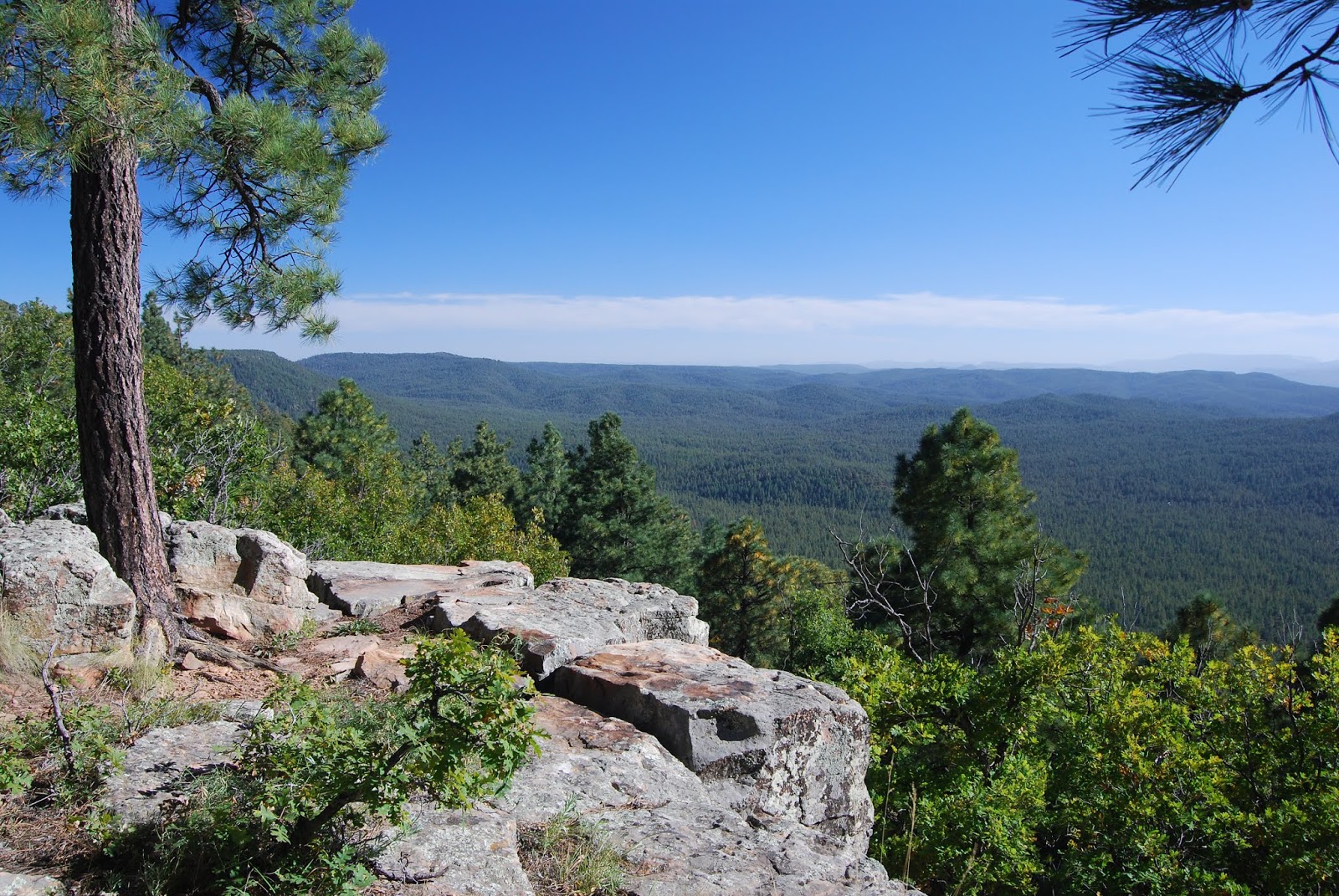
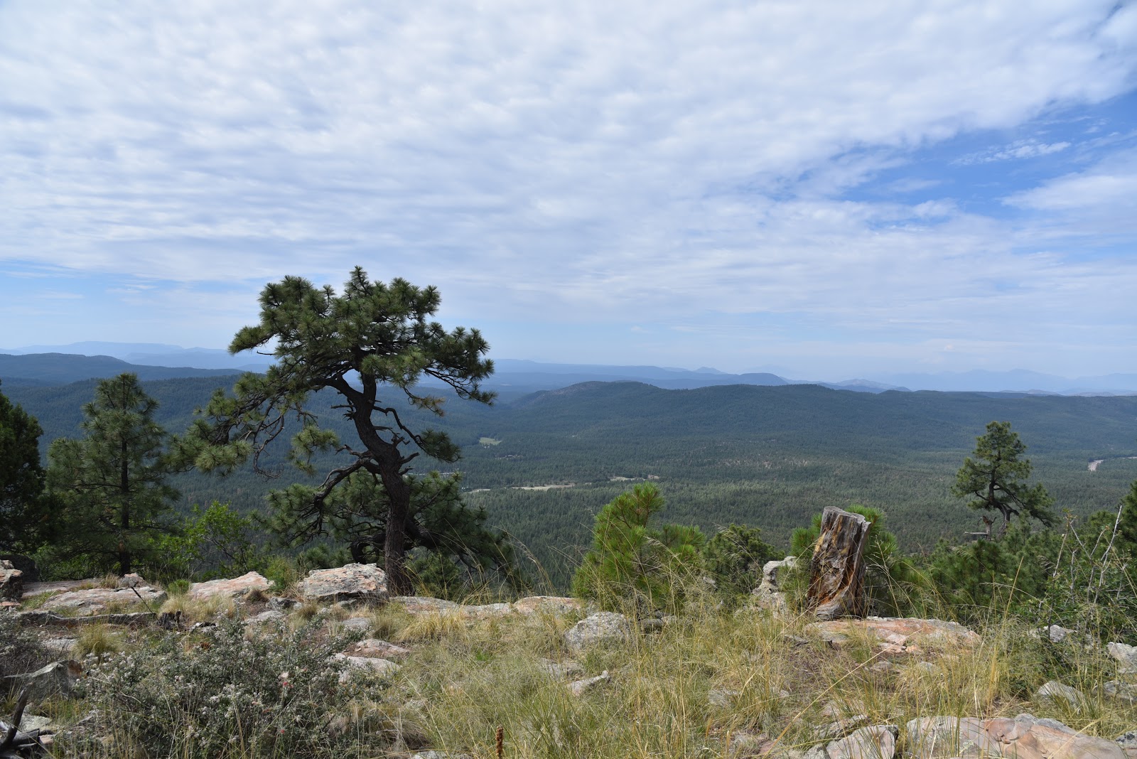
On the way up, glimpses of the Mazatzal Wilderness tease of sweeping vistas to come. With every few feet of elevation gained, the views blossom into ever expanding panoramas of emerald valleys and distant mountains.
Approaching Pine Spring
At the 1-mile point, the trail meets Highline Trail #31 which is also part of the state traversing Arizona Trail Passage #27. With the major climbing done, you can now breath easier and enjoy hiking to the water spots strung out along the route. Red Rock Spring is located a few yards to the left (west) of the junction. It's a beautiful, shaded spot with a concrete trough that usually has water suitable for drinking once its been filtered. From here, hike one mile east (go right at the junction) to Pine Spring. Sheltered among tall pines and whispering maples, this historic site features two antique wooden spring boxes that are no longer effective at trapping the flow. The wayward water runs downhill in lazy rivulets, supporting a ribbon of greenery and a healthy population of Yellow Monkey Flowers growing on a soggy embankment. In a pinch, you could filter some drinking water here, but, don't count on it. The next 
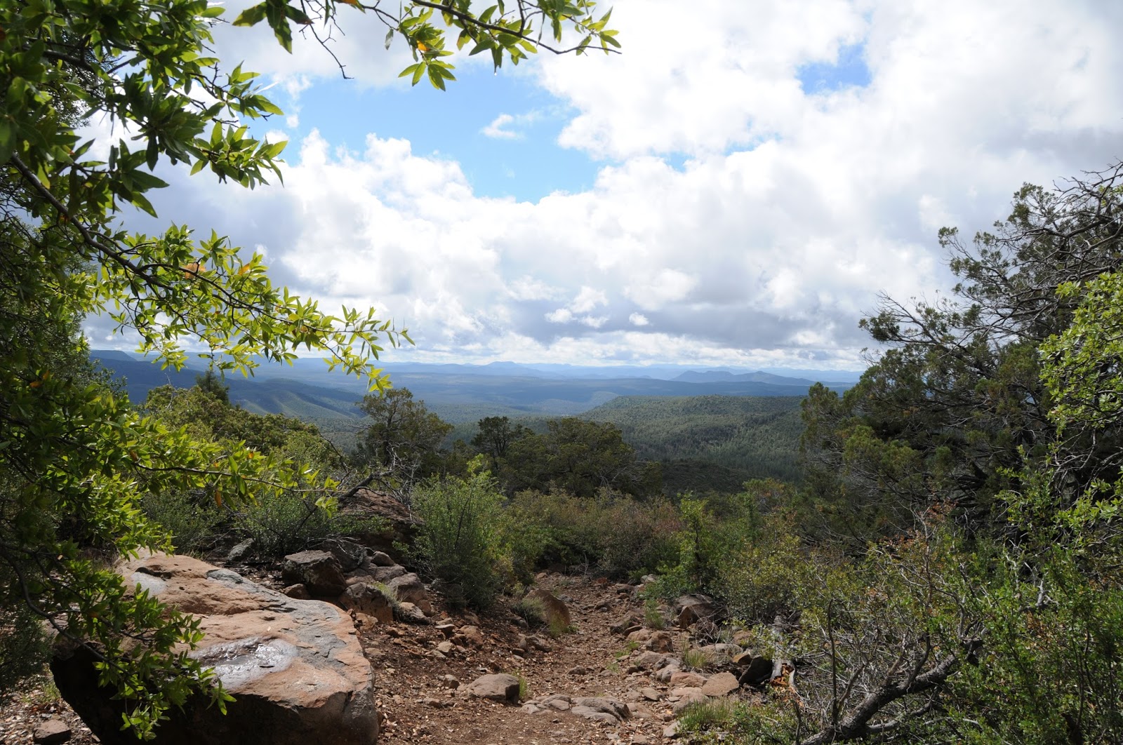
three miles of the route duck in and out of dark forests and sun exposed, yucca-fringed ledges before coming to the cool waters of spring-fed, Webber Creek near the Geronimo Trailhead. If you're up for more, the Highline Trail continues 8 miles east to the 260 Trailhead while the Arizona Trail turns north at Washington Park on its way to the Utah border.
Mountain views all around
LENGTH: 5 miles one way to Geronimo Trailhead
To Red Rock Spring: 1 miles one way
To Pine Spring: 2 miles one way
RATING: moderate
ELEVATION: 5,390' - 6,050'
GETTING THERE:
Red Rock Spring (west) Trailhead:
From the intersection of State Routes 87/260 in Payson, go 12 miles north on SR 87 to milepost 265 (2 miles north of Tonto Natural Bridge State Park) and turn right on Control Road (Forest Road 64). Continue 2.4 miles to the trailhead on the left. This is easy to miss because the trail sign is located about 30 yards up from the road. There’s no parking lot-- just find a spot in the turnouts along the road. Control Road is maintained dirt suitable for passenger cars.
Highline Trail #31
Geronimo (east) Trailhead:
From the Red Rock trailhead, continue another 3.5 miles on Control Road to Forest Road 440 (Webber Creek Road). Go left (north) on FR 440 and continue 2 miles to the Geronimo trailhead on the right. High clearance is recommended on FR 440.
INFO: Payson Ranger District, Tonto National Forest:
Arizona Trail Association:
MORE PHOTOS: