Find A Trail. Start Your Search Here:

Wednesday, March 2, 2022

Latigo-Sidewinder Loop

LATIGO-SIDEWINDER LOOP

View from the Sidewinder Overlook


Immersion into the assorted levels of awesomeness of the Sonoran Desert is as easy as stepping off the pavement and into the Scottsdale McDowell Sonoran Preserve.

Creosote shrubs grow among occotillo stems

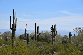
With over 200 miles of non-motorized trails, the northeast Valley preserve is a major draw for hikers, bikers and equestrians of all levels of expertise. 
Chuparosa plants grow from cracks in granite


With winter visitor season in full swing, it’s smart to have a go-to selection of short and easy treks that showcase the amazing beauty and diversity of our Valley trails.

A crested saguaro is a highlight of the hike

Approachable and enlightening, the Latigo-Sidewinder loop offers a quick trip that’s packed with botanical, geological and scenic wonders. 
Tiny desert rock peas thrive in sunny spots

It’s the perfect hike to do with those who may not be regular trekkers or acclimated to desert conditions. 
Scientists aren't sure how crested saguaros form

Kid’s love it, too.
The route passes through a boulder corridor
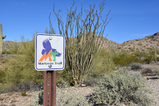
The tour begins at the new Pima-Dynamite trailhead where restrooms, shaded seating areas and interpretive signs add welcoming amenities as well as a sense of anticipation.

Stop and smell the lavender on the Latigo trail

An easy half-mile walk on the wide, sandy Latigo trail enters the preserve’s far west edge, passing under powerlines that curiously mimic look the long, slender stalks of native ocotillo cactus.

A phainopepla bird feeds on mistletoe

Along this introductory leg, a veritable botanical garden of blooming native plants vie for attention.  Look for sulfur-yellow desert marigolds and brittlebush, red chuparosa shrubs, fairy dusters,  delicately fragrant desert lavender and the golden desert rock pea. Fruit bearing thornbush, wolfberry and invasive mistletoe attract birds like cactus wrens, phainopeplas, mockingbirds and doves while rabbits, squirrels and lizards surrey among jojoba bushes and many species of cholla cacti. 
Fairy duster shrubs are common on the hike

At the Sidewinder trail junction, head right and follow the signs to the main botanical event—a magnificent crested saguaro.  A sign near the rare specimen presents theories on how the contorted fan-like crests of these desert curiosities might form. 
Desert hyacinth "blue dicks" have edible roots

Desert marigolds add spots of gold to the hike


Just beyond the  crested saguaro, the trail enters a boulder-lined corridor with an optional short detour to the Sidewinder Overlook where Valley mountain ranges my be viewed from a platform of granite shelves.  Newcomers are often stunned by the variety and profusion of desert plant and animal life and the juxtaposition of a low, arid environment with a ring of mountain peaks that might be snow-capped in winter.  

Doves are easy to spot along the trails

A Northern mockingbird sings from atop a saguaro

From the overlook, follow the signs back to the Latigo trail and swing back to the trailhead for a satisfying 2.7-mile loop.

This swift dive into a family-friendly corner of Scottdale McDowell Sonoran Preserve is one to keep in mind for entertaining visitors or just wallowing in local flora and fauna without a lot of fuss.    

LENGTH: 2.7-mile loop

RATING:  easy-moderate

ELEVATION: 2,339 – 2,450 feet

GETTING THERE:

Pima-Dynamite Trailhead:

28777 N. Pima Road, Scottsdale

There are two access roads near the corner of Pima ad Dynamite Roads and the other is on Pima just north of the traffic signal and one a few yards east on Dynamite. There are restrooms at the trailhead.

HOURS: sunrise to sunset daily

INFO:

Scottsdale McDowell Sonoran Preserve

https://www.scottsdaleaz.gov/preserve


Tuesday, March 1, 2022

Dynamite Trail

DYNAMITE TRAIL

Dynamite Trail passes through a leafy desert wash

San Tan Mountain Regional Park in Queen Creek is a 10,198-acre mountain-bound property that anchors the far southeast reach of the 10 Maricopa County Regional Parks that circle the Valley.  The park’s 9 non-motorized trails plus a short interpretive loop, provide options for trail users of every level of experience. 

Big valley views on the Dynamite Trail saddle

Situated in a hilly expanse bolstered by Goldmine Mountain in the north and the Malpais Hills in the south, the park’s 20+ miles of trails wander among lush desert vegetation, scoured washes and scenic high points with excellent valley vistas. One moderate route to try uses parts of the Littleleaf, Goldmine and San Tan trails to connect with the park’s northwest classic—the Dynamite trail.

The route is part of the 315-mile Maricopa Trail

Fragrant creosote shrubs cluster around the trails

Ocotillos frame mountain views on the Dynamite Trail

All three trails are also part of the 315-mile, Valley circumnavigating Maricopa Trail.
Mountain vistas begin on the Littleleaf Trail

The 2.5-mile path may be accessed by way of connecting routes from either the main park trailhead or the Goldmine trailhead located at the park’s northwest end.  With extra amenities like real restrooms and a visitor center, the main park trailhead is a good place to start.
Mountains close in on the Dynamite Trail

Begin with an easy  0.7-mile walk on the Littleleaf trail. While it gains only 85 feet in elevation, it’s enough to serve up appetizer vistas of distant Tonto National Forest and Mazatzal Wilderness mountain peaks.  This warmup segment is followed by a 0.4-mile hike on the Goldmine trail which undulates through drainages and cholla forests before arriving at the junction with the San Tan Trail where Goldmine begins its strenuous uphill haul.  For this trip, head left on the San Tan trail and continue 0.4-mile to link up with the destination route—the Dynamite trail.  It’s along this segment where the mountainous nature of the park becomes headily apparent.  The Malpais Hills jut abruptly on the near horizon while the green valleys of the Gila River Indian Community peek out to the southwest.

Goldmine Mountain seen from the Littleleaf Trail

The Dynamite trail starts out by tracing the western foothills of Goldmine Mountain ducking through ironwood-cluttered washes, acres of creosote shrubs and many impressive stands of saguaros and cholla cacti.
Junctions are well signed in the park

At 2.4 miles from the trailhead, the route takes on a series of switchbacks that ease the climb to a mountain saddle.  On the breezy divide, a fresh set of views open up over sprawling east Valley suburbs that stretch into the Superstition Mountains and, on clear days, all the way to the New River Mountains to the far north. 
Dynamite Trail descends from the high saddle

Viewing benches placed at scenic overlooks throughout the route, including on the saddle, invite trail users to sit awhile and soak up the beauty.  From the saddle, the trail spirals downhill over long, lazy curves, passing by historic grave sites before reconnecting with the Goldmine trail near the Goldmine trailhead on Wagon Wheel Road.
The route crosses several sandy washes

Switchbacks ease the climb to the Dynamite saddle

Unless you parked a car-shuttle vehicle there, return the way you came. Or, for a more difficult return route, loop it up with the 2.5-mile Goldmine trail for a challenging climb to the park’s highest point and even more outstanding viewing opportunities.

LENGTH: 4.1 miles one-way or 8.2 miles round trip, as described here.

Use the Goldmine trailhead for a car shuttle hike

RATING: moderate

ELEVATION: 1,617 – 1,894 feet

GETTING THERE:

South: San Tan Mountain Regional Park main trailhead:

6533 W. Phillips Road, Queen Creek.

From U.S. 60 in Mesa, take the Ellsworth Road exit 191. Go south on Ellsworth to Hunt Highway and continue east to Thompson Road. Go south on Thompson Road to Phillips Road and follow the signs to the main park entrance. The park has restrooms, water, a visitor center, equestrian staging area and picnic tables.

North: Goldmine trailhead:

From Hunt Highway north of the main park entrance, go 1.2 miles west on Empire Blvd. to Wagon Wheel Road, turn south and follow the road 1.0 mile to the Goldmine trailhead.

If no attendant is on duty, pay the entry fee in cash to the “iron ranger” (metal kiosk with payment envelopes). Follow the Goldmine trail 0.2-mile to connect with the Dynamite trail.

There are portable restrooms at the trailhead but no other amenities.

FEE: $7 daily fee per vehicle or $2 per person walk-in/bike-in fee.

HOURS: the park is open for day use only from 6 a.m. to 8 p.m.

INFO & MAPS:

San Tan Mountain Regional Park

https://www.maricopacountyparks.net/park-locator/san-tan-mountain-regional-park/