


Granite Mountain Hotshots
Memorial State Park, Yarnell
 |
| Journey Trail |
I’m not a fan of writing
trail descriptions in the first person. Hiking trails are not about me. The
staring characters of Arizona trails are the terrain, waterways, scenery,
wildlife and plants. That I happened to hike a particular trail is incidental
and not part of its theme or the influence it will have on other trekkers. When
approaching a trail, I plan for the worst and hope for the best while in
anticipation of foul ups, the mantra “suck it up, buttercup” bounces around in
my skull. Normally, I subdue my voice so my personal biases won’t dilute a
trail’s character or unwittingly seed expectations. Why rob hikers of the joy of discovery? But
occasionally, there’s a trail that’s so steeped in emotion that all I can
muster is a stammering, first person account. The Hotshots and Journey Trails
at the Granite Mountain Hotshots Memorial State Park near Yarnell embody that
spirit.
 |
| Hotshots Trail |
My first impression of this
oddly remote and decidedly vertical destination was one of awe and confusion. As
State Route 89 approaches the site, the imposing Weaver Mountains rise over the
desert in sheer, granite heaps. I wondered how the heck does a trail get up
those hills? The answer came at the trailhead which is just a tiny pull out
along the highway, its fresh-paint and bright new information kiosk bolstered
by neon orange road barriers. Here, a metal staircase hoists hiker up an
insurmountable cliff face to connect with the trail. From this point, the hike
is a whole lot of up with a few short stretches of flat in between. Epic views
of the Date Creek Mountains and dry-wash-riddled valleys appear immediately.
These wildlands give us so much. Fresh air, peace and quiet, natural resources
and recreational opportunities. Peering out over landscape, the random remains
of torched trees remind that the wildlands also take. In June 2013, the Yarnell
Hill Fire blazed through this rugged territory taking the lives of 19 fire
fighters. These brave men are memorialized with plaques placed roughly every
600 feet along the Hotshots Trail. Additional signage placed near benches at
scenic lookouts, gives information about firefighting and the timeline of the
Yarnell Hill Fire. The first memorial plaque shows up after a few hundred feet
of hiking. It’s mounted on a gigantic, pyramid-shaped granite boulder and sets
the stage for an emotional 2.85-mile journey of remembrance. This hit me harder
than I thought it would. I didn’t know any of these men or their families, so
why was a pain in my gut working its way up to my throat?
 |
| Date Creek Mountains |
“I’m not gonna cry. I’m not
gonna cry. Suck it up.”
As I approached each plaque,
I stopped to read the short paragraphs about each man’s life. They were so
young and dedicated to their work and families. It occurred to me that the
nature of their work also made them elite hikers---kindred spirits for those of
us who aspire to trek for miles in horrible conditions packing 50 pounds of
gear and still have enough energy and courage to risk life and limb to protect
others.
“Heart be still. Ain’t gonna
happen. Suck it up.”
 |
| Saddle overlooking the town of Yarnell |
Just beyond the final
plaque, the trail makes a long traverse on a ridge overlooking the fatality
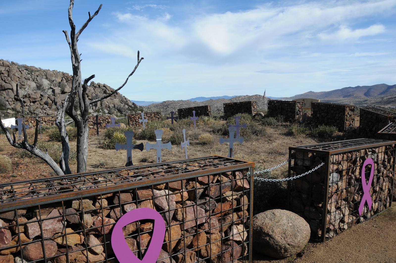
site. Four hundred feet below, a Stonehenge-like circle of 19 gabions surrounds
the place where the men perished. At the
trail’s high point, an observation deck marks the beginning of the Journey
Trail that traces the hotshots final trek. Here, I met a group of people
wearing t-shirts and hats emblazoned with various fire department logos. They
came from Phoenix, Prescott, Flagstaff, California and Canada in sort of a
pilgrimage of brotherhood. There’s a sign at the deck with color photos of the
19 and a summary of the fire’s progression. When viewed from just the right
angle, the portraits align with the fatality site below.
 |
| Fatality Site |
“I’m not gonna cry.”
Decision time. Should I go down
the 0.75-mile Journey Trail to visit the final memorials? To further mess me
up, right at this juncture, a flock of ravens appeared on the air currents
above, their vocalizations morphing from “Caw, Caw” into “Go, Go”. A psychic in
Sedona once told me that the raven is my animal totem, so I went. The sensation was a maniacal elixir of exhilaration
and numbness. I didn’t know quite what to feel. Was this a taking sort of voyeurism
or a genuine giving of respect? It’s hard to discern when distracted by conflicting
moods egged on by astonishing beauty and utter disaster.
The fatality site sits at
the mouth of a yawning canyon a heartbreaking half-mile from a ranch. The ugliness
of the fire has mostly disintegrated and fresh sprouts are emerging from the
bases of resilient shrubs that were here, then gone and here again.
 |
| Fatality Site |
At the east end of the
memorial circle, somebody left a scorched Granite Mountain Hotshots t-shirt.
That’s where I lost it. Heaving sobs for
people I don’t know in a place I had never been, I guess this trail was a
little bit about me after all. And it's about you, too. We live, we love, we hike, we win,
we lose and it all ends up in a big friggin’ circle--kind of like the one that rolled
out before me at the base of Yarnell Hill.
 |
| The T-Shirt |
LENGTH: 7.2 miles roundtrip
RATING: moderate
ELEVATION: 4,318’ – 5,061’
GETTING THERE:
From Phoenix, take
Interstate 17 north to State Route 74 (Carefree Highway). Head 30 miles west
toward Wickenburg and turn right (north) on US 60. Continue on US 60 to the
traffic circle at the Hassayampa River bridge, veer left and go north on State Route
93 to State Route 89 (White Spar Highway). Follow SR 89 toward Yarnell, go left
at the split, head up the winding mountain road and turn left at the sign for
the park. Roads are 100% paved. There
are 13 parking spaces and temporary restrooms at the trailhead.
INFO & MAP: