Find A Trail. Start Your Search Here:

Showing posts with label Bartlett Lake. Show all posts

Sunday, December 30, 2018

Indian Spring Wash

Indian Spring Wash
Indian Butte framed by last season's yucca sprouts.
By way of Forest Road 532, it’s a six mile hike from Bartlett Dam Road to the Verde River. The road is neither the most efficient nor the easiest way to get there, but it offers a pleasant backcountry trek over varied terrain with outstanding views.  The road is part of a cluster of recently restored shared-use routes in the hills between Horseshoe Reservoir and Bartlett Lake northeast of the Valley. 
The first mile is a sandy slog in Indian Spring Wash.
Overlooking the Verde River Valley
Open to ATVs, bikes, horses and hikers, the roads wind through a part of the Tonto National Forest Cave Creek Ranger District.   
Desert honeysuckle bloom in the wash.
A map at the trailhead gives an overview of the system, which at first glance, can be intimidating. However, Forest Road 532 is well-signed and easy to follow. The hike begins in the sandy spillway of Indian Wash. Deeply rutted and softened by motorized traffic and periodic flooding, the first mile is tantamount to walking on a beach. The washy walk dodges among giant granite pillars, sandbars and a 
robust showing of desert hackberry, mesquites, turpentine bushes, desert honeysuckle and blooming wildflowers. At the 1.9 mile point, the road moves out of the wash and into the hills as it head up to the saddle between Indian Butte (3745 feet) to the east and Saint Clair Peak (4230 feet) to the west. The first rise provides amazing vistas of landscape of rolling foothills trees, cholla, yucca and shrubs, but the big story here is the mountain vistas. Silhouettes of the Four Peaks, Sierra Ancha and McDowell Mountains form a seamless, peak-centric horizon.  The road tops out where Forest Road 1104 head off toward St. Clair Peak and FR 532 begins its 1500-foot dive down to the river. Take a moment here to scope out wall of wilderness peaks backing the Verde River Basin ahead. It’s a long way down (and it feels even longer on the way out) but the wide road mitigates the struggle with passes by rugged cliffs, scenic overlooks and reed-addled riparian areas down in the wash. 
Just beyond the 5-mile point, heavily-used Forest Road 42 bisects the route signaling the final approach to the river. The road ends roughly halfway between the two lakes near a primitive camping area called Devil’s Hole. If you didn’t pack for an overnighter or arrange to have somebody with an ATV pick you up, enjoy the sights before trudging back the way you came.
Point where the route leaves the wash.
Saint Clair Peak
McDowell Mountains on the horizon.
Forest Road 532 ends at the Verde River
Trailhead map shows the system of shared-use roads.
LENGTH:
To the river: 5.8 miles one-way
To the highpoint: 2.4 miles one-way
RATING:  moderate-difficult
ELEVATION:
Trailhead: 2725 feet
Highpoint: 3303 feet
River: 1800 feet
GETTING THERE:
From the Pima Road/Cave Creek Road intersection in Carefree, go 4.1 miles north on Cave Creek Road to Bartlett Dam Road. Turn right and continue 9 miles to the trailhead on the left where there’s a gate and map kiosk. There’s plenty of parking along the road.


Monday, January 23, 2017

PALO VERDE TRAIL

PALO VERDE TRAIL

Tonto National Forest, Bartlett Reservoir
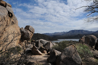
Granite boulders above Bartlett Lake
From the drive in to the trailhead to its turnaround point, this hike is packed with stunning scenery. Hedged among rough cut cliffs and desert highlands of the Verde River watershed, Bartlett Reservoir fills 12 miles of the canyon bound channel with crystalline waters teeming with bass, catfish and bluegills. Although the year-round recreation site which is located roughly 50 miles north of Phoenix is famous mostly for its boating, fishing, shaded picnic areas and camping opportunities, the Palo Verde Trail offers hikers a surprisingly challenging route with terrific mountain and water views. The trail meanders among the foothills and washes on the lake’s western banks. This is not a hike to try during or immediately after storms because rain rumbling off the foothills turns washes and gullies into raging rivers of debris.
Chollas frame Tonto National Forest mountain vistas
Don’t be fooled by the hike’s minimal amount of elevation change---the trail is a deceptively convoluted series of twists, steep climbs and slippery descents on a base of crumbling granite and sand. Overall, you will have accumulated 900+ feet of elevation gain over the 9.4-mile, out-and-back trek.  The trail wastes no time getting you up into the hills above Rattlesnake Cove for breathtaking vistas of the distant peaks of the Mazatzal Wilderness and fire tower-capped Mount Ord. Across the water, the hulking profiles of Maverick and SB Mountain in Tonto National Forest bolster the reservoir’s 33 miles of shoreline casting shadows on peninsulas and islands that morph in size with water levels. 
Rattlesnake Cove
In springtime, these hills are ablaze in wildflower glory. Look for desert lavender, chuparosa, brittlebush, Mexican gold poppies, filaree, lupines and blooming cholla and saguaro cacti.
Beyond the marina at near the 3-mile point, the trail splits. The path to the left is a spur that shaves a mile off the route. To the right, the main trail makes a hairpin loop among deep washes, quartz mounds and areas of washouts that make the route somewhat difficult to follow. Strategically-placed rock barriers and cairns mark the way. Soon, you’ll reach the beachy inlet of SB Cove. Strewn with driftwood, this cozy notch in the landscape is a favorite stomping ground for blue heron and seasonal shorebirds. The route terminates a short walk from the SB Cove Recreation Site. If you didn’t park a shuttle vehicle there, return the way you came.
Foothills of the Verde River watershed
LENGTH: 4.7 miles one way or 3.7 with shortcut
RATING: moderate
ELEVATION: 1798’ – 1882’
GETTING THERE:
Desert lavender can bloom any time of year
From Loop 101 in Scottsdale, take the Pima/Princess Drive exit 36 and go 13 miles north on Pima and turn right on Cave Creek Road.  Continue 4.1 miles to Bartlett Dam Road, turn right and go 12.6 miles to North Shore Road (Forest Road 459). Turn left continue 0.6 mile to the turn off Rattlesnake Cove Recreation Site (Forest Road 459A). Park at the last restroom at the south end of the parking loop. Walk down the stairs behind the restrooms and head right toward the trailhead sign.
FEE: A Tonto Pass is required to park.  $6 daily fee per vehicle.
INFO: Tonto National Forest

Friday, September 19, 2008

JOJOBA TRAIL

JOJOBA TRAIL #511 Arrive early enough in the morning and you’ll be greeted by turkey vultures roosting on escarpments above the driftwood-littered beaches of Bartlett Lake. Years of drought have taken a toll on the lake. Low water levels have exposed colorful stratified layers of earth around the man-made reservoir. The Saturn-esque bands read like tree rings, providing a petrified snapshot of the lake’s ever-changing water levels. Jojoba Trail climbs along the same cliffs favored by the vultures for dramatic views of the lake and the surrounding arid hillsides. Framed with healthy stands of ocotillo, desert lavender and, of course, jojoba shrubs, the trail meanders above the stark canyon lake. As the route approaches the turnaround point near the marina, a promontory juts out above what used to be an inlet teeming with fish. Today, the cove is bone-dry and serves as a reminder of the fickle nature of water in the desert. LENGTH: 2.6 miles round-trip RATING: Easy ELEVATION GAIN: 60 feet GETTING THERE: From Scottsdale, go north on Pima Road to Cave Creek Road. Turn right (east) on Cave Creek Road and continue 4 miles to Bartlett Dam Road and turn right. Go 13 miles and turn left at the sign for Rattlesnake Cove Recreation Area (Forest Road 459). Follow FR-459 to Forest Road 459A, turn right and continue to the parking area. A Tonto Pass ($6 daily fee per vehicle) is required. There are restrooms and water at the trailhead.