


Fall Color Over Jerome
Looking for an under-the-radar alternative to Sedona’s West
Fork of Oak Creek and Flagstaff’s Inner Basin for fall color hiking? Try a few of the trails that explore the lofty
summits of Mingus and Woodchute Mountain. The mountain top recreation destinations
that hover over the arty community of Jerome are popular year-round for hiking,
camping and day-trip picnicking. Located between Prescott and Jerome the airy
trails wander through woodlands and meadows with fantastic viewpoints at precipitous
edges. In autumn, forests of Gamble oaks and Big-tooth maples that drench the
slopes in warm shades of crimson and gold adding spectacular color to an
already amazing set of trails. Here are three to try. |
| Find colorful oaks on these mountain trails |
WOODCHUTE MOUNTAIN
TRAIL
Woodchute Wilderness
Area
 |
| Golden oaks on Woodchute Mountain |
Cooler temperatures and shorter days of autumn work together
to paint the oak trees on Woodchute Mountain in a palette orange and gold. The
mountain is really more of a long ridgeline with Prescott Valley on one side
and grand views of the red cliffs of Sedona and the peaks of Flagstaff on the
other. Easy-to-follow, trail No. 102 meanders 3.7 miles up the mountain on
a moderate slope that swings from east
to west showcasing vistas of much of northern Arizona.
 |
| View of Prescott Valley from Woodchute Mountain |
Beginning at 7,000 feet, the hike culminates with an easy
stroll across a breezy high prairie that dead-ends at the 7,600-foot east face
of the mountain. Here, blood-red maples and honey-colored scrub oaks frame
views of Jerome and the Verde Valley.
 |
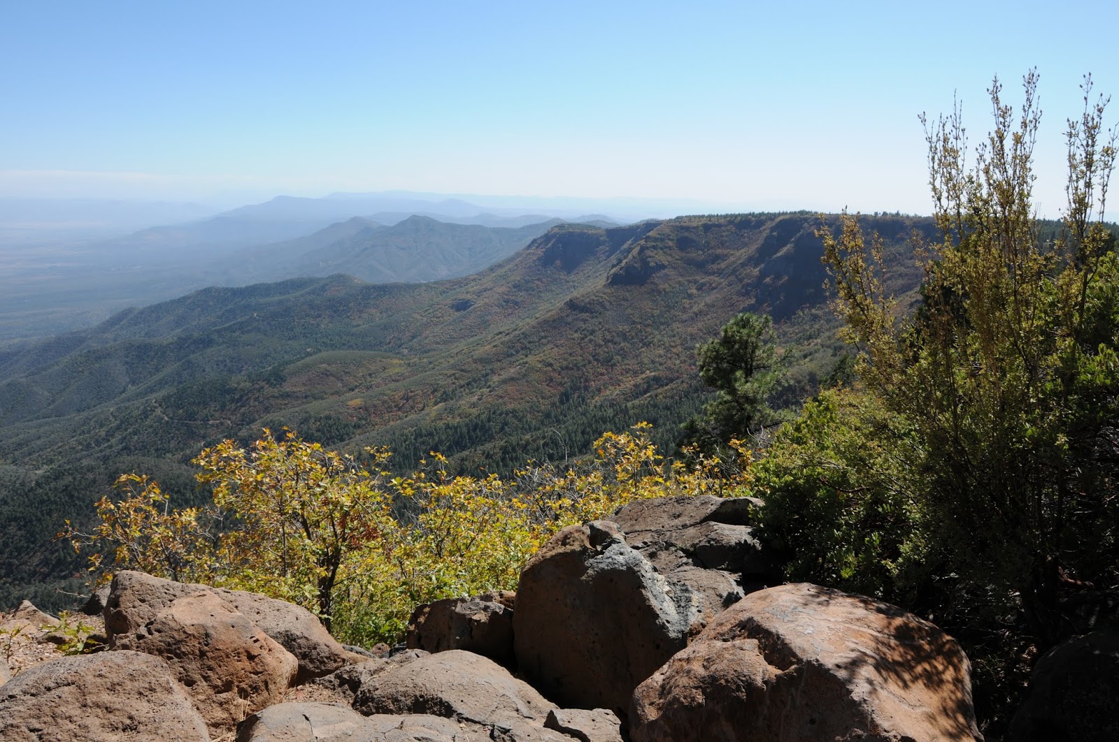
| Epic vistas on Woodchute Mountain |
GETTING THERE:
From Jerome, go 7 miles southwest on State Route 89A to the turn off for Potato
Patch Campground. Turn right and continue .3 mile to the signed road for the
Woodchute trailhead on the left and follow it to a parking loop with restrooms.
Those without a high clearance vehicle should park here. To find the trailhead,
head right (east) and hike or drive (high clearance needed) up Forest Road 106
(also signed as FR 102/106) for a half-mile to the wilderness sign and trail
register. If you opt to hike the road, add 1 mile to the trip length above.
VIEW POINT TRAIL
Prescott National
Forest
 |
| An oak archway on the View Point Trail |
A traipse through an archway of toasty golden oaks sets the
stage for the hallmark mountain vistas and brilliant foliage of the View Point
Trail No. 106. Beyond this “grand entrance” the slender path begins its
gradual, 2-mile descent along the east face of Mingus Mountain weaving through
a mixed bag of terrain including exposed juniper-agave high desert and pine-oak
forests fringed with Big-tooth maples.
 |
| See-forever views on the View Point Trail |
 |
| Gambel oaks frame color views on the View Point Trail |
GETTING THERE:
From Jerome, go 7 miles southwest on State Route 89A to Mingus Mountain Road
(Forest Road 104). Turn left and continue on FR 104 for 2.4 miles to where it
ends at a “T” intersection in the campground. Take an immediate left and park
in the circular turnout near the “106” trail sign.
NORTH MINGUS TRAIL
Prescott National
Forest
 |
| Pine-oak woodlands dominate the scene on N. Mingus Trail |
An eclectic mix of scenery and forests are the highlights of
the North Mingus Trail No.105. Although there are two trailheads for this
route, most hikers choose to start at the top of Mingus Mountain and hike
downhill. That’s because the route is easier to follow when hiked in this
direction. Right from the start, this popular trail will “wow” you with
magnificent views from 7,800 feet atop a pine-shaded hang glider launch pad.
 |
| Summit of Mingus Mountain--N. Mingus Trail |
Here, the rugged Verde Valley rolls out 1,600 feet below.
The 8.5-mile roundtrip hike begins with a pleasant stroll across the mountain
summit under a canopy of warm gold Gambel oaks huddling beneath enormous conifers.
After this short “warm up” section, the trail dips downhill along the north
face through colorful corridors of Big-tooth maples, boxelders and velvet ash.
 |
| A stony passage on N. Mingus Trail |
GETTING THERE: Mingus
Mountain trailhead: From Jerome, go 7 miles southwest on Highway 89A to
Mingus Mountain Road (Forest Road 104). Turn left and continue on FR 104 for 2.4
miles to where it ends at a “T” intersection in the campground. Turn left here
and go uphill to the trailhead near the hang glider launch pad. Mescal Spring trailhead: From Jerome,
go 4 miles southwest on Highway 89A. Just before sign for Prescott National
Forest, between mileposts 339 and 338, turn left onto an unmarked dirt road
(Forest Road 338). FR 338 is a very rough 4x4 road so those without appropriate
vehicles should park in the turnouts along the highway. Continue down FR 338
for a half-mile to the cement tank that marks Mescal Spring. From here, veer
right (southwest) and go uphill. Bear left at all unmarked junctions until you
reach the signed turn off for trail No. 105 on the right. This route adds one
mile to the hike description above.
-->