Find A Trail. Start Your Search Here:

Sunday, December 25, 2016

HACKBERRY SPRING

HACKBERRY SPRING
Tonto National Forest/Superstition Wilderness
Hackberry Spring Dec. 25, 2016
Intrepid hikers with a good pair of boots and reasonable balance will have no trouble navigating the maze of horse trails that lead to Hackberry Spring in the Superstition Wilderness Area. The hike begins on an old dirt road that leads to a collection of decaying corrals and dilapidated buildings that surround the spidery legs of a windmill. Over the years, the windmill’s blades gradually rusted, fell to the ground and eventually disappeared. Please take only pictures and leave only footprints. From this abandoned ranch site, look for a slim dirt path to the left of the windmill and follow it to the slickrock corridor of First Water Creek.
Slickrock section through First Water Creek
Veer left and enter a stony corridor that flanks the wilderness boundary. Although the route is heavily travelled, directional fortitude and minor scrambling is necessary. Depending on rainfall, the creek can be churning, trickling or reduced to residual pothole pools. Regardless of its condition, expect to hop the creek about a dozen times and wet feet are a real possibility. It’s advisable to avoid the area during and immediately following heavy storms for safety and to avoid eroding the trails.

The route soon enters a water-scoured gorge weaving among boulders, tiny stands of trees, and reeds full of vociferous, cardinals and canyon wrens. Evidence of the area’s volcanic origins as well as the landscape-shaping effects of running water is showcased in soaring canyon walls, shallow caves chiseled out of lava rock and hundreds of mini pools scoured from solid rock. The spring itself features a rusty pipe poking out of a cliff face that funnels water into a quiet pool surrounded by Fremont cottonwoods, Goodding willows and, of course, hackberry shrubs. Return the way you came or consult forest service maps for alternate routes.

LENGTH: 3 miles round-trip
RATING: moderate, some route-finding skills are required.
ELEVATION: 1,900 – 2,450 feet
GETTING THERE: From Phoenix, take US 60 east to the Idaho Road/State Route 88 exit 196. At the bottom of the off ramp, go left, follow Idaho Road to SR 88, turn right and continue to just past the Lost Dutchman State Park entrance (between mileposts 201 and 202) and turn right onto First Water Road (Forest Road 78). Follow FR78 for just over 2 miles to the horse parking lot (NOT the First Water trailhead) on the left and park there.


Thursday, December 22, 2016

CAROL BARTOL PRESERVE at SAGUARO HILL

ARTISTIC MUSINGS on SAGUARO HILL

Cave Creek
Art imitating life.
In his essay The Decay of Lying, Oscar Wilde stated: “Life imitates art far more than art imitates Life.” This concept has been fodder for arguments among philosophers and pundits since ancient times. Throughout history, notable minds have contributed to the fray.
 “Art is imitation and that’s bad.”  Plato
 “Art completes what nature cannot bring to finish. The artist gives us knowledge of nature's unrealized ends.” Aristotle
“Art is what you can get away with.” Andy Warhol

Genuine and imposter saguaros mingle on the hill.
The serene memorial gardens and trail at the Carol Bartol Preserve at Saguaro Hill is an excellent place to ruminate on the muddling of life with art and there’s a perfect subject waiting at the gateway--fake saguaros. At the top of the preserve’s entry staircase, visitors are greeted by an array of enormous sculptures imitating Carnegiea gigantean. At first glance, their too perfect, unblemished façade and pure symmetry might make you think these are superb genuine specimens, but the not-quite-right-green coloring and suspicious seams reveal the ruse. Look a little closer and high voltage signs tacked around the back eliminate any lingering doubt.
The cleaver shells disguise cellphone towers. While the structures’ purpose and placement are cause for pause, consider of the big picture before condemning. Case in point, on a recent visit, I observed a couple making comments about how awful the towers look while snapping photos of them with their cell phones.  So, essentially we have an ersatz life form concealing the means to make visual facsimiles that will undoubtedly end up on a social media forum that apes actual living.  Ironic, methinks.
Moving on, there’s more to the preserve than the gallery of paradox. If the 6-acre parcel in Cave Creek isn’t the tiniest hiking destination in Arizona, then it’s certainly a contender. Situated on a mini ridge behind the town library, the site was the first property purchased by the Desert Foothills Land Trust, a nonprofit, all-volunteer conservation organization which protects over 680 acres on 23 preserves in the Sonoran Desert Foothills.  The teeny hillside features gardens with placards identifying plants, seating areas and a short hiking trail with interpretive displays about the life cycle and survival strategies of saguaros. Want to know how to tell the difference between a barrel cactus and a saguaro? There’s a sign for that. In addition to its educational features and adjacent media center, the trail showcases views of Black Mountain and the wild ranges of Tonto National Forest. After exploring, let the aroma of mesquite drifting from local eateries lure you to a cozy table to discuss the intersection of art and nature over drinks, grub and a smart phone.
Black Mountain seen from Saguaro Hill Preserve
LENGTH: 0.5 mile
RATING: easy
ELEVATION: 2240’ – 2280’
HOURS: open every day from dawn to dusk
GETTING THERE:
From Cave Creek Road, turn north on School House Road and continue 0.1 mile to the Desert Foothills library parking lot.
INFO: Desert Foothills Land Trust

Monday, December 19, 2016

DAVID YETMAN TRAIL

DAVID YETMAN TRAIL

Tucson Mountain Park
View of the Tucson Mountain on David Yetman Trail
How exactly do people get a trail named for them? Well, there’s probably no one formula, but it certainly helps if you’ve made considerable contributions in the fields of conservation, outdoor recreational planning or the sweat and grind of construction and fund raising for Arizona trails. Or, maybe you become a celebrity scientist who stokes curiosity in desert biomes. David Yetman Ph.D., is that kind of guy. As a scientist, author, photographer and host of The Desert Speaks series on PBS, he’s been educating the masses for decades.  
The "stone house" is made from local rocks.
The eponymous trail is a roundup of all things desert-y offering a rich trip among Sonoran desert plants, animals and homesteading history wrapped up in the ragged peaks and jumbled washes of the Tucson Mountains.  One of the most popular attractions along the trail is the Bowen Homestead which is also known as the “stone house”. The still-standing walls and foundations of the 1930s-era ranch house can be found 1.1 miles from the Camino de Oeste trailhead. Built of native stone that mingles quietly with its surroundings, the structure appears more grown than built.
The trail is rich in desert plants and animals.
Large picture windows that lost their glass years ago, frame sharp-edged escarpments and softly rounded, saguaro-dusted slopes while the footprints of living areas hint at a life far removed from 21st-century excess. An interpretive sign at the site describes the homestead floorplan and gives some background about the Bowen family and their impact on the surrounding territory.
Bowen Homestead
The 5.9-mile one way hike is the longest route within Tucson Mountain Park’s 62-mile trail system. Because it’s anchored by two trailheads and linked to several other trails, it’s easy to customize a long out-and-back or shorter loop trips.
Mesquite trees flourish near washes that flank the trail.
LENGTH: 5.9 miles one-way
RATING: easy
ELEVATION: 2600’ – 3000’
GETTING THERE:
Camino de Oeste Trailhead:
From Interstate 10 in Tucson, take the Speedway Blvd. exit 257. Go 4.5 miles west on Speedway, veer left at the Speedway/ Gates Pass Road fork then make an immediate left onto Camino de Oeste. Continue 0.6-mile along a narrow, dirt road that’s passable by sedan to the trailhead. Roads are 100% paved.
David Yetman West Trailhead:
From Interstate 10 in Tucson, take the Speedway Blvd. exit 257. Follow Speedway/Gates Pass Road roughly 9 miles (mind the narrow, mountain curves) to the trailhead/scenic lookout on the left.
INFO:
Tucson Mountain Park
About David Yetman:
Arizona Public Media (PBS)

Monday, December 12, 2016

BLACK CANYON TRAIL: Gloriana Segment

BLACK CANYON TRAIL: Gloriana Segment
Near Bumble Bee
View of Bradshaw Mountains from BCT
Sandwiched between the spot where Interstate 17 splits to begin its climb up to the mesas and gorges of Agua Fria National Monument and a gaping valley below the Bradshaw Mountains, the Gloriana Segment of the Black Canyon Trail is the middle road between a freeway and  dusty dirt double tracks. The 80-mile route flows from Carefree Highway in Phoenix to just outside of Prescott following centuries-old Native American trails, defunct livestock paths, dirt roads and sections of new construction.
A battered saguaro stands above Maggie Mine Road
The trail is divided into segments with trailheads located along its entire length. The 3.4-mile-long Gloriana Segment is smack dab in the middle and wanders along slopes above the scoured courses of Sycamore, Poison, Arrastre and Rock Creeks.  Geology buffs will find a plenty to explore. Within a few hundred feet of the trailhead, the path bumps into an outcropping of metamorphic rock tilted vertical and resembling fossilized Stegosaurus fins weathering from the earth. A couple of hairpin turns through a gully of giant saguaros and a short walk through a Palo Verde forest deposits hikers on a breezy edge splattered with chunks of milky white quartz overlooking Maggie Mine Road.
"Stegosaurus" rock slabs
Take a moment to spy the various mine prospects that dot the hillsides. Continuing south, the trail wanders through sunny rangeland
accompanied by morphing mountain vistas in what the Black Canyon Trail Coalition calls “Arizona’s Outback”.  The segment can be tackled as an out-and-back day hike, multi-day backpack or a one-way car shuttle using maps available on the coalition’s website.
Juvenile saguaros on the Gloriana Segment of BCT
LENGTH: 6.8 miles out-and-back
RATING: moderate
ELEVATION: 2520’ – 2720’
GETTING THERE: Gloriana Trailhead.
From Phoenix, go north on Interstate 17 to the Bumble Bee/ Crown King exit 248. Follow Bumble Bee Road 1.1 miles to the trailhead on the left. There are no facilities. The hike begins at the south side of the lot near the big sign. Roads are 100% paved. (The sign across the road marks the start of the Bumble Bee Segment.)


Monday, December 5, 2016

DOUGLAS SPRING to BRIDAL WREATH FALLS

DOUGLAS SPRING to BRIDAL WREATH FALLS
Saguaro National Park, Rincon Mountain District
Bridal Wreath Falls
Sometimes, timing is everything.  This is particularly true in the desert where spectacular waterfalls appear like raging liquid phantoms after periods of rain, only to dissolve into trickles and knat-loving muddy drop pools within days.  One of the most accessible transient water shows happens in Saguaro National Park East.  Almost anybody with a pair of decent hiking shoes, a few liters of drinking water and a spare afternoon can marvel at the wonder of an ephemeral desert water chute by way of the Douglas Spring Trail to Bridal Wreath Falls.  Because it's so easy to access, the trailhead is a busy place, especially on weekends.  A shaded kiosk marks the trail gateway into a sunny land of cactus and scrub backed with views of Tucson’s Rincon and Santa Catalina Mountains, which tower to over 8,000 feet. 
Rincon Mountain views on Douglas Spring Trail
The route is tantamount to a 2.5-mile staircase. It’s a constant and sometime steep climb through a landscape that morphs from classic desert into a massive grassland with the feel of an African savannah.  Although there are no wildebeasts or giraffes roaming these plains, it’s prime habitat for mountain lions and area trails are sometimes closed when their activity is high.  In addition to the big cats, javalina, rabbits, and deer share the wilds with gila monsters, raptors and desert tortoises.  The turn off for the short hike to the falls shows up at the 2.3-mile point. Here, surrounded by miles of shadeless, mesquite-dotted prairie, the only clue that a waterfall is nearby is the park service sign pointing the way.  A mild descent leads to a grotto of polished stone where a moderate boulder scramble is required to get to the 50-foot cascade plunging over bare rock like a wind blown ribbon. Rainfall and snow melt dictate whether the falls will be  barely a trickle or a raging white water deluge on any particular day.
Bridal Wreath Falls grotto

View of Tucson from Douglas Spring Trail
LENGTH:  5.2 miles roundtrip
RATING: moderate
ELEVATION: 2745' - 3827'
DOGS: canine hikers are not allowed on Saguaro NP trails.
FACILITIES: none
FEE: no fee at this trailhead
GETTING THERE:
From Phoenix, travel south on Interstate 10 to Tucson.  Take exit 257 at Speedway Blvd and head east (go left).  Follow Speedway Blvd. 17.5 miles to where it dead-ends at the Douglas Spring Trailhead.  Roads are paved all the way.
INFO & MAP: Saguaro National Park

Monday, November 28, 2016

RIDGEBACK OVERLOOK-APACHE VISTA CIRCUIT

RIDGEBACK OVERLOOK-APACHE VISTA CIRCUIT
Phoenix Sonoran Preserve
Ridgeback Trail
Hikers approach the Ridgeback Overlook 
There's no better time than around the holidays to take advantage of the head-clearing benefits of hiking. When overwhelmed by travel plans, entertaining guests, shopping, decorating and hyper-excited kids, sometimes you just need to break away and breath on a peaceful mountain top. You don't have to drive far, load down on heavy duty gear or spend an entire day in the wilderness to get to such a place. In fact, if all you have is a few hours to spare, you can still knock off a double header high point trek in the Phoenix Sonoran Preserve. Beginning at the Apache Wash Trailhead, follow Sidewinder Trail 0.86 mile to the Apache Vista turnoff. This 0.51 mile spur trail circles over two minor peaks above sprawling desert arroyos where on most mornings, commercial hot air balloons float overhead.
Apache Vista Trail
Enjoy the show then descend and continue 0.3 mile on Sidewinder then turn left onto Apache Wash Trail, hike 0.4 mile an turn right on Ocotillo. From here, follow the signs to Ridgeback Overlook for a second short loop on a desert mountain peak. If you're satisfied with just this double peak circuit, hike back down to Ocotillo Trail and hoof it back to the trailhead. Otherwise, download the preserve map and make a day of it on the more than 35 miles of trails that criss-cross the preserve's northern sector.
Ridgeback Overlook Trail
LENGTH: 5.1 miles round trip
RATING: moderate
ELEVATION: 1720' - 2002'
GETTING THERE:
Apache Wash Trailhead, 1600 E. Sonoran Desert Dr., Phoenix.
From Loop 101 in north Phoenix, take Cave Creek Road exit 28 and go 4.5 miles north to Sonoran Desert Drive. Turn left (west) and continue 3.5 miles to the trailhead on the right. The preserve is open daily from sunrise to sunset. There are restrooms but no water at the trailhead.
INFO & MAP:

Monday, November 21, 2016

HUMBOLDT MOUNTAIN

HUMBOLDT  MOUNTAIN
Tonto National Forest
Looking east over Horseshoe Lake
Sometimes I just feel like a brainless hike up a hill with no route finding, treacherous terrain or precarious precipices. Just. Up.  Thankfully, Humboldt Mountain meets this criteria and it's not too far from downtown Phoenix.  You've probably seen this hill and wondered about it ---there's a huge, white “golf ball” (as it’s commonly called) on the summit that’s visible from the back roads north of Cave Creek and Carefree. The white ball, which is an FAA radar station used for air traffic control, shares the summit with a fire tower and a hardware jungle of tech equipment. The hike involves walking up a narrow road of crumbling asphalt via a series of gentle switchbacks and a combination of flat and fairly steep segments. 
Summit views
The 2005 Cave Creek Complex Fire took a toll on the area's vegetation, but recovery is underway and desert shrubs are popping up everywhere. With every few feet of elevation gain, the views get bigger and better.  Much of the lower road winds through cactus-studded grasslands with Cave Creek Mountains, Pinnacle Peak and New River Mesa on the horizon. Higher up, the road winds around to the eastern slope of the mountain where there the sprawling Verde River Valley and Horseshoe Lake come into view. Just below the summit, the one and only hairpin turn in the road kisses the edge of a scenic saddle. Here, sycamore-and-cottonwood cluttered drainages appear as  twisted meanders nearly 2,000 feet below. From this saddle, the final uphill slog to the summit rewards with more excellent views and the revelation that “golf ball” is hardly an accurate description of the FAA tower. It is most indubitably, a
soccer ball.
Final switchback to the top
LENGTH: 7.8 miles roundtrip
RATING: moderate
ELEVATION: 3,570' – 5,204'
BEST SEASON: October – April
GETTING THERE:
Stunning mountain views all around
From Loop 101 in North Scottsdale, take the Pima/Princess Road exit and go 13 miles north on Pima Road to Cave Creek Road.  Turn right (east) and continue on Cave Creek Road (a.k.a. FR 24, Seven Springs Road) to FR 562 (Humboldt Mountain road) located between MCDOT mile markers 9 and 10.  The turnoff is easy to miss—it’s on the right, paved and there’s a “562” sign about 100 feet up the road. If you get to Seven Springs Recreation Area, you have gone roughly 2 miles too far. Park in the turnouts along FR24 and FR562 and hike up FR562 to the summit.

INFO: Cave Creek Ranger District, Tonto National Forest, (480) 595-3300


Saturday, November 19, 2016

WHO DAT?

WHAT'S THAT PATCH MEAN?

Maybe you've noticed hikers sporting colorful Arizona Hiking Group patches and wondered what they represent. Since they became available in September, several hundred trekkers have attached patches and stickers to their gear in hopes of running into other group members while out on the trails.
Members on a group hike in McDowell Sonoran Preserve
Arizona Hiking Group is a virtual meeting place, photo-sharing site and educational resource on Facebook. Established in September 2012, the group has grown steadily to over 7000 members. Group admins seek to foster a friendly, nonsense-free zone where hikers of all levels and backgrounds feel welcome in sharing their experiences and asking for advise. Haters, trolls and off-message interlopers will feel the swift swing of the "ban hammer" because the group values on-topic dialogue. Issues such as heat-related hiking tragedies, trail etiquette, land stewardship and preparedness are vigorously discussed with the goal of promoting safe, leave-no-trace hiking practices. As the group grew in numbers and diversity, members voiced a desire to develop ways to connect with fellow hikers in real life.
In response, group leaders produced the patches and stickers and began organizing events and hikes. In the few months since the patches first went into the wilderness on the hats and backpacks of hikers, dozens of "patch sightings" have been shared on the Facebook group page. It's turned into a sort of a Pokemon Go exercise, except with real people. Social events such as camping, cookouts and learning opportunities are also being added to the calendar. There are no membership fees, but if you want an optional logo item, they are sold at just over cost with the profits used to fund events.
Arizona Hiking Group:

Tuesday, November 8, 2016

SWEETWATER WETLANDS

SWEETWATER WETLANDS, TUCSON
The Santa Catalina mountains viewed from the wetlands
Not so long ago, the area surrounding Tucson's Sweetwater Wetlands was home to dusty croplands and tumbling tumbleweeds. This desert expanse along the usually dry* channel of the Santa Cruz River provided little in terms of quality wildlife habitat. Recognizing an opportunity to transform the site into a desert oasis with a multi-faceted set of objectives, the City of Tucson constructed the wetlands to serve as a water reclamation facility that recharges the local aquifer and provides reclaimed water for reuse in city turf irrigation thus conserving potable water for human consumption. The project also restores and protects important plant and animal ecosystems. According to the Tucson Audubon Society, more than 300 bird species have been spotted at the site. Warblers, waterfowl, song sparrows and wading birds are drawn to the watery, green oasis along with critters like racoons, deer, reptiles and amphibians.
The site is an oasis of water-loving plants and trees
Finally, the wetlands provide an outdoor classroom with recreational trails and interpretive signs enhanced by Discovery Program Journeys-- an activity developed by Tucson Water and the University of Arizona Project WET that allows guests to access information on botany, wildlife and hydrology by using a QR code smart devise app to scan posts placed at points of interest on the trails. Additionally, Tucson Audubon Society conducts year-round bird walks on Wednesday mornings. Check their website for times.
View from an observation deck
For the casual hiker, the property's pair of half-mile loop trails and a barrier-free paved walkway lead to observation decks and peek-a-boo sites with benches for spying on waterbirds among house-high cattails. Additional cottonwood-and-willow-shaded routes around the perimeter provide up to 2.5 miles of flat, easy hiking opportunities.
* Tucson Water has announced plans to divert some surface flow back to the river beginning in 2017. Stay tuned for updates.
LENGTH: 2.5 miles
RATING: easy
ELEVATION: 2250' - 2265'
HOURS: open daily from one hour before sunrise to one hour after sunset.
The site opens late (8:30 a.m.) on Monday mornings from late March thru mid-November due to scheduled mosquito control operations.
FACILITIES: restrooms, drinking fountain, seating, information kiosk
RULES: No dogs or bike riding allowed.
GETTING THERE:
Resident waterfowl float happily in a pond
From Interstate 10 in Tucson take the Camino Del Cerro/Ruthrauff Road exit 252. At the bottom of the off ramp, continue straight ahead on the frontage road past the Camino Del Cerro intersection and go 1.2 miles and turn right on Sweetwater Drive. The parking area is 0.2 mile Go 0.2 mile and look for the Sweetwater Wetlands entrance on the left (there is a small parking lot on your left and a larger one on your right).
INFO & MAP:
City of Tucson
Tucson Audubon Society Bird Walks:
Arizona Project WET

Monday, November 7, 2016

SWEETWATER PRESERVE

SWEETWATER PRESERVE: TUCSON
Saguaro Vista Trail

Protecting a critical wildlife corridor between the Tucson Mountains and the Santa Cruz River, Sweetwater Preserve also complements a trail-rich area of west Tucson that includes Saguaro National Park and Tucson Mountain Park. Within the 880-acre property, 16 interconnected trails combine for over 12 miles of non-motorized-use routes. For a smallish site, the trails are surprisingly varied. Based on conversations I had with local hikers and riders in the parking lot, the Saguaro Vista Trail is the best place to start exploring. Turns out, that was great advise as this cactus-cluttered pathway gets you into the good stuff quickly. Within a few minutes of mild uphill hiking, views of the Santa Catalina Mountains rising over downtown Tucson and a wildly contorted crested saguaro provide ample photo opportunities.
Santa Catalina Mountains viewed from Black Rock Loop
The trail then swings northwest where the graceful arms of chain fruit cholla and Palo verde trees frame the mounds of Wasson and Amole Peaks. Although Saguaro Vista lives up to its popularity hype, the fun doesn't end there. Each trail junction within the preserve is marked with excellent map signs that make finding your way around a cinch. The signs show a mind-boggling menu of trails that might leave you wondering which way to go. No worries though, there are no bad choices. For instance, Black Rock Loop shirts the preserve's far north sector for expansive views and a walk among jumbled basalt outcroppings. Lost Arrow Trail contours foothills above the gorge of Sweetwater Wash while The Spine traces a decommissioned road atop a sunny ridgeline. Take your pick, each trail has it's own flavor and scenic qualities making for a perfect way to spend an hour or a day in the desert.
View of Tucson Mountains from Saguaro Vista Trail
The Spine
LENGTH: 12.93 miles total
RATING: easy-moderate
ELEVATION: 2466' - 2680'
HOURS: dawn to dusk daily
Dogs must be on leash and owners must pick up and pack out waste.
GETTING THERE:
Wildflower Ridge
Sweetwater Trailhead: 4001 N. Tortolita Road Tucson.
From Interstate 10 in Tucson, take the El Camino Del Cerro/Ruthrauff Road exit 252. At the bottom of the off ramp, head right (west), go 2.6 miles to N. Tortolita Rd, turn left and continue
1 mile to the trailhead.
INFO & MAP: Pima County Parks & Recreation


Monday, October 24, 2016

LITTLE BEAR: UP FROM THE ASHES

LITTLE BEAR: UP FROM THE ASHES
Little Bear Trail, October 2016

Before the 2010 Schultz Fire charred much of the forest around Flagstaff's Dry Lake Hills, a stand of Big-tooth maples on Little Bear Trail filled a gorge overlooking cinder cone dotted plains. The sound of their whispering leaves bounced off nearby cliffs where the trail wound around one of a dozen or so switchbacks that ease the hike's 1,100 foot haul to connect with the upper trail system that flows over the slopes of Mount Elden. The maples tickled the edges of a stony ledge with broad views of O'Leary Peak and Sunset Crater jutting from stark, volcanic highlands. On really clear days, the pastel tints of the Painted Desert glint in the distance. This had been one of my favorite contemplative spots in Flagstaff.
Little Bear Trail , July 2009
Little Bear Trail took the brunt of the blaze, which reduced the once deeply wooded trail to charcoal and ash. A heavy monsoon season that followed added to the damage, so the forest service decided to shut the trail down due to safety concerns. Since the fire, I've often wondered if the smattering of maples and aspens along the route had survived. I'd have to wait six years for the answer. After intensive rehabilitation, the trail re-opened on October 20, 2016. Thanks to the efforts of countless volunteers, organizations and local businesses, the trail's treacherous, rocky terrain has been restored to again provide safe passage for non-motorized recreation. Eager to visit my favorite lookout ledge and maples, I hit the trail the day after it re-opened. Starting from the Little Elden trailhead, moderate fire damage appears in fits and starts. Patches of blackened snags interspersed among intact pine-oak woodlands, teased that the fire might not have been that bad. Then, it got worse.
The 2010 Schultz Fire damaged Little Bear Trail
At the Little Bear junction, a panorama of destruction takes center stage. The sight of barren foothills, charcoal matchsticks that had been Douglas firs and sun washed meadows where Gambel oaks once grew in profusion beneath old growth Ponderosa pines felt like a kick in the gut. Although much of the 3.4-mile route was unrecognizable, short segments of surviving forest and the brilliant trail restoration work lifted my spirits. My stony ledge lookout was there, but the pines that had framed it were gone, but hints of maple resurgence and piles of spent aspen leaves inspired me to keep moving. Near the trail's high point, it appears the fire ran out of energy, thus sparing the forest and a patch a spindly aspens abutting the Sunset Trail junction. All was not lost.
On the way down, I ran into a couple of hikers who had not experienced the route before the fire. "Isn't this a beautiful trail?" one of them blurted out. "Yes, and a beautiful day, too." the other gushed. On both accounts, it was.
Pine seedlings are part of the restoration
LENGTH: 8.6 miles (up and back)
RATING: difficult
ELEVATION: 7320' - 8430'
GETTING THERE:
In Flagstaff, go north on US 89 to Forest Road 556 (Elden Spring Road, just past mile post 429) turn left and continue 2.4 miles to the trailhead on the right. From the trailhead kiosk, follow the access trail 0.3 mile to the Little Elden (Arizona Trail) junction, go right and continue 0.6 mile to Little Bear Trail. Hike 3.4 miles uphill to the Sunset Trail. Turnaround here or consult maps to make a loop hike.
INFO & MAP: Coconino National Forest

Monday, October 17, 2016

RENEGADE TRAIL

RENEGADE TRAIL

McDowell Sonoran Preserve
Massive granite boulders flank Renegade Trail
In many ways, hiking is a renegade sport. Rebellious souls who answer the call of the wild grow impervious to heavy packs, sore feet, gross food, weather and self doubt. They pee in the forest and sleep on the ground while working around physical obstacles and an array of toxic plants and poisonous critters. To the hiker-at-heart, this is fun. So it's fitting that a new trail in Scottsdale's McDowell Sonoran Preserve pays homage to those who approach the trails unwashed, unshaven and living the dream. Renegade Trail is just one example of the preserve's route monikers that embrace our Western heritage with seasonings of humor and irony. Examples include, Wrangler, Rustler, Buckshot, Cow Poke and the crown jewel--Whiskey Bottle. Kudos to the preserve's naming committee which I imagine conjure these names over beers at a honky tonk.
A blind corner on Desperado Trail
Tucked into the preserve's northeast corner, Renegade Trail rumbles through a mix of wide open spaces and boulder-choked passages miles from established trailheads. The primary reward of hiking the extra miles to reach this route is escape from the crowds that tend to wander the curiosity-rich trails to the south. Quieter surroundings make for better opportunities to spot the Red-tailed hawks, ravens, coyotes and reptiles that disappear among the area's rocky crevasses when human traffic is high. Like all trails in the preserve, there's more than one way to incorporate the Renegade Trail into a day hike.
The "Michelin Man" 
Here's one circuit that takes you through a gnarly bike path and a scenic box canyon with swings around a "Michelin Man" cactus and a magnificent crested saguaro.
HIKE DIRECTIONS:
Big desert views on Renegade Trail
From the trailhead, follow the 136th Street Trail 2.2 miles north to the Renegade Trail junction. Follow Renegade 2.1 miles to where it ends at High Desert Trail. Backtrack 0.7 mile, veer right onto Desperado Trail and follow it 0.5 mile to Coyote Canyon Trail. Turn left, hike 0.5 mile and head right on Dove Valley Trail. Follow DVT 1 mile to 136th Street Trail, go right and hike 1.3 miles back to the trailhead.
LENGTH: 8.3 miles round trip
RATING: moderate
ELEVATION: 2,614' - 2,849'
GETTING THERE:
Granite Mountain Trailhead
31402 N. 136th St. Scottsdale.
From Loop 101 in Scottsdale, take the Princess/Pima exit #36 and go 6.5 miles north on Pima to Dynamite Blvd./Rio Verde Dr. Turn right and continue 5.9 miles to 136th St., turn left and go 1.8 miles to the trailhead on the left. Trailhead is open sunrise to sunset. No facilities.

Monday, October 10, 2016

FALL COLOR ON MINGUS & WOODCHUTE MOUNTAINS

 JEWELS OVER JEROME
The flowing profiles of Mingus and Woodchute Mountains are familiar sights hovering over the arty community of Jerome. Popular year-round for hiking, camping and day-trip picnicing, this recreation hub located between Prescott and Jerome features trails that wander around the rounded summits and precipitous edges. In autumn, forests of Gamble oaks and Big-tooth maples that drench the slopes in warm shades of crimson and gold add spectacular color to an already amazing set of trails. Here are three to try.
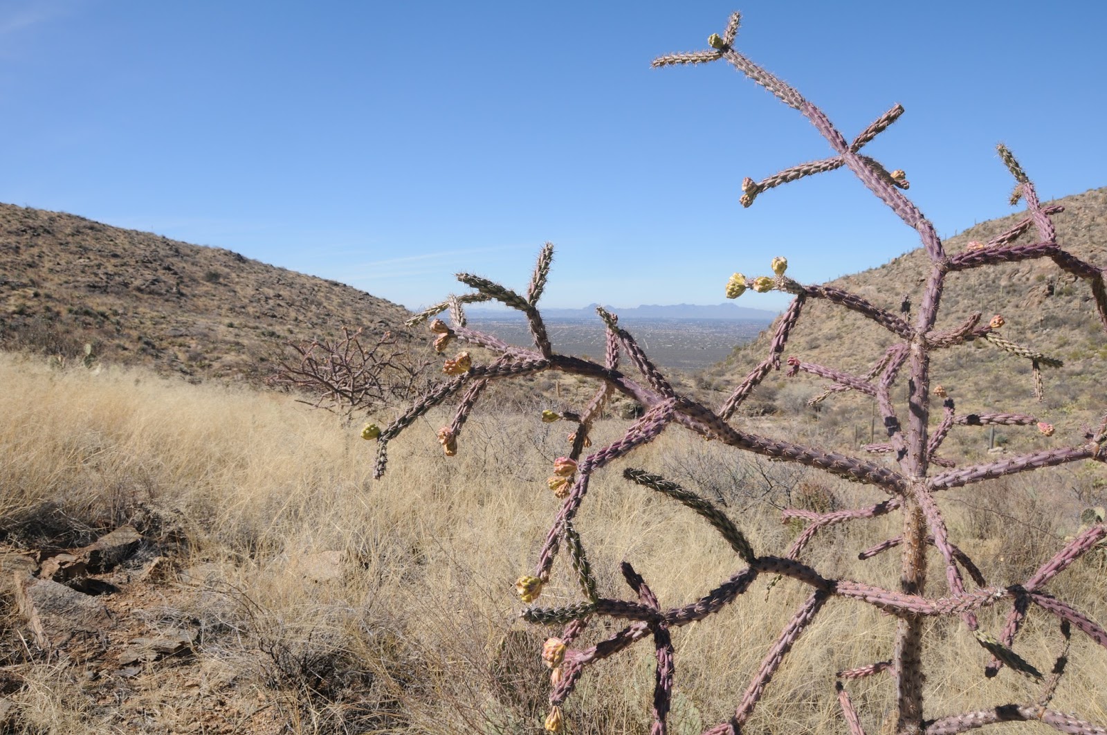
WOODCHUTE MOUNTAIN TRAIL
Woodchute Wilderness Area
Woodchute Trail
Cooler temperatures and shorter days of autumn work together to paint the oak trees on Woodchute Mountain in a palette of orange and gold. The mountain is really more of a long ridgeline with Prescott Valley on one side and grand views of the red cliffs of Sedona and the peaks of Flagstaff on the other. Easy-to-follow, trail No. 102 meanders 3.7 miles up the mountain on a moderate slope that swings from east to west showcasing vistas of much of northern Arizona.
Beginning at 7,000', the hike culminates with an easy stroll across a breezy high prairie that dead-ends at the 7,600' east face of the mountain. Here, blood-red maples and honey-colored scrub oaks frame views of Jerome and the Verde Valley.
Gambel oaks on Woodchute Trail, Oct. 17th
GETTING THERE: From Jerome, go 7 miles southwest on State Route 89A to the turn off for Potato Patch Campground. Turn right and continue .3 mile to the signed road for the Woodchute trailhead on the left and follow it to a parking loop with restrooms. Those without a high clearance vehicle should park here. To find the trailhead, head right (east) and hike or drive (high clearance needed) up Forest Road 106 (also signed as FR 102/106) for a half-mile to the wilderness sign and trail register. If you opt to hike the road, add 1 mile to the trip length above.
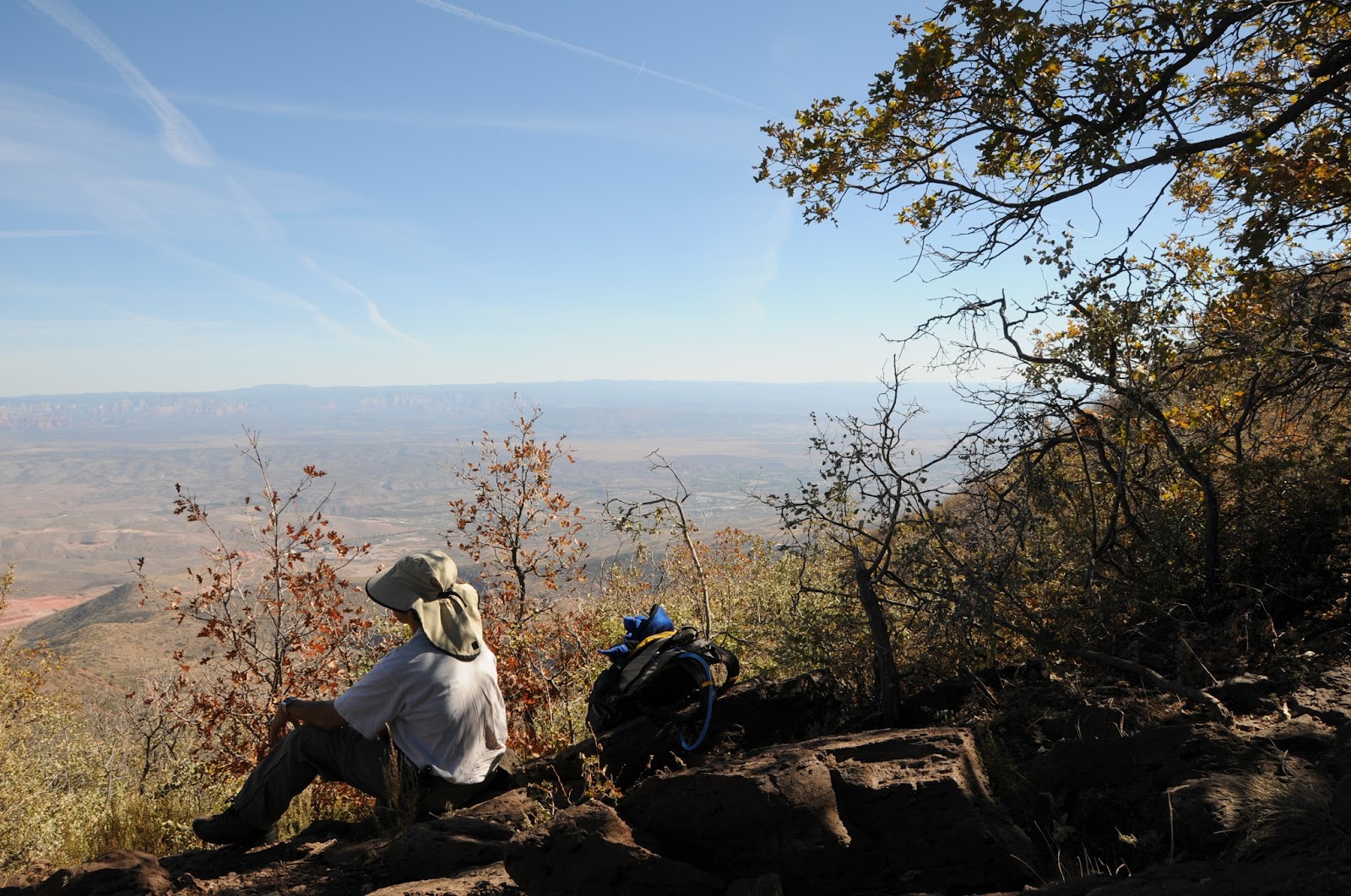
VIEW POINT TRAIL
Prescott National Forest
View Point Trail, Oct. 10th
A traipse through an archway of toasty golden oaks sets the stage for the hallmark mountain vistas and brilliant foliage of the View Point Trail No. 106. Beyond this “grand entrance” the slender path begins its gradual, 2-mile descent along the east face of Mingus Mountain weaving through a mixed bag of terrain including exposed juniper-agave high desert and pine-oak forests fringed with Big-tooth maples. From the trail’s high vantage point, the towns of Jerome and Cottonwood appear like scribbles on a map far below while the course of the Verde River paints a lazy swath of green on a brown landscape. Just past the 1.3-mile mark, at the junction for trail 105A, the route makes a severe dip into the canyon. It’s here where the hike rating goes from moderate to difficult as the path clamors roughly 700 feet downhill on loose rocks to the turn around point at Allen Springs Road. Casual hikes can opt to stay on the high road and make the junction their turnaround point instead. Elevation range is 7,800' - 6,000'.
View Point Trail, Oct 10th
GETTING THERE: From Jerome, go 7 miles southwest on State Route 89A to Mingus Mountain Road (Forest Road 104). Turn left and continue on FR 104 for 2.4 miles to where it ends at a “T” intersection in the campground. Take an immediate left and park in the circular turnout near the “106” trail sign.
NORTH MINGUS TRAIL
Prescott National Forest
North Mingus Trail, Oct 11th
An eclectic mix of scenery and forests are the highlights of the North Mingus Trail No.105. Although there are two trailheads for this route, most hikers choose to start at the top of Mingus Mountain and hike downhill. That’s because the route is easier to follow when hiked in this direction. Right from the start, this popular trail will “wow” you with magnificent views from 7,800 feet atop a pine-shaded hang glider launch pad.
Here, the rugged Verde Valley rolls out 1,600 feet below. The 8.5-mile roundtrip hike begins with a pleasant stroll across the mountain summit under a canopy of warm gold Gambel oaks huddling beneath enormous conifirs. After this short “warm up” section, the trail dips downhill along the north face through colorful corridors of Big-tooth maples, boxelders and velvet ash. Soon, the path enters an enchanting passage where a mass of volcanic boulders cascade down a slender slot canyon where vertical stony walls and a stand of aspens thrive in the cooler microclimate. Past the aspen grove, the trail enters a more arid clime with intermittent sections of grasslands, fields of agave and ridgelines studded with whispy mountain mahogany. An abandoned mine marks the point where the trail merges with an old Jeep road that leads downhill to Mescal Spring at 6,000 feet, the turnaround point for the hike. This trail also can be hiked one-way using a car shuttle at each trailhead.
North Mingus Trail, Oct 11th
GETTING THERE: Mingus Mountain trailhead: From Jerome, go 7 miles southwest on Highway 89A to Mingus Mountain Road (Forest Road 104). Turn left and continue on FR 104 for 2.4 miles to where it ends at a “T” intersection in the campground. Turn left here and go uphill to the trailhead near the hang glider launch pad. Mescal Spring trailhead: From Jerome, go 4 miles southwest on Highway 89A. Just before sign for Prescott National Forest, between mileposts 339 and 338, turn left onto an unmarked dirt road (Forest Road 338). FR 338 is a very rough 4x4 road so those without appropriate vehicles should park in the turnouts along the highway. Continue down FR 338 for a half-mile to the cement tank that marks Mescal Spring. From here, veer right (southwest) and go uphill. Bear left at all unmarked junctions until you reach the signed turn off for trail No. 105 on the right. This route adds one mile to the hike description above.