Find A Trail. Start Your Search Here:

Showing posts with label Cave Creek. Show all posts

Tuesday, December 5, 2023

Maricopa Trail to Camp Creek Falls

MARICOPA TRAIL SEGMENT 22

BARTLETT DAM ROAD to CAMP CREEK FALLS

Camp Creek in Tonto National Forest

Over its 315+-mile course, the Maricopa Trail unfurls its tendrils to link county regional parks, suburbs, urban public spaces, canals, historic paths, and remote stretches of national forest.  To hike the full loop is tantamount to a walking tour of the Valley’s multi-faceted landscape. 

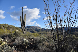
Mountain vistas on the Maricopa Trail

The epic non-motorized route that circles the Valley broke ground in 2007 in the Spur Cross Ranch Conservation Area, and the main loop was completed in 2018. 
Hikers in the Camp Creek Falls grotto

The trail continues to improve, evolve, build connectivity, and add length as it adapts to accommodate growing community interest and enthusiastic hiker, biker, and equestrian users.  Built to encourage hikers of every ilk to get outdoors, the route’s many trailheads and neighborhood access points make it simple to hop on and off the trail from anywhere in the Valley, with two notable exceptions: the Spur Cross to Bronco and Bronco to Granite Mountain segments. 
Segment 22 of the MT is wide and well signed

Where the northernmost segments of the trail pass through Tonto National Forest, there’s an average of 13 miles between drive up trailheads. And, for seasoned, well-prepared trail users, that’s where the best stuff resides.  Segment 22 which runs for 16-miles from the north border of Scottsdale’s McDowell Sonoran Preserve to the Bronco trailhead in Tonto National Forest was among the last passages to be completed. 
The trail heads downhill on brushy foothills

Rugged terrain, scoured washes, nasty back roads and stubborn rock contributed the difficulty encountered by trail construction crews. Then, in September and October 2020, the 15,000+-acre Sears Fire took a toll on several miles of the segment located roughly 20 miles northeast of Cave Creek.  
Hazy Mt. Ord (center horizon) viewed from the trail

Within months, work crews restored the damaged trail, fixing drainages and stabilizing eroded slopes.  While the moderately difficult entire 12.6-mile Segment 22 hike can sound intimidating for some, there’s an option for an out-and-back day hike that includes a visit to one of the Valley’s most beloved natural wonders.
Morning vista on the Maricopa Trail

Beginning along Bartlett Dam Road, Segment 22 heads north through a shadeless expanse of catclaw and saguaros.  The path briefly traces a powerline, but then veers east into wash-riddled backcountry with unobstructed mountain views.  The rocky domes of Kentuck Mountain (5,013 feet), Maverick Butte (4,870 feet), Humboldt Mountain (5, 204 feet)and St, Clair Mountain (3,252 feet) populate foreground with Mount Ord (7,128 feet) and the cloud bumping Mazatzal Range standing high over the Verde River Basin in the distance. 

The Maricopa Trail crosses sandy Blue Wash

The trail twists downhill, clinging to foothills and stony edges landing hikers at the sandy corridor of Blue Wash at the 3.4-mile point. 
Where the MT crosses Bartlett Dam Road

From a barbed wire and wood gate, an American flag planted on a prominent knoll with a Fresco Mines claim sign across the wash marks the beginning of a side trip to Camp Creek Falls. 
Interesting rock formations throughout the hike

The side trip veers left from the Maricopa Trail and follows the glassy slip of Camp Creek to a box canyon where a perennial stream of water spills about 20 feet over solid rock into a shallow plunge pool.  Desert waterfalls are rare enough, but this one in its tiny grotto fringed by cottonwoods, willows and reeds is a real gem.
Camp Creek leads to a desert waterfall

 
Flag (center) on knoll marks the falls side trip

The spring-fed fount is a critical water source for the deer, javelina and myriad little critters that live in the surrounding desert and makes for a scenic stop over for both long-distance treks and short day hikes on the Maricopa Trail.
The spring-fed waters of Camp Creek Falls

SUPPORT THE TRAIL:


If this wild and wonderful segment of the Maricopa Trail has inspired you, please consider supporting the effort by attending the Prickly Pedal Bike Race, the trail’s main fund-raising event.

Prickly Pedal on the Maricopa Trail will run 36 miles from Cave Creek to Lake Pleasant in Peoria.

The annual event is produced by Aravaipa Rides to benefit the Maricopa Trail + Park Foundation which funds trail building and maintenance projects.

Heads up that trail closures will be in effect along the racecourse.

RACE: 8:30 (pre-registration required)

EXPO & AFTER PARTY: 11 a.m. – 3 p.m.

Public is invited to enjoy the finish line party with beer garden, exhibitors, music, and fun.

https://pricklypedal.com/


LENGTH: 7 miles round trip, out-and back to the falls

RATING: moderate

ELEVATION: 2,833 – 3,303 feet (793 feet of elevation change)

GETTING THERE:

SOUTH TRAILHEAD

BARTLETT DAM ROAD-WILDCAT HILL OHV PARKING:

From Loop 101 in Scottsdale, take the Pima/Princess Drive exit 36 and go 13 miles north on Pima and turn right on Cave Creek Road.  Continue 4.1 miles to Bartlett Dam Road, turn right and go 0.4-mile to a dirt road on the right 0.1-mile past the Tonto National Forest ranger station.  Turn right and park along the dirt turn outs. Follow the Maricopa Trail signs to cross Bartlett Dam Road and continue north.

TONTO NATIONAL FOREST CAVE CREEK RANGER STATION:

40202 N. Cave Creek Road, Scottsdale.

May be closed on weekends and holidays.

Use the 0.2-mile connector that starts at the big Maricopa Trail kiosk.

INFO & MAPS:

https://www.maricopacountyparks.net/park-locator/maricopa-trail/


Friday, January 14, 2022

Tortuga-Spur Cross Loop

TORTUGA-SPUR CROSS LOOP

The pachyderm profile of Elephant Mountain


A quick loop hike in Spur Cross Ranch Conservation Area north of the town of Cave Creek  yields a heart-stirring trip through canyons, saguaro-fleeced slopes and a rare desert waterway, all backed with outstanding mountain views.

Saguaros cling to slopes below the CaveCreek Mountains

 
The short, but steadily challenging hike ties together two of the Maricopa County Regional Park’s trails into one stunningly tour of Sonoran Desert diversity.

From the trailhead, begin by hiking northwest (go right and downhill) on the Spur Cross Trail which is also part of the Valley-circling Maricopa Trail.  In less than a half-mile, the trail crosses Cave Creek.

Skull Mesa viewed from the Tortuga Trail

 
Fed by storms and snowmelt, water runs sporadically through the rocky channel and is usually at its height during the winter and spring months.  A few yards past the creek crossing, continue north on Spur Cross from the Metate trail junction keeping an eye out for the foundations of the defunct Spur Cross dude ranch crumbling among cholla and creosote shrubs.
Sun-lit saguaros glow on the Tortuga trail

Over the next 0.6-mile, the route climbs easily, opening views of the creek gorge below and the flat-topped tableland of Skull Mesa and Sugarloaf Mountain to the northeast. One mile in, pick up the Tortuga Trail  which signals the beginning of a steady ascent on a degraded dirt track that hangs on the cusp of a ravine flush with acres of saguaros, prickly pear, ocotillo and cholla that glow in thorny halos when backlight by the sun.

A crossing of Cave Creek comes early in the hike

The 1.1-mile uphill section is heralded by a sign warning of primitive conditions ahead. 
The as-advertised primitive trail

While the route is indeed rough, it’s not too difficult to follow. Soon, more vistas open to the south. 
Benches for viewing at the top of the loop

Look for Cave Creek classic, Black Mountain, the Cave Creek Mountains, the long profile of the McDowell Mountains and singular Pinnacle Peak on the horizon.
Sugarloaf Mountain (left) seen from Tortuga trail

 
This hike uses the Spur Cross & Tortuga trails

The circuit tops out at the Elephant Mountain trail junction where the best glimpses of the 3,926-foot massif’s pachyderm profile command attention.  A couple of benches overlooking the mark the spot where the Tortuga trail begins a 0.6-mile downhill trek toward the leafy cut of the Jewel of the Creek Preserve. 
Tortuga trail is rough but not hard to follow

To finish up this loop hike, head left at the Dragonfly trail junction and follow the Spur Cross trail as it switchbacks through a deep gully on its way back to the trailhead.

LENGTH: 5.3 miles

RATING: moderate

ELEVATION:  2,340 -2,615 feet

GETTING THERE:

44000 N. Spur Cross Road, Cave Creek

From Loop 101 in Phoenix, take Cave Creek Road north to Spur Cross Road (on the left just as you enter the downtown area) and go 4.5 miles north to the parking area. 

FEE: $3 per person daily fee. Bring exact change.

INFO:

https://www.maricopacountyparks.net/park-locator/spur-cross-ranch-conservation-area/


Monday, January 10, 2022

Walnut Spring Canyon

WALNUT SPRING CANYON

Cottonwoods herald the approach to Walnut Spring

There are more than seven springs in the Seven Springs Recreation Area.  The Tonto National Forest site which offers a picnic area, primitive camping and trailheads anchored by the Cave Creek Trail No. 4 is home to dozens of seeping water sources.

Humboldt Mountain rises over desert scrub

In addition to the eponymous Seven Springs, Maggie May, Mashakattee, Quien Sabe, Walnut, CP and Cottonwood springs spill water into the area’s creeks and washes.

Big vistas on the hike's high points

 
The route crosses Walnut Spring Canyon several times

A quick review of the national forest map reveals the locations of numerous other springs tucked into the mountainous backcountry north of Cave Creek.  While some of the springs are located along roads and trails, most trickle in oblivion among catclaw-riddled ravines.
The hike begins with a crossing of Seven Springs Wash

A lone sycamore grows in a moist pocket of Walnut Spring Canyon

 
Among the lot, Walnut Spring is easy to visit by hiking along a dirt two-track that roughly traces the gorge of Walnut Spring Canyon.  
A canyon-bound section of FR 1094

The trip begins on Forest Road 254 with an immediate crossing of Seven Springs Wash.  Right from the start, charred tree stumps stand as reminders of the 2005 Cave Creek Complex Fire and the 2020 Sears Fire, both of which took a heavy toll in the area.  Still, plenty of hardy junipers, sugar sumacs and cacti patches have survived and resurgent vegetation is gradually filling the charred voids.  At the 0.3-mile point, the road meets a cattle guard where the route splits.  Veer right onto Forest Road 1094, a rough route that’s open to motorized use, which serves as the trail for the remainder of the hike. 
Yuccas grow in a canyon cove

The road passes under some power lines where there’s a muddy wildlife water hole that reflects nice views of 5,175-foot Humboldt Mountain, the prominent, FAA “golf ball”-tower-topped peak to the east.  An easy ascent opens up vistas of the Cave Creek Mountains and the long, flat structure of New River Mesa to the west before the road meets the cut of Walnut Spring Canyon at the 1.2-mile point and begins a moderate descent to the first of several crossings of the sinuous, boulder-cluttered course.  Sheer rock faces with clinging cacti and yuccas dangling from damp crevasses gradually close in on the road and create shallow, sandy pools in abrupt bends.  The residual puddles foster a tiny community of water-loving sycamore, seep willows and cottonwood trees. 
A metal tank captures water from Walnut Spring

After a short traverse of the canyon floor, the road heads uphill, hanging close to the edge as it undulates through water-ravaged gullies and drainages.  The approach to Walnut Spring is heralded by a pair of cottonwood trees poking up through a tangle of junipers and a glassy slip of water running over the road.  At 2.6 miles, a metal tank tucked into a slim, heavily-wooded nook, captures Walnut Spring water through a quagmire of pipes and hoses.
Sugar sumac grows along the route

  While the spring makes for a good turnaround point, a short stroll up to the ridge above it rewards with excellent mountain views of Bronco Butte and Butte Peak to the south.
New River Mesa on the west horizon

 
A view of the Cave Creek Mountains from FR 1094

To add length to the hike, consult the forest map for roads and trails open for exploration.
Cottonwood trees thrive around Walnut Spring

The road passes by a wildlife water hole

LENGTH: 5.34 miles roundtrip

RATING: moderate

ELEVATION: 3,440 – 3,946 feet (1,012 feet of accumulated elevation change)

GETTING THERE:

From the Loop 101 in Scottsdale, take the Pima/Princess Road exit 36 and go 13 miles north on Pima to Cave Creek Road.  Turn right (east) and go 11 miles on Cave Creek Road (a.k.a Forest Road 24 and Seven Springs Road) to Forest Road Road 254 on the right. For reference, this is about 1.5 miles south of the Seven Springs Picnic Area. Park in the dirt turnoff or, for those with high-clearance vehicles, there are several dirt parking aprons farther up FR254.  Access roads are a mixture of pavement and good dirt passable by passenger cars when dry. Two minor creek crossings on cement are require. Do not attempt after heavy rains as the roads and trails are prone to flooding.

INFO:

Tonto National Forest, Cave Creek Ranger District

https://www.fs.usda.gov/tonto

Tuesday, March 23, 2021

Clay Mine Trail

CLAY MINE TRAIL

Beautiful mountain and valley views on Clay Mine Trail

In the ubiquitous quest for health and beauty, the promise of a quick fix seduces better than the long game.  For those rare few who won the beauty and longevity genes lottery (I’m looking at you Sophia Loren and Cicely Tyson) having a great face and physical fortitude without investing in a whole lot products is an enviable characteristic.  The rest of us use mud.

Join a ranger-led hike to explore inside the mine

While luxurious, earthy promise-in-a-jar blends available at health-and-beauty counters everywhere from discount stores and late-night infomercials to indulgent destination spas provide a feel-good boost and a surface glow, they rarely cure anything.  Still, dangling carrots endure, and people have made billions selling muddy treatments promoted as healthful and youth-restoring.  Thus, was the case of Leila P. Irish.

Creosote shrubs bloom even in drought conditions

In the 1930s, the entrepreneurial woman saw the potential in marketing a buff-colored clay found among the tailings of an abandoned, dud gold prospect in what is now Cave Creek Regional Park.  For reasons unbeknownst to modern science, Irish envisioned a miracle cure in the otherwise unremarkable, chalky rock.  She transformed the common earth into a marketable gold mine of another type by grinding the soft sediments into a fine, talc-like powder and selling it at premium prices as a calcium, iron and silica rich health supplement and basic elixir for building strong teeth and nails and enriching blood.  The product took off, making Irish and her Pearl Chemical Mine very wealthy.

Clay mine treasure: miracle cure or snake oil?

When Irish’s dreams of further cashing in on the magic muck by establishing a nearby health resort complete with therapeutic mud baths didn't pan out, she sold the claim in 1949 and the mine and its sensational issue of debatable value fell into oblivion. 

Today, the clay mine lives on as a curiosity site in Cave Creek Regional Park.  To get a close-up look at the mine’s innards and learn more about the history and science behind the bizarre bit of Arizona lore, sign up for a tour led by park rangers.  But if you’re fine with just a look in from behind a locked gate that protects the cave, grab a park map and head out on your own. 

Benches are placed at scenic spots on the trail

The 1.5-mile Clay Mine Trail may be accessed from either the Overton or Go John trailheads near the park nature center and can easily be looped into longer, more difficult hikes. 
Big valley views on the way to Clay Mine

Rock outcroppings line the route

As a standalone trek, the route rolls through desert hills and high passes with outstanding views of the Valley and surrounding mountain ranges.  With the ongoing drought, wildflowers are scant this year.  But hearty, desert plants like creosote, brittle bush and desert marigolds have mastered the long game and push through with spots of beauty along the way.
There are many ways to extend the hike

LENGTH: 3 miles round trip

RATING: easy

ELEVATION:  2,000 -2,300 feet

GETTING THERE:

Cave Creek Regional Park, 37900 E. Cave Creek Parkway, Cave Creek.

Take Interstate 17 north to Carefree Highway (State Route 74). Head east (right) and continue 7 miles to the park entrance at 32nd Street.  Follow the main park road to the Overton or Go John trailheads at the nature center.

There are restrooms and water at the trailhead.

PARK HOURS: 6 a.m. to 8 p.m. daily

FEE: There’s a $7 daily fee per vehicle.

INFO & MAPS:

https://www.maricopacountyparks.net/park-locator/cave-creek-regional-park/

Wednesday, January 6, 2021

Get Hooked on the Maricopa Trail in 2021

SPUR CROSS-MARICOPA TRAIL

Beautiful back country on the Maricopa Trail

Sometimes, an addiction is a good thing.  Swapping a junk food obsession or a movie streaming fixation for a commitment to healthful foods and regular outdoor recreation are the kinds of addictions that improve quality of life.  Kicking bad habits isn’t easy, but hiking can help wean even the most devout triple-burger-with-the-works aficionados off the artery-hardening stuff.

The route crosses Cave Creek several times

That’s because, like eating potato chips, once you start, it’s difficult to stop.  And when you really get into it, you’ll be inspired to get fit to take on longer, more difficult treks.

A bird verifies Audubon Arizona important bird area

As with goals in general, it helps to have a plan. 

An old forest service sign on the Maricopa Trail

For Phoenix-area hikers, there’s a ready-made plan already in place. It’s called the Maricopa Trail.  The 315-mile route circumnavigates the Valley, connecting 10 county regional parks, urban centers, suburbs and national forest trails.  Outfitted with dozens of trailheads and community access points, the trail is easily accessed from anywhere in the Valley.  While the route is still expanding and improving, the main course is complete. There’s a beginning, middle and end which makes it a perfect choice for anybody who wants to earn the feeling of accomplishment that comes with completing a long-distance hike without committing to a months-long, non-stop journey. This one can be knocked off in approachable day hikes. 
The Maricopa Trail is 315-mile route

The route passes through a stony corridor

Of course, to get “addicted” it’s best to start with the juiciest segment.  While naming the “best” segment of the Maricopa Trail is purely subjective, the bit that goes from Spur Cross Ranch Conservation Area in Cave Creek to the Skull Mesa trailhead in Tonto National Forest is as fine a candidate as any.

Rich in biodiversity, ecozones, history and scenic beauty, this short, easy hike is a great way to sample and possibly get hooked on the Maricopa Trail. Begin by hiking north on the Spur Cross Trail, an old ranch road that has been incorporated into the trail.  Right from the start, the hike embodies a remote feel as it delves into hilly back country along the leafy corridor of Cave Creek.  The waterway fosters a healthy community of cottonwoods, sycamores and mesquite trees where many species of birds thrive in the area that has been named an important bird area by Audubon Arizona. 

An abandoned corral on the Maricopa Trail

The Tonto National Forest boundary

After a mild uphill walk and a couple of usually dry creek crossings, the trail enters Tonto National Forest. Staying close to the creek bed, the last mile passes through rocky corridors and cliffs cluttered with enormous saguaros. A few creek hops later, the path meets the Skull Mesa trailhead where a vintage wood sign displays a map and key mileage notes.
Huge saguaros grow along the route

From this point, the Maricopa Trail continues on through one of its most remote, rugged and mountainous sections.  But for an introductory outing, the wood sign makes for a good turnaround point that will inspire you to come back for more.
Elephant Mtn is a dominate feature on the hike

LENGTH:  4 miles roundtrip

RATING: easy

ELEVATION: 2,263 – 2,407 feet

GETTING THERE:

Spur Cross ranch Conservation Area:

37622 N Cave Creek Road, Cave Creek.

From Loop 101 in Phoenix, take Cave Creek Road north to Spur Cross Road (on the left just as you enter the downtown area) and go 4.5 miles north to the parking area. 

FEE: $3 per person daily fee. Bring exact change.

INFO:

https://www.maricopacountyparks.net/things-to-do/activity/maps/