Find A Trail. Start Your Search Here:

Showing posts with label Ridge Trail. Show all posts

Monday, November 7, 2022

Secret Slickrock Circuit

SECRET SLICKROCK CIRCUIT

Water pools on the Secret Slickrock Trail

It’s a rare hike that packs in as much over-the-top awesomeness as the Secret Slickrock trail.  Short in length but serving up a generous dose of Sedona scenery, the 0.4-mile route with outlets on Chavez Ranch Road and Red Rock Crossing Road appears on maps as if it goes nowhere in particular.

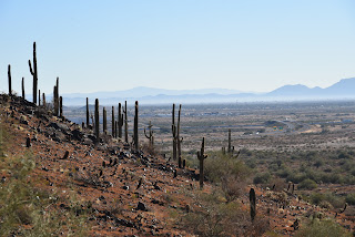
Bradshaw Mountains view on Secret Slickrock

In fact, it goes everywhere without going too far.  That might sound like a contradiction, but the trail’s position high above Oak Creek is a unique eye-candy platform.
Drainage crossing on Ramshead Trail

On paper it reads like a touristy step-out, but when tied into a longer trek using the Carroll Canyon Area Trails network, it’s a confectionary capstone.

Located at the end of a paved street in west Sedona opposite a popular roadside overlook, the Secret Slickrock trail is not so secret.

Extend the hike using Carroll Canyon Area trails

Marked only by a blink-and-you’ll-miss-it trail sign that competes with the marquee attraction across the road, it’s low key presence doesn’t scream epic journey. But, like an icy shower, this one wastes no time delivering the shock factor.
Bear Mountain seen from the Ridge Trail

Red rocks and gullies on Ramshead Trail

However, scenic climaxes such as this one are best experienced with a little foreshadowing.  By looping it up with the Coconino National Forest Old Post, Ramshead and Ridge trails, the journey is a slow burn to the in-your-face final act.

Go either way at the Ridge Trail junction

Beginning at the Old Post trailhead, which is little more than a dirt turn out, the circuit heads north to connect with the Ramshead trail. Ramshead rolls out the teases with peeks at Cathedral Rock, the distant Bradshaw Mountains and the leafy course of Oak Creek and its floodplains.
Scenic overlook opposite the Secret Slickrock trailhead

The trail crosses a road and continues up russet sandstone ledges to meet the Ridge Trail junction where hikers may go either right or left to get to Secret Slickrock. For this trip, go left, hike 0.4 mile and head right and trudge 0.1-mile up paved Chavez Ranch Road to the scenic overlook parking area.
High desert flora on the Secret Slickrock Trail

The overlook serves as the hike’s penultimate moment.  

A fugitive cairn (center right) on Secret Slickrock

A bare rock ledge hangs over Oak Creek and the Crescent Moon Picnic Area that’s world famous for its access to one of the most photographed sites in the Southwest, the towering spires of Cathedral Rock reflecting into the river.  While the spot is great for making pretty pictures, the big show happens across the road where junipers shade the sign for the Secret Slickrock trail. A brief section of level trail opens up views of Sedona’s chiseled land forms all around before encountering an abrupt edge where a steep staircase-like trail marks the descent to a massive stone platform.
Autumn color along Oak Creek seen from Secret Slickrock

The open air, bald stage is home to a convergence of blue sky, red rock towers and the tree-cluttered course of Oak Creek flowing below. 
Cathedral Rock viewed from Secret Slickrock

Capitol Butte viewed from Secret Slickrock

The tiny paradise is a microcosm of everything Sedona. It has reflecting pools like the remote and difficult Cow Pies Trail without the effort to get to them. Heavenly views of iconic vortex Cathedral Rock looming over Oak Creek, without the crowds. A mix of cactus-and- yucca-studded high desert grasslands and 360-degree mountain vistas all in one place.
Maps like this one are posted at trail junctions

Closing up the loop hike can be tricky because the trail disappears on the slickrock. Only fugitive basket cairns mark the sketchy route that descends to reconnect with the Ridge Trail.  The trail is there, but route-finding and attention to uneven footing are required for those looking upgrade from the 5-cent tour.

Grasslands and mountains on Secret Slickrock

LENGTH:  5 miles round trip as described here

RATING: moderate

ELEVATION:  3,955 – 4,185 feet

GETTING THERE:

Old Post Trailhead:

From the State Route 179/89A traffic circle in Sedona, go 4 miles west (toward Cottonwood) on SR 89A to Upper Red Rock Loop Turn left and continue 1.8 miles to Chavez Ranch Road (Forest Road 216A), turn left and go 0.1 mile to the Old Post trailhead on the left.

To drive to the Secret Slickrock trailhead, continue on Chavez Ranch Road to the trailhead located a few yards past the Forest Road 788A junction at a road gate. The trail begins across from the parking apron and forest service kiosk.

INFO:

Coconino National Forest

https://www.fs.usda.gov/recarea/coconino/recarea/?recid=72089

Monday, December 20, 2021

Spine Trail

SPINE TRAIL

Casa Grande Mountain Park.

Desert vegetation in Casa Grande Mtn Park 

The Casa Grande Mountains form an abrupt divide in a landscape commandeered by busy transportation corridors, cotton fields, irrigation canals and desert basins dotted with neon signs denoting truck stops, road side motels, feed stores and RV parks.
Arica trailhead in Casa Grande Mtn Park

The north-south running range is situated where Interstate 8 swerves west off I-10 and railroad tracks funnel  snake-like streams of freight cars through dusty flatlands.

The Picacho Mountains seen from the park

 Awash in the sounds of train horns and the rumble of big rigs, Casa Grande Mountain Park, with its over 17 miles of non-motorized recreational trails, presents a tetchy truce with the roar of commerce grinding below its slopes.
Saguaros clutter the slopes of Casa Grande Mtn

The trails trace the east flanks of the mountain in long, loopy segments that alternately climb to high-point vistas and duck through drainages and rocky bends that momentarily muffle the cacophony of cars and cargo carriers.

A hawk takes flight with a meal in its grasp

 While the soundtrack is a near-constant companion, the trails seem to blend well with the rural-railway theme—apart from but part of the area’s ambiance.  After a few miles of hiking, the ambient din reinvents itself from flaw to supporting character.
Dawn and dusk are the best times to see hawks

The noise is a little jarring at first, but the weirdness is quickly absorbed as trail users step into the hilly 1,025-acre Pinal County park where interesting geology, desert vegetation and a robust wildlife community demonstrate how nature and industry can share space.

Trail post marks theturnaround point for this hike


Arranged in interconnected coils, the trail system is designed for easy customization. 

Neon signs glow below Casa Grande Mtn

The downloadable park map and trail posts are color-coded: blue for easy, green for moderate and black for difficult.  Two long anchor routes, the Spine and Ridge trails, serve as main arteries from which several connecting paths diverge. 
Palo verde trees shade the trail

For an easy- moderate-rated taste of the park, begin at the Arica trailhead.  From the kiosk, follow the access path and veer right onto the Spine trail, which stays low on the mountain’s eastern front.
Extend the hike on any of the park's17 miles of trails

At the first trail post, head right and continue north among giant saguaros and boulder-jumbled washes.  The open country makes for prime hunting grounds for hawks that wait atop saguaros ready to make a meal of any reptile, small mammal or bird that shows itself.
The industrial-wild flavor of Casa Grande Mtn Park


To the southeast, look for the profiles of Picacho Peak and the Picacho Mountains backed by the distant Tortolita and Santa Catalina Mountains near Tucson.  Several unsigned paths and roads cross the trail over the first mile.  Just stay on the well-worn main route. At B-2 GPS marker, the trail splits.  Both legs are about the same length but the “blue” choice offers a moderate hike while the “green” side remains easy.

Picacho Peak (R) stands over an agricultural valley

Both reconnect then split again before converging at the A-5 GPS marker at the 1.48-mile point where hikers can double back or connect with the Ridge Trail for a more challenging return route. 
Trail whistles are the soundtrack of the hike

Spine trail splits into easy and moderate legs

Either way, this easy-access mountain destination at the intersection of workloads and wilds delivers a rewarding day of hiking. Train horns and all.
Giant saguaros are a common site in the park

LENGTH: 3.29 miles roundtrip as described here

RATING: easy-moderate

ELEVATION: 1,505 – 1,626 feet

GETTING THERE:

Arica Trailhead, 2090 E. Arica Road.

From Interstate 10 in Casa Grande, take the Sunland Gin Road exit 200.  Turn right at the bottom of the offramp and continue a short distance south to Arica Road on the right just past the Love’s Truck Stop.  Follow Arica Road 1.6 miles to the trailhead. Roads are 100% paved.

There’s a porta potty at the trailhead but no other facilities.

INFO & MAPS:

City of Casa Grande

https://casagrandeaz.gov/cg-mountain-trails-project/


Monday, February 5, 2018

OLD POST-CARROLL CANYON LOOP

OLD POST-CARROLL CANYON LOOP
View of Capitol Butte (Thunder Mountain) from Ridge Trail
Recent trail development in the southwest corner of Sedona has added miles of fresh dirt in the hilly terrain between Airport Mesa and Oak Creek.  Routes like Skywalker, Scorpion and Pyramid are terrific supplements that connect to a maze of old standards, providing additional access points and myriad opportunities to create loop treks. 
Wilson Mountain seen from Carroll Canyon Trail
Before exploring the new and shiny, take a walk on the original, well-worn Carroll Canyon Area Trails for an overview of the what makes this pocket of high desert and deeply scoured gullies so special.  Downloadable forest service maps and signs posted throughout make the system easy to navigate the core trails--Carrol Canyon, Ridge, Herkenham and Old Post.  Whichever way you lace this one up, be sure to include the 1.8-mile Carroll Canyon Trail because you won’t want to miss the best part—a dizzying traverse above a twisting limestone valley.
Here’s one circuit to try. 
Smoke Tree
From the Old Post trailhead, hike 1.1 mile uphill through patches of thorny Smoke Trees and yuccas with big views of Courthouse Butte, Bell Rock and Cathedral Rock on the southern horizon.  Turn right onto Carroll Canyon Trail and get ready for more stunning beauty. The route ascends along jagged sandstone and rough-cut steps to emerge at a scenic vista point. Here, glimpses of Capitol Butte (a.k.a. Thunder Mountain) and the flat-topped form of Wilson Mountain appear to the north.  
View of famous Sedona formations seen from Old Post Trail
The trail then ducks into juniper-cypress woodlands before rounding a bend where the contorted course of Carroll Canyon rolls out below.  A short passage hugs the lip of the steep-walled gorge that plunges 200 feet with views of Oak Creek and its surrounding floodplains peeking through the cracks.  It’s a queasy, edgy walk that ends with a descent into the first of several boulder-cluttered wash crossings.  Once through the wash, the route enters a savannah-like grassland, fringed with mesquite and the occasional cottonwood. 
One of several wash crossings on the route
At the next junction, pick up the Ridge Trail, hike 0.7-mile north and reconnect with the Old Post Trail for the final leg of the loop.  But the scenic wonders aren’t done yet. The back end of the circuit keeps delivering surprises.  
The limestone abyss of Carroll Canyon
Sunny plains sliced and diced into a jigsaw puzzle of flat fields, abrupt climbs and a web of water-whittled muddy ravines define the trail as it brushes past suburban homes before a powerline signals the final descent back to the trailhead.
A Shady passage of Carroll Canyon Trail
LENGTH: 5.5 miles
RATING: moderate
ELEVATION:  4090 to 4440 feet
GETTING THERE:
From the State Route 179/89A traffic circle in Sedona, go 4 miles west (toward Cottonwood) on 89A to Upper Red Rock Loop (Forest Road 216). Turn left and continue 1.8 miles to Chavez Ranch Road (Forest Road 216A), turn left and go 0.1 mile to the Old Post trailhead on the left.
INFO: Coconino National Forest

Monday, November 16, 2015

CASA GRANDE MOUNTAIN TRAILS

CASA GRANDE MOUNTAIN TRAILS
Casa Grande
The Ridge Trail 

Casa Grande Mountain Park resides in the desert space between a world of truck stops and freeways and valleys of checkerboard farmlands. Here, mornings break to the hum of traffic, blaring train horns and veils of mist drifting off crops. Despite its proximity to the busy Interstate 10/8 interchange, the park has quality hiking, especially at its southern end where the din of industry is absorbed in cholla-fleeced foothills and stony clefts.
The 1,025-acre park has more than 18 miles of non-motorized use trails. The system is made up of stacked loops with varying levels of difficulty anchored by the 4.86-mile Ridge Trail that traces the mountain's eastern flank. Although the Ridge Trail is well-signed, some of the others are not, but finding your way around isn't too tough. Also, because wildcat social trails muddle the terrain, it's smart to download the park map before heading out. Official trails are marked by metal posts with arrows that use standard alpine color codes (black for difficult, blue for moderate, green for easy). Follow the posts to stay on track.
Two trailheads offer distinctly different experiences. At the north end, the Peart Trailhead appeals to those looking for easy, close-to-town hiking, while the Arica Trailhead provides access to the park's midsection and more difficult options.
While on the trail, scan the horizon for the profile of Picacho Peak and the jagged silhouette of the Sawtooth Mountains. Underfoot, look for the Arizona Fishhook Pincushion cactus that appears to grows out of solid rock in calf-high clusters blooming pink in spring before producing cherry-red fruits that linger through winter.
LENGTH: 18.29 miles
RATING: easy to difficult
ELEVATION: 1,500' - 2,350'
FACILITIES: porta potty, interpretive sign, benches, trash can
GETTING THERE:
Peart Trailhead:
From Interstate 10 in Casa Grande, take the Jimmie Kerr Blvd. exit 198 (State Route 84) and travel 2.6 miles west to Peart Road. Turn left (south) and continue 1.7 miles to where a "hiker" sign points to a dirt road on the left. Follow this sedan-friendly road 0.4 mile to the trailhead.
Arica Trailhead:
From Interstate 10 in Casa Grande, take the Sunland Gin Road exit 200 and head 0.1 mile south to Arica Road (just past the Loves truck stop). Turn right and continue 1.5 mile to the trailhead. The last half-mile is on rough dirt but is passable by sedan.
INFO & MAPS:
MORE PHOTOS: