Find A Trail. Start Your Search Here:

Showing posts with label Legends of Superior Trail. Show all posts

Wednesday, February 2, 2022

Legends of Superior Trail: Queen Creek Canyon

LOST: QUEEN CREEK CANYON SEGMENT

Boulders line the upper part of the Queen Creek Canyon hike

Imagine the trip from Phoenix to the Copper Corridor towns of Globe-Miami taking all day. That was the reality back in the early 20th century before U.S. 60 replaced the old Apache Trail route. While the annual Renaissance Festival traffic might still make the trip feel like a lurching marathon, the highway shaved the 88-mile drive time down to about an hour and a half.

Inside the defunct Claypool Tunnel

The highway’s original, “million-dollar-a-mile” sinuous alignment opened in 1922.  

Ruins of mining equipment visible on the hike

Convicts were used to build parts of the route, including the Claypool Tunnel near the town of Superior, which was blasted from solid rock in the rugged cliffs above Queen Creek Canyon.
Hike follows the 1920s alignment of U.S. 60

 
The current U.S. 60 bridge spans Queen Creek

While known for its fabulous views, the narrow, edge-hugging road with hairpin turns and queasy drop-offs proved just too dangerous for modern travel needs.  So, the route was retooled in 1952 to its safer, current alignment which includes the slick (yet claustrophobic) Queen Creek Tunnel. 
The rough-blasted interior of the Claypool Tunnel

A 1920s-era bridge crosses Queen Creek

But the decommissioned U.S. 60 didn’t just disappear. Its crumbling course, which is now on Resolution Copper property, has been repurposed into a recreational trail that’s part of the Legends of Superior Trails (LOST) system.
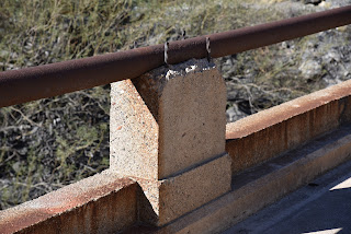
Early 20th century masonry work

Picketpost Mountain and the Superior water tank

 
Located roughly 65 miles east of Phoenix, the 11.65-mile  LOST system is divided into 5 segments open to hiking, biking and equestrian use.
Sycamores grow in the riparian zone around Queen Creek

Each segment explores a unique slice of Superior’s history and environmental diversity. There’s the stunning riparian corridor of Arnett Canyon with connectivity to the Arizona National Scenic Trail, a walk through the abandoned town of Pinal and an interpretive in-town stroll among artifacts from the area’s rich mining and ranching heritage.  But it’s the Queen Creek Canyon segment that gives a boots-on-the-ground tour of the defunct highway.
Close up of the 1952 Queen Creek Bridge


The 4.2-mile out-and-back hike begins on the outskirts of the historic downtown business district.  Following the disintegrating substrate of pavement and gravel, the old highway traces the bed of Queen Creek where bits of old mining equipment and barred-off prospects teeter over the usually dry waterway. 

The Claypool Tunnel was blasted from solid rock

Throughout the hike, a palpable push-pull of old and new defines the mood, beginning with the crossing of a 1920s-era concrete bridge that stands below the gargantuan span of its metal-riveted replacement bolted into vertical cliffs soaring above the sycamore-lined creek. Among eroding culverts, barriers and drainage systems, interpretive signs augment the trek with information on local wildlife, geology and history.  About halfway through the hike, the road swings around a water tank and begins a winding ascent through a geologically complex zone of quartzite, limestone and volcanic tuff--an amazing display 540 million years in the making.
Mineral-rich geology in Queen Creek Canyon

Interpretive signs augment the hike

On its way uphill, the trail unpacks views of 4,377-foot Picketpost Mountain and the remote, chiseled landscape of Alamo Canyon and Tonto National Forest to the southwest.

Abandoned mines are dangerous. Stay on the trail.

The crumbling foundation of old U.S. 60

The trail tops out at the old Claypool Tunnel.  It’s a short, sort of creepy, walk through the rough-blasted stone tube that lands hikers just yards beyond its replacement on the new U.S. 60.  For average-paced visitors arriving from Phoenix, the hike takes about as long as the drive to the trailhead, Fair traffic notwithstanding.

LENGTH: 4.2 miles roundtrip

RATING: moderate

ELEVATION: 2,807 – 3,485 feet

GETTING THERE:

Magma Avenue Trailhead:

From U.S. 60 in Superior, take the Kearny/Winkelman exit 227 for State Route 177. At the top of the offramp, go left and merge onto Magma Ave. (toward the business district) and continue 0.2-mile to the intersection of Magma Ave. and Heiner Dr. where there’s a dirt parking area. Hike begins at the gate at the north end of the lot.

INFO:

Legends of Superior Trails

https://superioraztrails.com/


Monday, March 25, 2019

Legends of Superior Trails: Arnett Canyon Trail segment

Legends of Superior Trails: Arnett Canyon Trail segment
Arnett Creek is a key feature of the LOST system
Picketpost Mountain looms over the LOST 
The new LOST trail segment connects with the AZT
“When I first hiked the Legends of Superior Trails, I had no clue how awesome they are,” says Mila Besich, Mayor of the Town of Superior.  “After the hike, I felt like crying but I wasn’t sure if it was because of the overwhelming beauty or because I had gone nearly nine miles,” Besich laughed. 
Hikers descend a steep section of the new Arnett Canyon Trl. 
Speaking at the March 24, 2019 inauguration of the new Legends of Superior Trails (LOST) Arnett Canyon segment, Besich acknowledged the many individuals and organizations that contributed to the planning and construction of the fresh-cut, 1.5-mile trail section that connects with the Arizona Trail at the Picketpost Trailhead off U.S. 60. 
A steep, narrow section of the trail.
Arnett Creek flows through volcanic terrain.
While leaders at the Tonto National Forest, Resolution Copper, Arizona Trail Association and the Town of Superior did the governmental and land management red-tape wrangling, young American Conservation Experience workers did much of the shoveling and sweating to build the singletrack path that can be hiked as a loop or a one-way trek to the historic Pinal Townsite that’s part of the LOST system of interpretive routes that explore the town’s history and mining heritage.
Hikers in Arnett Canyon
Wildflowers grow among outcroppings of volcanic ash.
Although the mountain-bound community sits in the heart of the mineral-rich Copper Corridor just an hour east of Phoenix where mining is a core industry, Besich is quick to point out that the area’s treasures extend beyond its ore.
Mila Besich, Mayor of the Town of Superior in Arnett Can.
“We’re not a mining town. We’re a town with a world-class mine,” she emphasized.  Cognizant of the boom-and-bust nature of the mining business, the town ranks its natural outdoor assets as being as important as any commercial enterprise. The improvement and expansion of the LOST hiking hub is part of the town’s diversification objectives to boost the economy while staying true to their roots.  “The project is a marathon,” Besich said. “LOST is a start, and we envision Superior becoming home to the next best hiking destination in Arizona.”  This ambitious goal includes plans for a 110-mile stacked-loop trail system that will wind through rugged back country and the Queen Creek-Arnett Creek watersheds south of town. The project—which will use the LOST system as an anchor-- is currently in the planning and permitting process and if all goes well, construction could begin in the next couple of years.  In the meantime, hikers can enjoy the many miles of outstanding existing trails in Superior. 
Situated at the crux of two of the state-traversing Arizona Trail’s most spectacular desert passages that meet at the base of volcanic Picketpost Mountain, the newly completed Arnett Canyon Trail segment is a segue to a landscape of amazing biodiversity, history and complex geology. 
Globemallow bloom along the trails.
The segment begins near the site host campsite with an uphill walk and views of the Superstition Wilderness. Other than a short section where the trail descends steeply on a narrow, rocky ridge that’s not recommended for bike or equestrian use, the hike is effortless.
Hikers on the LOST loop approach the Picketpost TH 
Where the route brushes the flanks of Picketpost Mountain, hikers might be inspired to climb to its 4375-foot summit by way of a sketchy and difficult spur path off the Arizona Trail.  At the 0.6-mile point, turn right and pass through a gate to complete the 1.5-mile loop. Or, to extend the hike, continue straight ahead into Arnett Canyon for a drop-dead-gorgeous, out-and-back creekside trek smothered in greenery and pillars of petrified volcanic ash.  It won’t take too many miles of hiking to understand why Besich says this enchanting trail system is, “a dream come true” and a key inspiration for the reimagination of a desert town.
LOST is just the beginning of a planned hiking hub.
Volcanic rock formations in Arnett Canyon
Superstition Wilderness vistas seen from LOST
LENGTH: 1.5-mile loop
RATING: easy
ELEVATION:  2461 – 2342 feet
GETTING THERE:
Picketpost Trailhead:
From U.S. 60 just before entering the Town of Superior between mileposts 221 and 222, turn right at the Picketpost Trailhead sign and continue 1 mile to the parking area. Roads are paved and maintained dirt suitable for all vehicles. There is a restroom at the trailhead. The trail begins near the site host campsite.
INFO:
Legends of Superior Trails
Arizona Trail

Tuesday, January 31, 2012

Upcoming guided hikes event in Superior

Mark your calendar: Legends of Superior Trails (LOST)  Ecotourism Festival  Saturday, Feb. 18, 2012 !
Picketpost Mountain

Take a guided hike on the Arizona Trail beneath Picketpost Mountain and walk the Legends Of Superior Trail that connects the historic mining town of Superior with the Arizona Trail, 6 miles to the west. Food, fun, and hiking in a street fair setting.  REGISTER ONLINE: Superior Chamber of Commerce: