


 Posts
Posts


HAU 'PAL LOOP
 |
| Sierra Estrella Mountains peek over Ma Ha Tauk range |
Situated in the northwest sector of South Mountain Park in Phoenix, the Hau’pal trail fixes a couple of things.
 |
| Camelback Mountain has some competition in the Hau'pal Trail |
First, the 3.2-mile loop which debuted in 2020 replaces a quagmire of confusing, terrain-damaging park (remember the T-Bone Trail ?) and sloppy user-created paths. Newly aligned, signed and cleaned up, the route is now a safer, more sustainable trek.
 |
| Difficult-rated Hau'pal trail is well signed |
Second, it provides swift attitude adjustment for anybody who thinks a short loop hike located a mile south of downtown Phoenix can’t deliver a heart-pumping-- and sort of scary--hike.
 |
| Piestewa Peak rises above downtown Phoenix |
 |
| The route is steep, edgy and rocky |
The 3.2-mile loop, which is named for the O’odham word for red-tailed hawk, progresses in three distinct episodes. Heading counterclockwise from the trailhead (go right), the hike begins with an immediate uphill haul that gets gradually steeper as the dirt single track gains over 1000 feet twisting over clipped shelves and stony folds in the far edge of the park’s Ma Ha Tauk Range.
 |
| Mountain & urban views on Hau'pal trail |
Act two involves a breath-taking walk over a sheer ridgeline with vistas that span the entire Valley and reach into the mountain peaks of the Tonto National Forest and farmlands south of Ahwatukee.
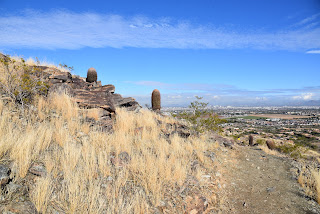 |
| First leg of the hike gains elevation gradually |
Narrow, steep and, in places, very close to sheer drop offs, the ridge leg of the hike is not for acrophobics.
 |
| The trail replaced old and unauthorized paths |
The final segment is preceded by a short scramble through a rock chute before the trail calms down and swings downhill on gully-riddled foothills with scenic lookout points that frame views of city grids, urban landmarks and the distinctive humps of Camelback Mountain—another short, steep hike destination that might lose its “ultimate city hike” panache once Hau’pal catches on.
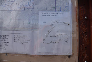 |
| Map at the trailhead shows the loop layout |
LENGTH: 3.2-mile loop
RATING: difficult
ELEVATION: 1,320 – 2,359 feet
GETTING THERE:
Form Phoenix, travel south on 7th Avenue to Baseline Road. Turn right (west) and continue on Baseline to 19th Ave. Turn left (south) and follow 19th Ave to the trailhead. No facilities.
INFO:
https://www.phoenix.gov/parks/trails/locations/south-mountain


