Find A Trail. Start Your Search Here:

Showing posts with label Payson. Show all posts

Monday, April 11, 2022

Forest Road 502 to East Verde River

FOREST ROAD 502 to EAST VERDE RIVER

A calm bend in the East Verde River near Payson

From sweeping mountain vistas, to rolling, juniper-dotted rangeland and a leafy river canyon, a walk along Forest Road 502 delivers a packed agenda over its short, hilly course. 

View of North Peak from FR 502

Adopted by the Tonto Recreation Alliance, a non-profit, volunteer partner of Tonto National Forest that works to keep hundreds of miles of forest trails open and maintained for motorized off-road use, the dirt two-track a few miles west of downtown Payson offers a quick, lightly trafficked route to the East Verde River.
High desert valley vistas abound on FR 502

Sego lilies bloom Apr - July

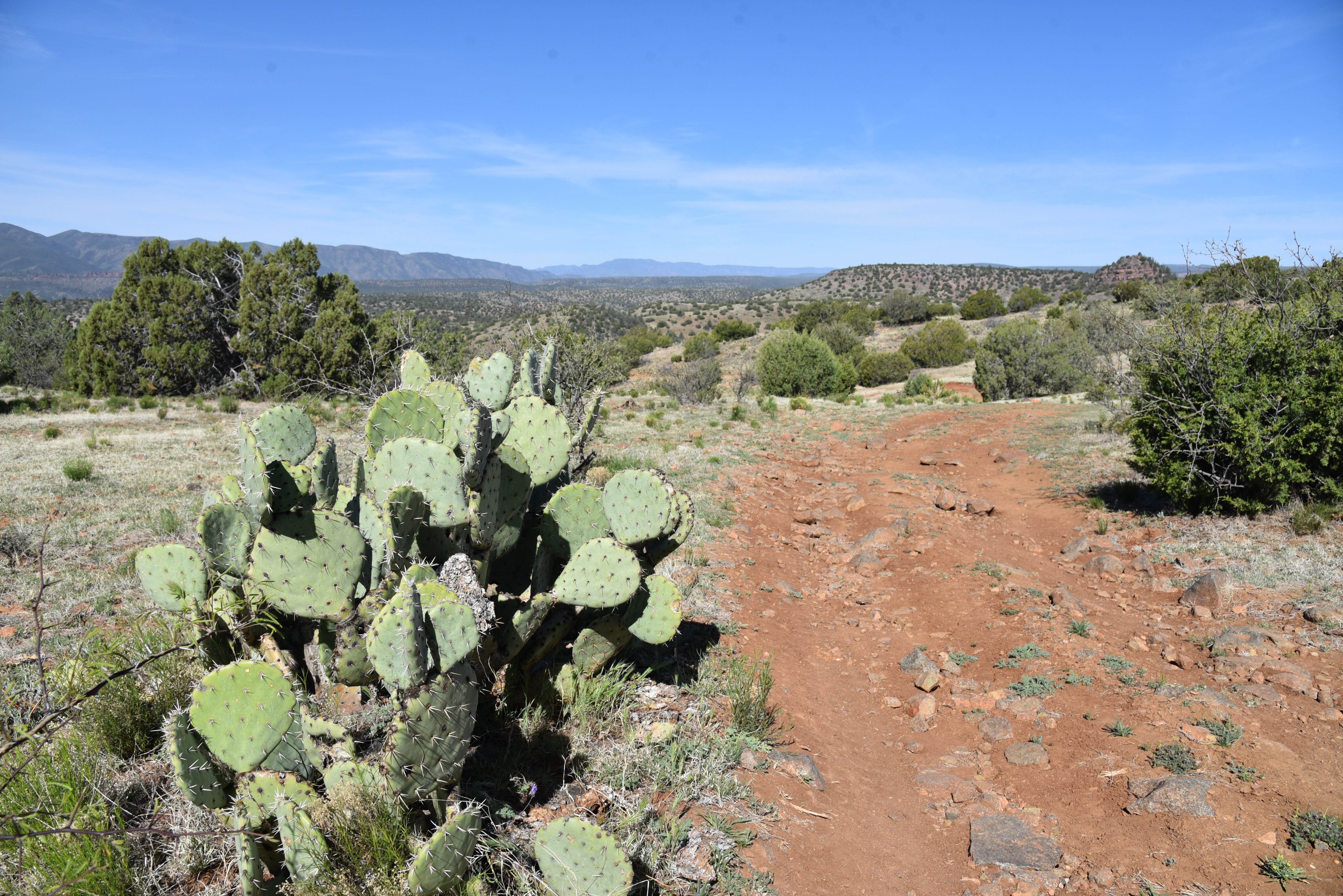
Located a few miles south of Tonto Natural Bridge State Park east of Pine Creek, the road, which is open to hikers, equestrians and OHV use is a sweet find for those who appreciate a simple trek peppered with many points of visual interest.
You might encounter livestock on FR 502


From a dirt pull out along Doll Baby Ranch Road, the hike begins by passing through a barbed wire gate (close it behind you) where visitors are immediately smacked with breathtaking views of  Mazatzal Wilderness peaks including 7,449-foot North Peak, the northernmost  prominent peak in the Mazatzal Range.

Goodding's verbena blooms Feb - Oct

Barberry shrubs bloom Feb- May

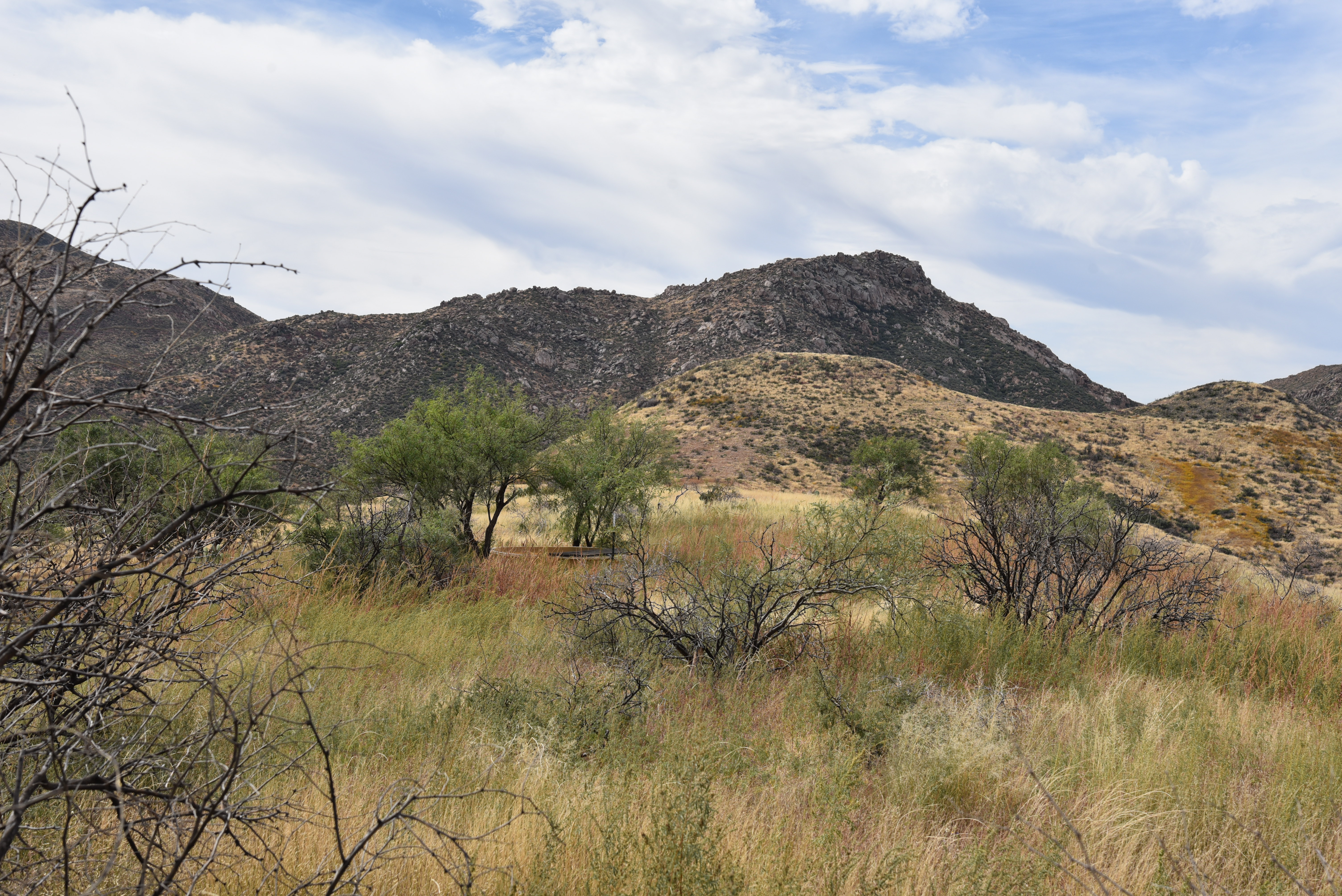
The road veers left at an unsigned fork at the 0.1-mile point. After that, all junctions are signed “502”.  As the road makes an easy push through sunny juniper-pinon open range, views of a landscape rife with landforms with imagination-stoking names like Polles Mesa, Whiterock Mesa, White Hills, Horsethief Bench, Limestone Hills and Pilot Knob roll out in all directions.
Milkvetch is a common spring bloomer

Majestic land forms all around.

The largely unshaded route is flanked by a fringe of flowering shrubs, yucca and a colorful understory of classic high-desert wildflowers including delicate sego lilies, purple Goodding’s verbena, milkvetch, Blackfoot daisies and flame-red paintbrush. 

Velvet ash trees huddle around East Verde River

At just over the one-mile point, the road begins a series of gradual ups-and-downs that land hikers at the East Verde River. The final,  descent into the river canyon is somewhat rocky and steeper, but not too difficult.
Paintbrush bloom Mar - Sep

The road meets the water at 1.8 miles where hikers may explore along the rocky banks and spindly velvet ash trees to spy trout swimming in deep pools.
Trailhead on Doll Baby Ranch Road

Road ups and downs total over 780 feet in elevation change

While the river makes for a good turnaround point, hikers may consult the Tonto Recreation Alliance downloadable maps to extend the trip by way of several connecting roads.
Blackfoot daisies bloom Mar- Dec


LENGTH: 3.6 miles roundtrip (to the river and back)

RATING: moderate

ELEVATION: 3,717 – 4,058 feet (781 feet of accumulated elevation change)

GETTING THERE:

From State Route 87 in downtown Payson, go 6.3 miles west (go left at the light) on Main Street which will turn into Country Club Road and then Doll Baby Ranch Road (FR 406) to the trailhead on the right.  Park in the dirt turn outs by the gate and the “502” sign.

INFO & MAPS:

Tonto Recreation Alliance

tralaz.org


Monday, October 25, 2021

Bushnell Tanks Road

BUSHNELL TANKS ROAD

First crossing of Sycamore Creek is sort of tricky

Sometimes, surprisingly fine escapes can be found just steps from busy byways in right-under-your-nose places.  Bushnell Tanks Road, located off the Beeline Highway roughly halfway between Mesa and Payson is one such find.

Rustic corral site is a highlight of the hike


Much of the road parallels part of the course of the Pine Mountain Passage 21 of the Arizona National Scenic Trail using backroads above and through the corridor of Sycamore Creek and Colcord Canyon.

Sprawling grasslands dominate the high ridges

 
It’s a rugged, undulating road hike in Tonto National Forest that’s packed with creek side sycamores, a rustic corral, stunning desert vegetation and huge mountain vistas. 
Buffalo gourds dangle from a mesquite tree

The moderate hike is also a great who-knew way to view breath-taking late autumn foliage. 
The rocky second crossing of Sycamore Creek

The hike plan is simple, although roads and junctions are not signed, so paying attention to landmarks is key to staying on track. 
A mix of riparian and desert trees shade the hike

From the trailhead, hike down the main gravel road which is Bushnell Tanks Road, Forest Road 22.  At the 0.3-mile point, the road meets the turn off for the Arizona Trail connector. 
Devil's Claw blooms through October

Stay on the main road as it descends to the first of three gorgeous crossings of Sycamore Creek.  The first crossing is a little sketchy. 
Mount Ord stands out over rangelands

The road goes straight across the braided and bent waterway, but getting through requires some creative rock hopping over the flow which varies in depth and speed with the seasons. 
An old corral complex in Ram Valley

The creek crossing is shaded with enormous sycamores and a few cottonwood, willow and alder trees that show off in shades of yellow and russet browns from late October through December. 
Hikers follow an unsigned road in Tonto NF

Once over the water, the road shimmies through a mixed bag of live oak patches and golden pastures bolstered with views of Mazatzal mountain peaks including Mount Ord, Crabtree Butte and Cypress Peak.  The road continues through a continually-changing landscape bright with wildflowers and native food plants.
Hikers approach the third crossing of Sycamore Creek

Lots of ups-and-downs and two more leafy creek hops land hikers at an unsigned road junction on the right at the 2-mile point near a rusty corral complex. 
The hike has lots of ups-and-downs

The corral makes for an interesting exploratory side trip.  Encroached with weeds, tangles of buffalo gourds and bits of frayed ropes, the maze of metal fencing, feed troughs and a newish-looking water tank sit at the core of scenic Ram Valley.  When done investigating the corral, backtrack to the road junction and follow the steep, rutted path up a catclaw-riddled ridge. Long pants, folks.
Hike gives an alternative look at AZ fall foliage

 
Concrete tank marks the hike turnaround point

The unforgiving haul unpacks spectacular views with every foot of elevation gained.  Peaks and buttes circle an environment of sprawling rangeland, deep valleys and tree-lined creek channels. 
Hikers on one of the hike's high ridges

At the top of the first rise, the road begins a relentless series of ascents and descents through open grasslands.  At the 3.9-mile point, on a bald high-point, a concrete stock tank off to the right sits among a ring of mesquite trees and low-growing cacti.  This makes for a good turn around point. 
Sycamore seed pods

For a longer trip, consult the Tonto National Forest map to scope out other routes that wind through the hills and connect with the Arizona Trail.
Extend the hike on AZT or other forest roads

Better yet, check out the Arizona Trail website (aztrail.org) for more ways to experience this beautiful slice of Central Arizona. 

FR22 traces the course of Sycamore Creek

Arizona Trail association members also get special access to maps, data and privy to dozens of loop hike options using the 800+-mile, state-traversing trail.
Desert hackberry shrubs clutter in a wash

LENGTH: 7.9 miles roundtrip

RATING: moderate

ELEVATION: 3,320 – 3,817 feet (1,720 feet of accumulated elevation change)

GETTING THERE:

From Loop 202 in Mesa, take the State Route 87 (Beeline Highway/ Country Club Road) exit 13.  Go 41 miles north on SR 87 to the turn off for Bushnell Tanks near the community of Sunflower.  Park in the gravel lot near an “area closed” sign and a large Arizona Trail kiosk.  The area is open to non-motorized use.

INFO:
https://aztrail.org/explore/passages/passage-21-pine-mountain/

Monday, April 12, 2021

Crackerjack Road

CRACKERJACK ROAD

The FR 209 crossing of the East Verde River

From its source on the Mogollon Rim near Washington Park north of Payson, the East Verde River flows southwest through Tonto National Forest, feeding a gorgeous swath of greenery before merging with the Verde River. 
The first part of the hike follows Ash Creek

Over its 34-mile length, the central Arizona waterway cuts through a transitional landscape where the desert creeps up against sheer rock escarpments at the edge of the Colorado Plateau trickling down from an environment of tall pines and forest lakes into high desert scrub and rugged backcountry of the Mazatzal Wilderness.  
Milk vetch is a common bloomer along the hike

Where the tributary stream wraps around Houston Mesa Road at its confluence with Ellison Creek, the Water Wheel group of recreation sites attract anglers, bathers and hikers. 
Riparian corridor of the East Verde River

Those who don’t mind crowds, noise and hefty day-use fees will have a blast at these splashy, easy-access hot spots.  But for a less congested look at the waterway’s midsection, take a stroll on a nearby back road. 
FR 209 crosses Ash Creek several times

More plod than plunge—don’t bother packing a swimsuit-- this moderate hike follows Forest Road 209 that’s also known as Crackerjack Road.  
Sycamore and chiseled cliffs line FR 209

The dirt track, which is part of the Payson OHV Trails system, begins 3 miles north of town off State Route 87.  From the highway, it’s just over a 3-mile hike to the East Verde, but it’s the stuff in between that makes this walk memorable. 
Crossing at the East Verde River

Seeds of an ash tree

The road traces the course of Ash Creek, crossing it several times as it makes a gentle descent through pine woodlands.  The first mile passes by many campsites used by OHV enthusiasts but soon leaves the party scene behind and enters a stunning, canyon-bound riparian corridor. 
Shaggy, green-white bark of an AZ sycamore

Lined with sycamores, cottonwoods and the eponymous ash trees, the trip unpacks amazing views of sculpted cliffs and scoured ravines.  At the 2-mile point near where some powerlines cross the route, the road emerges from the deep woods around Ash Creek and heads uphill where the gaping gorge of Horton Canyon stand out to the south.  
Fresh sprouts on an ash tree

At the top of a rise, first glimpses of the river’s emerald entrenchment winding past the East Verde Estates community come into view.  To the north, peeks at the distant flat-topped Mogollon Rim barely rise above a terrain of endless gullies, hills and juniper flats.  From this point, the road dips downhill paralleling the river’s flood plains.
Vegetation thrives along Ash Creek

The road heads uphill near Horton Canyon

Corralled by colorful stone embankments rubbed smooth by running water, the East Verde River crossing is a beautiful little place with room to explore along its banks. 

Gregg's ceanothus shrubs smell like lilacs

Still pools, clear cascades and tumbling mini waterfalls reflect russet rock walls and leafy fringes for many perfect photo opps.  

The hike turnaround point is where clumps of reeds and saplings encroach upon a concrete slab that spans the water and a Salt River Project water monitoring station stands near a massive cottonwood tree.  For a longer albeit dryer and hotter hike, follow the road another 4 miles to the Crackerjack Mine site, otherwise, backtrack and enjoy the watershed in reverse.

Peaceful scene along the East Verde River

LENGTH: 6.4 miles round trip to the river and back.

RATING: moderate

ELEVATION: 4,389 – 4,831 feet (1,083 feet of accumulated gain)

GETTING THERE:

From the State Route 87/260 junction in Payson, go 3 miles north on SR 87 to Forest Road 209 at milepost 256 on the left.  Park in the dirt turnout or continue along FR 209 to one of the many parking aprons and campsites along the road.  The road is sedan-friendly for about one mile. 

INFO: https://www.tralaz.org/


Friday, October 2, 2020

Shannon Gulch

SHANNON GULCH

FR 74 leads into Shannon Gulch

More than 2,000 feet above where the East Verde River crosses State Route 87 north of Payson, snowmelt and rainwater that will eventually drain into Arizona’s rivers and streams begins with a journey through porous escarpments before spilling through springs at the base of the Mogollon Rim. 

The shrubby folds of Shannon Gulch

Below the Rim’s vertical cliffs that rise to over 7,000 feet and make a 200-mile, east-west stretch through central Arizona, an edgy, almost claustrophobic territory of high mesas, dizzying gorges and backwoods is home to a maze of tributary creeks and drainages that feed into the East Verde River which in turn flows into the Verde and Salt Rivers, two of Arizona’s most important water sources. 
Mogollon Rim vistas from the road's highpoint

A hike through this tangled, geologically and botanically diverse region is as much an origin story as it is a walk in the woods.
Milk Ranch Point, promontory on the Mogollon Rim

While the nearby 50+ mile Highline Trail, which is part of the Arizona National Scenic Trail, clings to the craggy Rim walls, the terrain farther downhill is a more bucolic, less precipitous place.

Several rough dirt roads venture into this scenic slice of hilly watershed.

Oak, cypress and junipers line FR 74

One to try is Forest Road 74 which makes a dive into the green folds of Shannon Gulch to explore a cloistered pocket of backcountry east of the popular Water Wheel recreation sites on Houston Mesa in Tonto National Forest.
The downhill section of FR 74 feature great views

The trek begins at a dirt turnout on Control Road (Forest Road 64), a historical route that traces the base of the rim for 23 miles between State Route 87 and just south of the town of Pine and State Route near Christopher Creek.  From the small parking area, the hike heads south following FR 74. The road is open to motorized vehicles capable of handling its rocky, twisted course, but hikers have the advantage of savoring the many natural features that unwind along the way.  

The backroads below the Mogollon Rim are scenic treasures

Cedar Mesa dominates the horizon on FR 74

Wide and easy to follow, the road hike begins with an easy walk through junipers and scrub oaks with the impressive bluff of Milk Ranch Point jutting skyward to the north and views of the Rim extending to the eastern horizon.  Over the first half-mile of hiking, the road inches up it to its highpoint where a short spur leads to a lookout mound with far-reaching views.  The panoramic vistas are swallowed up as the road begins a 500-foot descent along the edge of Shannon Gulch.
A grove of cypress trees grow near the bottom of Shannon Gulch

Making an abrupt cut in the landscape 12 miles north of Payson, the gulch is lodged between the hulking flattop of Cedar Mesa (5,542 feet) to the west and the Diamond Rim and the ragged valley cut by Webber Creek and to the east.  The rough-cut road spirals downhill passing root-tangled eroded cliffs and patches of tight-packed manzanita shrubs. 

See-forever vistas from the road to Shannon Gulch

After rounding a couple of bends, dramatic views of the Mazatzal Mountains open up to the south while the imposing nose of Cedar Mesa looms overhead.  At the 2-mile point, the road meets a junction with Forest Road 1582. This makes for a good turnaround point, but to ad length, veer right to stay on FR 74 which continues another 3.2 miles briefly following the course of Webber Creek over Deer Flat and hopping the jumbled cut of Cherry Creek before ending at a barely there turnout on State Route 87 just north of the East Verde River.

LENGTH:  5.2 miles one way or 4 miles round trip to FR 1582.

RATING:  moderate

ELEVATION:  5,400- 4,800 or 5,400 – 4,916 to FR 1582

GETTING THERE:

From the State Route 87/260 junction in Payson, go 12 miles north on SR 87 to milepost 265 (2 miles north of the turnoff for Tonto Natural Bridge State Park to Control Road (Forest Road 64).

Turn right and continue 3.3 miles to Forest Road 74 on the right. Park in the dirt turnout.  Control Road is maintained dirt suitable for all vehicles.  

INFO: Tonto Recreation Alliance

https://www.tralaz.org/