


 BOULDERS LOOP TRAIL Payson
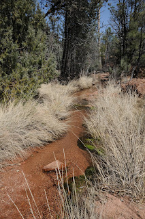
 From the looks of the deteriorating Tonto National Forest sign at the trailhead, this route was, at one time, an official Forest Service trail, which after succumbing to neglect, found some love within the Payson Area Trails System (P.A.T.S.). However, even with its new patrons overseeing maintenance, this scenic trail has yet to attract much hiker love. Maybe that’s because erosion has taken a toll on the area, and the road to the trailhead is now blocked off a half-mile from the FS sign. In fact, the old Tonto Boulders/Cypress trailhead is currently teetering on the edge of a gaping gorge and will likely fall away with the next strong monsoon. But fear not, a new trailhead has been relocated a few yards north and (for now) appears to be on stable ground. As its name implies, this trail is all about boulders. The trek is like wandering through an outdoor “art walk” among the wind-and-water-worn pink granite sculptures of southeast Payson’s Granite Dells area. In addition, the trail weaves around Stewart Creek and various watersheds that sustain a healthy forest of Ponderosa pines, cypress, juniper and riparian galleries choked with sycamores, alders and cottonwoods. According to a local hiker I ran into on the trail, this route gets few visitors. She walks the trail several times a week and rarely runs into anybody. Given that this close-to-town trail has many fine qualities--this is very surprising. Although P.A.T.S. rates this hike as “more difficult”---probably because of the loose footing and several mildly steep segments—I’m comfortable plopping it into the moderate range. The loop is made up of two trails—North Boulders and South Boulders. I elected to hike counterclockwise, beginning on the North trail, which turned out to be a good decision because most of the climbing is along this section. This hidden gem-of-a- trail deserves a lot more love than it gets---so head out there hikers, and do kissy-face with this under appreciated, sexy route.
LENGTH: 4-mile loop (including 1 mile on FR 435)
ELEVATION: 4,550’ – 4, 750’
RATING: moderate
BEST SEASON: year-round, best water March-April
GETTING THERE: From the intersection of SR87/260 in Payson, go less than a mile east on SR260 to Granite Dells Road (located just past the Safeway center). Turn right and go 3.3 miles on Granite Dells Road (which will turn into FR435 after 1.3 miles) and park at the Monument Peak trailhead on the left just before a roadblock. From here, hike down to the roadblock on FR435 and hike 0.5 mile (crossing 3 concrete bridges) to the Boulder Loop trailhead—look for a sign on the cliff wall on the left. The trail begins on the dirt road heading downhill to the right. NOTE: From the first P.A.T.S. sign above the gorge, the trail continues directly across the gorge. You can see the signs high on the opposite embankment.
(NOTE: when we hiked this trail in April 2017, this access trail had been washed away. To reach eh trail, continue another 0.25 mile down FR435 and follow the ATV track to cross the gorge) The remainder of the route is well signed except for a short section that passes through a corridor of granite. Here, look for cairns marking the way and soon you’ll pick up the P.A.T.S. signs.
OTHER ACCESS POINTS: see the PATS Web site for additional connecting trails.
INFO: Payson Area Trails System http://www.paysonrimcountry.com/MountainRecreation/HikingTrails/PaysonAreaTrailsSystem/BouldersLoopCypressTrails.aspx MORE PHOTOS: http://www.facebook.com/album.php?aid=51834&id=1795269672&l=d71015189a


 BOULDERS LOOP TRAIL Payson From the looks of the deteriorating Tonto National Forest sign at the trailhead, this route was, at one time, an official Forest Service trail, which after succumbing to neglect, found some love within the Payson Area Trails System (P.A.T.S.). However, even with its new patrons overseeing maintenance, this scenic trail has yet to attract much hiker love. Maybe that’s because erosion has taken a toll on the area, and the road to the trailhead is now blocked off a half-mile from the FS sign. In fact, the old Tonto Boulders/Cypress trailhead is currently teetering on the edge of a gaping gorge and will likely fall away with the next strong monsoon. But fear not, a new trailhead has been relocated a few yards north and (for now) appears to be on stable ground. As its name implies, this trail is all about boulders. The trek is like wandering through an outdoor “art walk” among the wind-and-water-worn pink granite sculptures of southeast Payson’s Granite Dells area. In addition, the trail weaves around Stewart Creek and various watersheds that sustain a healthy forest of Ponderosa pines, cypress, juniper and riparian galleries choked with sycamores, alders and cottonwoods. According to a local hiker I ran into on the trail, this route gets few visitors. She walks the trail several times a week and rarely runs into anybody. Given that this close-to-town trail has many fine qualities--this is very surprising. Although P.A.T.S. rates this hike as “more difficult”---probably because of the loose footing and several mildly steep segments—I’m comfortable plopping it into the moderate range. The loop is made up of two trails—North Boulders and South Boulders. I elected to hike counterclockwise, beginning on the North trail, which turned out to be a good decision because most of the climbing is along this section. This hidden gem-of-a- trail deserves a lot more love than it gets---so head out there hikers, and do kissy-face with this under appreciated, sexy route. LENGTH: 4-mile loop (including 1 mile on FR 435) ELEVATION: 4,550’ – 4, 750’ RATING: moderate BEST SEASON: year-round, best water March-April GETTING THERE: From the intersection of SR87/260 in Payson, go less than a mile east on SR260 to Granite Dells Road (located just past the Safeway center). Turn right and go 3.3 miles on Granite Dells Road (which will turn into FR435 after 1.3 miles) and park at the Monument Peak trailhead on the left just before a roadblock. From here, hike down to the roadblock on FR435 and hike 0.5 mile (crossing 3 concrete bridges) to the Boulder Loop trailhead—look for a sign on the cliff wall on the left. The trail begins on the dirt road heading downhill to the right. NOTE: From the first P.A.T.S. sign above the gorge, the trail continues directly across the gorge. You can see the signs high on the opposite embankment. (NOTE: when we hiked this trail in April 2017, this access trail had been washed away. To reach eh trail, continue another 0.25 mile down FR435 and follow the ATV track to cross the gorge) The remainder of the route is well signed except for a short section that passes through a corridor of granite. Here, look for cairns marking the way and soon you’ll pick up the P.A.T.S. signs. OTHER ACCESS POINTS: see the PATS Web site for additional connecting trails. INFO: Payson Area Trails System http://www.paysonrimcountry.com/MountainRecreation/HikingTrails/PaysonAreaTrailsSystem/BouldersLoopCypressTrails.aspx MORE PHOTOS: http://www.facebook.com/album.php?aid=51834&id=1795269672&l=d71015189a