Find A Trail. Start Your Search Here:

Showing posts with label petroglyphs. Show all posts

Monday, July 25, 2022

Picture Canyon Natural and Cultural Preserve

PICTURE CANYON NATURAL and CULTURAL PRESERVE

Bridge over the Rio de Flag

On the industrial side of the tracks a few miles east of Downtown Flagstaff, a tiny preserve set between the unglamourous footprints of a wastewater plant and public works facility interrupts the churn of municipal infrastructure with a surprising corridor of green.

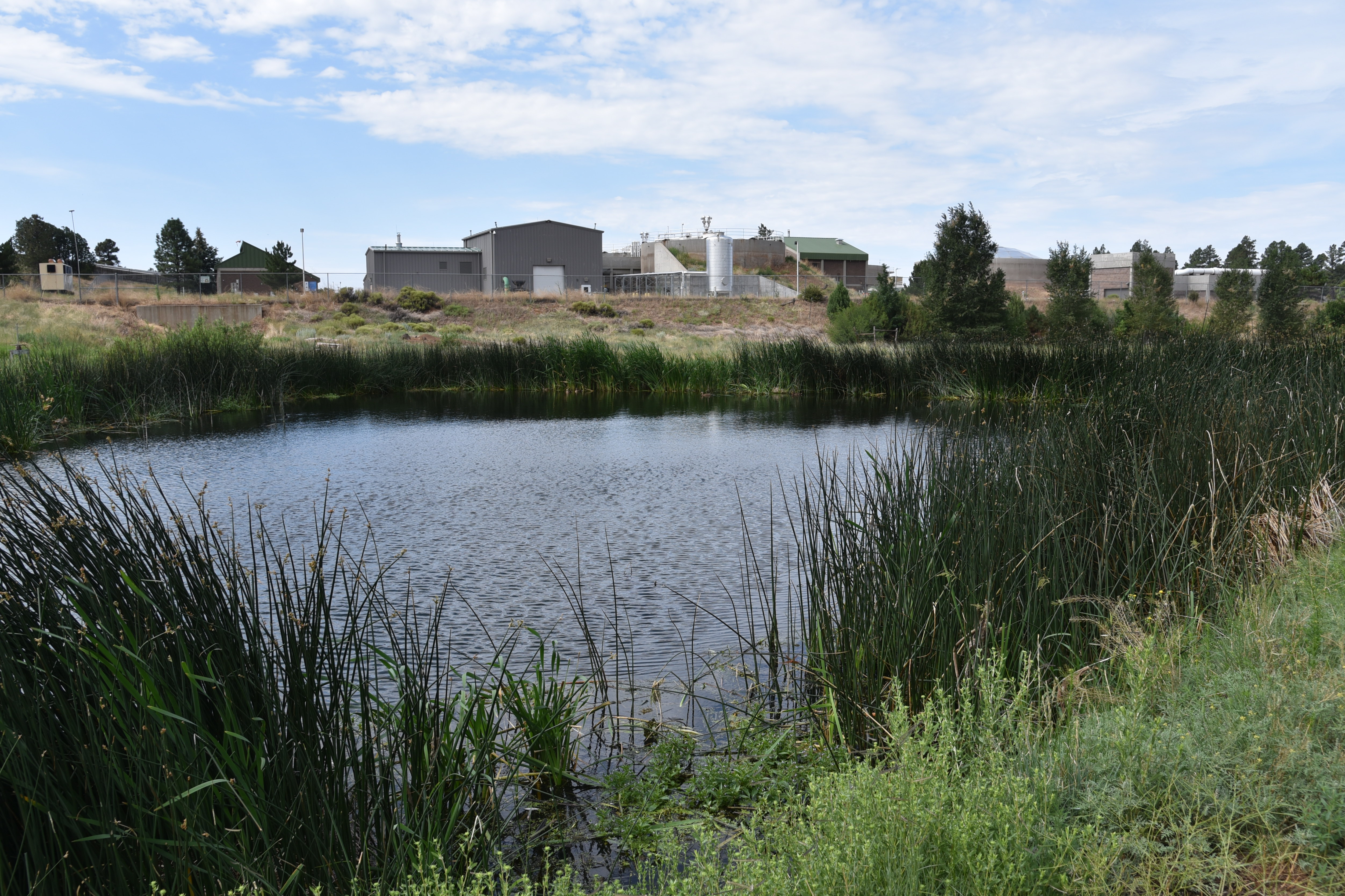
Deep water pond near wastewater treatment plant

Mt. Elden (left) and Sheep Hill cindercone viewed from the trails

Picture Canyon Natural and Culture Preserve protects a swath of rare habitats and human history huddled around a perennially moist branch of the Rio de Flag watershed, a natural stream system with headwaters at the base of the San Francisco Peaks and Mount Elden that flows in ephemeral tendrils through Flagstaff.

Slimleaf lima bean blooms May - October

Mountain tansy mustard bloom July - August

Named for panels of petroglyphs (rock art) etched into stone along one of the site’s three trails, the 478-acre parcel protects sensitive terrain, Native American heritage sites and wildlife habitats.

Along with a 1.2-mile section of the 800+-mile Arizona National Scenic Trail that bisects it, the preserve’s Tom Moody and Don Weaver trails provide easy walking tours that tie in visits to a deep-water pond, historic railroad trestle, waterfall, pithouse, petroglyphs and a crossing of the Rio de Flag waterway by way of a wooden bridge. For longer hikes, the trails also connect with the 44-mile, city-circling Flagstaff Loop Trail.

Pine-oak woodlands: one of several eco zones in the preserve

Preserve trails link with the AZT and Flagstaff Loop


The compact preserve on the drier, leeward (a.k.a. “rain shadow”) side of San Francisco Mountain packs in an amazing snapshot of Northern Arizona’s biodiversity in an ordinarily semi-arid environment.

Signs at the petroglyph site detail their significance

Buffalo gourds bloom May-Aug along the Rio de Flag

Basalt canyons, slopes and a variety of soil types create niches that foster myriad microclimate zones including meadows, pine forests, floodplains, and riparian corridors rife with willow and reeds.

A perennially flowing segment of the Rio de Flag

The preserve also serves native wildlife by providing a contiguous land bridge that allows elk, deer, and other animals to circumvent urban areas and safely cross between grasslands, forests, and wetlands.

Colorful layers of Sheep Hill cindercone

Prairie coneflower bloom Jun-Oct

Tom Moody trail traces the Rio de Flag floodplain

Listed on the National Register of Historic Places and designated as both a Northern Arizona Audubon Bird Sanctuary and an Arizona Game & Fish Department Arizona Watchable Wildlife Experience site, preserve visitors may spot waterfowl, large mammals, raccoons and more than 200 species of year-round and migratory birds.

Rock art panels decorate basalt cliffs

A map kiosk and brochures available at the trailhead give information about the site’s archeology, wildlife, and history to enrich the hike through this living sanctuary and outdoor classroom.

A waterfall trickles through a basalt canyon

LENGTH:

Tom Moody Trail: 3.9-mile circumference loop

Don Weaver Trail: 0.7-mile

Arizona Trail: 1.2 miles

RATING: easy

ELEVATION: 6,587 – 6,849 feet

GETTING THERE:

From Downtown Flagstaff, go 4 miles east on Historic Route 66, turn left on El Paso Flagstaff Road and continue 1 mile to the trailhead on the right.

INFO:

https://www.flagstaff.az.gov/2881/Picture-Canyon-Natural-Cultural-Preserve

Wednesday, June 22, 2022

Keyhole Sink

KEYHOLE SINK

Keyhole Sink surrounds a moist seep area

Not too far off Old Route 66 a few miles east of the town of Williams, a cloistered box canyon with vertical stone walls encircles a depression where water sometimes cascades over the cliffs and pool at the base of the pine-shaded oasis. 

The woodsy approach to Keyhole Sink

The sounds of tree frogs, birds, and scampering squirrels bite through a soundtrack of wind rustling through aspen canopies.  The moist, cool place vibrates with a life essence that transcends the moment.  It’s like walking through a sort of time capsule set on perennial-fill mode.
A petroglyph panel at Keyhole Sink

The Kaibab National Forest site’s ample forage grasses, water and quiet isolation made this a perfect spot for wildlife to congregate, feed, drink, and--oh yeah--be stalked.  

Aspen saplings on the Keyhole Sink Interpretive trail

From roughly 1,000 years ago, ancestral Native American hunters documented their experiences at this enchanting hideaway by pecking images of deer, bear and other local wildlife into the folds and panels of cliff faces that are the weathered remains of ancient lava flows.   Today, hundreds of the images are visible on the volcanic escarpments.
Keyhole Sink is a wildlife oasis

Dense galleries depict a vibrant, and resource-rich environment.  While the meaning and utility of the petroglyphs is best known to the makers, present day viewers may immerse in the pure beauty of the etchings and extrapolate the notes of celebrations, observations, and maybe just the plein air sketches they may have depicted.  Regardless, it’s clear that Keyhole Sink remains a living, breathing microcosm of life in the forest. 
Visitors must be front-line protectors of this heritage site

A short, interpretive trail and a descriptive brochure available online, guide visitors through the woodsy outdoor classroom.

Sadly, there’s a history of vandals defacing the rock art. Restoration involves hundreds of volunteer hours, thousands of dollars, and years of work with no guarantees of fully rehabilitating the artfacts.  Why this happens in a place that is sacred to modern Native American tribes is beyond comprehension. The place is not a “ruin”, it’s an ancestral homeland.

Although Keyhole Sink is monitored by Arizona site stewards, visitors must be the front-line protectors. As with all heritage sites, respect the irreplaceable artifacts. Do not touch or otherwise alter the rock art, stay on designated trails, pack out all trash, and leave what you find so that future generations may appreciate this Arizona point-of-pride.

LENGTH: 2 miles round-trip

RATING: easy

ELEVATION: 7,100 – 7,000 feet

GETTIGN THERE: From Flagstaff, go 16 miles west on Interstate 40 to the Parks exit 178. Connect with Historic Route 66 and go 4 miles west (left) to the Oak Hill Snow Play Area on the left. The trailhead is located across the road from the parking lot at a signed gate.

INFO:

Kaibab National Forest

https://www.fs.usda.gov/recarea/kaibab/recarea/?recid=11678


Thursday, January 28, 2021

Pima Wash Trail

PIMA WASH TRAIL

South Mountain Park

Hohokam petroglyphs on the Pima Wash Trail

Classic Arizona trails earn their reputations by being stalwart passages into some of our most beloved parks, forests and wilderness areas

Whether they are feral and remote or tame paths just steps from suburbia, these legacy routes (think: Humphreys Peak in Flagstaff, Cabin Loop on the Mogollon Rim and Bell Rock near Sedona, Peralta Canyon Trail in the Superstition Mountains and the Thumb Butte trail in Prescott) never get old.  Pima Wash Trail in South Mountain Park in Phoenix falls into the tame, nearby category and serves up a delightful trek for homegrown hikers and visitors alike.

View from the Dirt Road Trail

Located in the park’s eastern edge adjacent to a golf course and rows of trim homes and shopping centers, the trail is a mainstay in the Pima Canyon trailhead mix of routes.  Newly renovated and outfitted with restrooms, picnic tables and interpretive signs, the trailhead has plenty of parking and is designed to blend in with the surrounding desert hills. 

CCC structures on the Dirt Road Trail

Pima Wash Trail is often done as a loop hike using the Dirt Road and National Trail to tie it together.  To better appreciate the hike, start by reading the trailhead signs that describe the wildlife, vegetation and history you’ll encounter along the route. 

Petroglyphs above Pima Wash 

The short, easy loop is packed with interesting sites and is an ideal choice for keeping young kids engaged.  Begin on the Dirt Road Trail which starts at the trailhead ramadas.  The wide route heads up the edge of Pima Canyon overlooking a rugged wash.  Views of East Valley landmarks including Red Mountain and Four Peaks emerge on the horizon as the trail climbs higher into the canyon.  At near the mile point, a set of native stone buildings sit off to the left of the road.
Desert vegetation on Pima Wash Trail

These were built by the Civilian Conservation Corps (CCC), a government work program established by President Roosevelt in the 1930s.  The intricate masonry walls and arches blend easily into the natural environment and are fine examples of the many CCC-built structures, trails and other features within the park. 
Pima Canyon trailhead blends into the landscape

Just beyond the stone buildings, the road meets the National Trail junction.  Veer right and follow the trail a few yards to the Pima Wash Trail where the route ducks into a sandy, water-ravaged corridor.  Alternately staying in the cliff-bound wash and the ledges above it, the return leg of the loop tops out at a scenic point with a bench where Hohokam petroglyphs are etched into boulder outcroppings and views of the jumbled channel of Pima Canyon give cause for pause.  Vegetation in the wash is dominated by mesquite trees, brittlebush and cacti, but if you have a keen eye, you might spot a rare Elephant Tree.  While they resemble Palo Verde trees (Parkinsonia aculeata), the Elephant tree (Bursera microphylla) is a frost-sensitive tropical species in the torchwood family of plants that produces and aromatic sap similar to frankincense and myrrh. 

A petroglyph panel on Pima Wash Trail

Found in northwestern Mexico and American southwest deserts, Central Arizona, where the tree is a protected species, marks the northern limits of its habitable zone.
The route is signed and easy to follow

The squat trees are characterized by its serpentine, branching trunks that resemble elephant legs.

Young branches and bark are smooth and reddish in color but turn dull green and flaky grey with age.  Because of its close proximity to suburbia, the Pima Canyon recreation area draws the crowds, especially on weekends when many people use the Dirt Road Trail as an outdoor treadmill for speed hiking or power walking.

Interpretive signs enrich the hike experience

However, for those who prefer a more leisurely walk off the beaten path, the Pima Wash Trail offers a less busy meander through classic Sonoran Desert terrain inhabited by myriad critters including Harris Antelope Squirrels, rock squirrels and Turkey vultures. 

LENGTH: 3.2-mile loop as described here

RATING: easy-moderate

ELEVATION: 1,338 – 1,566 feet

GETTING THERE:

Pima Canyon Trailhead. 4800 E. Pima Canyon Road, Phoenix.

From Phoenix, go east on Interstate 10 to the Elliot Road exit 157. Turn right at the bottom of the offramp and continue a few blocks west to 48th Street (major stop light intersection). Turn right onto 48th St and continue to Pima Canyon Road on the left and follow the signs to the trailhead.

FACILITIES: restrooms, water, covered picnic ramadas.

Dogs must be on leash at all times and owners must clean up after their pets.

INFO & MAPS:

https://www.phoenix.gov/parks/trails/locations/south-mountain

Saturday, December 8, 2018

BADGER SPRINGS WASH TRAIL

BADGER SPRINGS WASH
Agua Fria National Monument
Confluence of Badger Springs Wash & Agua Fria River
Petroglyphs along Badger Springs Wash Trail
Anybody who has travelled  Interstate 17  between Phoenix and Prescott has inevitably sped past the Agua Fria National Monument. The placid rolling hills and boulder fields that are visible from the freeway belie a wilderness of wind-swept grasslands, deep canyons, extinct volcanic features and hundreds of historical resources.
Hikers on the Badger Springs Wash Trail
Proclaimed a national monument by President Bill Clinton in 2000, the 70,900-acre, Bureau of Land Management supervised tract is rich in Native American cultural sites that date to between 1250 and 1450. A.D. 
Steep cliffs flank the Agua Fria River
The remains of more than 400 structures and petroglyph (rock art) panels dot the area. Although most of these delicate and irreplaceable sites reside off-the-radar far from even the worst of the rough roads that criss-cross the monument’s remote mesas and tree-lined drainages, two official trails offer short hikes to some of the area’s most impressive sights.  For those with a high-clearance vehicle and the fortitude to get through a white-knuckle section of edge-clinging dirt road, the massive footprint of Pueblo La Plata on the rim of Perry Mesa above Silver Creek offers walkable exploring. But for a longer, tougher hiking experience, take the Badger Springs Wash Trail.
Willows and cottonwoods thrive in the moist sandy soil.
 
Trees on Badger Springs Wash Trail turn gold in early winter
Located just over a mile from the freeway, the mile-long trail follows a sandy drainage corridor that empties into the Agua Fria River.  Just before trail’s end, petroglyph panels on crags flanking the wash’s east side bear dozens of etchings of animals, humans and artful designs.  As with all archeological resources, please to not touch, alter or remove anything.  The river’s edge marks both the end of the official route and the beginning of a memorable backcountry adventure into a steep-walled gorge with numerous obstacles. Hiking beyond the confluence of the wash and the river is safe to do only when water levels are low.  Do not attempt this hike during rain storms as there is a high potential for deadly flooding. Also, during very wet periods, the route may be impassible.
Perry Tank Canyon seen from Richinbar Mine
Petroglyphs date to between 1250 and 1450 A.D.
High water levels foiled our canyon exploration on 12-8-18.

From the river-wash confluence, it's possible follow the waterway  in either direction, but the most dramatic scenery can be found when you head right (south).  This bend in the river is flanked by the inky black basalt spewed by 4042-foot Joe’s Hill—a dormant shield volcano.  (Joe’s Hill is visible as a low mound directly to the east across from the Black Canyon Rest Area on I-17.)  The twisting course is a mix of soft sand, parched mud fields, acres of boulders, drop pools, rivulets and islands of cottonwoods.  Running water continually changes the landscape, so you’ll need to hunt-and-peck your way through the quagmire. Be alert around puddles and sandbars because groundwater can create invisible sinkholes and spots of quicksand. Use a hiking stick to test ground stability. Throughout the trek, rusty relics of area mine operations rest crumpled in crevasses. Roughly 2 miles from the confluence, Perry Tank Canyon flows in from the east and, although not visible from the canyon floor, the ruins of Richinbar Mine sit on the lip of the canyon 700 feet above.  Even though the hike to this point hasn’t been very long, the irregular route and constant scrambling will tax your stamina more than you think.
When accessible, the canyon hike is rocky and challenging

Highly-skilled, properly outfitted trekkers can opt to continue slogging through either canyon, but for a day hike, this makes for a good turn around point. 
Running water scribbles lacy rivulets in Badger Springs Wash
LENGTH: 1-mile to the river
RATING: easy, then difficult
ELEVATION: 3100-2900 feet
GETTING THERE:
From Phoenix, travel 40 miles north on Interstate 17 to the Badger Springs Road exit 256.
Continue 1 mile east to the trailhead.  A high-clearance vehicle is recommended on the rough dirt and gravel road. 
INFO:
Bureau of Land Management
Friends of the Agua Fria National Moument

Monday, March 20, 2017

HOMOLOVI STATE PARK TRAILS

HOMOLOVI STATE PARK TRAILS

Winslow
Tsu'vo Trail
Please don’t call this place a “ruin”.  Homolovi State Park is a Hopi ancestral village on the high plains of northeastern Arizona that teems with both animated and spiritual life.   Air-breathing, water-slurping terrestrial entities share space with invisible, but very present human souls who occupied the area from prehistoric times to 1400 AD.
March is the perfect time to visit the park. Balmy temperatures and festivities associated with Archeology & Heritage Awareness Month add bonus points to a day trip that’s enjoyable any time of year.  The park is situated at the southern edge of the Colorado Plateau where the ruddy, sun-backed terrain smacks of NASA images of the surface of Mars.  
Homolovi I
The lifeline of this unforgiving yet striking landscape is the chocolatey flow of the Little Colorado River which feeds a fringe of greenery on the site’s western edge.  Five easy hiking trails explore pueblos, dozens of ancillary structures, scattered artifacts and petroglyphs. Standing among the sketchy footprints of plazas and ceremonial structures, it’s impossible not to feel a connection with the ancient communities and their descendants. Of the four major 14-century pueblos within the park, two are open for exploration. Homolovi I is situated near the river where former inhabitants grew beans, corn and cotton on the fertile floodplain.
Homolovi II
The Homolovi II site has a half-mile, barrier-free trail that explores the park’s largest pueblo that had between 1200-2000 rooms. This hillside site provides beautiful views of treeless plains, the Hopi Buttes and Flagstaff’s San Francisco Peaks. To get the most out of this educational trek, stop by the visitor center and ask about guided tours, demonstrations and star parties.
Tsu'vo Trail

LENGTH: 4 miles total (5 trails)
Tsu’vo: 0.6
Dine: 1.5
Nusungvo: 1.2
Homolovi 1: 0.25
Homolovi 2: 0.5
RATING: easy
ELEVATION: 4850’ – 4950’
HOURS: 8 a.m. – 5 p.m. daily
FEE: $7 per vehicle, $2 walk-in/bike-in
Pottery fragment at Homolovi I
GETTING THERE:
From Interstate 40 in Winslow, take exit 257 and continue 1.3 miles to the park entrance.
INFO:

Thursday, September 1, 2016

V BAR V HERITAGE SITE

V Bar V Heritage Site
Petroglyphs at V Bar V 
After surviving centuries of exposure to Arizona's extreme climate, the petroglyphs at V Bar V Heritage Site almost succumbed to cow butts. There's an air of mysticism about the tiny alcove that bears the etchings of the Southern Sinagua people who lived in the area from A.D. 1150 to around 1400. Shaded by sandstone bluffs near the banks of Wet Beaver Creek east of Sedona, site is wrapped in a strip of viney, deciduous forest that insulates it from the surrounding high desert heat. It's no wonder the cows found it too.
Ranch relics along the trail
Beautiful mysteries in the rock
Seeking water and a shady spot to wallow away the days, grazing cattle from ranch operations that occupied the property during the 20th century would congregate at the cliffs, rubbing their hides against the ancient embellishments. Luckily, a rancher who understood the historical value of the rock art fenced off the site before the cows could scour away the etchings. Today, a swath of bovine-butt-burnished sandstone is still visible on the panels. Since this initial save, the preservation baton has been passed on to Coconino National Forest, Verde Valley Archeological Society, Friends of the Forest and the Arizona Natural History Society.
With more than 1000 documented petroglyphs, the site is the most concentrated and best preserved in the Verde Valley. Volunteers conduct on-site talks describing archeological findings and theories about the meaning and purposes of the symbols. Without this guidance, you might not notice that much of the art swirls around a sophisticated solar calendar. Guides point out what are believed to be solstice markers, planting calendar, records of celestial events and a map of the Verde River tapped into russet stone walls.
Creekside trail to the archeological site

Although we'll never know for sure what the incised images of animals, humans and geometric forms represent, it's fun to toss around your own creative hypotheses. Perhaps the beautifully symmetrical designs record dance steps, songs, shamanistic messages, family names or the doodling of hunters waiting for a deer to wander into range. Regardless of our guesswork, this was, and is an important place worthy our continual protection.
Volunteer guides enlighten visitors
LENGTH: 1 mile round trip
RATING: easy
ELEVATION: 3800'
GETTING THERE:
From Interstate 17 north of Camp Verde, take the Sedona-Oak Creek exit 298. Turn right at the bottom of the offramp and continue 2.8 miles to the entrance on the right. The site is open Friday through Monday 9:30 a.m. to 3 p.m. Closed Thanksgiving and Christmas. There are restrooms, picnic tables and a gift shop at the visitor center. A Red Rock Pass is required and may be purchased on site.
INFO & MAP: Coconino National Forest
RED ROCK PASS PROGRAM: