Find A Trail. Start Your Search Here:

Showing posts with label Sandy's Canyon. Show all posts

Monday, July 18, 2022

Arizona Trail: Passage 31

ARIZONA NATIONAL SCENIC TRAIL: WALNUT CANYON PASSAGE 31

Gate on Passage 31 of the Arizona Trail

Shady and cool, Passage 31 of the Arizona National Scenic Trail is a satisfying respite from summer heat.  The 17.9-mile segment of the 800+-mile, state traversing route

drops off the plateau lakes region of Anderson Mesa and heads into pine-oak woodlands in Coconino National Forest southeast of Flagstaff.  Also known as the Walnut Canyon passage for its swing by the finger canyons and periphery of Walnut Canyon National Monument, this close-to-town segment of trail has several access points that make it perfect for day hikes, loop and car shuttle options. One trip to try goes from Marshall Lake to Sandy’s Canyon.

Greenery around Marshall Lake Tank

At the Marshall Lake trailhead, hikers get a reality check on the effects of drought.  While Marshall Lake is rarely more than a shallow, reed-choaked pond, this year, it’s bone dry.  Still, its elongated, pine-wrapped footprint is a picturesque sight and favorite grazing territory for elk.

Mountain vistas are meager, trees are major

The hike heads north from the large Arizona Trail sign along a well-defined and maintained singletrack.

Sign at Marshall Lake trailhead

 
Thick tree coverage and riffled terrain obscure big vistas, so this hike is more about immersing in the details of forest life. 
There are many ways to extend this Flagstaff hike

It’s a great place to smell “yellow belly” pines--older Ponderosa pine trees that have developed yellow-brown bark scales and emit a syrupy fragrance that’s often described as butterscotch, vanilla or cardamon. 
Marshall Lake was dry, July 2022

Each tree has a unique olfactory signature that blooms when warmed by the sun. 
Winged buckwheat blooms July - September

Go ahead and take a whiff, but be respectful. There’s no need to damage the bark to determine if the sap is sweet, savory or spicy.  
Hike may be extended into Sandy's Canyon


About 1.5 miles in, the green swale behind Marshall Mesa Tank appears below a set of easy switchbacks that lead into a shallow ravine.  The wildlife water hole is contained by an earthen dam, but, like the lake, it was dry, but lingering moisture feeds a fringe of wildflowers and elderberry trees.
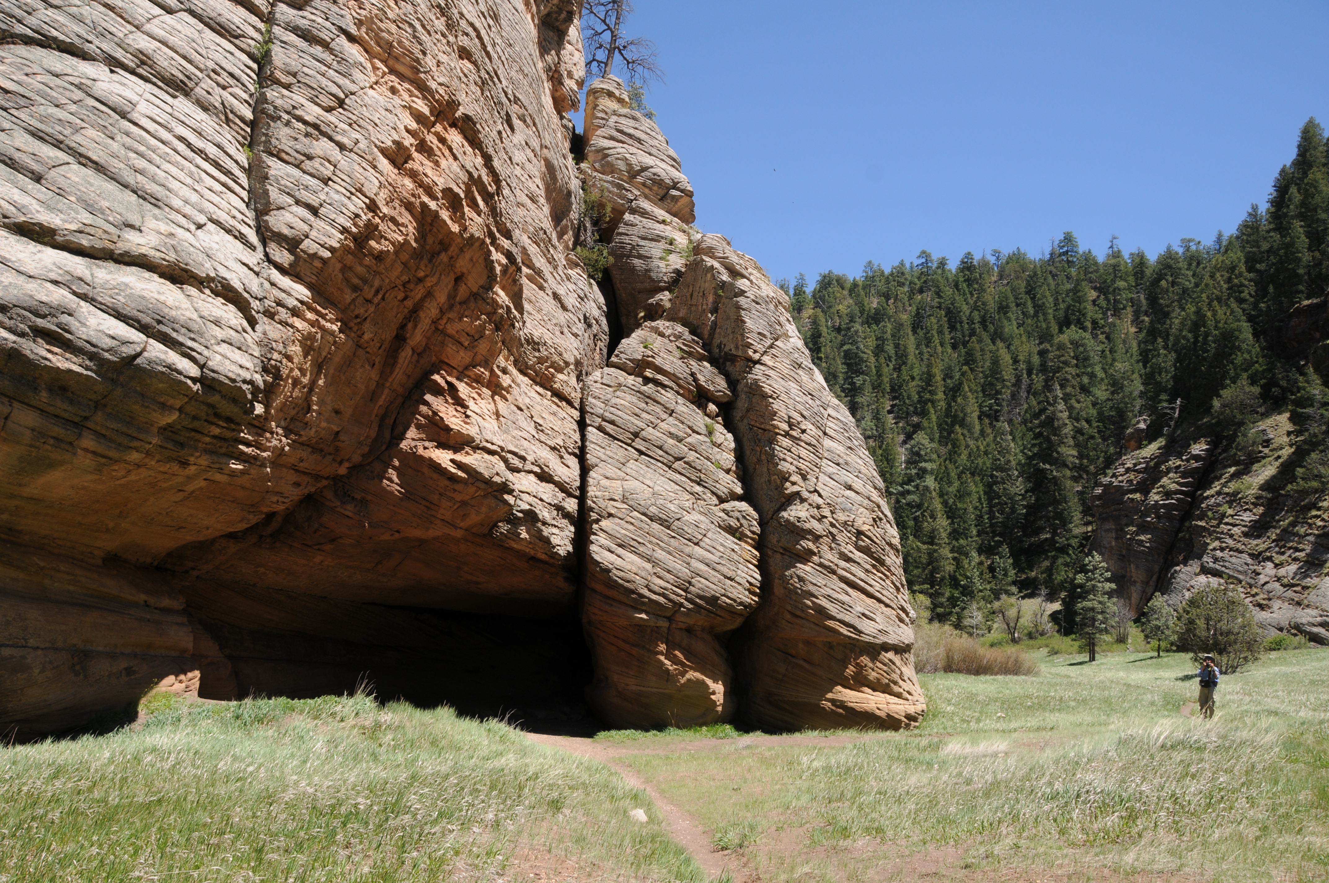
Limestone formations in Sandy's Canyon

Several more minor downhill twists lead to the junction with the Sandy’s Canyon trail. 

Yellow belly pines add olfactory notes to the hike

Here, the Arizona Trail veers right into the canyon where bizarre limestone formations are the key attractions on this very popular forest destination. For those who parked a shuttle vehicle at the Sandy’s Canyon trailhead, veer left at the junction and hike 1.5 miles for a 5.6 mile one-way trek.
Horned lizards are easy to spot on the ArizonaTrail

For a longer hike, Passage 31 continues north to Interstate 40 where it connects with the Elden Mountain Passage on the east side of Flagstaff. The trail also links up with the Flagstaff Urban Trails System and the Flagstaff Loop trail. Consult the Flagstaff city website for details on how to customize a hike circuit. Otherwise, just shit into reverse at the junction for an 8.2-mile out-and-back day hike.

LENGTH:

• 8.2 miles round trip, Marshall Lake trailhead to Sandy's Canyon junction and back.

• 17.9  miles one way for the entire segment.

• 5.6 miles one way for car shuttle.

RATING: moderate

ELEVATION: 6,885 – 7,185 feet as described here (6,500 – 7,185 feet for full passage)

GETTING THERE:

Marshall Lake trailhead:

From Flagstaff go 9 miles south on Lake Mary Road (County Road 3) to Forest Road 128 on the left, signed for Marshall Lake. Continue 2.2 miles on FR 128 (pass the observatory) to the Arizona Trail post at FR 128D, turn left and continue to the parking turnout at the large Arizona Trail sign.

Sandy’s Canyon trailhead:

From Flagstaff,  go 4.5 miles south on Lake Mary Road to the Sandys Canyon Trailhead on the left. Follow Sandy’s Canyon trail 1.5 miles to the Arizona Trail junction on the right.

INFO & MAPS:

Arizona Trail Association

Aztrail.org

Flagstaff Urban Trails System

https://www.flagstaff.az.gov/1379/Flagstaff-Urban-Trails-System-FUTS


Monday, May 15, 2017

WALNUT CANYON TRAIL

WALNUT CANYON TRAIL
Walnut Canyon Trail
Flagstaff’s Walnut Canyon, which splits the landscape southeast of town, is the work of an ancient river that carved its way through dolomite-rich limestone and sandstone.  The geological wonder is rife with history and recreational opportunities. Think prehistoric Sinagua dwellings at Walnut Canyon National Monument, that grueling staircase, hikes along the rim and a scenic passage of the Arizona Trail. As if these attractions weren’t enough, there’s another place tucked into a tributary at the canyon’s western edge that explores its wilder side. To get to this surprisingly green destination, begin on the popular Sandys Canyon Trail, hike two miles through the wide, pine-fringed valley to the equestrian bypass post and veer right heading toward a hub of signs and activity where the Arizona Trail branches into various options for hiking and riding through or around Flagstaff.
Petrified sand dunes on Walnut Canyon Trail
Just around a bend, first glimpses of the petrified sand dunes that characterize the trail stand out in a massive blob of cross-bedded stone. The appearance of the landmark below Fisher Point can be described as having the shape of Star Wars villain Jabba the Hutt and the texture of dinosaur hide. Because Jabba did his dirty deeds a long time ago in a galaxy far, far away we cannot be sure of when he lived, however, we know for sure that Walnut Canyon’s odd geological features are older than the dinosaurs of our own little planet.  The sand dunes formed between 299 and 251 million years ago during the Permian Age when earth’s land masses were coalescing into the super continent of Pangaea. This was a period of climate extremes and harsh conditions.
Cave along Sandys Canyon Trail
This domain of reptiles and other species that would later evolve into mammals ended with a mass extinction of terrestrial and sea species. What happened? Well, theories include climate change due to volcanic eruptions, methane poisoning and asteroid impacts.  Death Star, maybe?
Regardless, the fossil remains of that time form the backbone of a fascinating hike. From the sign post hub, hike over to the “Jabba” formation to explore the cave at its base. At the back of the cavern, look for a slot that lets in a sliver of sunlight.
Cave entry on Walnut Canyon Trail
After checking out the cave, continue east along and unmarked trail to a sign that marks the beginning of the Walnut Canyon Trail. Beyond the sign, the canyon tapers into a tunnel of oaks and willows with an understory of Red-osier dogwood and scratchy brambles. Canyon walls tower 400 feet on both sides as the thin trail plows through damp aspen woodlands, mossy pines and sun-washed meadows.
Jabba the Hutt?
Along the way, two spur paths lead to caves scoured from striated limestone walls. The first is just a shallow overhang while the second is a deep shaft with water seeping from above. Bring a flashlight for this one because it goes back about 25 dark, dank feet. 
The trail goes on to a point roughly 1.8 miles from the Jabba cave where an overgrown drainage and an impenetrable nursery of aspen saplings deny further passage.
Oaks on Walnut Canyon Trail
LENGTH: 8 miles roundtrip
RATING: moderate
ELEVATION: 6820’ – 6580’
GETTING THERE:
From Interstate 17 in Flagstaff, take the Lake Mary Road exit 339 and go 4.5 miles south to the Sandys Canyon Trailhead turnoff on the left.
INFO: Coconino National Forest

Monday, May 20, 2013

To the pit


LE PETIT VERDON
Flagstaff
Rim above Sandy's Canyon and the pit

Let's call this one Sandy's Canyon with a twist.  I happened to be in the area of Mormon Lake last week and decided to make a quick run into the canyon on my way back just to take a peek at the recent  damage from the Fisher Fire. At the trailhead, I got distracted by that pesky sign where Sandy's Canyon/AZ  Trail goes left and Canyon Vista  heads right. As I wasn't really on a schedule, it seemed like to perfect time to make the detour to satisfy my curiosity about the Canyon Vista trail.  As it turns out-- what is an appetizer for hikers is the main course for rock  climbers. Canyon Vista trail dips downhill to Le Petit Verdon---a popular climbing area better known as "the pit".  Here, soaring limestone walls with bolted routes provide dozens of ways to explore the crags in vertical format.  Although it's an enjoyable side trip for hikers, this is the domain of sport climbers, so be respectful when passing near them, or better yet, observe their spiderman-like athletics from a distance.  Once done marveling at the climbers, head back up (and down again) for a trek into Sandy's Canyon.  The fire damage isn't too bad. 

LENGTH: 1 mile roundtrip or 3.8 miles with Sandy's Canyon
RATING: easy (uneven, rocky surfaces)
ELEVATION: 6800' - 6600'
GETTING THERE:
From Phoenix, go north on I17 to just south of I40 in Flagstaff and turn right  onto  exit 339 for Lake Mary Road (FR3).  From the bottom of the off ramp, turn right continue 5.5 miles south to Canyon Vista Campground on the left near milepost 300.  There's a small no-fee parking area  
Climbers in the pit
for hikers.
INFO: Flagstaff Ranger District, Coconino National Forest 928-526-0866
MORE PHOTOS:


Tuesday, April 16, 2013

Fisher Fire is 100% contained.


....close shave.  No word yet as to when Sandy's Canyon Trail will re-open.

From: "Magee, Brienne U -FS" <bmagee@FS.FED.US>
Date: April 16, 2013 3:04:11 PM PDT
To: <USDA-FS-NEWS@NEWSBOX.USDA.GOV>
Subject: SOUTHWESTERN-NEWS-RELEASE: Coconino National Forest
April 16 Update:
The Fisher Fire is 100% contained and 35 acres (slightly smaller size due to more accurate mapping last night). Cause is still under investigation. This was human caused, as there was not any lightning in the area, but specific cause has yet to be determined.

Brienne Magee
Public Affairs Specialist
Flagstaff Ranger District, Coconino NF
5075 N Hwy 89
Flagstaff AZ 86004
o: 928-527-8290

Monday, April 15, 2013

Fisher Fire update

UPDATE: 4-17-2013
Although the Fisher Fire has been declared "100% contained" as of yesterday afternoon, there's still no word as to when the Sandy's Canyon and AZT segment near Fisher Point will be re-opened.  Here's a link to the fire map:
http://azdailysun.com/map-of-fisher-fire/pdf_547c7218-a62e-11e2-bdbe-0019bb2963f4.html

Hikers, because Sandy's Canyon trail is one of my favorites,I've been following this fire very closely and will post forest service press releases as they send them to me.  Looks like fire fighters are making progress.....

Sandy's Canyon: fire was approximately here...

From: "Magee, Brienne U -FS" <bmagee@FS.FED.US>
Date: April 15, 2013 9:15:54 AM PDT
To: <USDA-FS-NEWS@NEWSBOX.USDA.GOV>
Subject: SOUTHWESTERN-NEWS-RELEASE: Coconino National Forest
April 15, 2013

           
Fisher Fire update, 8:30 a.m.

Flagstaff, Ariz. – The Fisher Fire crept and smoldered last night, but did not grow in size. Firefighters have a line around the fire and will continue to strengthen them today. Fire managers want to be sure lines hold through the high winds, however, before they declare an increase in containment.


Size: Approximately 40 acres
Containment: 50%
Location: near Fisher Point approximately four miles south of Flagstaff and two miles northeast of Lake Mary Road and the Canyon Vista Campground.
Date Reported: Saturday, April 13 at approximately 4pm
Cause: Human caused, under investigation
Resources: Approximately 100 personnel including four hotshot crews (Flagstaff Hotshots, Prescott Hotshots, Pleasant Valley Hotshots, and Blue Ridge Hotshots), engines, water tenders, a dozer and several overhead
Closures: The Sandy’s Canyon Trail and Arizona Trail at Fisher Point have been temporarily closed.

Smoke may be visible from the Flagstaff area and will drift to the east; expect smoke to be noticeable in Walnut Canyon, I-40, and the Continental Country Club area.

###

Sunday, April 14, 2013

Fire closes Sandy's Canyon & AZT near Fisher Point

FISHER FIRE UPDATE
Hi Hikers, well, we have our first trail-impacting forest fire of the season.  The human-caused Fisher Fire was reported yesterday.  Here's the forest service press release


Fisher Point

April 14, 2013          
Fisher Fire update, 10:30 a.m.
Flagstaff, Ariz. – The Fisher Fire, south of Flagstaff, burned actively throughout the night. This morning it is approximately 40 acres. Winds are expected to continue today, increasing this afternoon.

Fisher Fire Facts
Date Reported:
Saturday, April 13 at approximately 4pm

Size: Approximately 40 acres

Location: near Fisher Point approximately four miles south of Flagstaff and two miles northeast of Lake Mary Road and the Canyon Vista Campground.

Cause: Human caused, under investigation

Resources: Approximately 80 personnel including three hotshot crews, three engines, two water tenders, a dozer and several overhead

Closures: The Sandy’s Canyon Trail and Arizona Trail at Fisher Point have been temporarily closed.

Smoke will be visible from the Flagstaff area and will drift to the east; expect smoke to be noticeable in Walnut Canyon, I-40, and the Continental Country Club area.
 

###

Tuesday, September 16, 2008

SANDY'S CANYON

On the floor of Sandy's Canyon
the dunes
junction with Arizona Trail
Sandy’s Canyon Trail #87 Coconino National Forest Hidden deep within the walls of a majestic Northern Arizona canyon are an amazing collection of ancient sand dunes that formed in shallow seas more than 250 million years ago. Today, the weathered and cross-bedded limestone heaps with “elephant-skin” veneers stand as bizarre, stone sentinels among the pines in Sandy’s Canyon. Following the southernmost portion of Walnut Canyon --which severs the high plateau country near Flagstaff with a sweeping, fluid gesture--Sandy’s Canyon trail is one of the best ways to explore the gorge and get to the dunes. The pine-shaded first half-mile of the trail skirts the rim of the canyon for outstanding views of the area’s complex geology. The trail then plunges downhill through a forest of mixed conifer and oak. In addition to being home to some of the best “butterscotch pines” around (look for light-colored crackled bark and take a whiff) the rich, moist environment also fosters thickets of delicate Arizona roses, silver puffs and canyon grape. Once through the forest, the trail opens up and meanders through a sunny meadow and continues to the intersection with the Arizona Trail and the official end of the Sandy's Canyon trail.  However, from here,  hiking options abound. Go right to get a close-up look at the dunes and a small wind cave at the base. Past the cave, a primitive path leads into a tributary gorge of Walnut Canyon.  Or, go left on the Arizona Trail and follow it uphill to Fisher Point, a scenic lookout area above the dunes. LENGTH: 2 miles roundtrip on the "official" trail OR 4.8 miles round-trip with the optional trek into Walnut Canyon OR 7.2 miles roundtrip including Fisher Point.  RATING: moderate ELEVATION:6,600'-6,800' (6,600'-7,033' to Fisher Point)    GETTING THERE: From Phoenix travel north on I-17 to the exit 339 for Lake Mary Road (FH 3) located just before the I-17 and I-40 interchange. Go 5.5 miles south on Lake Mary Road to milepost 300, turn left at the sign for  Canyon Vista Campground (just past a cattle guard) and  drive 0.2 mile through the campground  park near the Canyon Vista Trailhead. The signed trail begins at the north end of the parking area. Facilities: restrooms
INFO: Flagstaff Ranger District, Coconino National Forest
http://www.fs.fed.us/r3/coconino/recreation/mormon_lake/sandys-canyon-tr.shtml