


 PIPELINE CANYON TRAIL
Lake Pleasant Regional Park
PIPELINE CANYON TRAIL
Lake Pleasant Regional Park
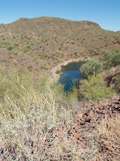
In the desolate desert canyons surrounding Lake Pleasant, the descendents of hardy African beasts roam in happy herds. It’s impossible to know for sure if the area’s wild burros were abandoned or if they escaped from the mining camps that employed them back in the 1800s. Generations removed from their ore-hauling ancestors, the sturdy burros are easy to spot near the coves and inlets along the Pipeline Trail. A cinch to follow, this easy trail begins with a mild descent along a ridge above a quiet estuary. At the bottom of the canyon, cross the floatation bridge and continue hiking among the gigantic saguaros and pungent creosote bushes that populate the rambling hillsides above the lake.
LENGTH: 3.6 miles round-trip
RATING: easy
ELEVATION GAIN: 100 feet
GETTING THERE:
From Phoenix, go north on I-17 to Carefree Highway. Go west (left) on Carefree Highway and continue for 15 miles to Castle Hot Spring Road. Turn north (right) onto Castle Hot Spring Road and continue to the main entrance for Lake Pleasant Regional Park. From there, continue on North Park Road to the south trailhead located near a large water tank just past the turn off for Peninsula Blvd. The unsigned trail begins near the map box to the north of the restrooms.
Fee: There’s a $5 daily fee per vehicle.


 PIPELINE CANYON TRAIL
Lake Pleasant Regional Park
In the desolate desert canyons surrounding Lake Pleasant, the descendents of hardy African beasts roam in happy herds. It’s impossible to know for sure if the area’s wild burros were abandoned or if they escaped from the mining camps that employed them back in the 1800s. Generations removed from their ore-hauling ancestors, the sturdy burros are easy to spot near the coves and inlets along the Pipeline Trail. A cinch to follow, this easy trail begins with a mild descent along a ridge above a quiet estuary. At the bottom of the canyon, cross the floatation bridge and continue hiking among the gigantic saguaros and pungent creosote bushes that populate the rambling hillsides above the lake.
LENGTH: 3.6 miles round-trip
RATING: easy
ELEVATION GAIN: 100 feet
GETTING THERE:
From Phoenix, go north on I-17 to Carefree Highway. Go west (left) on Carefree Highway and continue for 15 miles to Castle Hot Spring Road. Turn north (right) onto Castle Hot Spring Road and continue to the main entrance for Lake Pleasant Regional Park. From there, continue on North Park Road to the south trailhead located near a large water tank just past the turn off for Peninsula Blvd. The unsigned trail begins near the map box to the north of the restrooms.
Fee: There’s a $5 daily fee per vehicle.
PIPELINE CANYON TRAIL
Lake Pleasant Regional Park
In the desolate desert canyons surrounding Lake Pleasant, the descendents of hardy African beasts roam in happy herds. It’s impossible to know for sure if the area’s wild burros were abandoned or if they escaped from the mining camps that employed them back in the 1800s. Generations removed from their ore-hauling ancestors, the sturdy burros are easy to spot near the coves and inlets along the Pipeline Trail. A cinch to follow, this easy trail begins with a mild descent along a ridge above a quiet estuary. At the bottom of the canyon, cross the floatation bridge and continue hiking among the gigantic saguaros and pungent creosote bushes that populate the rambling hillsides above the lake.
LENGTH: 3.6 miles round-trip
RATING: easy
ELEVATION GAIN: 100 feet
GETTING THERE:
From Phoenix, go north on I-17 to Carefree Highway. Go west (left) on Carefree Highway and continue for 15 miles to Castle Hot Spring Road. Turn north (right) onto Castle Hot Spring Road and continue to the main entrance for Lake Pleasant Regional Park. From there, continue on North Park Road to the south trailhead located near a large water tank just past the turn off for Peninsula Blvd. The unsigned trail begins near the map box to the north of the restrooms.
Fee: There’s a $5 daily fee per vehicle.
No comments:
Post a Comment