

 MONUMENT PEAK LOOP
Payson
MONUMENT PEAK LOOP
Payson
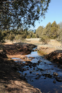
This easy loop trail swings around the base of 5,092-foot Monument Peak—a pyramid-shaped granite monolith in southeast Payson. In my opinion, this hike is the “jewel in the crown” of the Payson Area Trails System (P.A.T.S.)—mostly because of the seasonal stream and the variety of terrain it contains. Kudos to P.A.T.S. for wrangling and weaving a web of old roads and footpaths into a cohesive collection of easy-to-follow trails flanking the suburbs of Payson. A work-in-progress, P.A.T.S. already boasts dozens of miles of finished routes with plans in the works for many more. A key feature of these trails is their accessibility. Trailheads are obvious and the routes are well maintained and marked with abundant signage, so hikers of all skill levels can enjoy carefree walks in the forest.
LENGTH: 3-mile loop
ELEVATION: 4,630’ – 4,795’
RATING: easy
GETTING THERE:
From the intersection of SR87/260 in Payson, go less than a mile east on SR260 to Granite Dells Road (located just past the Safeway center). Turn right and go 3.3 miles on Granite Dells Road (which will turn into FR435 after 1.3 miles) to the parking area on the left. Begin the hike at either the east or west trailhead sign.
BEST SEASONS: all year, but best from October - May
INFO: Payson Area Trails System
http://www.paysonrimcountry.com/MountainRecreation/HikingTrails/PaysonAreaTrailsSystem/MonumentLoopTrail.aspx
MORE PHOTOS: http://www.facebook.com/album.php?aid=51185&id=1795269672&l=8671c8675c


 MONUMENT PEAK LOOP
Payson
This easy loop trail swings around the base of 5,092-foot Monument Peak—a pyramid-shaped granite monolith in southeast Payson. In my opinion, this hike is the “jewel in the crown” of the Payson Area Trails System (P.A.T.S.)—mostly because of the seasonal stream and the variety of terrain it contains. Kudos to P.A.T.S. for wrangling and weaving a web of old roads and footpaths into a cohesive collection of easy-to-follow trails flanking the suburbs of Payson. A work-in-progress, P.A.T.S. already boasts dozens of miles of finished routes with plans in the works for many more. A key feature of these trails is their accessibility. Trailheads are obvious and the routes are well maintained and marked with abundant signage, so hikers of all skill levels can enjoy carefree walks in the forest.
LENGTH: 3-mile loop
ELEVATION: 4,630’ – 4,795’
RATING: easy
GETTING THERE:
From the intersection of SR87/260 in Payson, go less than a mile east on SR260 to Granite Dells Road (located just past the Safeway center). Turn right and go 3.3 miles on Granite Dells Road (which will turn into FR435 after 1.3 miles) to the parking area on the left. Begin the hike at either the east or west trailhead sign.
BEST SEASONS: all year, but best from October - May
INFO: Payson Area Trails System
http://www.paysonrimcountry.com/MountainRecreation/HikingTrails/PaysonAreaTrailsSystem/MonumentLoopTrail.aspx
MORE PHOTOS: http://www.facebook.com/album.php?aid=51185&id=1795269672&l=8671c8675c
MONUMENT PEAK LOOP
Payson
This easy loop trail swings around the base of 5,092-foot Monument Peak—a pyramid-shaped granite monolith in southeast Payson. In my opinion, this hike is the “jewel in the crown” of the Payson Area Trails System (P.A.T.S.)—mostly because of the seasonal stream and the variety of terrain it contains. Kudos to P.A.T.S. for wrangling and weaving a web of old roads and footpaths into a cohesive collection of easy-to-follow trails flanking the suburbs of Payson. A work-in-progress, P.A.T.S. already boasts dozens of miles of finished routes with plans in the works for many more. A key feature of these trails is their accessibility. Trailheads are obvious and the routes are well maintained and marked with abundant signage, so hikers of all skill levels can enjoy carefree walks in the forest.
LENGTH: 3-mile loop
ELEVATION: 4,630’ – 4,795’
RATING: easy
GETTING THERE:
From the intersection of SR87/260 in Payson, go less than a mile east on SR260 to Granite Dells Road (located just past the Safeway center). Turn right and go 3.3 miles on Granite Dells Road (which will turn into FR435 after 1.3 miles) to the parking area on the left. Begin the hike at either the east or west trailhead sign.
BEST SEASONS: all year, but best from October - May
INFO: Payson Area Trails System
http://www.paysonrimcountry.com/MountainRecreation/HikingTrails/PaysonAreaTrailsSystem/MonumentLoopTrail.aspx
MORE PHOTOS: http://www.facebook.com/album.php?aid=51185&id=1795269672&l=8671c8675c
No comments:
Post a Comment