HIEROGLYPHIC CANYON
Superstition Wilderness

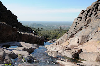
Not too many years ago, getting to Hieroglyphic Canyon in the Superstition Wilderness Area required some effort. A long approach, unclear route and an ever-encroaching quagmire of private property and access restrictions precluded all but the most robust and determined hikers from visiting the canyon and its treasure trove of ancient Hohokam rock art. Recently, the Superstition Area Land Trust (S.A.L.T.) and Pinal County worked together to make Hieroglyhic Canyon more accessible. Through their efforts, a developed trailhead and parking area sprung up where once only limited roadside pullouts served as parking spots. There’s even a porta potty now. At first blush, this was a wonderful accomplishment. These improvements opened up the area to thousands who would otherwise miss the opportunity to learn from and enjoy this national treasure. However, among the trail’s smartly designed informational signage, there’s not a word about the irreplaceable historical significance of the rock art. Archeologists believe the petroglyphs range in age from 2,000 to 200 years old. Images of animals, plants, humans and mysterious geometric designs pecked into the rock veneer give a rare and precious glimpse into the life and culture of Arizona’s native inhabitants. The glyphs are scattered across a segment of the canyon where water runs over stone terraces nearly year-round. It’s a beautiful sight to behold—natural, open and entirely exposed to vandalism and damage from careless visitors. We visited this area early in the morning of February 21, 2009 and arrived at the petroglyph site around 8:30 a.m. By 9:30, the canyon had become overrun with visitors, many of whom proceeded to demonstrate an absolute disregard for historic preservation by climbing on (ON, not around) the artifacts. Young children were allowed to ply the ancient etchings with peanut butter encrusted fingers while cell phone wielding teens teetered atop an elegant set of animal drawings, chattering like baboons as the soles of their shoes chafed the delicate art. Granted, much of this behavior may be happening because people simply do not understand the rock art’s significance and fragility. In fact, while we were there, we conducted an informal query of the perpetrators and found that some of them had no idea the petroglyphs were “real”. Because of all the interspersed modern graffiti, one man assumed that all of the markings were the work of latter-day hoodlums. As the canyon swelled with droves of careless explorers, I struggled with a churning mix of anger, sadness and an urge to scream “get off the friggin petroglyphs!” Instead of making an ass out of myself, I wrote this diatribe—which makes me feel better, but does little to solve problem. You can help by educating your friends, families and co-workers about historical site preservation. Send them the link to this blog posting and the link to the Archeological Site Etiquette Guide shown below. Also, feel free to pester the following agencies at will.
LENGTH: 3 miles round trip
RATING: easy
ELEVATION: 2,050-' 2,620'
GETTING THERE:
From Phoenix, take US 60 east to Apache Junction. Between milesposts 202 and 203, turn left onto Kings Ranch Road and go 2.8 miles to Baseline Road. Turn right and follow Baseline 0.3 mile to Mohican, turn left, go 0.3 miles to Valley View. Turn left and follow Valley View (turns into Whitetail Road) to Cloudview Ave, turn right and continue 0.5 mile to the trailhead.
INFO: Tonto National Forest
http://www.fs.usda.gov/recarea/tonto/recreation/hiking/recarea/?recid=35483&actid=50
Archeological Site Etiquette Guide: http://azstateparks.com/SHPO/etiquette.html
Superstition Area Land Trust (S.A.L.T.) http://www.azsalt.org/ Arizona Archeological Society http://www.azarchsoc.org/phoenixchapter.html


 Posts
Posts


 When the wonderfully thick pine-fir woodlands of Barnhardt Canyon went up in flames, the devastation was already a few hundred years overdue. Yet, the fact that naturally-occurring forest fires are as inevitable as they are necessary for forest health, did little to keep my heart from aching that summer in 2005 when I kept watch on the plumes of smoke over the Mazatzal Mountains from my Scottsdale office as they made an agonizingly slow beeline toward Barnhardt Canyon. Fires of this nature happen every few hundred years, and it has been estimated that more than 500 years had passed since Barnhardt Canyon last took the heat. The day the fire swept up the canyon, the abundant fuels sent billowy white towers of smoke higher than on any other day of the month-long blaze. Mental images of smoldering trees and eroding slopes haunted me for days.
In March of the following year, we decided to hike the Barnhardt trail to see the damage for ourselves. The drive in to the trailhead showed minimal fire damage and the parking area was completely intact---surrounded by healthy junipers and scrub oaks. A collective sigh and an “it’s not so bad afterall” attitude stayed with us for less than a mile of hiking. Fire is arbitrary in its path and fickle in choosing victims. The pattern of destruction in the canyon seems to make little sense. In places, acres of 100-foot-tall black matchsticks clung to the ravines, still smelling of smoke while random patches of oaks stood untouched. One striking sight was a lone agave—the sole survivor living in an alcove of soot and ash. Gone was the majestic grove of Ponderosa pines that shaded a stony side canyon where snowmelt tumbled downhill. The oak and manzanita hedges that lined a section of trail over a 1,000-foot drop off—gone. It seemed that the damage increased with the elevation. Our normally gregarious hiking group went silent when we rounded the bend past the upper falls. Here, the damage was absolute. Where a sea of manzanitas and scrub oaks had once dominated the landscape there was now nothing but dirt and ash. Save for the blackened remains of an old wooden junction sign placed on a charred tree stump, our beloved trail had been obliterated.
Since the fire, we’ve been going back to Barnhardt every year. The trail has been restored and many of the burnt trees have toppled to the ground and are rapidly turning to dust. Vegetation is coming back strong, and this year, we even had a nice showing of wildflowers. With many of the trees gone, views of the areas complex geology have opened up and the trail has taken on a new flavor. Although it will be hundreds of years before the forests regenerate, the signs of recovery are encouraging. Until then, random, fickle things, like the sprouts that emerged from the lone survivor agave this spring, keep us entertained. Happy trails, Mare SEE MY 2010 ENTRY FOR A VIDEO OF THE UPPER WATERFALL.
See prior entry for trail information.
When the wonderfully thick pine-fir woodlands of Barnhardt Canyon went up in flames, the devastation was already a few hundred years overdue. Yet, the fact that naturally-occurring forest fires are as inevitable as they are necessary for forest health, did little to keep my heart from aching that summer in 2005 when I kept watch on the plumes of smoke over the Mazatzal Mountains from my Scottsdale office as they made an agonizingly slow beeline toward Barnhardt Canyon. Fires of this nature happen every few hundred years, and it has been estimated that more than 500 years had passed since Barnhardt Canyon last took the heat. The day the fire swept up the canyon, the abundant fuels sent billowy white towers of smoke higher than on any other day of the month-long blaze. Mental images of smoldering trees and eroding slopes haunted me for days.
In March of the following year, we decided to hike the Barnhardt trail to see the damage for ourselves. The drive in to the trailhead showed minimal fire damage and the parking area was completely intact---surrounded by healthy junipers and scrub oaks. A collective sigh and an “it’s not so bad afterall” attitude stayed with us for less than a mile of hiking. Fire is arbitrary in its path and fickle in choosing victims. The pattern of destruction in the canyon seems to make little sense. In places, acres of 100-foot-tall black matchsticks clung to the ravines, still smelling of smoke while random patches of oaks stood untouched. One striking sight was a lone agave—the sole survivor living in an alcove of soot and ash. Gone was the majestic grove of Ponderosa pines that shaded a stony side canyon where snowmelt tumbled downhill. The oak and manzanita hedges that lined a section of trail over a 1,000-foot drop off—gone. It seemed that the damage increased with the elevation. Our normally gregarious hiking group went silent when we rounded the bend past the upper falls. Here, the damage was absolute. Where a sea of manzanitas and scrub oaks had once dominated the landscape there was now nothing but dirt and ash. Save for the blackened remains of an old wooden junction sign placed on a charred tree stump, our beloved trail had been obliterated.
Since the fire, we’ve been going back to Barnhardt every year. The trail has been restored and many of the burnt trees have toppled to the ground and are rapidly turning to dust. Vegetation is coming back strong, and this year, we even had a nice showing of wildflowers. With many of the trees gone, views of the areas complex geology have opened up and the trail has taken on a new flavor. Although it will be hundreds of years before the forests regenerate, the signs of recovery are encouraging. Until then, random, fickle things, like the sprouts that emerged from the lone survivor agave this spring, keep us entertained. Happy trails, Mare SEE MY 2010 ENTRY FOR A VIDEO OF THE UPPER WATERFALL.
See prior entry for trail information.


