Find A Trail. Start Your Search Here:

Monday, July 18, 2022

Arizona Trail: Passage 31

ARIZONA NATIONAL SCENIC TRAIL: WALNUT CANYON PASSAGE 31

Gate on Passage 31 of the Arizona Trail

Shady and cool, Passage 31 of the Arizona National Scenic Trail is a satisfying respite from summer heat.  The 17.9-mile segment of the 800+-mile, state traversing route

drops off the plateau lakes region of Anderson Mesa and heads into pine-oak woodlands in Coconino National Forest southeast of Flagstaff.  Also known as the Walnut Canyon passage for its swing by the finger canyons and periphery of Walnut Canyon National Monument, this close-to-town segment of trail has several access points that make it perfect for day hikes, loop and car shuttle options. One trip to try goes from Marshall Lake to Sandy’s Canyon.

Greenery around Marshall Lake Tank

At the Marshall Lake trailhead, hikers get a reality check on the effects of drought.  While Marshall Lake is rarely more than a shallow, reed-choaked pond, this year, it’s bone dry.  Still, its elongated, pine-wrapped footprint is a picturesque sight and favorite grazing territory for elk.

Mountain vistas are meager, trees are major

The hike heads north from the large Arizona Trail sign along a well-defined and maintained singletrack.

Sign at Marshall Lake trailhead

 
Thick tree coverage and riffled terrain obscure big vistas, so this hike is more about immersing in the details of forest life. 
There are many ways to extend this Flagstaff hike

It’s a great place to smell “yellow belly” pines--older Ponderosa pine trees that have developed yellow-brown bark scales and emit a syrupy fragrance that’s often described as butterscotch, vanilla or cardamon. 
Marshall Lake was dry, July 2022

Each tree has a unique olfactory signature that blooms when warmed by the sun. 
Winged buckwheat blooms July - September

Go ahead and take a whiff, but be respectful. There’s no need to damage the bark to determine if the sap is sweet, savory or spicy.  
Hike may be extended into Sandy's Canyon


About 1.5 miles in, the green swale behind Marshall Mesa Tank appears below a set of easy switchbacks that lead into a shallow ravine.  The wildlife water hole is contained by an earthen dam, but, like the lake, it was dry, but lingering moisture feeds a fringe of wildflowers and elderberry trees.
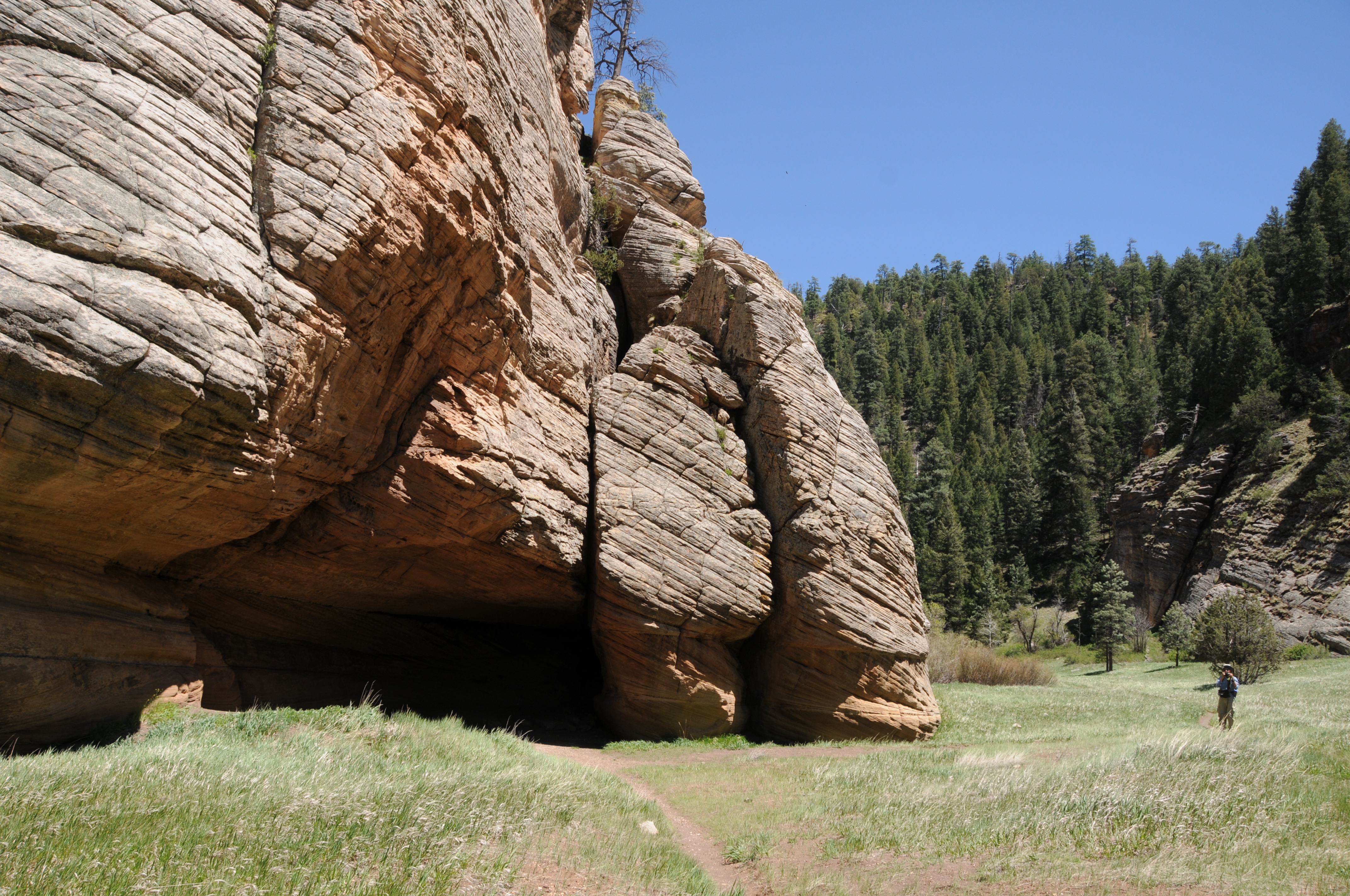
Limestone formations in Sandy's Canyon

Several more minor downhill twists lead to the junction with the Sandy’s Canyon trail. 

Yellow belly pines add olfactory notes to the hike

Here, the Arizona Trail veers right into the canyon where bizarre limestone formations are the key attractions on this very popular forest destination. For those who parked a shuttle vehicle at the Sandy’s Canyon trailhead, veer left at the junction and hike 1.5 miles for a 5.6 mile one-way trek.
Horned lizards are easy to spot on the ArizonaTrail

For a longer hike, Passage 31 continues north to Interstate 40 where it connects with the Elden Mountain Passage on the east side of Flagstaff. The trail also links up with the Flagstaff Urban Trails System and the Flagstaff Loop trail. Consult the Flagstaff city website for details on how to customize a hike circuit. Otherwise, just shit into reverse at the junction for an 8.2-mile out-and-back day hike.

LENGTH:

• 8.2 miles round trip, Marshall Lake trailhead to Sandy's Canyon junction and back.

• 17.9  miles one way for the entire segment.

• 5.6 miles one way for car shuttle.

RATING: moderate

ELEVATION: 6,885 – 7,185 feet as described here (6,500 – 7,185 feet for full passage)

GETTING THERE:

Marshall Lake trailhead:

From Flagstaff go 9 miles south on Lake Mary Road (County Road 3) to Forest Road 128 on the left, signed for Marshall Lake. Continue 2.2 miles on FR 128 (pass the observatory) to the Arizona Trail post at FR 128D, turn left and continue to the parking turnout at the large Arizona Trail sign.

Sandy’s Canyon trailhead:

From Flagstaff,  go 4.5 miles south on Lake Mary Road to the Sandys Canyon Trailhead on the left. Follow Sandy’s Canyon trail 1.5 miles to the Arizona Trail junction on the right.

INFO & MAPS:

Arizona Trail Association

Aztrail.org

Flagstaff Urban Trails System

https://www.flagstaff.az.gov/1379/Flagstaff-Urban-Trails-System-FUTS


Monday, July 11, 2022

Bill Back Park

BILL BACK PARK

Sunny meadow of Bill Back Park

No crowds, no water, no restrooms, no trash service, no picnic tables, no fees--no problem. That’s the deal with dispersed camping, a way of lodging in the forest outside of developed campgrounds.
Golden-beard penstemon bloom June - October

Camping styles at these no-frills dirt pullouts range from primitive bivouacs, group tent cities (Barbie forts, anybody?) to luxury RV setups complete with full kitchens and satellite television. Which kind of makes you wonder, no?

Forest Road 230 serves as the trail

Whatever the interpretation of “sleeping rough”, dispersed camping requires a higher degree of preparedness as well as attention to proper sanitary procedures, trash removal and campfire safety including knowing when fires are banned. 

A tiny waterhole attracts wildlife

Summertime in Arizona means forest roads are lined with pop-up temporary living quarters.  

While many of these no-star waystations are located steps away from popular hiking trails like the Arizona National Scenic Trail, others are not.

Alfalfa blooms April - October

So in between dipping into the beer cooler and flipping through tawdry novels, a good way to break up the time on the off-the-beaten track tracks is to take a walk on dirt roads to soak in the beauty of the forest and spy the details that are easy to miss while lurching along in a motor vehicle.
Woodland pinedrops bloom June- Sept

The Coconino National Forest Motor Vehicle Use Map, which is available for free in hard copy, downloadable pdf or digital format, shows where dispersed camping is allowed. 

Lupine is a common summer bloomer

No-frills dispersed campsites offer solitude

One shady, high elevation place to try is the roads around Bill Back Park south of Flagstaff and Mormon Lake.
Delicate American vetch bloom May - Sept

Less than a half-mile from paved Lake Mary Road, Forest Road 230 not only offers dozens of generously spaced campsites, but also makes for easy summer strolling under tall pines. Beginning at the junction of Stoneman Lake Road (FR213) the hike down FR 230 begins in sunny meadows before ducking into Ponderosa pine woodlands. The outwardly monodominant forest of soaring conifers belies a much richer ecological diversity that’s easily exposed to those with an inclination for discovery.

Rustic corral along a side road

Roadside pops of color, courtesy of lupine, penstemons, clover, thistle and blooming shrubs, brighten meadows while tiny waterholes harbor mini wetland environs rife with water buttercups, frogs and elk.
Yellow sweet clover blooms June- August

 
Bill Back Park, a long, open pasture fringed with pines attracts swarms of birds and critters.  At the south end of the park, Forest Road 230G spins off to the left. 
Common silverweed grows in moist areas May - August

A few yards down this non-motorized spur path, a wood-and-barbed wire corral falls apart in plain view.  Beyond the corral, the road descends through the heavily forested divide between 7,743-foot Bill Back Butte and 7,639-foot Jackson Butte.
Western Blue Flax blooms April - September

FR230 passes between Bill Back and Jackson buttes

Gamble oaks and wild roses enter the botanical mix before the road meets a cattle guard at the 3.85-mile point.
Horned spurge shrubs bloom April - August

 
 This makes for a good turnaround point in order to get back to camp for a frosty IPA in isolated, pine-swaddled bliss.  

LENGTH: 7.7 miles roundtrip

RATING: easy

ELEVATION:  7,231 – 7,406 feet

GETTING THERE:

From Flagstaff, go 34.2 miles south on Lake Mary Road (Country Road 3) to Stoneman Lake Road (Forest Road 213). Turn left and continue 0.4 mile to Forest Road 230 on the left.  Park in any of the dirt turnoffs along the road.

Coconino National Forest Motor Vehicle Use Map

https://www.fs.usda.gov/detail/coconino/landmanagement/projects/?cid=stelprdb5356224


Monday, June 27, 2022

Willow Crossing

WILLOW CROSSING

The limestone arch in Willow Valley

Tucked into a sliver of space in the canyon-addled watershed of West Clear Creek, Willow Valley is a calm oasis of green in an water-carved landscape.  Within the shallow canyon, a sketchy trail known as Willow Crossing descends from an airy plateau littered with toppled trees from past wildfires, wildflower meadows and a smattering of tall pines into a narrow canyon with a totally different character. 

Inside the riparian zone of Willow Valley

Bound by chalky limestone walls chiseled into layer-cake-like formations, the ecozone inside the mini, Mogollon Rim gorge transforms from a sunny, lightly-wooded mesa into a jungle of greenery. 
The rim above Willow Valley in Coconino National Forest

This tiny Eden isn’t easy to find or follow, but careful explorers are rewarded with many surprises. A series of rough dirt back roads near Clints Well in Coconino National Forest northeast of West Clear Creek Wilderness, lead to a barely-there trailhead. To pick up the historic route, follow the old barbed wire fence to a gate near the edge of the canyon. Pass the gate (close it behind you) and pick up the obvious path leading downhill.
Riparian vegetation in Willow Valley

As the short, rocky trail descends among hairy stands of common mullein that can sprout corn-like shoots to over 6 feet high, riparian vegetation closes in on the trail.
Common mullein grows on the canyon rim

Willow Valley is in the watershed of West Clear Creek

Gamble oaks, boxelder, New Mexico locust and a tangle of the eponymous willow trees clutter the slopes. Where the trail bottoms out at a drainage, look for water-loving wildflowers and shrubs like larkspur, wild roses and red-osier dogwood. 
Larkspur colors the trail in summer.

Like all “crossing” trails on the Rim, this one hops the drainage and heads up to the opposite lip of the canyon. In between the rims, the hike’s signature attraction stands nearly obscured by tree cover and wild grape vines woven among thickets and boulders.
Red-osier dogwood grows in the drainage area

A delicate natural arch carved from the canyon’s sedimentary rock walls forms a fragile bridge over a fold in the disintegrating wall revealing a glimpse of sky and Ponderosa pines 400 feet above.

LENGTH: 2-3  miles round trip

RATING: moderate

ELEVATION: 6,400 – 6,800 feet

GETTING THERE:

From Payson, go north on State Route 87 to Lake Mary Road (County Road 3) turn left and go north on CR3 to Forest Road 81 at milepost 297.7. Turn left and continue 3.1 miles to Forest Road 81E. Set your odometer, and go left on FR 81E 1.14 miles to Forest Road 9366M—an easy-to-miss, unmarked dirt road on the left. Go 0.5 miles on FR 9366M to a cattle guard and gate. The trailhead is just past the gate on the left near the generic “trail” sign and rock cairns. A high clearance vehicle is recommended on the forest roads.

INFO:

Coconino National Forest

https://www.fs.usda.gov/recarea/coconino/recarea/?recid=55052


Wednesday, June 22, 2022

Keyhole Sink

KEYHOLE SINK

Keyhole Sink surrounds a moist seep area

Not too far off Old Route 66 a few miles east of the town of Williams, a cloistered box canyon with vertical stone walls encircles a depression where water sometimes cascades over the cliffs and pool at the base of the pine-shaded oasis. 

The woodsy approach to Keyhole Sink

The sounds of tree frogs, birds, and scampering squirrels bite through a soundtrack of wind rustling through aspen canopies.  The moist, cool place vibrates with a life essence that transcends the moment.  It’s like walking through a sort of time capsule set on perennial-fill mode.
A petroglyph panel at Keyhole Sink

The Kaibab National Forest site’s ample forage grasses, water and quiet isolation made this a perfect spot for wildlife to congregate, feed, drink, and--oh yeah--be stalked.  

Aspen saplings on the Keyhole Sink Interpretive trail

From roughly 1,000 years ago, ancestral Native American hunters documented their experiences at this enchanting hideaway by pecking images of deer, bear and other local wildlife into the folds and panels of cliff faces that are the weathered remains of ancient lava flows.   Today, hundreds of the images are visible on the volcanic escarpments.
Keyhole Sink is a wildlife oasis

Dense galleries depict a vibrant, and resource-rich environment.  While the meaning and utility of the petroglyphs is best known to the makers, present day viewers may immerse in the pure beauty of the etchings and extrapolate the notes of celebrations, observations, and maybe just the plein air sketches they may have depicted.  Regardless, it’s clear that Keyhole Sink remains a living, breathing microcosm of life in the forest. 
Visitors must be front-line protectors of this heritage site

A short, interpretive trail and a descriptive brochure available online, guide visitors through the woodsy outdoor classroom.

Sadly, there’s a history of vandals defacing the rock art. Restoration involves hundreds of volunteer hours, thousands of dollars, and years of work with no guarantees of fully rehabilitating the artfacts.  Why this happens in a place that is sacred to modern Native American tribes is beyond comprehension. The place is not a “ruin”, it’s an ancestral homeland.

Although Keyhole Sink is monitored by Arizona site stewards, visitors must be the front-line protectors. As with all heritage sites, respect the irreplaceable artifacts. Do not touch or otherwise alter the rock art, stay on designated trails, pack out all trash, and leave what you find so that future generations may appreciate this Arizona point-of-pride.

LENGTH: 2 miles round-trip

RATING: easy

ELEVATION: 7,100 – 7,000 feet

GETTIGN THERE: From Flagstaff, go 16 miles west on Interstate 40 to the Parks exit 178. Connect with Historic Route 66 and go 4 miles west (left) to the Oak Hill Snow Play Area on the left. The trailhead is located across the road from the parking lot at a signed gate.

INFO:

Kaibab National Forest

https://www.fs.usda.gov/recarea/kaibab/recarea/?recid=11678


Friday, June 17, 2022

Coconino National Forest Proposed Fee Changes 2022

 Coconino NF seeks public comments on proposed fee changes at six recreation sites


Site Name

Current Fee

Proposed Fee

Bell Trail

None

$5

Bruce Brockett Trail

None

$5

Dry Creek Trail

None

$5

Fay Canyon Trail

None

$5

Lava River Cave

None

$5

Mescal Trail

None

$5

SEDONA, Ariz., June 13, 2022 – The Coconino National Forest is seeking public input on proposed fee implementation at six specific high-use recreation sites to provide consistent maintenance and keep these sites and trails at a level of quality visitors have come to expect.


Numerous day-use sites, overnight camping sites, and other recreation sites are managed without user fees across Coconino National Forest. The following day-use sites would be added to the current Red Rock Pass Fee Program, and the Interagency America the Beautiful Passes will also be honored at these sites.

The public comment period begins today. To ensure that your comments are considered, please send your comments to the Coconino National Forest no later than August 31, 2022 using one of the following methods:

  • Mail: Address to Coconino NF, Red Rock Ranger District, Attn: Chris Johansen, P.O. Box 20429, Sedona, AZ 86341-0429

  • Online: Go to www.fs.usda.gov/goto/r3/SusRec and utilize a public comment mapping tool to comment on specific sites or to make a general comment on fee proposals.


  • In person: Oral comments must be provided to Christopher Johansen during normal business hours (Monday – Friday, 9 a.m. – 4:00 p.m.) or by calling (928) 203-7529 and indicating you would like to provide comments on the proposed recreation fee changes.


Once public involvement is complete, the proposed fee changes will be reviewed by the Recreation Resource Advisory Committee (RAC) during their winter 2022 meeting. If the RAC and the Regional Forester approve of the changes, fees could be implemented at these sites as early as spring 2023.


In 2004, Congress passed the Federal Lands Recreation Enhancement Act (REA) which allows the Forest Service to retain funds collected at certain recreation sites and use these funds locally to operate, maintain, and improve these sites.


These additional funds along with 95% of the revenue from recreation fees remain on the national forest to operate, maintain, and improve facilities. The resource derived through collection of fees helps provide quality recreation opportunities that meet the modern expectations of visitors and creates a more financial sustainable developed recreation program for the benefit of future generations.


Under REA, all new fees and any fee changes must be proposed and approved by a citizen’s advisory committee, Arizona Bureau of Land Management Resource Advisory Committee. Committee members represent a broad array of recreation interest groups to help ensure that the Forest Service is proposing reasonable and publicly acceptable new fees and fee changes.

Wednesday, June 15, 2022

Forest Closures 2022

FOREST CLOSURES 2022

Hiking vicariously thru oil painting. Escudilla Mountain

Tinder box dryness, wildfires and dry lightning season combine for extremely dangerous conditions in Arizona.  About this time each year, land managers begin implementing State 3 Fire Restrictions which include FULL FOREST CLOSURES.   

Please check before heading out and RESPECT ALL CLOSURES & RESTRICTIONS. 

I'll be staying local for the next few weeks, hiking in the early morning and hiking vicariously by indulging in my hobby of making oil paintings of some of my favorite national forest hiking trails.

Here's a list of websites to check current restrictions:


COCONINO NATIONAL FOREST

https://www.fs.usda.gov/coconino/


KAIBAB NATIONAL FOREST

https://www.fs.usda.gov/kaibab


APACHE-SITGREAVES NATIONAL FOREST

https://www.fs.usda.gov/asnf


TONTO NATIONAL FOREST

https://www.fs.usda.gov/tonto


CORONADO NATIONAL FOREST

https://www.fs.usda.gov/coronado


PRESCOTT NATIONAL FOREST

https://www.fs.usda.gov/prescott/


WILDFIRE INFORMATION

https://inciweb.nwcg.gov/

Monday, May 23, 2022

Upper Lake Mary

UPPER LAKE MARY

Mormon Mountains stand out over Upper Lake Mary

At the tail end of the twin reservoirs of Upper and Lower Lake Mary, an airy draw closes in on the murky meanders of Walnut Creek. 

Upper Lake Mary viewed from FR 9485C

Cutting through dry stubble and emergent grasses, the entrenched creek course snakes south through coniferous woodlands in Coconino National Forest.
Rocky Mountain iris bloom May - September

Earthen dams on the creek contain the elongated lakes that are a major source of water for the City of Flagstaff roughly 15 miles to the north.

Log pole fence on the shore of Upper Lake Mary

 While the lower lake is usually bone dry, Upper Lake Mary retains enough water for boating, water skiing, fishing, and picnicking. Nearby camping and access to the Arizona National Scenic Trail, make the lakes a popular recreational destination. 
Drought has altered the landscape around the lake

Water levels vary depending on rain and snowmelt.  According to the USGS, Upper Lake Mary is about 5.6 miles long with a surface area of 939 acres and a maximum depth of 39 feet when at full capacity. Prolonged drought has altered the lake’s size and character.
Field bindweed bloom May - September

Deepest near the dam at its north end, Upper Lake Mary shallows out as it bends southward gradually morphing into puddles, mucky swales, and a dry draw where the ghost of the creek exists in deeply incised, twisted channels.
Butter & eggs bloom May - September

A short forest road on the east shore provides a close look at this transitional segment where the lake goes from pond to puddle to pasture in just under one mile.  Forest Road 9485C serves as the trail for the 2-mile round trip hike. 
San Francisco Peaks on the horizon

Wide, rocky, and relatively flat, the dirt two-track sits just below Lake Mary Road. 
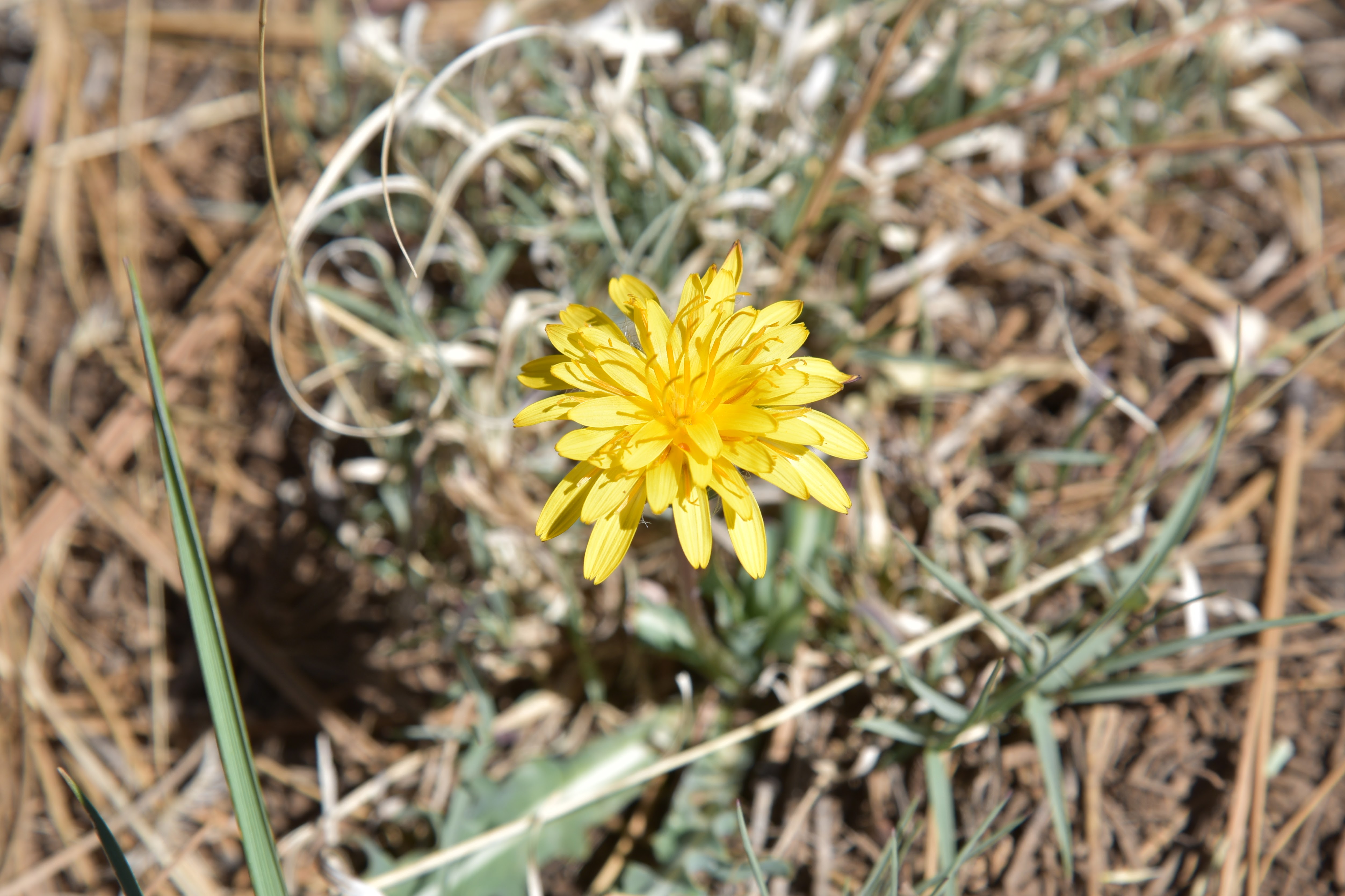
Mountain dandelion bloom May - October

Over the first-quarter mile, Ponderosa pine trees stand over the last sizable reaches of lake water where Great blue herons, waterfowl and—for early morning hikers—elk, might be spotted browsing the weedy fringes.
Hike uses FR 9485C below Lake Mary Road

The rounded peaks of Mormon Mountain stand out over an ever-fading spillway to the south.  About where a rustic pole fence stands at what appears to be the former edge of the lake, water sightings are replaced by juniper-framed views of the creek meanders and glimpses of the San Francisco Peaks to the north. 
Creek meanders at the far south end of Upper Lake Mary

While drought has altered the landscape, there’s still a thriving understory of blooming shrubs and wildflowers. Sunflowers put on an especially gorgeous show in late summer, blanketing the shores in acres of brilliant yellow.

LENGTH: 2 miles round trip

RATING: easy

ELEVATION: 6,830 – 6,850 feet

GETTING THERE:

From Flagstaff, travel  15.5 miles south on Lake Mary Road (County Road 3) to Forest Road 9485C on the right past milepost 329. There are no fees at this day use parking area.