Find A Trail. Start Your Search Here:

Monday, February 24, 2020

Lousley Hill Trail

LOUSLEY HILL: McDowell Mountain Regional Park.
A hiker and his dog look out over the Verde River Valley
Finding a quiet place in McDowell Mountain Regional Park in Fountain Hills isn’t always easy.
With its long, flowing trails the 21,099-acre Maricopa County park in Fountain Hills is popular with mountain bikers, hikers and equestrians.
A rock stack marks the summit of Lousley Hill
Outfitted with camp sites, picnic areas, playgrounds and family-friend amenities and events, the park is a very busy place in Arizona’s cooler months. Still, solitude can be found, if you know where to look.
The area is recovering from a 1996 wildfire
The 1.2-mile Lousley Hill Trail is an under-the-radar gem that’s perfect for escaping the crowds.  The quiet trail offers easy access, a mild climb and scenic vistas of the Verde River Valley, McDowell Mountains and distant wilderness peaks. From the trailhead, a short access path crosses a sandy wash shaded by a mesquite trees to connect with the loop portion of the trail. Either leg of the loop works for the climbing part although the left leg is less steep and more gradual that the right.
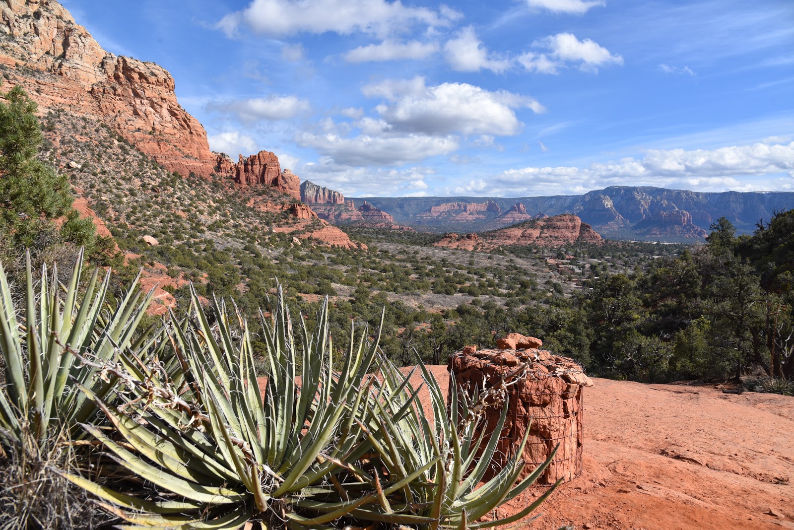
The trail makes a moderate climb with great views all around
The trail hugs the exposed, brittlebush-covered slopes of a peak on the northern nub of the Lousley Hills, a north-south running ridge at the park’s east border.  The path is well-maintained but a little rocky. There are rest areas with benches on both legs of the loop to take a break if needed.
A lightening-cause fire in 1996 destroyed much of the park’s vegetation. Except for a few telltale black scars on saguaros, disintegrating tree skeletons and sparse tree cover, you’d never know that 14 years ago, the area looked like an ashen moonscape.
Lousley Hill Trail sports lush spring wildflowers
Since then, the scorched earth has given way to a resurgence of desert shrubs, trees and wildflowers. This is an especially pretty hike in spring when Mexican gold poppies color the foothills and surrounding plains.  Scattered stands of Palo verde trees and saguaro cacti provide spots of shade throughout the otherwise open-to-the-sky hike.  A series of long, lazy switchbacks land hikers on the tiny summit. A gigantic rock cairn sits at the top of the sunny vantage point with 360-degree views. 
Rugged terrain & mountain peaks seen from Lousley Hill Trail
Look for the distinctive knob of Red Mountain rising above emerald flood plains at the convergence of the Salt and Verde Rivers and the and hazy silhouettes of the Sierra Ancha mountain range. 
The trail's moderate grade is perfect for kids and dogs
The summit has plenty of nice spots to take a break or hang out to enjoy the solitude of an isolated desert bluff. If you’re up for more following this mini mountain assault, consult the park map to build a longer loop or out-and-back hike.
LENGTH: 1.2-mile loop
RATING: moderate
ELEVATION: 1,711 – 2,036 feet
GETTING THERE:
16300 McDowell Mountain Regional Park Dr., Fountain Hills.
From the park entry gate, follow McDowell Mountain Park Road past the main trailhead staging area to the Lousley Hill trailhead on the right. There’s a restroom nearby.
FEE: There’s a $7 daily fee per vehicle.


Tuesday, February 4, 2020

Ryal Canyon Trail

RYAL CANYON: Prescott National Forest
High desert vegetation lines the Ryal Canyon Trail 
Up until last year, gaining access to one of the most challenging hikes in the Camp Verde area was an iffy venture. Although the Ryal Canyon Trail 521 terminus is located right off Salt Mine Road just a few miles southeast of town, hikers had to cross private property to get to it.  The landowner was pretty chill about allowing people to walk the few yards between the road and the Prescott National Forest boundary where the trail begins, but the town of Camp Verde decided to do the right thing and make access to the popular multi-use trail legal.
Fractured earth and white cliffs on Ryal Canyon Trail
With a grant provided by Arizona State Parks and Trails and the Off-Highway Vehicle Recreation Fund, the city purchased a 4.4 acre buffer zone from the privately-owned Salt Mine Cattle Company. 
The hike begins at the boundary of Prescott National Forest
The purchase and subsequent development of a real trailhead are part of a larger effort to expand trail access and stoke interest in hiking in the Camp Verde area.
The roomy new trailhead has plenty of parking and provides worry-free access to trail 521. At this writing, the trailhead is open but still under construction. Trail signs and other planned amenities including a restroom and picnic ramadas have yet to be installed.  But the drive-up convenience doesn’t mean the rugged trail that’s known for its fierce workout value has been tamed. To find the route, just pass through the forest boundary gate and start hiking on the dirt two track that parallels a deeply rutted drainage area where hardy mesquite trees teeter over gaping cracks in the flat terrain.
The trail skirts the crest of Ryal Canyon
It takes about 10 minutes of walking to discover that this hike is not for the faint of heart.
Steep and rocky, the 2.5-mile path also has some sections that cling uncomfortably close to the precipitous edges.  The trail swings south, hugging the crest of Ryal Canyon via a series of aggressive vertical clambers with intermittent level sections. 
Ryal Canyon trailhead is still under construction
On the way up, the queasy track exposes views of the Verde Valley, Sedona, Flagstaff and the green course of the Verde River which get bigger and better with every few feet of elevation gained.
Mesquite trees thrive in the drainages around the trail
Throughout the hike, the landscape is dominated by sheer cliffs colorfully layered with clay, salt and gypsum. These sediments are the signatures of an ancient lake that ebbed and flowed between 10 and 2 million years ago. Long since eroded into a maze of crumbling embankments and chiseled mesas, the mineral-rich lake sediments have been mined for centuries. For a closer look at the history of these natural resources, visit the nearby Camp Verde Salt Mine which archeologists say may have been mined for over 2,000 years. It was abandoned in the 1930s and is currently being developed as an interpretive site.
Evidence of the area's salt deposits are visible on the hike
This hike also emphasizes the frustration of false summits.  Just when you think “I got this,” another brutally vertical hill tests your resolve. Relentless in its 1,650-foot upward haul and lack of climb-mitigating switchbacks, the hike is a wild workout your quads won’t soon forget.
San Francisco Peaks in Flagstaff seen in distance
Steep inclines on the trail make for a great workout.
Verde Valley views stand out throughout the hike
The trail ends at the junction with the Box T Trail 511. By referencing a forest service map, the east leg the 10.4-mile route may be used to create a loop hike. Otherwise, head back down on the Ryal Canyon trail where slippery inclines and vertical drops will have you wondering if the uphill slog was the easy part.
LENGTH: 5 miles round trip
RATING: moderate-difficult
ELEVATION: 3,110 – 4,760 feet
GETTING THERE:
From Interstate 17 in Camp Verde, take the State Route 260 exit 287.  Go 1.6 miles east on SR 260 (toward Payson) to Oasis Road, where there’s a sign for Copper Canyon Trailhead. Turn right and follow Oasis Road PAST the Copper Canyon Trailhead (Forest Road 136) to a stop sign. Turn right onto Salt Mine Road (not signed) and continue 2 miles to the large trailhead on the right. Hike begins at the national forest boundary gate. Access roads are 100% paved.
INFO: Prescott National Forest
Camp Verde Salt Mine
-->

Tuesday, January 28, 2020

SPRING VALLEY TRAIL

SPRING VALLEY TRAIL: Hells Canyon Wilderness Area
A stock tank on Spring Valley Trail
When the itch to “Get the hell out of Dodge” hits Arizona city-dwelling hikers, sometimes all it takes to scratch it is a free afternoon and a short drive. 

A rustic gate frames views of distant Tonto NF peaks
Spanning 9,951 acres of back country a few miles northwest of Lake Pleasant approximately 25 miles north of Phoenix, Hells Canyon Wilderness Area offers a quick way to escape into an untamed swath of desert that’s more paradise than purgatory.
Small in comparison to other Arizona wilderness areas like Mazatzal (252,500 acres) and Superstition (160,200 acres)  Hells Canyon, which straddles Maricopa and Yavapai counties, was established in 1990 and is managed by the Bureau of Land Management.
A hiker takes in the views from a ledge above Garfias Wash
Of the several sketchy routes that wander through the area, the most popular and easiest to follow is the Spring Valley Trail. Except for a few BLM posts at the trailhead, the route is refreshingly devoid of signage which complements the hike’s remote atmosphere.  Navigating the trail involves only two crux moves: finding the trailhead and climbing down into Garfias Wash. For the later, the problem is easily solved by paying attention at the parking area.
From the dirt turnouts near a cattle guard on the access road, locate the small trail sign on the west berm. Then, look across the creek bed and spot the white trail register and a huge rock cairn that mark the official trailhead. Next, hike a few yards down the road, turn onto a wide dirt two-track and follow it a short way to a worn sign where you’ll turn right and use a series of cairns to work your way across the usually dry corridor of Castle Creek. From the register, head right and uphill along a well-defined path. At the top of the rise, go left where two big cairns mark the unsigned junction of the Spring Valley and Hermit trails. Beyond this point it’s clear sailing.
Spring Valley Trail is in Hells Canyon Wilderness Area
The trail dips and climbs through rocky terrain in the foothills of the Hieroglyphic Mountains passing by brilliant ocher mounds of volcanic tuff (compacted ash) embedded with rock fragments and other pyroclastic particles welded in a haphazard concrete-like structures. The trail’s west side is dominated by a sheer ridge line that rises to 2,904 feet. Below its crumbling slopes, acres of giant saguaros tower above sunny fields that are productive environs for spring wildflowers. 
Finding the trailhead isn't too difficult if you pay attention
Just past the one-mile point, the trail crosses an earthen dam that contains a stock tank frequented by native wildlife and the feral burros that live in the area.   
A rock cairn marks the way across Castle Creek
Although you may or may not catch a glimpse of the burros, their footprints and droppings around the tank and throughout the hike belie their presence. If you encounter them, it’s smart to keep your distance because they’ve been known to kick. Also, as with all wild animals, never approach, harass or feed them.  As the trail moves toward its highest point, be sure to pause and take in the ever-widening views of Castle Creek Wilderness and the Bradshaw Mountains in Prescott National Forest to the north and the New River Mountains in Tonto National Forest to the east and the glinting waters of Lake Pleasant.
The trail seems to end at the nose of the ridge overlooking Garfias Wash, but there are several options to extend the trek. You can opt to follow a faint trail heading right and an even more sketchy path that spins off the obvious trail and switchbacks steeply down to the wash or continue on a narrow cairned path that swerves north tracing the ridge line. Either way, the area’s rough nooks, washes and interesting geology hold many scenic surprises to explore.
The area's sunny slopes burst with wildflowers in spring
Lake Pleasant stands out on the southeast horizon
When done poking around, head back the way you came making note of distant dust plumes being kicked up by vehicles driving north toward Castle Hot Springs resort. The recently resurrected private spa secluded at the base of 3,260-foot Governors Peak is a luxury oasis built around natural hot springs that have attracted tourists since 1896.
The trail traces the slopes below Peak 2904
Huge saguaros thrive in the rugged backcountry
The trail has a remote, feral atmosphere.
A tiny sign on Castle Hot Springs Road directs hikers
Volcanic tuff features line the route
Hiker walks a ridge above Garfias Wash
Castle Hot Springs resort is hidden in the hills to the north
It’s not visible from the trail, but the posh, palm-shaded refuge that’s located just north of the wilderness boundary offers an alternative way to escape from Dodge for those who prefer clean sheets, Green Garden Gazpacho and craft cocktails over wilderness staples of tents, trail mix and electrolyte drinks.
LENGTH: 5 miles out-and-back
RATING:  moderate
ELEVATION: 1,800 – 1,920 feet
GETTING THERE:
Castle Creek Trailhead
From Interstate 17 in Phoenix, take the State Route 74 exit 223 (Carefree Highway) and go 11.4 miles west (toward Wickenburg) to Castle Hot Springs Road which is signed for Lake Pleasant Regional Park. Follow Castle Hot Springs Road 5.4 miles to the stop sign at the park’s north entrance. Turn left and drive 5.4 miles to a cattle guard past milepost 25 and park in any of the dirt turnouts along the road. Castle Hot Springs Road is graded dirt suitable for carefully-driven sedans. Part of the road crosses Castle Creek which may be impassable after storms.
INFO:


Tuesday, January 21, 2020

LIZARD HEAD

LIZARD HEAD: Sedona.
Lizard Head (center) is a familiar sight along Dry Creek Rd.

L-R: Lizard Head, Capitol Butte, Chimney Rock
She’s impossible to miss.
Agaves frame views from Chimney Pass
The dragon-esque rock formation that looms above Dry Creek Road in Sedona’s northwest sector looks like a sentinel guarding the western edge of Red Rock Secret Mountain Wilderness. Created by eons of plate tectonics, running water and blowing dust, had the prominent nub been sculpted by human hands instead, it might have been titled Reptile in Repose
Chimney Rock seen from the Andante trail
Aptly named Lizard Head, the stony escarpment is one of several impressive geological features visible from a cluster of trails that wander along the southern slopes of Capitol Butte, a 6,355-foot massif that’s also known as Thunder Mountain. Several trailheads provide easy access to the Lizard Head trail which passes just below the pseudo-reptile’s snout. 
Lizard Head stands out over Lower Chimney Rock Trail
One route that gets bonus points for its swing around iconic Chimney Rock and an optional summit climb side trip begins at the tiny Andante trailhead located a mile north of State Route 89A.
Doe Mtn (mesa in center) seen from Upper Chimney Rock
The circuit begins with a short walk on the Andante trail. At the first junction, turn right on the Chimney Rock trail and hike up the series of staircases cut from native red sandstone that lead to Chimney Pass—a narrow, wilderness corridor between the smokestack-like form of Chimney Rock and the crumbling cliffs of Thunder Mountain.  In just over a half-mile, turn right onto the Lizard Head trail.
Red rock boulders on Thunder Mountain Trail
The 1.2-mile path is a slender, ever steeping course that tops out at a scenic overlook at the half-mile point with views of the Cockscomb rock formation, Doe Mountain, Mingus Mountain and sprawling suburbs.
Mingus Mtn and Cockscomb seen from Lizard Head Trail
Beyond the scenic bench, the trail dips down to connect with the Chuckwagon trail near Dry Creek Road. If you parked a shuttle vehicle here, you can call it a day, otherwise, backtrack and hike a half-mile on Lower Chimney Rock trail to an optional up-and-back climb to a spot just below the 4,872-foot summit of Little Sugarloaf. The short but steep path climbs 150 feet in under a quarter mile but the extra effort rewards with more epic vistas and a chance to catch your breath before descending to connect with the Thunder Mountain trail for the final 0.7-mile return leg.
Part of the hike is in Red Rock Secret Mtn Wilderness 
If you’re up for more, consult the forest service maps to explore the many adjacent paths that roam around more famous Sedona rock pinnacles like Coffeepot Rock and the Sugarloaf.
A jumbled wash on Lizard Head Trail
LENGTH: 4.5 miles as described here
RATING: moderate
ELEVATION:  4,560 - 4,800 feet
GETTING THERE:
Andante Trailhead:
From the State Route 179/89A traffic circle in Sedona, go 2.5 miles west on 89A to Andante Drive. Turn right and follow Andante Dr.  1 mile to the trailhead. Hike begins at the big map kiosk.
INFO & MAP:

-->

Wednesday, January 15, 2020

Maricopa Trail: Lake Pleasant – Anthem

MARICOPA TRAIL: Lake Pleasant – Anthem
The route dips into a drainage area alive with greenery

This section of the MT passes by the Waddell Canal
Saguaros tower over tangled desert trees on the MT
Finding water in the desert is kind of like striking gold. This is especially true for hikers accustomed to desert trails where there’s seldom any water except for puddles and stock tanks.  Not so on the Lake Pleasant-Anthem segment of the Maricopa Trail. 
Waddell Dam and the lower lake from the Maricopa Trail
The 16-mile stretch of the 317-mile Valley-circling route passes by an important water resource hub.  
Ironwood shade a water-scoured section of the trail
Located south of lake Pleasant Regional Park, the Agua Fria trailhead serves as the launch point for an interesting hike that moves from a sparsely populated watershed area to the busy suburbs of the north Valley. 
Beyond the lake, the trail goes thru mostly flat, open desert
There’s a map kiosk and pay station at the trailhead, but you’ll only need to pay the $7 fee if you intend to take the 2.7-mile spur trail north into the park. This hike heads east (go right at the map sign) along a dirt single track that soon crosses a paved road where several signs point to the where the Maricopa Trail turns south toward the White Tank Mountains. Pay attention here because the route you want follows the road a few yards farther where a small sign post hidden among mesquite trees marks where the trail leaves the road and continues uphill.  The path ascend the banks of the Waddell Canal topping out over its terminus with great views of the Waddell Dam and the lower lake beneath it. 
Part of the route overlooks Lake Pleasant
Standing 300 feet above the Agua Fria riverbed, the 4,700-foot-long dam that contains Lake Pleasant’s 10,000-acre surface is an impressive sight.  Another short uphill section lands hikers on a cholla-cluttered flat with glimpses of the lake peeking out over tall saguaros.  Soon, the trail begins a descent into a water-ravaged corridor with steep walls of stream deposits and soft-sand washes. 
A hiker navigates a bend in the trail
This scenic section winds through thick desert trees and shrubs, crossing the wash several times before it climbs out of the gorge along a cacti-studded ledge. 
Sheer wall of stream debris bolster washes along the way
Once out of the drainage, the trail calms down on a flat open area near the Maricopa Water District facilities and the Pleasant Harbor RV park. Here views of the Peoria peaks of Calderwood Butte, East Wing and West Wing mountains standout on the near horizon while the New River and Cave Creek mountain ranges bolster the north horizon. From this point on, the hike is a relatively flat stroll over open desert.  If you prefer a less level or shorter day hike, a good option is to turn around at New River Road for a 7.2-mile out and back trip. Otherwise, keep on trekking.
Strawberry hedgehog cacti grow from a cliff face on the trail
At the 9.2-mile mark, the route makes a sharp turn north and follows the Black Canyon Trail for 1.1 mile before heading east again passing by a pistol range before ducking through a tunnel under Interstate 17 and into suburbs.
LENGTH:  7.2 miles to New River Road and back or 16 miles one way for entire segment
RATING:  moderate
ELEVATION: 1,406 - 1,743 feet
GETTING THERE:
Agua Fria Trailhead:
From Interstate 17 in Phoenix, take the State Route 74 (Carefree Highway) exit 223 and go 8.8 mile west on SR 74 to the turn off for the Beardsley CSR access road. Turn right and continue a short distance to the parking area. 
INFO & MAP:

-->