Find A Trail. Start Your Search Here:

Monday, June 9, 2014

RAILROAD GRADE TRAIL #601


RAILROAD GRADE TRAIL #601
Apache Sitgreaves National Forest, near Greer
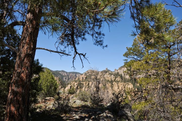
Mount Baldy on horizon

Over its 21-mile course, Railroad Grade Trail passes by five lakes, crosses three streams, and makes a creaky traverse of an old-style trestle bridge. Once used by the Apache Railroad to service bygone logging operations, the route had a brief second wind as a tourist ride before being decommissioned and repurposed into its current status as a hike/bike/horse trail. Because of its relatively flat terrain, ever-changing scenery, four  trailheads, connectivity with other popular White Mountains trails and proximity to campgrounds, hiking this 
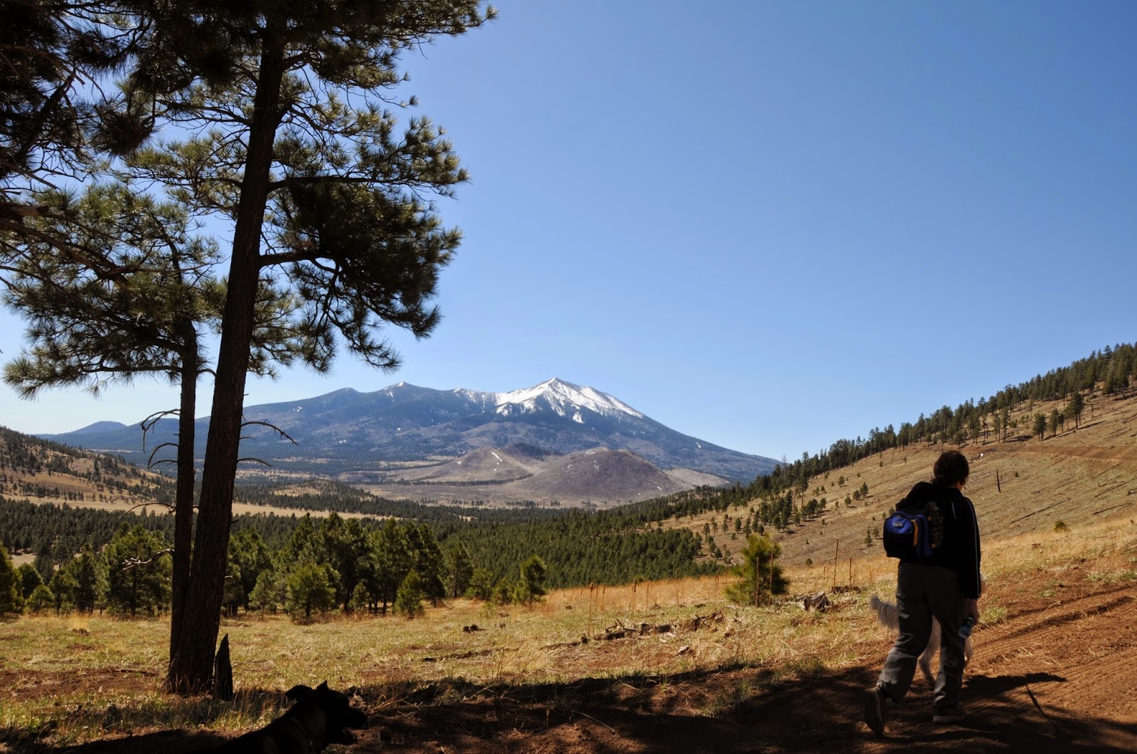
historic gem is do-able  as a long day hike or a multi-day excursion. The cinder substrate trail runs north-south between Highway 260 and Big Lake through marshes and fur-spruce woodlands flanked by the volcanic massif of Mount Baldy ridge, which at 11,420' is the second highest point in Arizona that you can hike to legally.  Mid-way through the trek, the route passes through a tunnel under AZ273 emerging at Sheep Crossing, a popular fishing spot on the West Fork of the Little Colorado River.  Here, the trek makes an easy ascent up toward the West Baldy Trail and the hike's highest point where scars from the 2011 Wallow Fire paint the forest in shades of gray. Heading down toward Big Lake, views of 10,912-foot Escudilla Mountain stand out among treeless grasslands punctuated with glassy ponds that attract blue heron, eagles and swarms of waterfowl. This is also cattle country, so  herd encounters are guaranteed, especially along the last miles leading to the trail's southern terminus at Railroad Cove---a northern estuary of Big Lake.
Sheep Crossing

 
Fence near Railroad Cove
LENGTH: 21 miles one-way
RATING: easy
ELEVATION: 8950' - 9350'
GETTING THERE:
NORTH: AZ260 Trailhead:
From Show Low, go 36 miles east on AZ260 to a point 1.5 miles beyond AZ273 at milepost 379. The signed trailhead is on the right. Paved roads. Restrooms.
MID-WAY, 8 miles from AZ260: Sheep Crossing Trailhead:
From Show Low, go 35 miles east on AZ260 to AZ 273 at milepost 377.  Turn right and go 8.8 miles south to the trailhead on the right at milepost 391. Paved Roads. No facilities.
NINE-TENTHS: 18 miles from AZ260: Lightning Ridge Trailhead:
From AZ260, go 14.3 miles south on AZ 273 to FR 116, turn right and drive a few yards to the trailhead on the right. Trail begins across the road.
Expect bovine encounters along the trail.
SOUTH: Railroad Cove at Big Lake Trailhead:
From AZ260, go 14.3 miles south on AZ273 to FR 116, turn right and continue 2.8 miles to FR 249E, turn left and drive 1.8 miles to FR249G turn left and follow the road 0.3-mile to the parking area. Forest Roads 116 and 249E/G are sedan-friendly dirt. Restrooms. 
Aspen-shaded section

INFO: Apache Sitgreaves National Forest, Springerville Ranger District, 928-333-6200
MORE PHOTOS:

Thursday, June 5, 2014

ALFA FIA TANK


ALFA FIA TANK
Flagstaff

Alfa Fia Tank

Just off Passage #34 of the Arizona Trail, a tiny pool in an alpine meadow reflects images of soaring peaks.  Here, among disheveled barbed wire, knee-high forbs, wildflowers and infant conifers, an awe-inspiring panorama of see-forever-vistas tumbles seamlessly down exposed slopes. On most days at Alfa Fia Tank, cool mountain air rushes over ambient prairies with hair-whipping ferocity. These cyclonic breezes are created when warm air creeps up the mountain and collides with crispy alpine drafts churning down from Arizona's highest massif.  This windy cocktail swirls in airy eddies muddled with pine and the earthy scent of last year's deadfall.
Places near big mountains like this one are known to create their own weather systems, and in summer, that means nippy mornings followed by cloud build ups that often erupt in afternoon rainstorms. Whether hiked as an easy stroll from Aspen Corner or as a water-gathering detour while trekking the 36.1-mile segment of the Arizona Trail that passes below the San Francisco Peaks, the mile-long walk around Alfa Fia Tank is a revitalizing trip of astonishing beauty.


LENGTH:  1.1 mile
RATING: easy
ELEVATION: 8730’ – 8932’
 
Looking west 
GETTING THERE:
From Flagstaff, go north on US 180 to Snowbowl Road (FR 516) at milepost 223.  Turn right and continue 5.3 miles to the parking apron on the left at Aspen Corner. From the opening in the fence, take the wider trail heading right, veer left at the first fork and continue straight past the Arizona Trail junction and follow the trails around the tank.

Arizona Trail Association:

MORE PHOTOS:

Rainbow Rim gets fresh tracks along the North Rim of Grand Canyon

RAINBOW RIM TRAIL EXTENTION
PHOTO: courtesy Kaibab National Forest
Kaibab National Forest PRESS RELEASE:

FREDONIA, Ariz. - Friends of the North Kaibab Ranger District, the International Mountain Bicycling Association (IMBA), the Southern Nevada Mountain Bike Association (SNMBA), Zion Cycles, and Utah Mountain Biking Tours volunteered their time this past Memorial Day weekend to break ground on the new Rainbow Rim trail extension located along the North Rim of the Grand Canyon on the Kaibab National Forest.

The Rainbow Rim trail connects five scenic vistas along 18 miles of the North Rim, and each offers its own unique view of the surrounding landscape.  The current trail begins at Parissawampitts point, continues to Fence point, Locust point, North Timp point, and ends at Timp point.

"We welcome riders to come lay down some fresh tracks as the trail extension project progresses and we encourage those who would like to volunteer to help complete the trail to join us," said Melissa Robinson, North Kaibab Ranger District recreation specialist and coordinator for the trail extension. "We have worked diligently to get this trail extension to fruition, and we are delighted to offer an awesome new scenic trail for mountain bikers, horseback riders, and hikers alike to see our forest from a completely new perspective."

The new trail extension will consist of new construction and about four miles of road-to-trail conversion. When complete, phase one of the trail extension will start at Timp point and head east in and out of the pines. The new single-track extension will offer sections for beginners to advanced riders giving everyone a unique perspective of some very epic views along the canyon rim. During the weekend of work, volunteers cut, hacked, dug and removed debris along the trail and completed 1,500 feet of the 8-mile extension.

"Eventually, the trail extension will continue and tie into the existing trail back to Parissawampitts," Robinson added. Once the loop is complete, riders will be able to ride the lollipop for nearly a full 32-mile loop.

The North Kaibab Ranger District trail crew helped scout and flag the trail extension under the supervision of experienced rider and IMBA Southwest Regional Director Patrick Kell, in order to ensure it met IMBA trail-building standards and so it would be ready for volunteers to cut and bench that weekend. The trail crew will be working throughout the summer on this and other projects on the forest.

Photos of the ongoing project are available at http://tinyurl.com/m4flmak. For updates and information on volunteering to help complete the Rainbow Rim extension, please contact Melissa Robinson at (928) 643-8120. For more information on the IMBA, please visit www.facebook.com/IMBAonFB.

-NFS-

Monday, June 2, 2014

LEROUX SPRINGS


LEROUX SPRINGS
Flagstaff

Old box at Big Leroux Spring

There's big news at Big Leroux Spring. For the first time in more than a century, this important water source at the base of Flagstaff's San Francisco Peaks has been freed from its 1930s-era concrete box. Well, partially, anyway. Having been diverted and capped for municipal drinking water for years, the spring box was reconfigured in June 2013 returning a portion of the flow to the surface. This is the first step in the restoration of the site's original wetland ecosystem and possible reintroduction of vanished native plant and animal species. Located at the head of Flagstaff's Rio de Flag watercourse, the sister springs of Big and Little Leroux have been an a critical resource for Native Americans, explorers and homesteaders. Named for Antoine Leroux, a prolific 19th century guide who assisted  the Sitgreaves Expedition and the journeys of Lt . Edward Beale (of Beale Wagon Road fame), ownership of the  springs area has changed hands numerous times over the years. It's currently owned by the U.S. Forest Service and used for firefighter operations and Hot Shot headquarters. 
With the goal of restoring the site to a healthy, self-sustaining  riparian environment, the woodlands around the springs have become an outdoor research area where ongoing data collection will aid in future conservation plans.  Restoration of the site is mostly a volunteer effort and although water flow varies with the seasons, a visit to the springs pays homage to the work of the Friends of the Rio de Flag, a local advocacy group toiling to preserve the history and hydrology of  Flagstaff's watersheds.
Meadow near Little Leroux Spring

LENGTH:  2.6 miles roundtrip
RATING: easy
ELEVATION: 7520’ – 7600’

GETTING THERE:
From Flagstaff, travel north on US180 to Snowbowl Road (FR 516) at milepost 223.
Turn right and go 1 mile to where FR 516 makes an abrupt right turn with an unmarked dirt road straight ahead.  Park along this road in front of a gate which marks the beginning of the hike.
HIKE DIRECTIONS:
From the trailhead, pass the gate using the wood stairs and hike 0.3 mile to a fork.  Go left here and continue to a second fork where you'll turn right.  At the third fork, go left for Big Leroux or right for Little Leroux.
 
Rain gauge near Hot Shot headquarters
INFO:
Friends of the Rio de Flag
Arizona Watchable Wildlife Experience
MORE PHOTOS:

Bill Williams Watershed Closure 2014

 Kaibab National Forest To Take Additional Precautions
To Prevent Human-Caused Fires
UPDATE: closure will be lifted at 8 a.m., July 8, 2014.

Kaibab NF Press Release, 6-2-2014:
 WILLIAMS, Ariz. – The Kaibab National Forest is taking additional steps to reduce the risk of preventable human-caused fires.  As of Friday (June 6) at 8 a.m. the North Kaibab Ranger District will enter campfire and smoking restrictions, and the Williams Ranger District will close the Bill Williams Mountain Watershed to public entry. 
Under the North Kaibab Ranger District’s campfire and smoking restrictions, which are also known as Stage 1 fire restrictions, fires, campfires, charcoal, coal and wood stoves will be allowed in developed campgrounds only.  The restrictions will also limit smoking to within enclosed vehicles or buildings or in developed campgrounds. 
 On the Williams Ranger District, which is already under Stage II fire restrictions, the Bill Williams Mountain Watershed will be closed to public entry.  This includes hiking, horseback riding, driving, camping and all other recreational and industrial activities.
 The Bill Williams Mountain Watershed closure area will be bounded to the east by 4th Street and County Road 73, to the south by Forest Service Road (FSR) 122, to the west by FSR 108, and to the north by Interstate 40.  (THIS INCLUDES BILL WILLIAMS MOUNTAIN TRAIL, BENHAM TRAIL, BIXLER SADDLE and all trails on or around the mountain.)
 Forest managers often close the Bill Williams Mountain Watershed to public entry during fire season.  Bill Williams Mountain is the primary watershed for the City of Williams, and a major wildfire and subsequent flooding would be devastating to the city and surrounding communities. 
The entire Williams and Tusayan ranger districts remain under Stage II fire restrictions, which prohibit campfires, even in developed campgrounds; prohibit discharging a firearm, except while engaged in a lawful hunt; and, limit many industrial activities.
 For detailed information about fire restrictions and the closure of the Bill Williams Mountain Watershed, visit www.fs.usda.gov/kaibab or call the Kaibab National Forest fire information phone line at (928) 635-8311.
 For information about fire restrictions across Arizona, visit http://firerestrictions.us/az/ or call 1-877-864-6985.


Monday, May 26, 2014

235 ROAD TRAIL


235 ROAD TRAIL
Apache Sitgreaves National Forest

Above Woods Canyon

Cutting through a coniferous forest near the edge of the Mogollon Rim, the 235 Road Trail is an easy hike with a big payoff.  The trek begins on a wide two-track dirt road flanked by enormous Ponderosa pines.  At the 0.4-mile point, go left at a signed junction heading toward Chevelon Canyon.  Here, the road passes through a wildlife habitat area replete with sun drenched meadows, watering holes and aspen trees.
Although the trail is open to bikes as well as hikers, the surrounding conservation area may only be explored on foot or horseback.  Soon, the trail becomes smothered in rows of young pines that create an enchanting “green tunnel” leading to the confluence of three striking canyons.  The trail dead-ends at a promontory point with the head of Chevelon Canyon straight ahead and the precipitous gorges of Willow Springs Canyon on the east and Woods Canyon on the west.  Excellent views can be enjoyed by wandering around the point where limestone ledges and tree roots maintain tenuous holds hundreds of feet above the abyss.
Wildlife habitat area
the  "green tunnel"

Head of Chevelon Canyon

LENGTH: 8.2 miles roundtrip
RATING: easy
ELEVATION: 7560’ – 7647’
GETTING THERE:
From the SR87/260 junction in Payson, go east (right) on SR260 to FR300 (Rim Road) located across from the Mogollon Rim Visitor Center and signed for Woods Canyon Lake. Turn left on FR 300 and continue 0.25-mile to the Rim Top trailhead on the right. The hike begins behind the big General Crook Trail sign near the restrooms. Roads are 100% paved.
INFO:
Black Mesa Ranger District, 928-535-7300

MORE PHOTOS:

Tuesday, May 20, 2014

SLIDE FIRE 2014


SLIDE FIRE: May 20, 2014
Sedona
West Fork of Oak Creek: this has just burned ....
 UPDATE: 5-26-14: good news, fire damage to Call of the Canyon and West Fork of Oak Creek is not too bad. Check out this link for photos:
 https://www.facebook.com/SlideFireInfo

UPDATE 5-21-14: West Fork of Oak Creek is burning. No words.....
Here we go again---wildfire season.  This fire, which started this afternoon, is precariously close to West Fork of Oak Creek.  Although I haven’t received an official press release from the forest service yet, this is a no-brainer---don’t plan on hiking in the Oak Creek Canyon area any time soon.  The links below provide frequent updates on the fire. And, about that 3.5-mile switchback construction shut down on SR89A, you can now add 15 miles in both directions to the closure area. Pray, chant, cast good spells or dance for West Fork and the safety of our firefighters and local residents.

InciWeb:
Coconino National Forest:
Wildfire Incident Reports:

Monday, May 19, 2014

SWITCHBACKS ON SR89A TO CLOSE FOR 5 WEEKS

HIGHWAY 89A PARTIAL CLOSURE BEGINS MAY 27, 2014

Sedona
Access to many trails above SR89A remain open.

A 3.5-mile segment of SR89A in Oak Creek Canyon will be closed for improvements beginning May 27, 2014. The 5-week project which will include repaving, guardrail upgrades and bridge repairs is expected to conclude July 2, 2014.
The closure is in the "switchbacks" area from the Pine Flat Campground to Vista Point Overlook (mileposts 387-390). The good news is that access to popular hiking trails like West Fork, Harding Springs and Thomas Point will not be affected by this closure.

CLOSURE INFO:


HIKING TRAILS IN THE AREA:

Sunday, May 18, 2014

RED BUTTE


RED BUTTE
Kaibab National Forest
Looking north toward Grand Canyon

Impossible to miss along AZ64 twenty miles south of the Grand Canyon, the russet stone pinnacle
known as Red Butte commands the landscape. Rising 866 feet above the flatlands of the Colorado Plateau, this geological wonder is comprised of ancient layers of sand, ocean deposits and river rubble capped with a layer of inky basalt.  Over the past 270 million years, the forces of nature have whittled away much of the rock, but the basalt cap preserved this sugarloaf-shaped cross section of earth history for us to climb.  A clean trail ascends the west face in a series of gradually steepening switchbacks with excellent views all the way up.  On the summit,  footpaths wander among scenic viewpoints, forest service relics, survey markers (see if you can locate all 8 of them) and a lookout tower which is staffed during fire season.  To the north, a primitive airstrip stretches across juniper and sagebrush plains with hazy views of the Grand Canyon shimmering on the horizon while the silhouettes of the San Francisco Peaks and Bill Williams Mountain are visible to the south.

Fire tower on the summit

LENGTH: 2.5 miles roundtrip
RATING: moderate
ELEVATION:  6460' - 7426'

Bill Williams Mountain on the horizon

GETTING THERE:
From Flagstaff, go north on US 180 to the AZ 64 junction in Valle. Turn north (right) and continue 11 miles to FR 320 at milepost 224.  Turn right and go 1.3 miles to FR 340, turn left and drive 0.9 mile to the FR340A, turn right and continue 0.3 mile to the trailhead. Dirt roads are sedan friendly and well signed.

INFO:
Tusayan Ranger District, Kaibab National Forest, 928-638-2443

Access roads are well signed

MORE PHOTOS:

Monday, May 12, 2014

SADDLE MOUNTAIN


SADDLE MOUNTAIN VOLCANO
Flagstaff
San Francisco Peaks viewed from Saddle Mountain

In my book, trails like this one don't get enough respect. In the grand promised land of Flagstaff-area hiking, it's easy to understand why a perfectly decent destination like Saddle Mountain would fall off the radar. Visible from US 180 just north of the Kendrick wildlife viewing area, the extinct cinder cone volcano rises 700 feet above woodlands recovering from the 2000 Pumpkin and 1996 Hochderffer fires.  In fact, several hiking books and online sources focus so much on the wildfires when describing this trail that they have failed to acknowledge its headliner attraction: fabulous views. Certainly, this mountain's proximity to much more ambitious climbs (Kendrick Peak, Humphreys Peak) doesn’t help visitation either.  Get over it---I’m going out on a limb to highly recommend this trail. The hike itself is a moderate trudge up a service road which twists up the hill candy-cane-style, revealing sweeping, 360-degree landscape vistas that stretch all the way to the Grand Canyon and Painted Desert.  To the north, geological landmarks Red Mountain and Red Butte stand out on the flat plains of the Colorado Plateau while massive San Francisco Mountain commands the southern flank. On the summit, a visual spectacle of eroding cinder cones can be seen in northern Arizona’s volcanic field while communication transmitters hum in sync with alpine breezes. 
Kendrick Peak as seen from the trail

View from the summit of Saddle Mountain

LENGTH:  5.8 miles roundtrip
RATING: moderate
ELEVATION: 8,100' - 8,800'
GETTING THERE:
From Flagstaff, go 21 miles north on US 180 to FR 514 located at milepost 236.5.  SET YOUR ODOMETER---trust me. Turn right and travel 2.5 miles east on FR 514 (stay straight, ignore all side roads) to FR 550, turn left (north) and drive 1.9 miles to where there’s a small loop turnaround road on the left. This is FR 550A, but it’s not signed.  The road climbing the mountain on the left is the trail.  Park anywhere along the road, or, there’s also a small (one car) dirt turn out roughly 0.2 mile up FR550A if you want to shorten the hike.
INFO:
Flagstaff Ranger District, Coconino National Forest, 928-526-0866

ARIZONA TRAIL TREK EVENT THIS FRIDAY IN FLAGSTAFF

 ARIZONA TRAIL TREK EVENT: FRIDAY MAY 16, 2014

Nothing says outdoor adventure quite like hiking the Arizona Trail and guzzling BEER! Come on up to the cool pines of Flagstaff ---the largest of the AZT Gateway Communities--- on Friday May 16th and enjoy a cold one with Sirena Dufault, who is passing through town on her 817-mile border-to-border hike from Mexico to Utah. With roughly two weeks to go before the completion of her journey and the goal of raising $20,000 for the promotion and maintenance of the Arizona Trail, the effort could use a major boost.
The festivities at Wanderlust Brewery will include music by Diamond Down String Band, trail talk and fun with fellow hikers, bikers and equestrains who love the Arizona National Scenic Trail

WHEN: Friday, May 16, 2014 6-9 p.m.
WHERE: Wanderlust Brewery
1519 N. Main Street, Suite 202, Flagstaff
928-351-7952
EVENT INFO:

DONATE ONLINE:

Wednesday, May 7, 2014

RIM COUNTRY LLAMA HIKES


RIM COUNTRY LLAMA HIKES 
Pine-Strawberry

The llamas of the Ranch at Fossil Creek

Several years ago after an alpine (4 a.m.) start and 15 miles of hiking 5000 feet up a Colorado 14er peak, I hauled my self up those last breathless few hundred feet to claim my victory moment, and encountered---llamas. A tour company that employs the llamas to do the heavy lifting, taking the load off the backs and feet of the climbers, had escorted a group of hikers to the mountaintop sherpa-style.  This--I learned--was the smart way to hike. Outfitted in rough-wove woolens and bell garlands that pinged in the brisk 14,000' winds, the rugged beasts (and a minor case of hypoxia) colored this Rocky Mountain wilderness in shades of Andes.  That was the day I added, "hike with llamas" to my bucket list.  As with most of the items on my list, this one mellowed into invisibility while I toodled around the state systematically working through an assortment of hiking objectives both epic and mundane. Finally through a serendipitous interest in day hikes offered in conjunction Arizona Trail Trek 2014, I was able to walk with the llamas of The Ranch at Fossil Creek. The convergence of Pine-Strawberry Trails Day and Arizona Trail hiker Sirena Dufault passing through the town on her 817-mile trans-state trek was the perfect recipe for an outdoor celebration.  On Sunday, May 4, 2014, llama wrangler, Joyce Bittner conducted a short loop hike as part of the festivities, which serve as a party style shout out to all the wonderful hiking opportunities in the area and also to support Sirena's goal to raise $20,000 for the maintenance and promotion of the Arizona Trail. In addition to miles of trails on the cool forests of the Mogollon Rim, there are plenty of other reasons to pay a visit to the twin hamlets of Pine and Strawberry. Craft events, races, historical tours, proximity to Tonto Natural Bridge State Park and local business like The Honey Stand (try the Pine Wildflower honey) and That Brewery (yummy Arizona Trail Ale) complement the perfect summer escape.

GETTING THERE:
Pine-Strawberry is located roughly 110 miles north of Phoenix on AZ87 (Beeline Hwy).

THE RANCH AT FOSSIL CREEK LLAMA HIKES
Half-day tours cost $65 per person ($40 for children under 12 years). Reservations are required.
928-476-5178

RIM COUNTRY INFO:

CONTRIBUTE TO ARIZONA TRAIL TREK:


Tuesday, May 6, 2014

RED ROCK PASS UNDER FIRE

SEDONA WRITER CHALLENGES THE RED ROCK PASS PROGRAM 
May 2014 issue
 
Is the Red Rock Pass program necessary and beneficial to protect and maintain one of the most heavily visited areas of the Coconino National Forest? Or, is it double taxation and straight up government exploitation of Sedona's rich outdoor recreational landscape? The jury is out. In the May 2014 issue of The Noise Arts & News, Sedona writer Cindy Cole grills new Red Rock District Ranger Nicole Branton about the program's purpose and challenges its legality. Whether public land fees ruffle your feathers or not, this is an interesting read for Arizona outdoor enthusiasts.

The Noise is available at 245 locations in Northern Arizona.
928-634-5001
More from the author:

Monday, May 5, 2014

GOLDWATER LAKES TRAIL #396


GOLDWATER LAKES TRAIL #396
Prescott

Upper Goldwater Lake

When completed, Prescott's Circle Trail will make a 50-mile loop tour around the mile-high city using existing hiking trails, bike routes, roads and newly constructed paths. Swooping through a mixed bag of pine-wrapped mountains, creek side greenery, windy grasslands, municipal parks, national forests and high-country lakes, the route highlights the scenic diversity surrounding Arizona's original capital city.  More than a dozen trailheads along major roads make hiking the route in segments or via car shuttle treks a cinch.  One favorite segment for day hiking in warmer months is The Goldwater Lakes Trail #396. Massive canopies of Ponderosa pine, Alligator juniper and oak provide cooling shade as the route winds above the lakes and across the boulder-flanked ravine and crisp waters of Bannon Creek. Although the trail proper does not go to the lakes, obvious spur trails will get you there. The trek is anchored by two trailheads, which connect to longer national forest routes and, of course, the rest of the Circle Trail.
Granite Mountain & Thumb Butte visible beyond the trees

LENGTH: 4.7 miles one-way
RATING: moderate
ELEVATION: 5630' - 6165'

Spur trails lead to the water

GETTING THERE:
East Trailhead:
From Phoenix, travel north on I17 to the Cordes Junction interchange and head west on AZ69. Follow AZ69  to Senator Hwy/Mt. Vernon Ave., turn left and continue 4 miles the Watershed  #299 trailhead on the left. Trail #396 begins across the road.
West Trailhead:
Follow directions above, but continue past Mt. Vernon Ave to Montezuma St. (a.k.a. White Spar Dr, AZ89). Turn left and go 3 miles south to the White Spar Campground on the left.

Pools at Bannon Creek

Prescott Circle Trail & Maps:
MORE PHOTOS:

Tuesday, April 29, 2014

McDowell Sonoran Conservancy Photo Contest 2014

McDowell Sonoran Conservancy Photo Contest 2014
Climbing Sunrise Peak

Trekkers, now that one of the best ever hiking "high seasons"is drawing to a close, it's time to shuffle through all those terrific photos you took while exploring Scottsdale's McDowell Sonoran Preserve. Each year, the McDowell Sonoran Conservancy sponsors a focus on conservation photo contest to draw attention to the preserve's trails, facilities and educational opportunities. Selected photos will be eligible for prizes and displayed on the organization's website. Please participate, tell your friends and better yet, click the SUPPORT link to contribute to ongoing land preservation efforts. Photo entry deadline is May 31, 2014.

ENTER THE PHOTO CONTEST HERE:
http://www.mcdowellsonoran.org/content/pages/contestEntry2#sthash.mqPtcEIa.dpbs

Sunday, April 27, 2014

AGUA FRIA CONSERVATION AREA


AGUA FRIA CONSERVATION AREA
Lake Pleasant Regional Park
A bend in the Agua Fria River

Closed to motorized vehicles since 2007, this 2,405-acre riparian corridor is recovering from years of abuse.  Until recently, this mesa-flanked swath of the Agua Fria River which flows into the north end of Lake Pleasant was full of trash and off-road vehicles were destroying the waterway and its native wildlife habitats.  Although it’s located just 4 miles from busy Interstate 17, and motorized traffic is allowed in the surrounding Table Mesa Recreation Area, there’s a pronounced wilderness feel here.  Water levels fluctuate with the seasons, but even in the driest months, tiny pools and rivulets feed emerald bands of cottonwoods, willows and mesquite bosques that host swarms of birds including swifts, doves, raptors and even elusive Vermilion Flycatchers.  Along the sandy riverbanks, colorful tufts of wildflowers and two species of native wild tobacco embellish the homes of egrets, herons and killdeer while framing the footprints of myriad forest critters.  From the trailhead, it’s a 2-mile hike to the northern shore of the lake. Follow the closed roads or faint footpaths to explore and appreciate how restoration efforts are giving this hauntingly beautiful site a second chance at life.

Critter footprints with Indian Mesa in the distance

LENGTH: 4 miles round trip
RATING: easy
ELEVATION: 1983’ – 1640’
FEE: $6 daily fee per vehicle (bring exact amount for self-serve pay station)
SEASONAL CLOSURES: Area may be closed during Bald Eagles are nesting. Check Lake Pleasant Regional Park website before visiting.

Thistle at the base of Wild Burro Mesa

GETTING THERE:
From Phoenix, go north on I17 to Table Mesa Road exit 236.  Turn left, cross the freeway, make a right and then a left onto Frontage Road. Continue 1.1 mile to a fork near a rock quarry and veer right.  At 1.6 miles, go left at a second fork and left again at a 3rd fork at 3.8 miles. At the 4.2-mile point, cross a cattle guard (corral area on left) and continue another 0.4 mile to the signed parking area. Dirt roads are sedan-friendly.
Tree tobacco plants can grow to 20' in height

INFO & MAPS: Lake Pleasant Regional Park
MORE PHOTOS:

Monday, April 21, 2014

UPCOMING ARIZONA TRAIL TREK 2014 DAYHIKES


UPCOMING ARIZONA TRAIL TREK 2014 DAYHIKES
AZT near Sandy's Canyon

During the month of May, Arizona Trail thru-hiker Sirena Dufault will be trekking north over the Mogollon Rim and through Flagstaff on her way to the Utah border. She'll be stopping along the way for meet-and-greet events and day hikes with supporters. Here's just a sampling of upcoming AZT Trek events for you to connect with outdoor enthusiasts, learn about the trail and speak with Sirena to understand how this program will benefit the 817-mile Arizona National Scenic Trail. Sirena’s objective is to raise $20,000 for the maintenance, promotion and protection of the AZT. So far, the fundraising effort is at 25% of goal. All events are free, however, donations are appreciated, and if you cannot get to an event, you can donate online by clicking the link below. If you're reading this blog, you must be a hiker---so, please step up and help support Arizona's premier trail. 

Sunday, May 4, 2014:  Llama Dayhike from the Pine Trailhead

Thursday, May 15, 2014: Sandy’s Canyon to Flagstaff

Saturday, May 17, 2014: Schultz Pass Road to Snowbowl Road

DONATE:

Sunday, April 20, 2014

BLACK CANYON HERITAGE PARK


BLACK CANYON HERITAGE PARK
Black Canyon City

A sign at the park entry urges visitors to close the gate to “keep the cows out”. Here, in a valley between I17 and the Bradshaw Mountains, there may well be marauding bovines, however, Black Canyon Heritage Park is all about sheep, fish and preservation of a rare stream side ecosystem.
Spawned by a generous donation of land, community activism and the help of numerous grants including one from the National Park Service Rivers Trails and Conservation Assistance Program, this 25-acre park opened in November 2012.  Thus far, 23.5 acres of riparian desert along the Agua Fria River have been restored with constructed streams, lush vegetation and ponds stocked with native fish. Two barrier free loop trails wander among cattail coves, willow-cottonwood forests and a pine-shaded picnic area with interpretive signs detailing the area’s sheep herding heritage. Located just over a mile north of a major trailhead for the Black Canyon National Recreational Trail, this pretty little place makes for an interesting side trip or post hike lunch spot.


LENGTH: 0.8 mile
RATING: easy, barrier free
ELEVATION: 1915’ – 1945’
FEES: none, however donations can be made online
DOGS: not allowed
Red-winged blackbird
GETTING THERE: 33955 S. Old Black Canyon Highway, Black Canyon City.
From Phoenix, go north on I17 to exit 242 for Rock Springs/Black Canyon City. Go west (left) to Old Black Canyon Hwy. (Frontage road), turn right (toward BCC) and continue 1.2 miles to the park on the right just north of Schoolhouse Road.

INFO:

Monday, April 14, 2014

Midgley Bridge trailhead temporarily closed

MIDGLEY BRIDGE TRAILHEAD IN SEDONA TO BE CLOSED APRIL 21-MAY 9, 2014
Midgley Bridge spans Oak Creek
UPDATE 4-30-14: closure has been extended from May 2 to May 9, 2014.
If you're planning a hike on Sedona's Wilson Canyon/South Wilson Mountain trails in the next couple of weeks, you won't be able to use the "Midgley Bridgely" trailhead on AZ89A near milepost 376.  That's because it's being temporarily closed for improvements that will include (finally) an accessible toilet. (Yup, I can hear you cheering). A fenced enclosure will prohibit public access during construction.  North Wilson trail can still be accessed at the Encinoso picnic area farther up the road near milepost 379.
For more information, contact the Red Rock Ranger District, Coconino National Forest, at 928-203-2900.