CLIFFHANGER-LIME KILN TRAIL
 |
| Yucca bloom on Cliffhanger Trail |
In a nutshell, the Cliffhanger Trail does what it says. The edge-hugging multi-use trail in west Sedona lives up to its name with a thrilling and scenic trip through a creek-scoured corner of Coconino National Forest where the courses of Oak, Dry and Turkey Creek collide.
 |
| A high point vista on Cliffhanger Trail |
While Cliffhanger is billed as an OHV trail, it’s more of a hybrid. Part of its forked route shares space with the 15-mile Lime Kiln Trail that runs between Red Rock and Dead Horse Ranch State Parks with one fork leading to a non-motorized footpath that lands at a secluded floodplain on Oak Creek.
 |
| Basket cairns mark the Lime Kiln section of the route |
The hike starts at the OHV trailhead with a short walk on Forest Road 9845A. At the bottom of a rise at a green gate, the road bends left and joins the Lime Kiln Trail that’s marked by basket cairns (rock piles wired into pillars).
 |
| Meadow and cliffs near trail's end. |
 |
| Edible skunk bush fruits favored by birds and mammals |
The route is also indicated with orange Cliffhanger trail posts. The road continues downhill on a moderate grade through classic high desert vegetation.
 |
| Cat Claw bloom May - August |
Yucca, red barberry, prickly pear cactus, catclaw, and gray thorn line the russet, rocky trail. At the 1.5-mile point, the road crosses Dry Creek.
 |
| Edible red barberry fruits are browsed by wildlife |
 |
| Lime Kiln Trail crosses Dry Creek |
 |
| A cliff hanging section of Cliffhanger Trail |
Strewn with colorful boulders, there’s rarely any surface water, but a leafy fringe of cottonwoods, sycamores, desert willows and cypress trees springing from the sandy soils soak up subterranean moisture. Beyond the creek, the route swings back uphill on one of a continual string of ups-and-downs that add up to over 1,100 feet of total elevation change for the hike.
 |
| Stone foundations at trail's end at Oak Creek |
With the serpentine course of Dry Creek below and views of Sedona rock formations all around, the road is hacked from red sandstone cliffs with steep drop-offs. Except for the occasional juniper or pinyon pine, there’s little shade.
 |
| Willows and cypress trees line Dry Creek |
That’s why is important to choose a cool day and take plenty of water on this hike. At the 2-mile point, the road splits. Lime Kiln Trail veers left following the north fork of Cliffhanger and Forest Road 9845N, the south fork of the Cliffhanger Trail, heads right.
 |
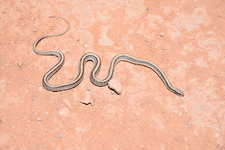
| Western patch-nosed snake crosses Cliffhanger Trail |
 |
| Dry Creek winds below Cliffhanger Trail |
For this trip, follow FR9845N as it rounds a knoll before starting its dive down to Oak Creek. This leg vacillates between canyon-bound grasslands and highpoints with views of the Bradshaw Mountains topping out at a sharp right bend where the route makes a severe dive on a rough, tiered track. Below, a brilliant band of green belies the Oak Creek corridor.
 |
| Engelmann's prickly pear cactus bloom May - June |
 |
| Banana yucca fruits |
The short steep section lands in a pocket of juniper woodland where the road suddenly changes from rusty red to powdery gray. Up ahead at 3.3 miles, a green gate bars motorized access to the remainder of FR9845N. Hikers, bikers and equestrians are welcome to trudge the last 0.4-mile. Tracing Oak Creek, the deeply rutted narrow road progresses to the hike’s lowest point, a grassy meadow hemmed in by the creek and vertical cliffs.
 |
| The last half-mile of Cliffhanger non-motorized use |
A native stone foundation and low walls that might have been a cabin or corral stand on the creek’s west bank.
 |
| Trees clutter around Oak Creek |
 |
| View from Lime Kiln Trail |
The stone ruins make for a good turnaround point, however FR9845N continues a short distance through the meadow and another faded dirt track, FR9845R offers a weedy walk through a quiet high desert creek corridor.
 |
| Banana yucca bloom April - July |
LENGTH: 7.4 miles roundtrip
RATING: moderate
ELEVATION: 4,085 – 3,708 feet (1,100 feet of accumulated elevation change)
GETTING THERE:
From the State Route 179/89A traffic circle in uptown Sedona, go 8 miles west (toward Cottonwood) on SR89A to the Cliffhanger OVH trailhead (Forest Road 9845A) on the left. This is directly across from the Sedona Wetlands Preserve near milepost 366.
INFO & MAPS:
https://www.fs.usda.gov/recarea/coconino/recarea/?recid=83430


No comments:
Post a Comment