CORDUROY WASH
 |
| Stock tank in Corduroy Wash attracts wildlife |
Tucked into coniferous woodlands at the edge of the Mogollon Rim a few miles east of Fossil Springs Wilderness and north of the prominent rock jetty of Milk Ranch Point, numerous drainages spill south percolating through the Rim’s vertical walls to contribute to
important watersheds that eventually flow into the Verde and Salt Rivers.
 |
| The hike follows FR 9385 |
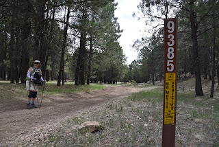
Among these scoured channels is Corduroy Wash which cuts shallow ravines in the forested space between State Route 260 and Forest Road 149 in Coconino National Forest. This quiet drainage area may be explored by walking Forest Road 9385. The road is also part of the General Crook Trail No.130, that was built in 1870s and stretched between Fort Whipple and Fort Apache.
 |
| Mountain dandelions bloom May through Oct. |
Twenty five miles of the formerly 200-mile historic military wagon route that roughly follows Rim Road (Forest Road 300) is maintained by the forest service and is denoted by distinctive white chevron tree tags used to mark the trail remain intact. While the tree tags are sparse, and not so easy to spot, finding your way along FR 9385 is a cinch. The road is well signed, wide and presents no major obstacles. Here’s how to hike it. From the parking area on SR 260, pass the gate (close it behind you) and head out on the old dirt two-track that’s open to motorized use.
 |
| Most of the route is on a non-motorized road |
This sunny section is prime wildflower territory. Look for low-growing Southwestern Lewisia, brilliant yellow mountain dandelions, wood betony and delicate Fendler’s sandwort growing among pine needles and limestone boulders.
 |
| Low-growing Southwestern lewisia color the trail |
At the 0.7-mile point, a pine-rimmed stock tank (wildlife water hole) on the left reflects the sky and attracts wildlife.
Check out its muddy edges for the signatures of elk, deer, raccoons and even black bears. A few yards beyond the tank, a gate marks the beginning of the non-motorized part of this hike.
 |
| Escape Valley heat on the Mogollon Rim |
Pass the gate (again, close it behind you), veer left at the next fork and watch your step as the road begins an easy descent onto the riffled gorge of Corduroy Wash.
 |
| The PBJ Pack dog-tested and approved the hike |
The approachable, yet remote-feeling environment that vacillates between deep woods and bright meadows is an ideal place to hike with dogs. On my recent hike here, I ran into the PBJ Pack, a Glendale Arizona-based canine “adventure squad” consisting of hilariously-dressed Maltese-Pekinese-Yorkie-Poodle hikers Pebbles, Benji, Bruiser and Jax along with their human companions Brandi and Pete.
 |
| Fendler's sandwort blooms April through Sept. |
Although some members of the pack are older and have special needs they found that Corduroy Wash is an enjoyable place to get outside and smell the world.
 |
| Hike begins across from Twentynine Mile Lake |
Follow their adventures at pbjpack.com.
 |
| Hike goes through deep woods and open meadows |
The hike ends where the non-motorized two-track connects with Forest Road 149, but numerous tangent back roads offer opportunities to escape Valley heat by wandering at will in the cool shade of the Mogollon Rim.
 |
| April -June is the best time to see wood betony |
LENGTH: 4.8 miles roundtrip
RATING: easy
ELEVATION: 6,982 – 7,160 feet
GETTING THERE:
From Interstate 17 in Camp Verde, take the State Route 260 exit 287 heading east toward Payson. Continue 32.5 miles on SR 260 (Zane Grey Highway) to Forest Road 9385 a dirt road on the left about a quarter-mile past milepost 250 at Twentynine Mile Lake. This is 1.2 miles north of the State Route 87 junction for those coming north from the Pine-Strawberry area. Park in dirt pullouts. There’s additional parking across the road along FR9366R near Twentynine Mile Lake.
INFO:
https://www.fs.usda.gov/recarea/coconino/recreation/recarea/?recid=55312


No comments:
Post a Comment