WHITE MESA TRAIL
 |
| The view from the top of White Mesa |
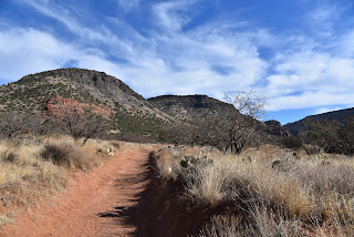
From the hyper popular Bell Trail, the imposing, vertical cliffs of White Mesa appear as an unsurmountable wall of stone.
 |
| Hike goes to the top of the mesa:center horizon |
Rising over 1,000 feet above one of the most heavily visited trails in Coconino National Forest 40 miles south of Flagstaff, the mesa is composed of colorful layers of red sandstone, buff-colored sediments and a cap of dark volcanic rock.
 |
| Trail departs Bell Trail 1.7 mile from the trailhead |
For those willing to make a detour from the water-centric trail that traces perennially flowing Wet Beaver Creek, the mesa’s secrets may be explored by way of the White Mesa Trail #86.
 |
| The only tricky spot on the trail passes a rock jam |
 |
| White Mesa towers over the Bell Trail |
To get to it, first hike 1.7 miles on the Bell Trail. Along this easy stretch that follows a wide dirt road that was once used to access mid-20th century ranch operations, keep an eye out for petroglyphs pecked into boulders on the north side of the road and foot paths that lead to icy pools in the creek. The route enters Wet Beaver Creek Wilderness where the White Mesa trail departs the road at the head of Casner Canyon. Leaving the leafy riparian corridor dominated by sycamore and cottonwood trees, the trail heads uphill on the western flanks of the canyon. While there are no switchbacks to ease the climb, the trail makes a constant but manageable ascent on a rocky single track.
 |
| The trail is clear and easy to follow |
Like the Bell Trail, this one was originally used to move cattle to graze on high pastures. Its straight-up, edgy course passes through mostly shade less grasslands, cacti, rockfalls and the occasional mesquite tree clinging to steep slopes.
 |
| A hiker nears the summit of White Mesa |
 |
| The grassy summit of White Mesa |
The trail is clear and easy-to-follow with only one spot where some hand-over-foot scrambling is required to get through a rock jam.
 |
| A pastoral scene on White Mesa |
At 3 miles from the trailhead, the path meets a barbed wire fence at the wilderness boundary that’s the official end of the trail. However, to enjoy the full experience of this hike, you’ll want to pass the gate (close it behind you) and continue on well-worn paths-of-use.
 |
| Part of the hike follows Wet Beaver Creek |
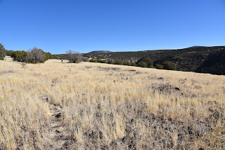
The route tops out on a grassy, juniper-dotted plateau with excellent vistas all around.
 |
| Watch for petroglyphs on Bell Trail |
Directly below, a dizzying gorge wraps around the mound of 5,131-foot Casner Butte.
 |
| The edge-hugging path climbs over 1,000 feet |
To the northeast, the tip of 7,307-foot Apache Maid Mountain, Round Mountain (6,328 feet) and Table Mountain (6,197 stand out over rows of less prominent hills and mesas giving a birds-eye view of the wild landscape that surrounds this beloved Verde Valley recreation hub.
 |
| Casner Butte (left) stands out over Bell Trail |
 |
| Vertical volcanic rock caps White Mesa |
LENGTH: 6.5 miles round trip
RATING: moderate
ELEVATION: 3,828 – 4,925 feet
GETTING THERE:
From Interstate 17 north of Camp Verde, take the Oak Creek/Sedona exit 298. Head left (east) at the bottom of the off ramp and go 2.2 miles on Forest Road 618 to the main Bell Trail parking lot.
There’s a restroom at the trailhead. Forest Road 618 is maintained dirt and suitable for all vehicles. There are no fees.
INFO:
Coconino National Forest
https://www.fs.usda.gov/recarea/coconino/recarea/?recid=55434


No comments:
Post a Comment