Spanning
the space Northeast of the Verde River between the communities of
Bridgeport and Cornville is a system of trails that just got a shot
in the arm. Although the trails have been around for awhile, a recent
influx of grant dollars has helped fund new trailheads, signs and
fresh trail construction. The Cornville Non-Motorized Trails project
is being coordinated by Yavapai County and the Cornville Community
Association in partnership with the Forest Service. The overall goal
is to establish a 12-mile network of routes to link the two towns.
The work-in-progress is coming together quickly and is now open to
hiking, biking and equestrian use.
The trails located between Zalesky
and Tissaw Roads are mostly complete, signed and easy to follow. This
segment of the system is anchored by the Backbone Trail which passes
through a wash-riddled high desert with views of Jerome and Mingus
Mountain to the west and Sedona to the north.
 |
| New signs were installed in March 2017 |
 |
| Backbone Trail |
 |
| Cliff-rose and paintbrush |
 |
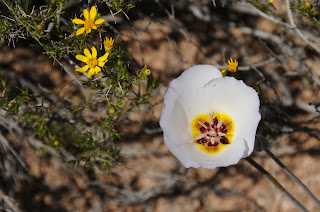
| Sego lilies bloom along the trails |
LENGTH:
12 miles total
RATING:
easy-moderate
ELEVATION:
3170' - 3560'
GETTING
THERE:
Zalesky
Road Trailhead (Bridgeport):
From
Interstate 17 north of Camp Verde, take the McGuireville exit 293 and
go 12.3 miles west on Cornville Road to State Route 89A. Turn left
and continue 1 mile to Zalesky Road, turn left and go 0.1 to the
trailhead on the left.
Tissaw
Road Trailhead (Cornville):
From
Interstate 17 north of Camp Verde, take the McGuireville exit 293 and
go 11.2 miles west on Cornville Road to Tissaw Road. Turn left and
continue 1 mile to the trailhead on the right.


No comments:
Post a Comment