


INNER BASIN
Flagstaff
 |
| Entering Inner Basin, Sept. 29, 2012 |
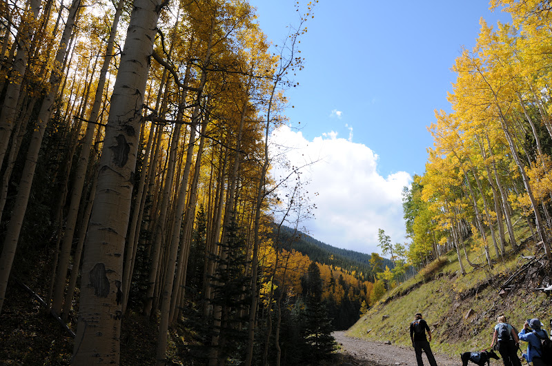
It’s aspen overload time on Flagstaff’s Inner Basin Trail.
This week should be the PEAK TIME to hike this trail, which twists uphill from
beautiful Lockett Meadow, through corridors of white-barked aspens and then
takes on an unrelenting uphill slog to a point on the Weatherford Trail where
you can look back down on the route. Offering unsurpassed views of golden color
from below, within and above, you’d be hard pressed to find a better trail for
aspen leaf peeping.
 |
| Inner Basin, Sept. 29, 2012 |
 |
| View of Inner Basin from Weatherford Trail |
In addition to the glorious autumn color show, majestic
lava-born slopes surround hikers with avalanche paths streaming from the
desolate tundra above tree line into quiet aspen-and-fir ringed meadows
thousands of feet below. For a fall color hike, it would be easy to get your
fill within a few yards of the trailhead---but what's the fun in that? The first 1.6-mile segment climbs 800
feet on a slender dirt path then merges with a wide, dirt service road. It's here where the climb enters
"spring alley" and becomes more difficult. Jack Smith, Raspberry and Doyle springs are located close to
the trail and make convenient breath-catching distractions. I usually bring a
small empty bottle to fill at the spigot where untreated spring water runs
spordically. This area is the primary
water source for the City of Flagstaff and you'll pass several maintenance
buildings along the trail. Past
the buildings, the trail enters Inner Basin proper for wide-open vistas hemmed
in by the San Francisco Peaks.
Beyond the Basin, the trail leaves the aspens behind and begins a
grueling ascent through forests of white pine and Douglas firs. The final .25-mile is marked by a
series of switchbacks leading to Weatherford Trail and a beautiful scenic ridgeline
with great views of the Painted Desert and the aspen forests below. We returned
the way we came, however, if you're feeling energetic, you can continue another
3.5 miles and 1,643 feet to the roof of Arizona ----12,633' Humphreys Peak.
 |
LENGTH: 4 miles
one way
RATING: easy, then difficult
ELEVATION: 8,600' - 10,990'
DISTANCE FROM PHOENIX: 165 miles
GETTING THERE:
From Phoenix, travel north on I17 to the I40 junction in
Flagstaff. Head east on I40 and
connect with US89 north. Continue
17 miles north on US89 to FR 420 at milepost 431.2 (across from the turnoff for Sunset Crater). Turn left here and veer left onto FR
552, following the signs 4.5 miles to Lockett Meadow. The good gravel roads are narrow and winding with steep drop offs and no guardrails. Sedans okay, drive slowly and watch those curves. Trailhead parking is just past the campground.
FACILITIES: restrooms, camping (fee area), trailhead parking
is free
INFO: Flagstaff Ranger District, Coconino National Forest,
928-526-0866
MORE PHOTOS:
1 comment:
I have travel to tucson on occasion but would LOVE to get up to the high country and hike around. This blog will be useful for when I do get up there. Thanks
Post a Comment