


 RANCH TRAIL
Prescott National Forest
RANCH TRAIL
Prescott National Forest
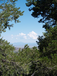
Cavernous ravines, high-desert washes and rolling ridgelines combine for a captivating hike in the foothills of the Bradshaw mountains. Closed to motorized vehicles, the Ranch Trail #62 offers a quieter hiking experience than other shared-use routes in the district. The track rambles from ridge-to-ridge in a gently undulating rhythm through a maze of pinon pines, agaves and weather-worn boulders. The gritty earth underfoot shimmers with minerals exposed by the decaying granite that defines the area’s geology. Hovering around 6,000 feet in elevation, the trail is situated high enough above the Prescott valley to showcase fabulous views of Granite Mountain floating above the green glens that ring the town a thousand feet below.
LENGTH: 6.4 miles round-trip
RATING: moderate
ELEVATION: 5,600 – 6,500 feet
FEE: $2 daily fee per vehicle.
BEST SEASONS: April - October
GETTING THERE:
From Phoenix, travel north on I-17 for the Cordes Junction interchange. Go west on Highway 69 toward Prescott. Just before entering town, turn left (south) onto Walker Road (Country Road 57) and continue for a half-mile to the “62” trailhead on the right. Roads are paved all the way and there’s a restroom at the trailhead.
Information: fs.fed.us/r3/Prescott (928) 771-4700


 RANCH TRAIL
Prescott National Forest
Cavernous ravines, high-desert washes and rolling ridgelines combine for a captivating hike in the foothills of the Bradshaw mountains. Closed to motorized vehicles, the Ranch Trail #62 offers a quieter hiking experience than other shared-use routes in the district. The track rambles from ridge-to-ridge in a gently undulating rhythm through a maze of pinon pines, agaves and weather-worn boulders. The gritty earth underfoot shimmers with minerals exposed by the decaying granite that defines the area’s geology. Hovering around 6,000 feet in elevation, the trail is situated high enough above the Prescott valley to showcase fabulous views of Granite Mountain floating above the green glens that ring the town a thousand feet below.
LENGTH: 6.4 miles round-trip
RATING: moderate
ELEVATION: 5,600 – 6,500 feet
FEE: $2 daily fee per vehicle.
BEST SEASONS: April - October
GETTING THERE:
From Phoenix, travel north on I-17 for the Cordes Junction interchange. Go west on Highway 69 toward Prescott. Just before entering town, turn left (south) onto Walker Road (Country Road 57) and continue for a half-mile to the “62” trailhead on the right. Roads are paved all the way and there’s a restroom at the trailhead.
Information: fs.fed.us/r3/Prescott (928) 771-4700
RANCH TRAIL
Prescott National Forest
Cavernous ravines, high-desert washes and rolling ridgelines combine for a captivating hike in the foothills of the Bradshaw mountains. Closed to motorized vehicles, the Ranch Trail #62 offers a quieter hiking experience than other shared-use routes in the district. The track rambles from ridge-to-ridge in a gently undulating rhythm through a maze of pinon pines, agaves and weather-worn boulders. The gritty earth underfoot shimmers with minerals exposed by the decaying granite that defines the area’s geology. Hovering around 6,000 feet in elevation, the trail is situated high enough above the Prescott valley to showcase fabulous views of Granite Mountain floating above the green glens that ring the town a thousand feet below.
LENGTH: 6.4 miles round-trip
RATING: moderate
ELEVATION: 5,600 – 6,500 feet
FEE: $2 daily fee per vehicle.
BEST SEASONS: April - October
GETTING THERE:
From Phoenix, travel north on I-17 for the Cordes Junction interchange. Go west on Highway 69 toward Prescott. Just before entering town, turn left (south) onto Walker Road (Country Road 57) and continue for a half-mile to the “62” trailhead on the right. Roads are paved all the way and there’s a restroom at the trailhead.
Information: fs.fed.us/r3/Prescott (928) 771-4700
No comments:
Post a Comment