


 HEADWATERS TRAIL
West Clear Creek Wilderness
HEADWATERS TRAIL
West Clear Creek Wilderness
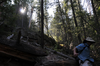
Looking for a challenge? This discombobulated, demolition zone of a trail offers a dour dose of adventure for denizens of danger. Perhaps that’s why, on any given weekend, droves of adrenaline junkies flock to this primitive route, which drops into the wild upper reaches of West Clear Creek.
The “trail” starts at an old, non-descript wood post at the northwest end of the parking area progressing downhill through an insanely steep quagmire of dead trees, moss-encrusted boulders and scree -- for a memorable, vertical plunge. The difficult climbing ends at the bottom of the canyon where the waters of West Clear Creek lap up against contorted, towering cliffs and slender sandbars. Beyond this point, wading, swimming and bushwhacking are required to continue exploring either up or downstream. Head left to see the famous “hanging gardens”—limestone cliffs imbedded with drooping green plants---or, go right and follow the waterway to a gallery of ancient rock art.
HIGHLIGHTS: be warned-- this is the steepest, wettest (and therefore the most fun) route to West Clear Creek
LENGTH: 1-mile roundtrip (from the rim to the creek)
ELEVATION: 6,600 – 5,950 feet
RATING: insane
BEST SEASONS: April - October
DISTANCE FROM PHOENIX: 113 miles one-way
GETTING THERE:
From Payson, go north on AZ 87 (toward Pine-Strawberry) to AZ 260. Turn left (west) and follow 260 3.1 miles to Forest Road 144, near milepost 249. Turn right (east) and go 1.8 miles to Forest Road 149, turn left (north) and continue to a 3-way junction at Forest Road 142. Go right onto FR 142 and drive 0.9 miles to Forest Road 142E on the left---this is an easy-to-miss unmarked road—if you reach Forest Road 142F, you’ve gone too far. Follow FR 142E 2.7 miles to a large, unsigned parking area.
INFORMATION: refer to the Coconino National Forest map, USGS map, Calloway Butte


 HEADWATERS TRAIL
West Clear Creek Wilderness
Looking for a challenge? This discombobulated, demolition zone of a trail offers a dour dose of adventure for denizens of danger. Perhaps that’s why, on any given weekend, droves of adrenaline junkies flock to this primitive route, which drops into the wild upper reaches of West Clear Creek.
The “trail” starts at an old, non-descript wood post at the northwest end of the parking area progressing downhill through an insanely steep quagmire of dead trees, moss-encrusted boulders and scree -- for a memorable, vertical plunge. The difficult climbing ends at the bottom of the canyon where the waters of West Clear Creek lap up against contorted, towering cliffs and slender sandbars. Beyond this point, wading, swimming and bushwhacking are required to continue exploring either up or downstream. Head left to see the famous “hanging gardens”—limestone cliffs imbedded with drooping green plants---or, go right and follow the waterway to a gallery of ancient rock art.
HIGHLIGHTS: be warned-- this is the steepest, wettest (and therefore the most fun) route to West Clear Creek
LENGTH: 1-mile roundtrip (from the rim to the creek)
ELEVATION: 6,600 – 5,950 feet
RATING: insane
BEST SEASONS: April - October
DISTANCE FROM PHOENIX: 113 miles one-way
GETTING THERE:
From Payson, go north on AZ 87 (toward Pine-Strawberry) to AZ 260. Turn left (west) and follow 260 3.1 miles to Forest Road 144, near milepost 249. Turn right (east) and go 1.8 miles to Forest Road 149, turn left (north) and continue to a 3-way junction at Forest Road 142. Go right onto FR 142 and drive 0.9 miles to Forest Road 142E on the left---this is an easy-to-miss unmarked road—if you reach Forest Road 142F, you’ve gone too far. Follow FR 142E 2.7 miles to a large, unsigned parking area.
INFORMATION: refer to the Coconino National Forest map, USGS map, Calloway Butte
HEADWATERS TRAIL
West Clear Creek Wilderness
Looking for a challenge? This discombobulated, demolition zone of a trail offers a dour dose of adventure for denizens of danger. Perhaps that’s why, on any given weekend, droves of adrenaline junkies flock to this primitive route, which drops into the wild upper reaches of West Clear Creek.
The “trail” starts at an old, non-descript wood post at the northwest end of the parking area progressing downhill through an insanely steep quagmire of dead trees, moss-encrusted boulders and scree -- for a memorable, vertical plunge. The difficult climbing ends at the bottom of the canyon where the waters of West Clear Creek lap up against contorted, towering cliffs and slender sandbars. Beyond this point, wading, swimming and bushwhacking are required to continue exploring either up or downstream. Head left to see the famous “hanging gardens”—limestone cliffs imbedded with drooping green plants---or, go right and follow the waterway to a gallery of ancient rock art.
HIGHLIGHTS: be warned-- this is the steepest, wettest (and therefore the most fun) route to West Clear Creek
LENGTH: 1-mile roundtrip (from the rim to the creek)
ELEVATION: 6,600 – 5,950 feet
RATING: insane
BEST SEASONS: April - October
DISTANCE FROM PHOENIX: 113 miles one-way
GETTING THERE:
From Payson, go north on AZ 87 (toward Pine-Strawberry) to AZ 260. Turn left (west) and follow 260 3.1 miles to Forest Road 144, near milepost 249. Turn right (east) and go 1.8 miles to Forest Road 149, turn left (north) and continue to a 3-way junction at Forest Road 142. Go right onto FR 142 and drive 0.9 miles to Forest Road 142E on the left---this is an easy-to-miss unmarked road—if you reach Forest Road 142F, you’ve gone too far. Follow FR 142E 2.7 miles to a large, unsigned parking area.
INFORMATION: refer to the Coconino National Forest map, USGS map, Calloway Butte
No comments:
Post a Comment