


 Horton Creek-Horton Spring
Tonto National Fores
Horton Creek-Horton Spring
Tonto National Forest
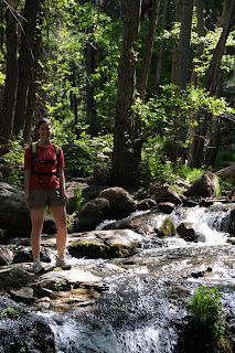
This popular trail never fails to please. Following shady Horton Creek for most of its length, this beautiful trail treats hikers to a non-stop show of waterfalls, fields of wildflowers, wild berries and forests of maples, alders and pines. The semi-grueling uphill jaunt pays off big time at Horton Spring where icy water gushing from a rock cliff tumbles over moss-encrusted boulders into the creek. Its impossible to get tired of this classic Arizona trail.
LENGTH: 8 miles roundtrip
ELEVATION: 5,360 – 6,420 feet
RATING: moderate
BEST SEASONS: March - November
DOG RATING: 3 paws
DISTANCE FROM PHOENIX: 108 miles one-way
GETTING THERE:
From the junction of AZ 87 and AZ 260 in Payson, go right (east) and continue on 260 for just under 17 miles (near milepost 268), turn left onto Fish Hatchery Road (Forest Road 289) and go 1 mile to the parking area. From the parking area, hike back down the road, cross the bridge and follow the road to the Horton Campground and the signed trailhead.
INFORMATION: Payson Ranger District (602) 225-5200, www.fs.fed.us/r3/tonto/recreation/rogs/hikingtrail/prd/HortonCreekTrail285.pdf


 Horton Creek-Horton Spring
Tonto National Forest
This popular trail never fails to please. Following shady Horton Creek for most of its length, this beautiful trail treats hikers to a non-stop show of waterfalls, fields of wildflowers, wild berries and forests of maples, alders and pines. The semi-grueling uphill jaunt pays off big time at Horton Spring where icy water gushing from a rock cliff tumbles over moss-encrusted boulders into the creek. Its impossible to get tired of this classic Arizona trail.
LENGTH: 8 miles roundtrip
ELEVATION: 5,360 – 6,420 feet
RATING: moderate
BEST SEASONS: March - November
DOG RATING: 3 paws
DISTANCE FROM PHOENIX: 108 miles one-way
GETTING THERE:
From the junction of AZ 87 and AZ 260 in Payson, go right (east) and continue on 260 for just under 17 miles (near milepost 268), turn left onto Fish Hatchery Road (Forest Road 289) and go 1 mile to the parking area. From the parking area, hike back down the road, cross the bridge and follow the road to the Horton Campground and the signed trailhead.
INFORMATION: Payson Ranger District (602) 225-5200, www.fs.fed.us/r3/tonto/recreation/rogs/hikingtrail/prd/HortonCreekTrail285.pdf
Horton Creek-Horton Spring
Tonto National Forest
This popular trail never fails to please. Following shady Horton Creek for most of its length, this beautiful trail treats hikers to a non-stop show of waterfalls, fields of wildflowers, wild berries and forests of maples, alders and pines. The semi-grueling uphill jaunt pays off big time at Horton Spring where icy water gushing from a rock cliff tumbles over moss-encrusted boulders into the creek. Its impossible to get tired of this classic Arizona trail.
LENGTH: 8 miles roundtrip
ELEVATION: 5,360 – 6,420 feet
RATING: moderate
BEST SEASONS: March - November
DOG RATING: 3 paws
DISTANCE FROM PHOENIX: 108 miles one-way
GETTING THERE:
From the junction of AZ 87 and AZ 260 in Payson, go right (east) and continue on 260 for just under 17 miles (near milepost 268), turn left onto Fish Hatchery Road (Forest Road 289) and go 1 mile to the parking area. From the parking area, hike back down the road, cross the bridge and follow the road to the Horton Campground and the signed trailhead.
INFORMATION: Payson Ranger District (602) 225-5200, www.fs.fed.us/r3/tonto/recreation/rogs/hikingtrail/prd/HortonCreekTrail285.pdf
No comments:
Post a Comment