

 LOOKOUT TRAIL
McDowell Sonoran Preserve
LOOKOUT TRAIL
McDowell Sonoran Preserve
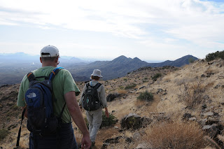
Here’s a sweet little side trip to consider when hiking one of the longer trails in the McDowell Sonoran Preserve. The turn off for this spur trail is located at emergency marker TL1 on the Tom’s Thumb Trail—you can’t miss it. From here, it’s an easy uphill jaunt along a desert ridgeline featuring magnificent views and interesting geology. Topping out at 3,858 feet, the trail dead-ends at the abrupt edge of the ridgeline where unobstructed vistas roll out in all directions showcasing the steep slopes of Thompson Peak, Fountain Hill’s famous water spout and the ring of mountain ranges surrounding the Valley of the Sun.
LENGTH: 1 mile roundtrip (5.8 miles total from North Access Area or 11.6 miles from Gateway Access Area)
RATING: easy-difficult depending on your route
ELEVATION: 3,500-3,858 feet (from the trail junction)
GETTING THERE:
NORTH ACCESS:
From the Loop 101 in Scottsdale, take the Pima Road/Princess Drive exit and go north on Pima to Dynamite/RioVerde Drive. Turn right and continue east to 128th Street. Go right (south) on 128th St. and follow the signs to the temporary trailhead. As of January 2010, the last few miles are on unmaintained dirt roads. Although there are a few rough spots, we got through in passenger cars, but wouldn’t attempt it when the roads are wet.
A mo-better trailhead, which will be called the North McDowell Access Area, is scheduled to open in 2011. Check the Web site below for additional access points and loop hike options.
INFORMATION: www.scottsdaleaz.gov/preserve


 LOOKOUT TRAIL
McDowell Sonoran Preserve
Here’s a sweet little side trip to consider when hiking one of the longer trails in the McDowell Sonoran Preserve. The turn off for this spur trail is located at emergency marker TL1 on the Tom’s Thumb Trail—you can’t miss it. From here, it’s an easy uphill jaunt along a desert ridgeline featuring magnificent views and interesting geology. Topping out at 3,858 feet, the trail dead-ends at the abrupt edge of the ridgeline where unobstructed vistas roll out in all directions showcasing the steep slopes of Thompson Peak, Fountain Hill’s famous water spout and the ring of mountain ranges surrounding the Valley of the Sun.
LENGTH: 1 mile roundtrip (5.8 miles total from North Access Area or 11.6 miles from Gateway Access Area)
RATING: easy-difficult depending on your route
ELEVATION: 3,500-3,858 feet (from the trail junction)
GETTING THERE:
NORTH ACCESS:
From the Loop 101 in Scottsdale, take the Pima Road/Princess Drive exit and go north on Pima to Dynamite/RioVerde Drive. Turn right and continue east to 128th Street. Go right (south) on 128th St. and follow the signs to the temporary trailhead. As of January 2010, the last few miles are on unmaintained dirt roads. Although there are a few rough spots, we got through in passenger cars, but wouldn’t attempt it when the roads are wet.
A mo-better trailhead, which will be called the North McDowell Access Area, is scheduled to open in 2011. Check the Web site below for additional access points and loop hike options.
INFORMATION: www.scottsdaleaz.gov/preserve
LOOKOUT TRAIL
McDowell Sonoran Preserve
Here’s a sweet little side trip to consider when hiking one of the longer trails in the McDowell Sonoran Preserve. The turn off for this spur trail is located at emergency marker TL1 on the Tom’s Thumb Trail—you can’t miss it. From here, it’s an easy uphill jaunt along a desert ridgeline featuring magnificent views and interesting geology. Topping out at 3,858 feet, the trail dead-ends at the abrupt edge of the ridgeline where unobstructed vistas roll out in all directions showcasing the steep slopes of Thompson Peak, Fountain Hill’s famous water spout and the ring of mountain ranges surrounding the Valley of the Sun.
LENGTH: 1 mile roundtrip (5.8 miles total from North Access Area or 11.6 miles from Gateway Access Area)
RATING: easy-difficult depending on your route
ELEVATION: 3,500-3,858 feet (from the trail junction)
GETTING THERE:
NORTH ACCESS:
From the Loop 101 in Scottsdale, take the Pima Road/Princess Drive exit and go north on Pima to Dynamite/RioVerde Drive. Turn right and continue east to 128th Street. Go right (south) on 128th St. and follow the signs to the temporary trailhead. As of January 2010, the last few miles are on unmaintained dirt roads. Although there are a few rough spots, we got through in passenger cars, but wouldn’t attempt it when the roads are wet.
A mo-better trailhead, which will be called the North McDowell Access Area, is scheduled to open in 2011. Check the Web site below for additional access points and loop hike options.
INFORMATION: www.scottsdaleaz.gov/preserve
No comments:
Post a Comment